
The Dinantian (Mississippian) succession of southern Belgium and surrounding areas: stratigraphy improvement and inferred climate reconstruction
Abstract
The interactions between sea-level changes, local and global tectonics, and palaeoclimates have influenced the sedimentary deposition and the stratigraphy of the Belgian Dinantian. This paper emends the Belgian Dinantian sequence stratigraphy pattern and the third-order sequence 4 is divided into two sequences (4A, 4B). We also confirm that the sudden sea-level drop corresponding to the Hangenberg Sandstone at the Devonian – Carboniferous transition does not correspond to a third-order sequence boundary, but to an out-of-sequence event. The stratigraphy of the Tournaisian in the Namur, South Avesnois and Vesdre – Aachen sedimentation areas is clarified and leads to restrict the latter area to the Aachen vicinity only. The shape of the Namur – Dinant basin is revised and shows a migration of the depocenter northward during Dinantian times. During the Tournaisian, precession cycles are well developed and correspond to alternations of monsoon and dryer climates, without marked changes in the sea level. However, superimposed on these alternations, the Tournaisian third-order sequences recorded higher sea-level variations, which are considered to be due to glacio-eustatism, indicating long-duration period of ice formation. The very strong fall in the sea-level at the Tournaisian – Viséan boundary is considered to record the development of an ice-cap and to a heralding change to the Carboniferous climate with glaciations. From that time (sequence 5), marked eccentricity parasequences developed during the Viséan, recording alternating shorter interglacial-glacial periods. Thus, the onset of the Carboniferous glaciations is as early as the Early Viséan and not in the Late Viséan as usually considered.
1. Introduction
1After fundamental works such as those of de Dorlodot (1910) and Delépine (1911), the stratigraphy and the sedimentology of the Belgian Dinantian – a term better describing the Lower Carboniferous carbonate strata in western and central Europe than ‘Mississippian’ – were the subject of numerous papers during the 1960th and 1980th by various authors (Pirlet, Groessens, Bless, Bouckaert and others), mainly under the leadership of Raphaël Conil. Especially the litho- and biostratigraphic work was summarized in two important synopses: Paproth et al. (1983) and Conil et al. (1991). In the first decade of this century, the older stratigraphic framework has been significantly revised and new basin-wide correlation schemes have been developed using bio-, chrono-, litho- and sequence stratigraphy – mainly in Hance et al. (2001, 2002, 2006), Poty et al. (2002a, 2006) and Devuyst (2006, for the Tournaisian – Viséan boundary). These works led to a relatively coherent bio-, litho- and sequence stratigraphic model, which can be efficiently used in the Eurasia realm in shallow-water (e.g. Hance et al., 2011; Poty et al., 2007, 2014) and deeper water facies (e.g. Aretz, 2016, this volume; Herbig, 2016, this volume). This model also enabled the redefinition of the Belgian substages. Their boundaries can be correlated globally, which shows their high potential for further chronostratigraphic subdivision of the Carboniferous (Poty et al., 2014).
2Consequently, the Dinantian succession of the Namur – Dinant Basin is currently one of the best known and documented, together with the Irish-British one (Waters et al., 2011). That high knowledge is obviously due to (1) the long tradition and high quality of scientific research in this area, (2) the ideal conditions of access and exposure of the Carboniferous deposits in the geographically restricted area of southern Belgium and adjacent French and German successions, and (3) the huge amount of quarries, natural outcrops, road and railway cuts providing high quality sections.
3However, uncertainties remained, notably (1) the precise stratigraphic age of dolomitized formations in the Namur and south Avesnois sedimentation areas, (2) the correlation of the succession in the Vesdre – Aachen area, (3) the boundaries and transitions between the various palaeogeographical units, (4) the orbitally-forced cycles that drove the sedimentation during the Latest Famennian – Late Viséan interval, and (5) the evolution of the depocenter of the basin. On another hand, a considerable amount of data concerning mainly sedimentology and sequence stratigraphy, so far only available in the unpublished works of master students and from the author need to be included in the general frame. The complex interactions between sea-level changes, local and global tectonics and palaeoclimates have been identified as driving the sedimentary deposition during Dinantian times.
4It is the aim of this paper to highlight these interactions and their effects on the stratigraphy, and to complete the above-cited ‘classical’ papers for a more and more exhaustive comprehension of the Belgian Dinantian in a global context.
Abbreviations
5ASA: South Avesnois sedimentation area, CSA: Condroz sedimentation area, DCB: Devonian – Carboniferous Boundary, DSA: Dinant sedimentation area, Fm: Formation, FSST: falling-stage system tract, HAS: Hainaut sedimentation area, HBS: Hangenberg Black Shale, HSS: Hangenberg Sandstone, HST: highstand system tract, LST: lowstand system tract, KB: Campine Basin, Mbr: Member, NSA: Namur sedimentation area, NDB: Namur – Dinant Basin, TST: transgressive system tract, TVB: Tournaisian – Viséan Boundary, VASA: Vesdre – Aachen sedimentation area, VSA: Visé – Maastricht sedimentation area.
2. Geological setting
6During the Dinantian, the named Namur – Dinant Basin (NDB, Fig. 1) was situated south of the emerged London – Brabant Massif. Note that the term ‘basin’ is used herein in the classically use in Belgium for the definition of the water mass limited by continental margin(s) and developed on a continental crust, but not in the sense of a deep-water basin, such as the Rhenish Kulm Basin.
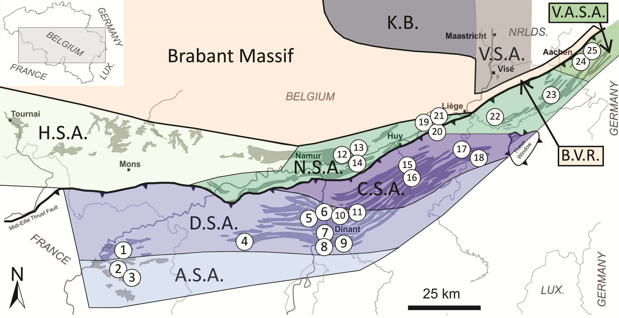
7Figure 1. Dinantian sedimentation areas in the Namur – Dinant Basin and location map of the main sections cited in the text. Abbreviations: ASA: South Avesnois sedimentation area, BVR: Booze – Le-Val-Dieu ridge, CSA: Condroz sedimentation area, DSA: Dinant sedimentation area, HSA: Hainaut sedimentation area, KB: Campine Basin, NSA: Namur sedimentation area, VASA: Vesdre – Aachen sedimentation area, VSA: Visé – Maastricht sedimentation area. The ASA is extended eastward, because facies in the southwestern part of the Dinant area (Hemptinne) are similar to those known in the Avesnes area at the margin of the DSA just north of the ASA. The DSA is extended northeastward, because Waulsortian facies have been recognized in the Néblon river valley, an affluent of the Ourthe river. The VASA is limited to the Aachen area, and does not include the Eupen area (as considered by Aretz et al., 2006 and Poty et al., 2011a), which is considered to belong to the NSA. Section numbering: 1: Limont-Fontaine quarry, 2: Ardennes quarry (Avesnes-sur-Helpe), 3: Bocahut (Godin) quarry (Avesnes-sur-Helpe), 4: Hemptinne section, 5: Tanret quarry and Salet road section, 6: Hun section (Yvoir), 7: Anseremme railway section, 8: Bruyères and Pauquis Rocks (Waulsort), 9: Gendron-Celles railway section, 10: Leffe quarry (Dinant), 11: Chansin (‘Les Nutons’) quarry (Spontin), 12: Marche-les-Dames quarry, 13: Seilles quarry (Andenne), 14: Plates-Escailles quarry (Maizeret), 15: Royseux railway cutting, 16: Chabofosse, Royseux (sections I, II & III), 17: Chanxhe and Pont-de-Scay sections, 18: Martinrive section, 19: La Mallieue quarry (Engis), 20: Engihoul quarry (Engis), 21: Chokier railway cutting, 22: Bay-Bonnet quarry (Fléron), 23: Carnol quarry (Eupen), 24: Bernardshammer and Binsfeldhammer quarries and Stolberg section, 25: Hastenrath quarry. See also Appendix 1 for GPS coordinates of the sections.
8The NDB extended westward farther than the area of its current outcrops within the Rhenohercynian fold belt (the Boulonnais area of north France, the Namur Synclinorium, the Vesdre – Aachen area, the Dinant Synclinorium) and was connected to the southwest British Province and Ireland (Delépine, 1911). Northward, it was connected with the Campine Basin (KB, Fig. 1) during the Late Devonian and the Early Tournaisian, along the eastern margin of the Brabant Massif, in the Visé area. From the Late Tournaisian and during the Viséan, the NDB was separated from the KB by the rising Booze – Le-Val-Dieu ridge (Poty & Delculée, 2011). Eastward, the NDB was possibly connected with the German Kulm Basin during the Tournaisian and the beginning of the Viséan, through the Aachen area (VASA), but not afterward, as suggested by the lack of Middle and Upper Viséan deposits as a result of the uplift of the area. Unlike the usual reconstruction (see for example Van Steenwinkel, 1990), during the Dinantian, the NDB was not connected southward to the Rhenohercynian (Cornwall – Rhenish) Basin, from which it was separated by the first stage of the Variscan emersion of the Ardenne Massif (see 5.3). These poor connections with adjacent basins explain the abundance of restricted and poorly open inner platform facies in the Viséan strata of the NDB.
9Seven palaeogeographic areas corresponding to tectono-sedimentary units (Fig. 1), having their own stratigraphic evolution, have been recognized in the Dinantian of the NDB (Poty, 1997; Hance et al., 2001, 2002; Aretz et al., 2006; Poty et al., 2011a). These are the Condroz sedimentation area (CSA), the Dinant sedimentation area (DSA) running westward up to the Boulonnais area in N France, the Hainaut sedimentation area (HSA), the Namur sedimentation area (NSA), the southern Avesnois sedimentation area (ASA), the Vesdre – Aachen sedimentation area (VASA) and the Visé – Maastricht sedimentation area (VSA).
10However, it has to be noted that no real advance in the knowledge of the HSA has been achieved in recent years, apart from the revision of its lithostratigraphy (Poty et al., 2002a), mainly based on the new geological mapping of Wallonia (Hennebert & Doremus, 1997a, 1997b; Hennebert, 1999). Its stratigraphy, its tectono-eustatic sedimentary evolution and the correlations with the other areas of the NDB are still only partially understood. Hence, the HSA will not be considered here, leaving a wide field open for future research.
3. Sequence stratigraphy
11The first sequence stratigraphic model of the Lower Carboniferous was realized by Ramsbottom (1973, 1979) who defined nine ‘mesothems’ for the Tournaisian – Viséan interval in England. His mesothems are based on the relative sea level recorded in the deposits, starting with transgressive subtidal marine limestone and ending with peritidal limestone. Indeed they were considered as similar, at a larger scale, to the shallowing upward parasequences known at the time in the Upper Viséan and in the Upper Carboniferous.
12However, they do not correspond to the third-order cycles sensu Vail (1987) and Haq et al. (1987), in which the relative deeper facies are not correlated with the beginning of the cycles, but with the transgressive-highstand system tracts (TST-HST) transition (Hance et al., 2001). Therefore, the boundaries between the Ramsbottom’s cycles roughly correspond to the maximum flooding surface of the third-order cyclicity model. However, Ramsbottom’s mesothems were included in the Dinantian cycle chart of Ross & Ross (1988), and then, incorrectly and without any discussion or emendation, in more recent papers such as in Haq & Schutter (2008).
13In Belgium, Conil et al. (1977) defined two and three stages respectively in the Tournaisian and the Viséan, which, at the time, were considered as series (currently stages). These stages (currently substages) were considered to correspond to transgression-regression cycles having directed shifts and distribution of fauna. A sixth cycle corresponding to the latest Viséan was also recognized, but imperfectly recorded in Belgium.
14Later, Paproth et al. (1983) described three and four sequences respectively for the Tournaisian and the Viséan (A to F in Fig. 2), the first Tournaisian one including the Strunian. As for the British mesothems of Ramsbottom, these sequences were shallowing-upward and their base marked by open marine facies and by a significant biostratigraphic shift. The first two Tournaisian sequences of Paproth et al. (1983) matches more or less the first two sequences defined by Hance et al. (2001, 2002), whereas the third one covers the sequences 3 and 4 of Hance et al. The first Viséan sequence of Paproth et al. (1983) comprised the entire Lower Viséan, but at this time, the gap of the lowermost Viséan in the shallow-water areas was not yet recognized, and a part of the Upper Tournaisian (Longpré Fm, Godin Fm) was included in it, whereas the Lower Viséan covers the sequences 5 and 6 of Hance et al. The second Viséan sequence of Paproth et al. comprises the Livian (sub-)stage, and corresponds to the sequence 7 and the TST of the sequence 8 of Hance et al. The third Viséan sequence of Paproth et al. corresponds to the HST of the sequence 8 and to the sequence 9 (lower Warnantian) of Hance et al. The fourth Viséan sequence of Paproth et al. comprises the upper Warnantian, but was not considered in the first sequence stratigraphic model of Hance et al. and subsequent publications.
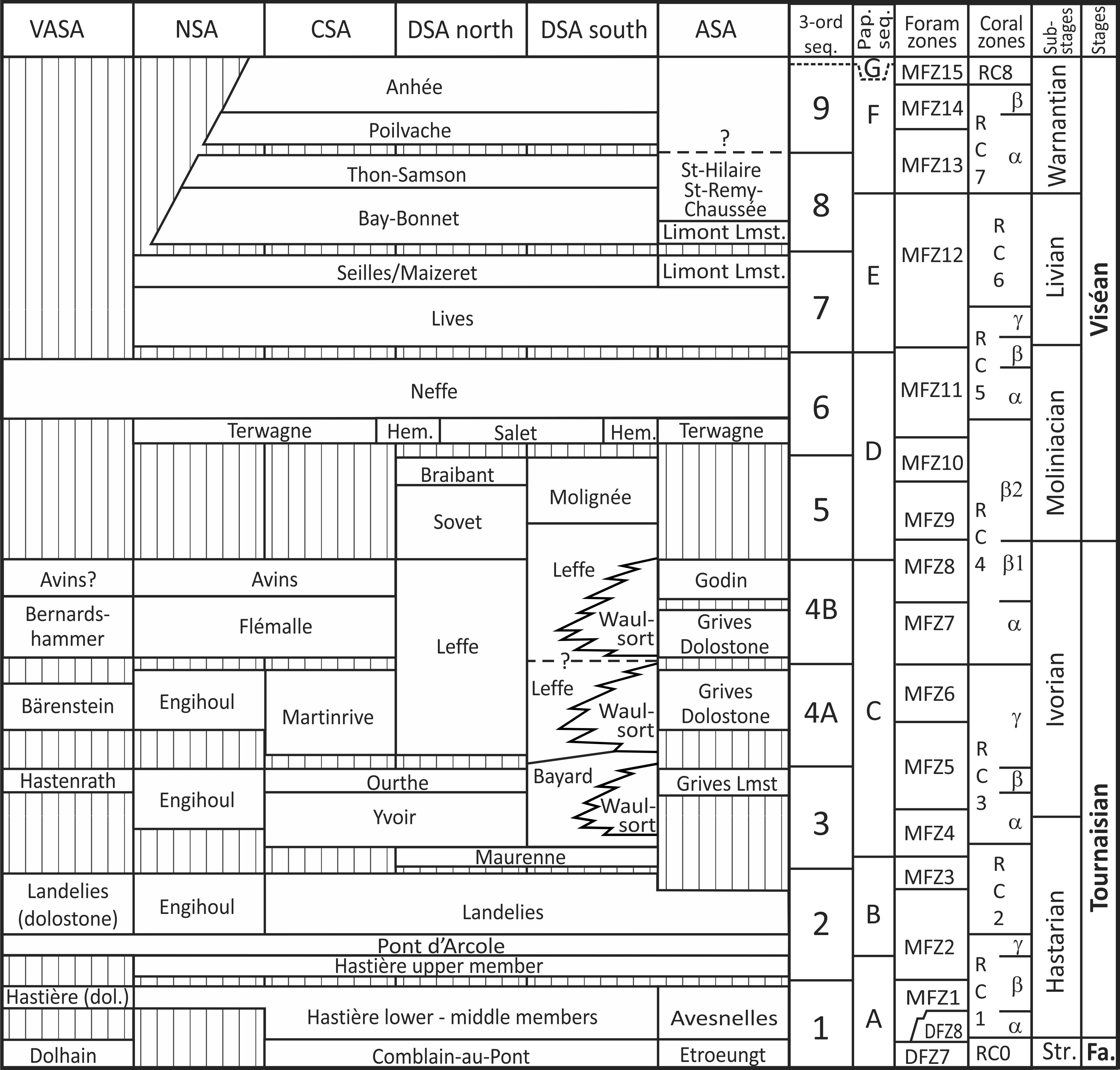
15Figure 2. Emended stratigraphic pattern of the Dinantian in southeastern Belgium with indication of the third-order sequences. Abbreviations: ASA: South Avesnois sedimentation area, CSA: Condroz sedimentation area, DSA: Dinant sedimentation area, NSA: Namur sedimentation area, VASA: Vesdre-Aachen sedimentation area, 3-ord seq.: third-order sequences, Pap. seq.: sequences of Paproth et al. (1983), dol.: dolomitized, Fa.: Famennian. Hem: Hemptinne Fm, Lmst.: Limestone, Str.: Strunian; gaps are indicated by striped pattern. Modified from Poty et al. (2006, 2011a).
16The first sequence stratigraphic depositional model based on Vail (1987) was proposed by Van Steenwinkel (1990) for the interval around the DCB in the NDB. The current model (Hance et al., 2001, 2002) extends from the Strunian to the base of the upper Warnantian and is valid for the entire NDB.
17The sequences defined by Hance et al. (2001) were based on Vail’s (1987) model, which recognized three system tracts in a cycle: a lowstand system tract (LST), a transgressive system tract (TST) and a highstand system tract (HST). In Vail’s model, these three stages are separated by surfaces with temporal value: the transgressive surface between the LST and the TST, the maximum flooding surface between the TST and the HST, and the downward shift between the HST and the LST.
18In the Belgian sequences, Hance et al. (2001) initially did not recognize lithological units identifiable to LST (except for their sequence 3). What they regarded as HST and TST are separated by sharp lithological boundaries (usually corresponding to paraconformities), which they considered as corresponding to regressive-transgressive surfaces, and to a gap of the LST.
19On the other hand, there was usually a strong accommodation during the sea level rise triggering the development of shallow-water facies throughout the TST, without marked deepening-upwards trend. That prevented Hance and co-authors to recognize the maximum flooding surfaces. Hence, they recognized, at best, a ‘maximum flooding zone’. So, they made the choice to put the TST-HST boundaries at lithostratigraphic boundaries (between formations and/or members) corresponding more or less to these tracts.
20Consequently, Hance et al. (2001)’s model includes usually only two systems tracts, corresponding in fact to the transgressive and regressive systems tracts of Johnson & Murphy (1984).
21Later, Devuyst et al. (2005) and Poty et al. (2006, 2011a, 2014) considering the four tracts model of Hunt & Tucker (1992, 1993), which better fits the Belgian Dinantian succession, emended progressively Hance et al. (2001)’s model. They recognized in most of the sequences a falling-stage system tract (FFST) and a lowstand systems tract (LST) sensu Plint & Nummedal (2000), i.e. separated by a regressive-transgressive surface such as the well-marked paraconformities of the Belgian Dinantian. Their model was more consistent than the previous one in the definition and the nomenclature of its units. This amendment did not change any sequence boundaries from the original Hance et al.’s model, because Hunt & Tucker (1992) and Plint & Nummedal (2000) were followed in placing the sequence boundary above the FSST, not at its base, as suggested by Posamentier & Allen (1999). Therefore, the authors used as sequence boundary a diachronous subaerial surface capping the HST in the most proximal areas, and the top of the FSST in the most distal ones. That corresponds usually to formation and member boundaries and is easily traceable and practical in field investigations.
22The Belgian Dinantian sequence stratigraphy, supported by robust biostratigraphic dates, was successfully extended to the Boulonnais in northern France (Hance et al., 2001), England (Hance et al., 2002), southern France (Poty et al., 2002b; Aretz, 2016, this volume), Poland (Poty et al., 2007), China (Poty et al., 2011b; Hance et al., 2011), NW Turkey (Denayer, 2014) and recently in Germany (Herbig, 2016, this volume). These correlations allowed us to check, to detail, to complete and to globalize the Belgian Dinantian sequence stratigraphy (Poty et al., 2014). Moreover, the two sequences recognized in the uppermost Viséan (upper Warnantian, British Brigantian substage), by Giles (1981) and Ross & Ross (1988) were well recognized in South China and integrated in the global model of Hance and co-authors (Poty et al., 2011b).
23Since then, some amendments to the sequence stratigraphic model in the NDB have to be made. They consist essentially in splitting the sequence 4 into two sequences (4A and 4B) and recognizing of the Tournaisian sequences in the dolostone formations developed in the NSA and in the ASA, and in the limestone formations of the VASA. On the other hand, the recognition and the determination of the orders of minor cycles allow an attempt of calibration of the duration of the third-order sequences to be done. Furthermore, it makes possible to precise the type of climatic control of the different sequences and their link with the Dinantian glaciations.
3.1. The Devonian – Carboniferous Boundary as a sequence boundary?
24The NDB is a classical study area for the Devonian – Carboniferous transition (among others: Conil & Lys, 1970, 1980; Conil et al., 1986). During the uppermost Famennian and lowermost Tournaisian interval, relatively thick series of shallow-water siliciclastics progressively switched into carbonate deposits. They allow a good understanding of the Famennian – Tournaisian transition and of the crisis affecting the marine ecosystems at the DCB. Being thicker and more complete for the record of local and global sea-level and/or facies changes, the shallow-water sections are better than deeper facies, so-called condensed – in fact discontinuous and lacunar – sections, that have long been preferred by the biostratigraphers for their high conodont content.
25In the NDB, due to the absence of a good record of the Siphonodella lineage, the DCB was drawn just above the last conodonts of the praesulcata Zone, hence just above the extinction level of the Devonian fauna, e.g. quasiendothyrid foraminifers, cryptophyllid ostracods, Strunian rugose corals, brachiopods and trilobites (Conil et al., 1977, 1986). This criterion, although not matching the ICS standards, is highly pragmatic because based on the recognition of the rather abundant last Devonian fauna in the Belgian shallow-water sections. On the other hand, the scarcity or the lack of conodonts around the DCB everywhere in the shallow-water facies prevents their effective use for the definition and the recognition of a boundary.
26In the NDB, the Hangenberg Black Shale (HBS) is missing. This absence was interpreted as a stratigraphic gap due to a sea-level drop by Van Steenwinkel (1990), relying on the non-recognition of biozones such as the Retispora lepidophyta – Verrucosisporites nitidus (LN) palynozone.
27Van Steenwinkel (1990, 1993) considered that the sea-level drop coincided with a third-order sequence boundary, a view usually followed by latter authors: the Strunian Comblain-au-Pont/Etroeungt formations formed the HST, the hiatus corresponded to the sequence boundary, the Hastière Fm was a LST, the Pont d’Arcole Fm a TST and the Landelies Fm a HST.
28However, on one hand, in relatively shallow-water facies in Pomerania, Matyja et al. (2015) showed that the Hangenberg Shale was not developed in the interval where the LN Zone was well recorded. On the other hand, Prestianni et al. (2016, this volume) revising the palynomorph content of the Belgian Strunian concluded that the LN Zone is an ecozone of the contemporaneous LE Zone, rather than a biozone and thus has no stratigraphic value. Similarly, the DFZ8 Foraminifer Zone (Tournayellina pseudobeata interval zone) defined in the Avesnelles Fm (ASA) by Devuyst & Hance (in Poty et al., 2006), and correlated with the basal beds of the Hastière Fm in Belgium (Fig. 3, bed 159 at Anseremme), is also an ecozone equivalent to the MFZ1 (Unilocular) Zone of the same authors, as indicated by the litho- and biostratigraphic (RC1, Conilophyllum interval Zone) correlation of the Avesnelles Fm with the two lower members of the Hastière Fm (Fig. 2).
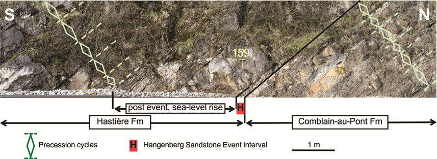
29Figure 3. Devonian – Carboniferous boundary interval showing the regular precession cycles below and above the level correlatable with the Hangenberg sandstone interval (base of bed 159) and its aftereffect. Anseremme railway section, Dinant, DSA.
30That suggests that there is no gap corresponding to the LN or to the DFZ8 Zones in the NDB sections as previously suggested, and that the HBS was not marked, as in Pomerania. Its anoxic facies did not spread into the shallow-water environments of the NDB, or possibly, only occasionally, through some decimetre- to metre-thick black shale horizons with impoverished marine faunas, such as dysoxic-water pelecypods (e.g. in the Martinrive section in the CSA, Mottequin & Poty, 2014). These horizons can be considered as inputs of dysoxic anoxic waters from deeper areas where HBS developed. In the NDB, carbonate facies rich in benthic fossils continued to develop during the HBS interval, and no extinction on the platform was linked to it.
31On the contrary, the following Hangenberg Sandstone (HSS), which reflects a strong sea-level drop, is easily recognizable and traceable in the VASA (Stolberg section) and the CSA (Royseux railway cutting, Martinrive section, Pont de Scay section). It corresponds to a decimetre- to metre-thick sandstone-siltstone or more or less sandy limestone horizon that frequently includes reworked pre-Hangenberg fauna (brachiopods, foraminifers, rugose corals). In the Anseremme section (DSA), the basal 10-15 cm of bed 159 at the base of the Hastière Fm (unit 2 of Van Steenwinkel, 1990) yielded the same reworked fossils (Conil et al., 1986; Poty et al., 2006; Fig. 4A-B) and can be correlated with this regressive event (Fig. 3). In the same section, the upper part of the bed 159 yields Protognathodus kockeli (Bouckaert & Groessens, 1976) indicating a post-HSS deposition (Kaiser et al., 2015; Becker et al., 2016).
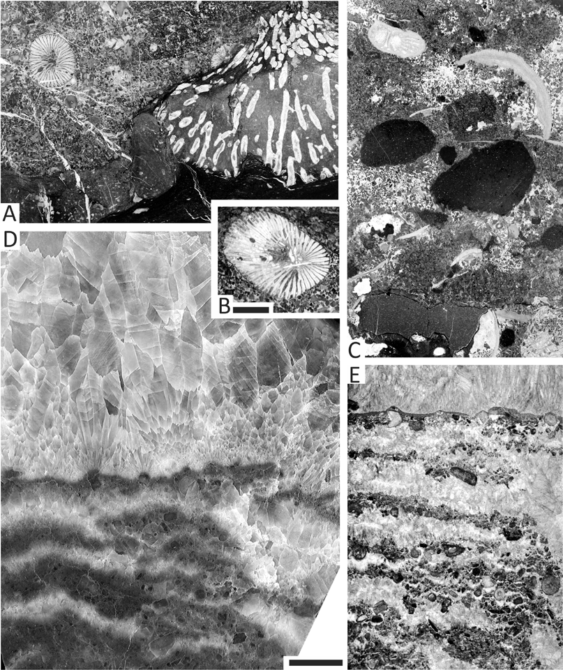
32Figure 4. Strunian to Lower Viséan facies encountered in the NDB. A: reworked Strunian Campophyllum gosseleti (left) and syringoporoid (right) at the base of the Hastière Fm that recorded the Hangenberg Sandstone brutal regression, base of bed 52, Gendron-Celles section (southern DSA); B: reworked Strunian Campophyllum gosseleti with perforations, base bed 52, base of the Hastière Fm, Gendron-Celles section (southern DSA); C: sedimentary breccia at the base of the Salet Fm, corresponding to the FSST-LST of sequence 6, Tanret quarry at Salet (southern DSA); D: calcite pseudomorph of large selenite crystals, evaporitic deposit filling a karstic depression, top of Engihoul Fm, Engihoul quarry (NSA); E: calcite pseudomorph from selenitic gypsum layers alternating with crinoidal rudstone layers probably corresponding to tempestites from more distal environments, top of Engihoul Fm, Engihoul quarry (NSA). Scale bar equals 10 mm for A, B-E (x1.5) and 5 mm for B (x2).
33Therefore, in the NDB, the extinction event perfectly fits the sudden sea-level drop corresponding to the Hangenberg Sandstone and reflected by the deposition of sandstone and more or less sandy limestone in proximal facies. The HSS and equivalents (extreme base of the Hastière Fm) do not fit into the succession of the upper part of the Comblain-au-Pont Fm and of the lower member of the Hastière Fm, which are mainly controlled by precession cycles (Fig. 3) (see 4.2.1.). In the Royseux railway cutting (CSA) and in the Anseremme and Gendron-Celles sections (DSA), this remarkable horizon overlies sharply the shaly level of the last Strunian precession cycle (i.e. during the green house interval) and is overlain by deposits corresponding to the fast, post-event, sea-level rise and the return to the previous environments and the continuing development of precession cycles. Therefore, this horizon does not correspond to a third-order sequence boundary, but to an out-of-sequence event. Indeed, the third-order sequence boundary between sequences 1 and 2 corresponds to the disconformity between the middle and the upper members of the Hastière Fm in Hance et al. (2001, 2002) and Poty et al. (2006, 2011a)’s models, or to a disconformity at the top of the Avesnelles Fm in the ASA (Fig. 5). That disconformity is moreover well marked everywhere in Eurasia (South China, Hance et al., 2011; Poland, Poty et al., 2007; NW Turkey, Denayer, 2016). Other arguments proving that the fall of the sea-level at the DCB is not a third-order sequence boundary have been noted by Hance et al. (2001) and Denayer et al. (2015): (1) the very similar facies across the DCB are difficult to separate into different system tracts, (2) the very homogenous composition of the middle member of the Hastière Fm and its wide extension in the NDB are typical of a HST. The Hangenberg Sandstone is consequently a key level for correlation between shelf and basin close to the DCB, which can also be recognized everywhere (Becker et al., 2016).
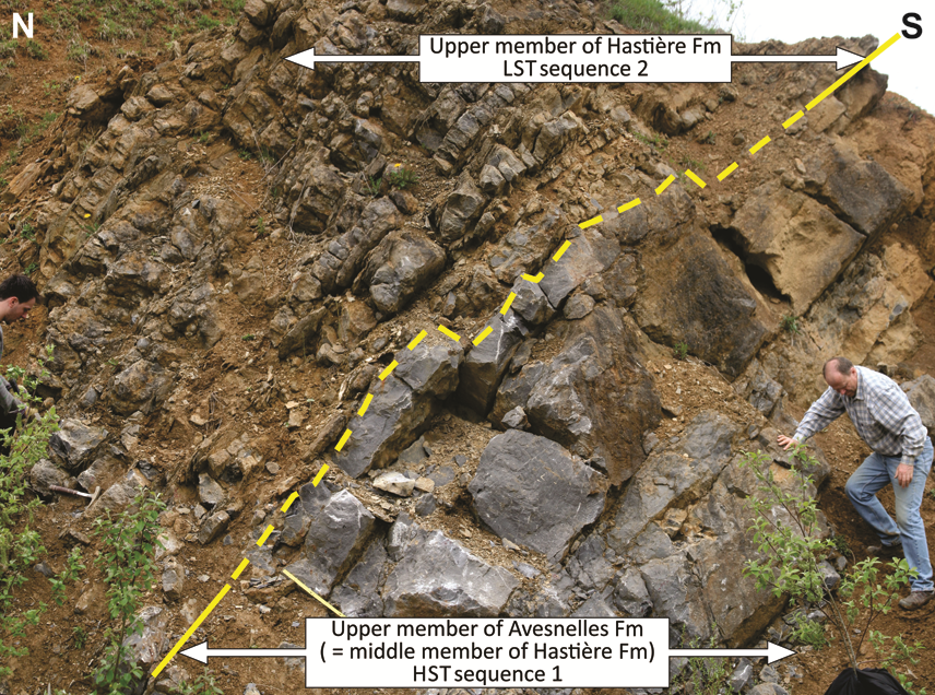
34Figure 5. Disconformity between the Avesnelles Fm and the upper member of the Hastière Fm corresponding to the boundary between sequences 1 and 2. Ardennes quarry at Godin (ASA, France).
3.2. The splitting of the sequence 4 into 4A and 4B
35In Hance et al. (2001)’s model, sequence 4 is the last Tournaisian sequence composed of a TST corresponding to the Martinrive Fm and a HST corresponding to the Flémalle and Avins members of the Longpré Fm. In the CSA, the top of the Martinrive Fm is marked by a palaeokarstic surface, which was considered by Hance et al. (2001, 2002) as corresponding to an emersion due to a local, relative small-scale sea level lowering preceding the HST, possibly tectonically controlled. However, this same disconformity is now clearly recognized in the NSA (e.g. in the Carnol, Marche-les-Dames, and La Mallieue quarries) and in the ASA (Bocahut quarry). Moreover, the Martinrive Fm can be divided into two members: a lower member characterized by thinly-bedded cherty mudstone and wackestone with crinoidal layers, and an upper member characterized by thickly-bedded peloidal mudstone to grainstone, almost devoid of cherts, but with numerous calcitic chicken-wire structures, sometimes silicified or dolomitized. The two members correspond respectively to a relatively deep-water TST and to a shallower HST. Similarly, the evolution of the Longpré Fm shows a relative deepening during the deposition of the Flémalle Mbr, with a maximum depth near the top of the member, and then a shallowing recorded in the Avins Mbr. Therefore, the two members could correspond respectively to a TST and a HST-FSST, and not only to a HST as considered by Hance et al. (2001, 2002) and Poty (2007). This clear double pattern implies to divide the former sequence 4 into two sequences 4A and 4B (Fig. 2).
36In the northern part of the DSA, the sequences 4A and 4B are not clearly individualized and their boundaries not yet recognized in the Leffe Fm. However, in the southern part of the DSA, Dupont (1969) recognized three superimposed Waulsortian buildups (banks 1, 2 and 3 of Dehantschutter & Lees, 1996) in the Pauquis syncline at Waulsort. Their development could be linked to the TST and the HST, and their demise to the FSST and LST of the three sequences 3, 4A and 4B (Fig. 2).
37The stratified cherty limestone (Bayard Fm) of the interval between the lower and the middle Waulsortian buildups (Pauquis bank 1 and bank 2) belongs to the upper MFZ5 (Poty et al., 2006; after Dehantschutter & Lees, 1996), and was considered as corresponding to the beginning of the TST of the sequence 4 (now 4A) by Hance et al. (2001, 2002).
38Nevertheless, after Dehantschutter & Lees (1996), the middle buildup (Pauquis bank 2) and overlying stratified cherty limestone separating it from the Bruyères buildup (a lateral equivalent of the Pauquis bank 3) entirely belong to the Dollymae bouckaerti Subzone (= upper part of the Polygnathus communis carina Zone), i.e. to the end of the sequence 3 or the lower part of the sequence 4A. Consequently, it is currently difficult to correlate the development of the middle phase of the Waulsortian buildups with the sequence 4A and its demise to the sea level fall at the end of this sequence. However, the upper part of the neighbouring buildup of the Bruyères anticline (Dehantschutter & Lees, 1996) yields Darjella (= Lugtonia) monilis, indicating the MFZ7 Zone. This third and last Waulsortian phase is to be correlated, at least partly, with the lower part of the sequence 4B.
3.3. Sequence stratigraphy of the Tournaisian strata in the Namur sedimentation area
39In the NSA, but also in the northern CSA and ASA, the Tournaisian units vary considerably laterally and are locally intensely dolomitized. These units were poorly dated and superficially correlated with the other areas (Paproth et al., 1983; Poty et al., 2002a), because the traditional tools for correlation – e.g. microfossils and primary sediment components – are not or poorly preserved.
40However, some main sedimentological structures are sometimes preserved, such as the bedding and the stratigraphic discontinuities, and in some cases, macrofossils (echinoderms, brachiopods and corals) also can be preserved as dolomitized ‘fossil ghosts’, allowing some determinations (mainly for corals). These useful markers have allowed to distinguish several lithostratigraphic units, to determine their biostratigraphic position, to correlate them with their lateral non-dolomitized equivalents, to recognize disconformities, and therefore to integrate them into the Belgian bio-, litho- and sequence stratigraphic framework.
3.3.1. The Namur Dolostone Group in Marche-les-Dames (with collaboration of N. Pirotte and A. Lauwers)
41As previously stated (Paproth et al., 1983), the dolomitization in the Marche-les-Dames section (Namur vicinity) affects a c. 250 m-thick stratigraphic sequence, extending from the basal Tournaisian up to the top of the upper Moliniacian Neffe Fm or to the base of the Livian Lives Fm. The Marche-les-Dames quarry, supplemented downward by boreholes, exemplifies that succession. There are, from the bottom to the top (Fig. 6):
42- 8 m of shale of the Pont d’Arcole Fm resting directly on Upper Famennian siliciclastics;
43- 79 m of dolostone (Engihoul Fm) in which 5 units can be recognized:
44→ unit 1: 20 m of massive dolostone;
45→ unit 2: 15 m of siliceous dolostone, with some cherts;
46→ unit 3: 2 m of black argillaceous dolostone overlain by 13 m of crinoidal dolostone with micheliniids;
47→ unit 4: 11 m of coarse-grained dolostone without visible bioclasts;
48→ unit 5: 20 m of thinly-bedded dolostone, with calcite nodules and layers of crinoids (upper part of the Engihoul Fm sensu Poty et al., 2002a).
49- 70-80 m of crinoidal dolostone yielding Sychnoelasma hawbankense (RC4 coral Zone), with some metres of dolomitized oolites at the top; it clearly corresponds to the dolomitized Flémalle and Avins Mbrs of the Longpré Fm (A. Lauwers, personal communication), and is sharply separated from the underlying unit by an argillaceous layer;
50- 50 m of well-bedded dolostone, brecciated in its lower part, and sequences with dolomitized stromatolites at the top, corresponding to the Terwagne Fm;
51- a 40 m-thick massive dolostone, including some non-dolomitized grainstone, with Dorlodotia briarti, and easily identified as the Neffe Fm;
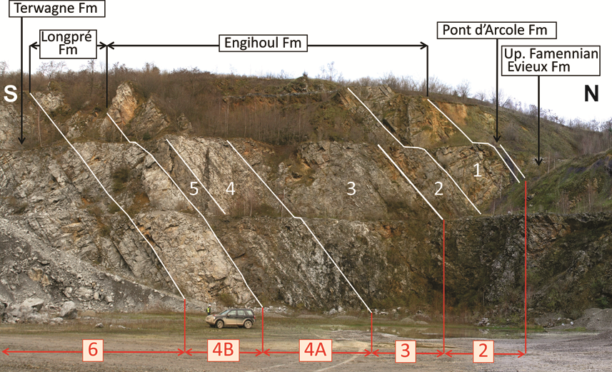
52- the 35 m-thick Haut-le-Wastia Mbr of the Lives Fm, only partially dolomitized.
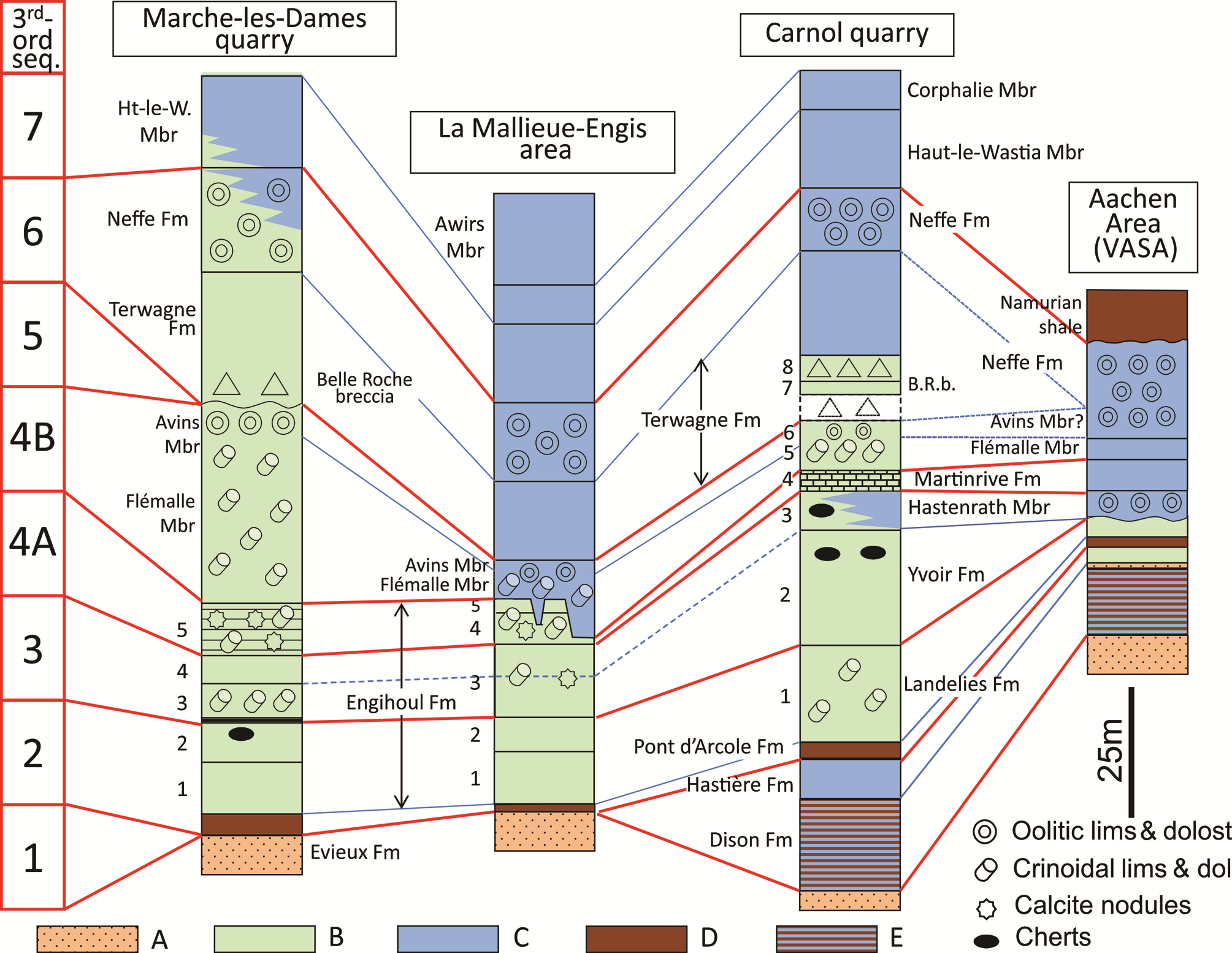
53Figure 6. Sequence stratigraphy and correlation of the Tournaisian and Lower-Middle Viséan in NSA and VASA. Legend: A: sandstone, siltstone and shale of the Upper Famennian Evieux Fm; B: dolostone; C: limestone; D: shale; E: shale and limestone; numbers 1-5 on logs refer to units described in the text.
54Neither Uppermost Famennian (Strunian), nor lowermost Hastarian deposits have been recognized here. Above the Pont d’Arcole Fm, the unit 1 of the Engihoul Fm can be correlated with the Landelies Fm (Paproth et al., 1983) as it yields Siphonophyllia rivagensis (RC2 Zone; Poty et al., 2002a) in the same level at Engihoul. Unit 2 could correspond to the upper part of the Landelies Fm (‘Royseux Dolostone’ of Groessens, 1975, and Paproth et al., 1983), as suggested by the attribution of the overlying 2 m-thick argillaceous dolostone at the base of unit 3 to the Hun Mbr of the base of the Yvoir Fm (A. Lauwers, personal communication). Unit 3 is to be correlated with the Yvoir Fm, which is locally rich in micheliniids. Unit 4, devoid of crinoids, could be correlated with the Hastenrath Mbr (= Vaughanites Oolite), a lateral, non-crinoidal, equivalent of the Ourthe Fm present in the eastern part of the NSA (Vesdre area) and in the VASA (see 3.4). Unit 5 is lithologically similar to the upper member of the Martinrive Fm, which also is devoid of cherts and rich in calcite nodules corresponding to anhydrite pseudomorphs.
3.3.2. The Engihoul Fm in the Engis area
55As in Marche-les-Dames, the Strunian and the lowermost Hastarian are missing in the La Mallieue quarry (Engis area), where the Hastarian starts with 2-3 m of shale of the Pont d’Arcole Fm resting disconformably on the Upper Famennian siliciclastics of the Evieux Fm. In the nearby Engihoul quarry, a 1 m-thick bed of crinoidal grainstone resting in disconformity on the Upper Famennian was assigned, bio- and lithostratigraphically, to the middle member of the Hastière Fm (Hance et al., 2001). That bed was considered as the only record of the sequence 1, which only reached that part of the NSA during its HST. It is overlain sharply by 6 m of thin-bedded argillaceous crinoidal limestone of the upper member of the Hastière Fm, which marks the beginning (LST) of the sequence 2, then by the Pont d’Arcole shale (3 m-thick).
56In the La Mallieue quarry (Fig. 7), the Pont d’Arcole Fm is overlain by the 75-80 m-thick Engihoul Fm that includes, from the base to the top (Fig. 6):
57- unit 1: c. 20 m of thick massive dolostone;
58- unit 2: c. 13 m of decimetre- to pluridecimetre-thick beds of dolostone sharply overlying the lower unit;
59- unit 3: c. 28 m of massive dolostone with some crinoids and calcite nodules sharply resting on the underlying unit;
60- unit 4: c. 12 m of crinoidal dolostone with numerous calcite nodules and lumps;
61- unit 5: 4 m of massive, slightly crinoidal, dark dolostone.
62Figure 7. View of La Mallieue quarry. Numbers refer to units recognized in the Engihoul Fm and described in the text; third-order sequences are in red. Strata are overturned.
63Unit 1 yields Siphonophyllia rivagensis (RC2 Zone), and can be correlated with the Landelies Fm. The overlying unit 2 could tentatively be correlated with the upper part of the Landelies Fm, and the unit 3 with the Yvoir Fm and the Hastenrath Mbr, by comparison with the Marche-les-Dames quarry. The units 4 and 5 could correspond to the Martinrive Fm.
64The Engihoul Fm is overlain by crinoidal rudstone with Sychnoelasma hawbankense (Fig. 8E-F) and Cyathoclisia modavensis (RC4Subzone) corresponding to the Flémalle Mbr of the Longpré Fm. In the Engihoul quarry, the top of the Engihoul Fm is locally affected by an intense karstification that created depressions, up to 15 m-deep, and karstic cavities filled with intercalations of evaporitic selenitic gypsy layers (pseudomorphosed in calcite) and crinoidal rudstone layers similar to the facies known in the Flémalle Mbr, corresponding probably to tempestites from more distal environments (Fig. 4D-E). Similar karstic cavities filled with crinoidal rudstone are also exposed at Chokier (Pirlet, 1970). This disconformity marks clearly the sequence boundary between the sequences 4A and 4B (Fig. 7). The emersion, the dolomitization of the Engihoul Fm, and the filling by evaporitic facies probably explain the large amount of calcite nodules, anhydrite and gypsum pseudomorphs, occurring throughout the formation.

65Figure 8. Tournaisian corals from the NSA and VSA. A: Keyserlingophyllum obliquum, Hastenrath Mbr, RC3 Subzone, Carnol quarry (eastern NSA); B: Uralinia cf. multiplex, only the thickened cardinal part of the tabularium was preserved, Hastenrath Mbr, RC3 Subzone, Hastenrath quarry (VASA); C: Vaughanites flabelliformis, the tabulate coral characteristic of the Vaughanites Oolite, Hastenrath Mbr, RC3 Subzone, Carnol quarry (eastern NSA); D: Cyathoclisia intermediate form between uralensis and modavensis, Bärenstein Fm, RC3γ Subzone, Hastenrath quarry (VASA); E-F: Sychnoelasma hawbankense, Flémalle Mbr of the Longpré Fm, RC3 Subzone, Engihoul quarry (NSA). Scale bar equals 5 mm for all the sections.
66Therefore, the Engihoul Fm recorded not only the HST of the Tournaisian sequence 2 and the first local tract of the sequence 4B as previously considered (Hance et al., 2001, 2002; Poty et al., 2006), but also at least partly the sequences 3 and 4A. The supposed depositional gap in this area is consequently narrower than previously reported (Fig. 6).
67The Engihoul Fm is about 80 m-thick, as seen in the La Mallieue, Engihoul and Marche-les-Dames quarries. The corresponding lateral deposits in the CSA (Landelies, Yvoir, Ourthe and Martinrive formations) have a total thickness of about 180 m. The thickness of the formations above the Engihoul Fm, increases from east (La Mallieue and Engihoul) toward the west (Marche-les-Dames): from 15 m to 70-80 m for the Longpré Fm, from about 30 m to 50 m for the Terwagne Fm, and from 25 m to 40 m for the Neffe Fm. The thickness differences are levelled out with the overlying Lives Fm (about 85 m).
3.4. Sequence stratigraphy in the eastern part of the Namur – Dinant Basin
3.4.1. The Vesdre Fm and overlying limestone in the Vesdre valley
68The Vesdre Dolostone Fm was abundantly discussed by Boonen (1979), Swennen et al. (1982), Laloux et al. (1996a, 1996b). However, the lithological composition of this Vesdre Fm differs from the east (e.g. Carnol quarry near Eupen) to the west (e.g. Bay-Bonnet quarry, Fléron). In the west, it is identical to the Engihoul Fm, of the central NSA, whereas in the east, it is much thicker.
69Currently, the Carnol quarry exposes a large section with a good resolution of the stratigraphy of the Vesdre Fm, which until now was inferred from independent outcrops (Laloux et al., 1996a, 1996b). From the base to the top, the Carnol quarry exposes (Fig. 6):
70- more than 6 m of shale belonging to the Pont d’Arcole Fm;
71- 146 m of dolostone (Vesdre Fm) in which 8 units can be recognized:
72→ unit 1: 37 m of crinoidal dolostone with syringoporids and Siphonophyllia rivagensis;
73→ unit 2: 44 m of decimetre- to pluridecimetre-thick beds of dolostone, cherty in its upper part;
74→ unit 3: 13 m of dolostone and dolomitic limestone, with some cherts and numerous Cyathoclisia uralensis in its lower part, oolitic, without chert and with Keyserlingophyllum obliquum (Fig. 8A), Uralinia cf. multiplex (Fig. 8B) and Vaughanites flabelliformis (Fig. 8C) in its upper part;
75→ unit 4: 8 m of laminated, dark dolostone, in decimetre- to pluridecimetre-thick beds, resting sharply on the underlying unit (paraconformity);
76→ unit 5: c. 15 m of coarse-grained crinoidal dolostone in pluridecimetre-thick beds;
77→ unit 6: c. 4 m of massive, coarse-grained, dolostone;
78→ a 10 m-thick gap of observation;
79→ unit 7: c. 5 m of bedded dolostone;
80→ unit 8: c. 10 m of dolomitic breccia.
81The presence of Siphonophyllia rivagensis indicates the RC2 Zone and leads to consider the unit 1 as corresponding to the dolomitized Landelies Fm. The cherty unit 2 corresponds to the dolomitized Yvoir Fm. The lithology and the presence of C. uralensis (RC3 then of K. obliquum, U. cf. multiplex and V. flabelliformis (RC3in unit 3, clearly allow to correlate its lower part with the top of the Yvoir Fm, and its upper part with the Hastenrath Mbr, a fossiliferous non-crinoidal equivalent of the Ourthe Fm. An identical coral RC3 association is known from the upper member of the Mazurowe Doly Fm, in the Czatkowice quarry (Krakow area, Poland), just above a RC3assemblage including Cyathoclisia uralensis (Poty et al., 2007).
82Units 4 and 5 respectively correspond to the dolomitized upper member of the Martinrive Fm and to the dolomitized Flémalle Mbr of the Longpré Fm. Unit 6 corresponds to the dolomitized Avins Mbr of the Longpré Fm.
83The 10 m-thick gap following the Avins Mbr probably corresponds to the Walhorn dolomitic breccia Mbr (Paproth et al., 1983; Laloux et al., 1996a; Poty et al. 2002a). Together with the overlying bedded dolostone (unit 7) and breccia (unit 8), it can be correlated with the Belle Roche collapse breccia developed in the lower part of the Terwagne Fm in the eastern part of the CSA. The bedded dolostone is only recorded in the Carnol Quarry, elsewhere the second breccia rests directly on the first one (Paproth et al., 1983). It is here considered as a large raft of non-brecciated rock ‘floating’ within a single brecciated unit, as that is commonly observed in the Ourthe valley (Poty et al., 2002a).
84Above the Vesdre Fm, there are (Fig. 6):
85- c. 40 m of dark, fine-grained, limestone in pluridecimetre-thick beds of the upper part of the Terwagne Fm. An argillaceous palaeosol corresponding to the cinerite ‘M’ of Delcambre (1989) and a horizon rich in Dorlodotia briarti densa respectively occur 10 m and 4 m below the top of the formation. Both levels can be traced throughout the NSA and CSA.
86- c. 20 m of massive grainstone with D. briarti briarti, of the Neffe Fm.
87- 3.5 to 3.8 m of dark limestone with intraclasts, carbonaceous limestone and shell levels of the top of the Neffe Fm.
88- c. 30 m of limestone assembled in parasequences dominated by stromatolitic facies, of the Haut-le-Wastia Mbr (Lives Fm). Its contact with the underlying Neffe Fm is a disconformity marked by an argillaceous level. This level is a cinerite weathered into palaeosol (‘Banc d’or de Bachant’, Delcambre, 1989).
89- c. 15 m of grey limestone rich in Siphonodendron martini, Lithostrotion araneum, Clisiophyllum garwoodi, Heterophyllia ornata (base of RC6 Zone) of the Corphalie Mbr (Lives Fm).
90The overlying Awirs Mbr (Lives Fm) and Seilles Mbr (Grands Malades Fm) are known from neighbouring outcrops (Laloux et al., 1996b, 2000). The Upper Viséan deposits are missing and the Namurian overlies directly the Middle Viséan Grands Malades Fm.
3.4.2. The Dinantian in the Aachen vicinity
91Important Dinantian sections in the Aachen vicinity are in the Hastenrath, Bernardshammer and Binsfeldhammer quarries, situated in a triangle between Stolberg, Vicht and Hastenrath (Fig. 1). Additionally, the road from Stolberg to Hastenrath and the overhanging hill expose a section from the Strunian to the uppermost Tournaisian. There are some minor differences between the different sections.
92The general succession from the base to the top is composed of (Fig. 6):
93- siliciclastics of the Upper Famennian Evieux Fm.
94- at least 25 m of shale and more or less dolomitized limestone and calcshale, very rich in rugose corals and stromatoporoids, corresponding to the (Strunian) Dolhain Fm.
95- 2 m of sandstone and siltstone corresponding to the Hangenberg Sandstone; no fossils were recorded in that level except for bioturbations.
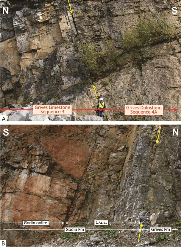
96- 5.6 m of a massive dolomite (‘lower dolomite’ of Kasig, 1980) correlated with the Hastière Fm by Kasig (1980) and Amler & Herbig (2006), most probably correlatable with the massive limestone of its middle member.
97- 6 m of shale of the Pont d’Arcole Fm.
98- 8 m of a cavernous dolomite (‘upper dolomite’ of Kasig, 1980, = Vesdre Fm of Amler & Herbig, 2006).
99- a marked palaeokarst surface (up to 2 m-deep) filled and overlain by a few metres of palisadic calcite and locally (e.g. Hastenrath quarry) by a 0.6 m-thick sandstone bed (Hastenrath Sandstone), marking the base of the Hastenrath Mbr (Amler & Herbig, 2006).
100- c. 10 m of oolitic grainstone (Vaughanites Oolite of Kasig, 1980). In the Hastenrath quarry, the lower part of the unit is a crinoidal grainstone with few oolites and the upper part an oolitic grainstone (Hastenrath Mbr of Amler & Herbig, 2006).
101- respectively c. 12 and 8 m of bioclastic limestone with crinoids (‘lower and upper cyclic succession’ of Kasig, 1980, = Bärenstein and Bernardshammer members of Amler & Herbig, 2006). The Bärenstein Mbr rests sharply on the Hastenrath Mbr and is separated from the overlying Bernardshammer Mbr by a marly breccia.
102- 35 to 40 m of oolitic grainstone (Amler & Herbig, 2006), ending with an erosive surface overlain by Namurian siltstone (Walhorn Beds of the Chokier Fm).
103A description and a biostratigraphy of these units were given by Kasig (1980) who considered them as extending from the lowermost Tournaisian (dolomitized Hastière Fm) to the upper part of the Livian (‘V3a’). Later, the succession was considered by Amler & Herbig (2006) and Aretz et al. (2006) as extending only up to the Neffe Fm. The study of rugose corals from the Hastenrath and Stolberg sections and their comparison with those of the Carnol quarry near Eupen especially for the Hastenrath Mbr and the revision of the lithostratigraphy lead to revise the ages of several units.
104The upper dolomite, was considered as ‘Tn2b’ and possibly ‘Tn3a’ (i.e. late Hastarian to earliest Ivorian) by Kasig (1980) and Amler & Herbig (2006) but corresponds to a part of the Landelies Fm as suggested by the underlying Pont d’Arcole Fm and the overlying Vaughanites Oolite.
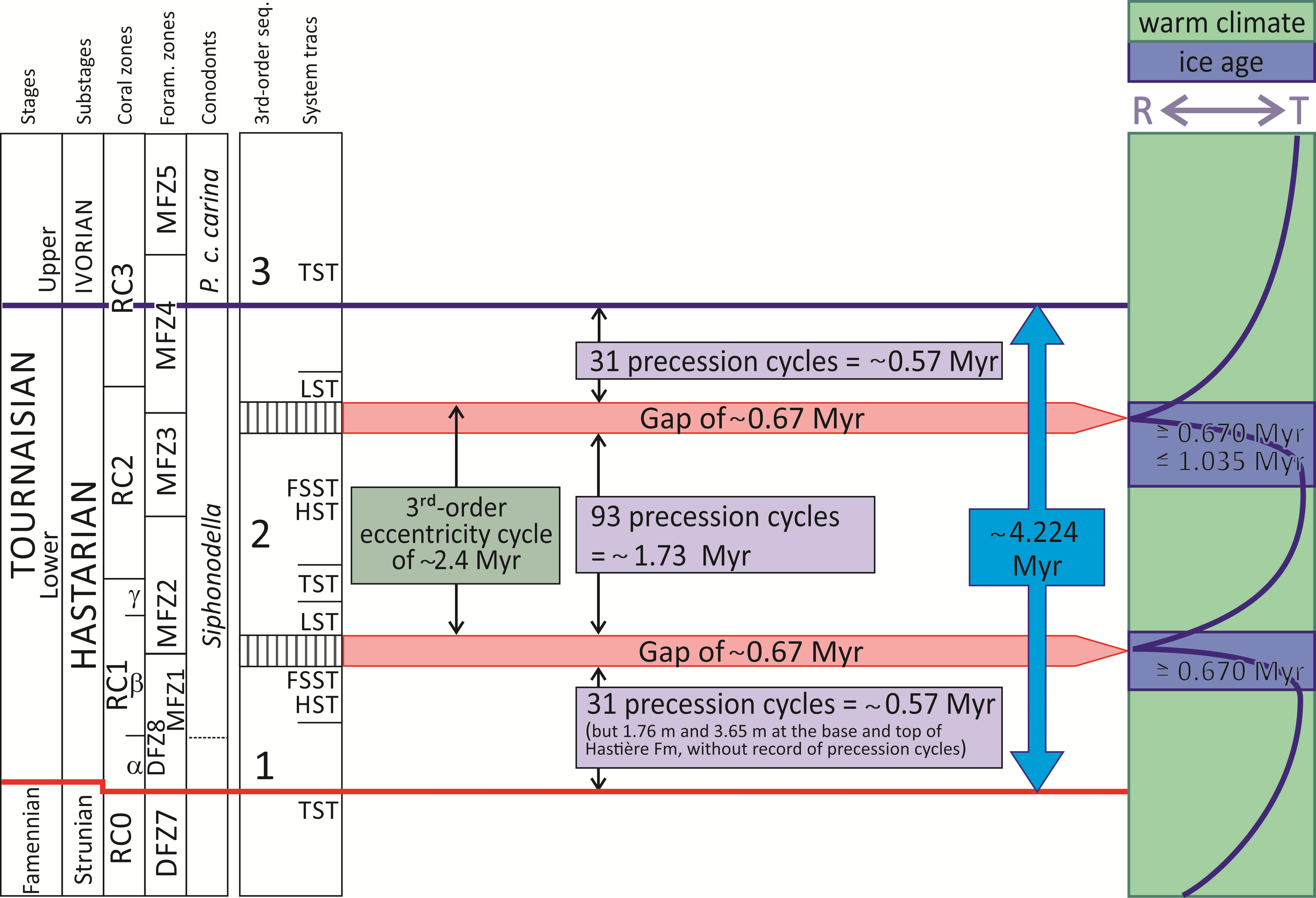
105The Hastenrath Mbr was considered as corresponding to the latest Tournaisian Avins Mbr (still considered as Early Viséan ‘V1a’ at this time) by Kasig (1980) and to the lower part of the Terwagne Fm by Amler & Herbig (2006). It yields Vaughanites flabelliformis and Uralinia cf. multiplex (Fig. 8B) indicating the top of the RC3 and/or the RC3 Coral Subzones of Poty et al. (2006). These corals allow the correlation with the oolitic, slightly dolomitized, limestone overlying the dolomitized Yvoir Fm in the Carnol quarry and therefore with the uppermost part of the Yvoir Fm and/or the Ourthe Fm. The basal few metres of palisadic calcite and sandstone filling the underlying palaeokarst indicate the beginning and delayed flooding during the third-order sequence 3 of the area.
106The Bärenstein and Bernardshammer members were considered as corresponding respectively to the Lower and Middle Viséan Neffe (‘V2a’) and Lives formations (‘V2b’) by Kasig (1980), and to the rest of the Terwagne Fm by Amler & Herbig (2006). In the Hastenrath quarry, the presence of Cyathoclisia modavensis in the Bernardshammer Member indicates the RC4 Subzone and hence, it allows a correlation with the Flémalle Mbr. The underlying Bärenstein Mbr, which is limited by sharp contacts, possibly could be correlated with the Martinrive Fm.
107The upper oolitic grainstone was considered as late Livian (‘V3a’) by Kasig (1980) and as corresponding to the late Moliniacian Neffe Fm by Amler & Herbig (2006). The record of Dorlodotia briarti (Weyer, 1994) confirms its correlation with the Neffe Fm, but its lower part possibly belongs to the Avins Mbr (Longpré Fm).
108Therefore, the carbonate succession in the Aachen area covers the Upper Tournaisian and the uppermost Lower Viséan Neffe Fm, which is directly overlain by Namurian siliciclastics. The stratigraphic position and the weak thickness of the recorded units (except for the youngest one) suggest numerous gaps and deposition only during times of high eustatic levels corresponding mainly to the HST of the third-order sequences.
3.4.3. Consequence: redefinition of the Vesdre – Aachen sedimentation area (VASA)
109The Vesdre and Aachen areas were first considered as belonging to the NSA (Hance et al., 2001), but Aretz et al. (2006) and Poty et al. (2011a), included them in a new distinct unit (VASA) because the sections near Aachen have a very incomplete Dinantian succession and limestone facies different from those known in the NSA. For the last authors, the Dinantian of the eastern part of the Vesdre area (Eupen vicinity) was supposed to be similar to that of the Aachen area and placed in the VASA. But as previously considered (Hance et al., 2001, 2002; Poty et al., 2002a), and shown here, the Dinantian succession in this area is closer to what is known in the central NSA (Marche-les-Dames, Engis). Hence, the VASA, as an individualized, very proximal, sedimentation area should be restricted only to the vicinity of Aachen (Fig. 1). The boundary between the NSA and VASA is situated between Eupen and Aachen.
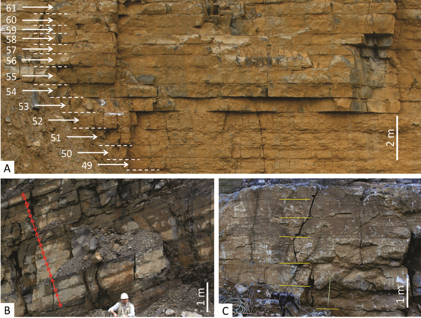
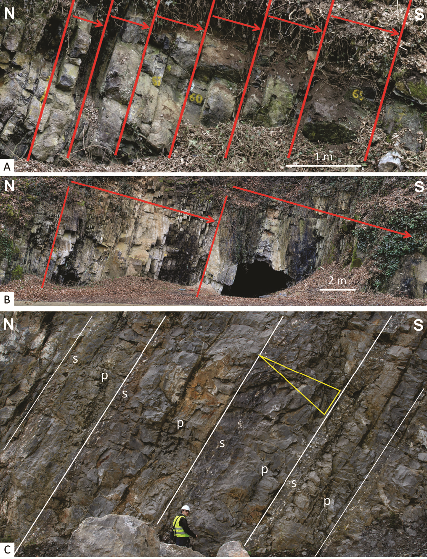
3.5. Tournaisian sequence stratigraphy in the South Avesnois sedimentation area (ASA)
110The ASA corresponds to the Avesnes ridge of Conil (in Mansy et al., 1989), but the northern Avesnois displays the same lithological units as the DSA (Hance et al., 2001) and is assimilated to the same sedimentation area. Until the Late Famennian, the southern Avesnois was characterized by distal environments (see 5.2), but during the Latest Famennian it shifted to shallower environments (see 5.3) as indicated by the deposition of the Etroeungt Limestone, succeeded by the Avesnelles Fm – equivalent to the lower and middle members of the Hastière Fm (Fig. 2). Its individualization from the DSA as a proximal area really started after deposition of the lower part of the Landelies Fm (Hastarian, sequence 2). In the Bocahut quarry (Godin), the lower part of the Landelies Fm is composed of 19 m of limestone with interbedded calcshale corresponding to well-marked precession cycles (Poty et al., 2013a; Denayer et al., 2015). The rest of the formation, which in the DSA corresponds mainly to the FSST of the sequence 2 for Poty et al. (2013a), is missing. The overlying Grives Fm is composed of two members:
111- A lower member of 17 m of fine-grained bioclastic grainstone, slightly dolomitized, in pluridecimetre- to metre-thick beds (Grives Limestone of Mansy et al., 1989), sharply resting on the Landelies Fm. Corals are common (Calmiussiphyllum cf. calmiussi, Caninophyllum patulum, Bifossularia cf. tictensis, Heterostrotion sp.) and indicate the top of the RC3 or the RC3 Zone. Foraminifers (CF2 Zone, Conil in Mansy et al., 1989, = MFZ5) suggest a correlation with the top of the Yvoir Fm and/or the Ourthe Fm (the latter being usually devoid of foraminifers and poor in corals). In other words, it corresponds to the end of the TST and/or the HST of sequence 3, as suggested by Hance et al. (2001).
112- An upper member (Grives Dolostone of Mansy et al., 1989), about 67 m-thick, composed of dolostone with calcite nodules (anhydrite pseudomorph), is separated from the lower member by a sharp contact (Fig. 9A). Its lower part belongs to the Dollymae bouckaerti conodont Zone (Mansy et al., 1989) and can be correlated with the Martinrive Fm (Hance et al., 2001). The sharp contact at the base of the member corresponds to the disconformity at the base of the sequence 4A, as observed in the CSA. The upper part of the member was dated as CF4 Foraminifer Zone (= MFZ7) and RC4 Zone in Mansy et al. (1989), and therefore correlated with the Flémalle Mbr of the Longpré Fm (Hance et al., 2001), i.e. the TST of sequence 4B.
113Figure 9. A: Disconformity (yellow arrows) between the Grives limestone member (left) and the Grives dolostone member (right), corresponding to the boundary between sequences 3 and 4A. Bocahut quarry, Godin, ASA; B:Disconformity (yellow arrows) between the Grives dolostone member (right) and the Godin Fm (left), corresponding to the sea-level fall reported at the base of the Avins Mbr. Abbreviation: C.G.E.: crinoidal grainstone with intercalated evaporitic levels pseudomorphosed in calcite, at the base of the Godin Fm. Bocahut quarry, Godin, ASA.
114The Godin Fm is 68 m-thick and essentially composed of oolitic grainstone. It is a thick lateral equivalent of the Avins Mbr (Mansy et al., 1989; Hance et al., 2001; Poty, 2007). Its base lies in disconformity on the top of the Grives Fm and is marked by a 1.5 to 3 m-thick unit of crinoidal grainstone with intercalated evaporitic levels pseudomorphosed in calcite (Fig. 9B). This disconformity corresponds to the minor eustatic fall and the emersion reported by Poty (2007) at the base of the Avins Mbr, which are more marked here. It could be correlated with a large-amplitude period of an obliquity modulation (see 4.1.1).
3.6. The transition between Condroz, Dinant and South Avesnois sedimentation areas (CSA, DSA, ASA)
115The DSA began to be individualized from the CSA and the ASA in the late Strunian, recording slightly deeper deposits. The major depositional change occurred in the late Hastarian, with the deposition of the Maurenne Fm in the southern part of the NDB (DSA), as the LST of the sequence 3, while the rest of the NDB was not yet flooded after the fall of the sea level at the end of the sequence 2 (Fig. 2). From that time, the DSA evolved to a trough (‘Auge dinantaise’) with the shape of a ramp inclined southwards (Hance et al., 2001, 2002). During the Ivorian, Waulsortian buildups and peri-Waulsortian facies (Bayard Fm) developed in its central and southern part, whereas the Leffe Fm developed in the north. At that time, the transition from DSA to CSA facies was relatively gradual, and there is not a well-defined boundary between the two areas (Paproth et al., 1983). On the other side, the boundary is clear-cut between the southern DSA and the ASA. Hence, there is no transitional facies between the Waulsortian complex of the DSA, developed in the north of the Avesnes area, and the corresponding Upper Tournaisian reduced series of the ASA (Grives Fm), suggesting a separation of the two areas by a narrow synsedimentary faulted zone (Fig. 10).
116In the Moliniacian of the southeasternmost part of the DSA, the Molignée Fm is overlain by the Hemptinne Fm (‘Terwagne blanc’), then by the Neffe Fm (e.g. in the Limont-Fontaine quarry near Maubeuge) (Figs 1, 2). The light-colour peritidal limestone of the Hemptinne Fm marks the lateral transition between the relatively confined facies of the Terwagne Fm (which is well developed in the ASA), and the open-marine Salet Fm of the DSA, symmetrically along both southern and northern borders of the DSA (Fig. 10). A similar succession is recorded along the southern limb of the Florennes Syncline (Hemptinne section), 30 km east of the north Avesnois, where dolomitized Waulsortian facies are directly overlain by the uppermost Ivorian Avins Mbr, then by the Hemptinne and Neffe formations. That indicates that the Hemptinne area was also close to, if not exactly on, the margin of the DSA and thus that the ASA extended eastward, outside the current outcropping area of the DSA, as already suggested by Paproth et al. (1983). Similarly, the occurrence of Waulsortian buildups in the Néblon valley near Hamoir (Lohest & Forir, 1902), allows extending eastward the northern boundary of the DSA (Fig. 1).
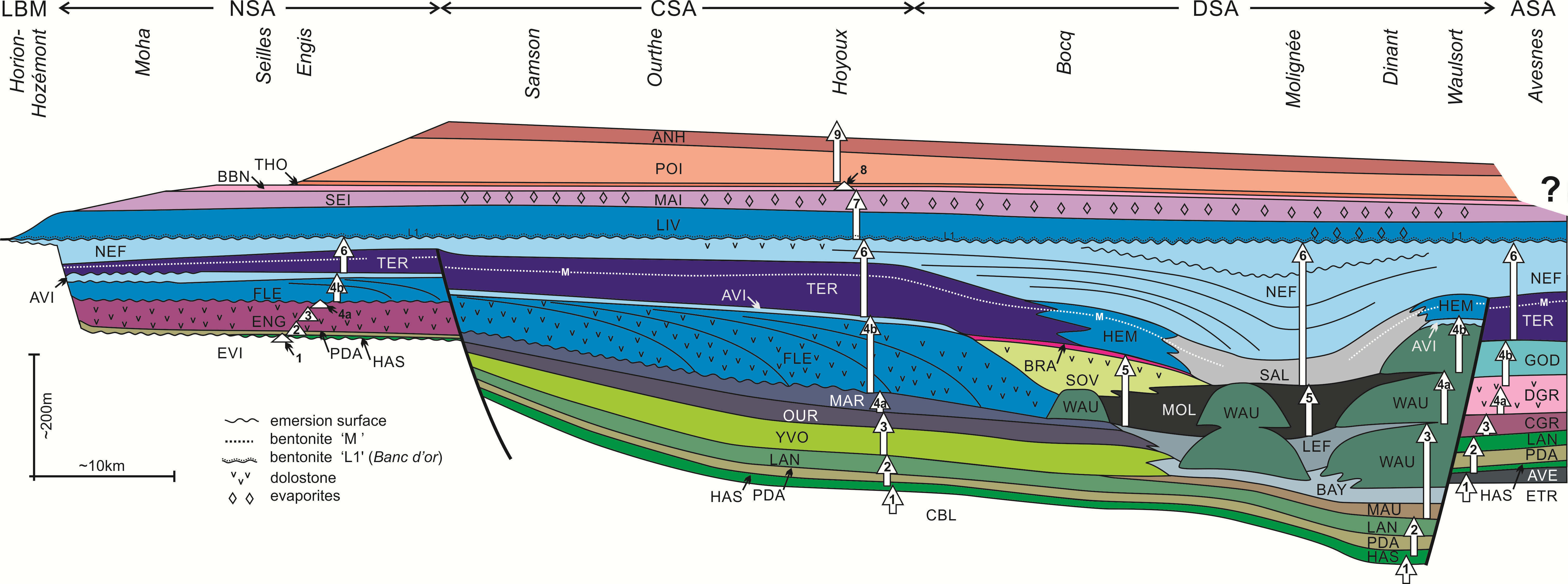
117Figure 10. Vertical and lateral organization of the ten Dinantian third-order sequences (white arrows) and resulting system tracts accross the Namur – Dinant Basin. Abbreviations: ANH: Anhée Fm, AVE: Avesnelles Fm, AVN: Avins Mbr, BAY: Bayard Fm, BBN: Bay-Bonnet Mbr, BRA: Braibant Mbr, CBL: Comblain-au-Pont Fm, CGR: Grives Limestone, CSA: Condroz sedimentation area, DGR: Grives Dolostone, DSA: Dinant sedimentation area, ENG: Engihoul Fm, ETR: Etroeungt Fm, EVI: Evieux Fm, FLE: Flémalle Mbr, GOD: Godin Fm, HAS: Hastière Fm, HEM: Hemptinne Fm, LAN: Landelies Fm, LEF: Leffe Fm, LIV: Lives Fm, MAI: Maizeret Mbr, MAR: Martinrive Fm, MAU: Maurenne Fm, MOL: Molignée Fm, NEF: Neffe Fm, NSA: Namur sedimentation area, OUR: Ourthe Fm, PDA: Pont d’Arcole Fm, POI: Poilvache Fm, SAL: Salet Fm, SEI: Seilles Mbr, SOV: Sovet Fm, TER: Terwagne Fm, THO: Thon-Samson Mbr, WAU: Waulsort Fm, YVO: Yvoir Fm. Modified from Poty et al. (2002a), with additions from Pirotte (2004). Scale indicative but not exact.
4. Orbitally-forced cycles in the Latest Devonian – Late Viséan interval and inferred climate reconstructions
118In the NDB, most Dinantian deposits show a more or less marked cyclicity. Overall, the organisation in ten third-order cycles governs the sedimentary patterns, but superimposed can be various shorter fourth- to sixth-order cycles. The third-order cycles have duration longer than 400 kyr (see below) and their composing units correspond usually to members and formations. The shorter cycles correspond respectively to the orbitally-forced eccentricity (400 kyr and 100 kyr), obliquity (40 kyr) and precession cycles (17 and 20.2 kyr for the Early Carboniferous, according to Berger et al., 1992), and appear as pluridecimetric to plurimetric strata assemblages.
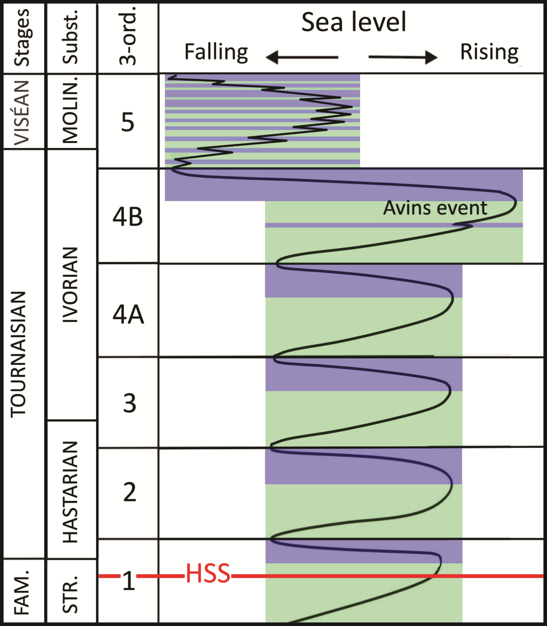
4.1. The long duration cycles (third-order sequences)
4.1.1. The duration of the third-order cycles
119Three Upper Viséan (upper Asbian and Brigantian) third-order cycles were calibrated in the Windsor Group in Nova Scotia, by determining the minor and major orbitally cycles, and using spectral analysis (Giles, 2009). The durations of the upper Asbian cycle (correlatable with the sequence 9 of Hance et al., 2001, 2002) and the two Brigantian cycles were respectively 2.33, 2.2 and 2.4 Myr. These durations are very close to the eccentricity period of 2.38 Myr (Laskar et al., 2004) and to the identical large-amplitude period of the obliquity modulation (2.38 Myr according to Beaufort, 1994). Giles (2009) recognized also the signals of the Beaufort (1994)’s additional obliquity modulation terms at 1.19 and 0.793 Myr, modulations being apparently unmarked in the eccentricity cycles.
120That duration of 2.38 Myr was also suggested for the Hastarian (Lower Tournaisian) sequence 2 of Hance et al. (2001, 2002), by the count of the precession cycles recorded in the DSA (Poty et al., 2013a) (Fig. 11). A rough comparison of the thicknesses of the calibrated sequences 2 and 9 in the NDB, with the mean thicknesses of the sequences 3, 4B, and 5, and additionally their (approximate) radiometric dating, suggest that probably their durations were similar and also close to 2.38 Myr. On the other hand, the same rough comparison with the sequences 7 (and 6?), 4A and 8 suggests that they could correspond respectively to the calculated obliquity modulation of 4.76 Myr, 1.19 Myr and 0.79 Myr of Beaufort (1994). These assumptions for the duration of these sequences have to be checked in the future.
121Figure 11. Time calibration of the Hastarian based on the count of the precession cycles and the supposed duration of the third-order sequences; and stratigraphic position of the two Hastarian periods with glaciations corresponding to the falling-stage system tracts (FSST) of the third-order sequences 1 and 2.
4.1.2. Glacio-eustatic origin of the third-order sequences
122During the Tournaisian and the Viséan, the third-order sequences recorded high variations of the sea level and long periods of emersion at their boundaries during the FSST and the LST (the duration of the emersion between sequences 1/2 and 2/3 was estimated to 0.67 Myr by Poty et al., 2013a; Fig. 11). Although their origin is not fully accepted, these sequences are most probably glacio-eustatic (Giles, 2009; Poty et al., 2015). Therefore, their transgressive and regressive phases can be correlated respectively to ice melt and ice formation on the continent. Hence, there were long-duration cycles with cold climate and ice formation and warmer climate with ice melt, which are distinct of the glacial-interglacial cycles related to the shorter eccentricity cycles (100 kyr) recorded in the Pleistocene (e.g. Rutherford & D'Hondt, 2000). During the Tournaisian, the long duration third-order orbitally-forced cycles are the dominant cause for the glacial-interglacial periods, the precession cycles having no real influence on the phenomenon (see 4.2.1). From the base of the Viséan onward (see 4.2.2), short glacial-interglacial cycles developed and became dominant, being integrated into the longer glacio-eustatic third-order cycles (Fig. 12). Therefore, there is a marked difference between the long glacial and interglacial cycles of the Tournaisian and the short and stronger glacial interglacial cycles of the Viséan, which are comparable to the Late Quaternary ones. Figure 12 gives a model of the succession of the glacial periods during the Tournaisian and the earliest Viséan in relation with the FSST of the third-order sequences.
123Figure 12. Strunian to earliest Viséan eustatic and climatic variations. In blue, sea-level falls probably corresponding to large ice caps formation; in green, sea-level rises probably corresponding to ice melt (warmer climate). Note the very high sea-level reached during the highstand system tract (HST) (Avins event) and the very low sea-level reached during the falling-stage system tract (FSST) of the sequence 4B. The Tournaisian ice ages are directed by the third-order cyclicity, whereas the Viséan glacial periods are directed by eccentricity cycles and the third-order cyclicity.
4.2. Short-duration cycles
124In Belgium, the short cycles were the first ones to be described: by Gérards (1955, unpublished) and Michot et al. (1963) in the Lives Fm (lower part of the Livian substage), then by Pirlet (1964a, 1968) in the Seilles Mbr (upper part of the Livian) and in the Warnantian. But at that time, the authors considered that they were the result of rhythmic subsidence motions or of opening and closing of the basin due to epeirogenic movements on a barrier (Pirlet, 1968), whereas their climatic and eustatic origins have been published only recently (e.g. Hennebert, 1996; Chevalier et al., 2006; Denayer et al., 2015).
4.2.1. Tournaisian orbitally-forced precession cycles
125Minor cycles are relatively well-marked in upper Strunian – Tournaisian interval (Poty et al., 2013b). The thickness of the cycles varies from about 0.2 m to 1 m, and is strongly influenced by the sediment production, the compaction of the argillaceous horizons, and the pressure dissolution in the limestone.Very demonstrative and well-exposed cycles can be observed in the Anseremme (Fig. 3) and Gendron-Celles sections (levels around the DCB in the upper Comblain-au-Pont Fm and Hastière Fm) and in the Nutons quarry at Chansin (upper member of the Hastière Fm, Pont d’Arcole, Landelies and Yvoir formations; Poty et al., 2011a; Denayer et al., 2015; Fig. 13).
126Figure 13. Precession cycles during the third-order sequence 2. A: cycles in the lower part of the Landelies Fm (HST sequence 2), numbers refer to their position within the sequence; B: cycles in the Pont d’Arcole Fm (TST sequence 2); C: cycles in the upper part of the Landelies Fm (FSST sequence 2), here cycles are truncated, indicating an emersion due to a low sea-level variation. Les Nutons quarry at Chansin (Spontin), DSA.
127In the upper Comblain-au-Pont Fm (uppermost Strunian) and in the lower and upper members of the Hastière Fm (lower Hastarian), these cycles correspond typically to shale and limestone alternations and were first described by Van Steenwinkel (1990). They evolved into alternations of shale and calcareous shale in the Pont d’Arcole Fm (Fig. 13B), then again to alternations of calcareous shale and limestone in the lower part of the Landelies Fm (Fig. 13A), and to limestone bed with sharp contacts in the upper part of the Landelies Fm (Fig. 13C). In the Hun Mbr of the Yvoir Fm, cycles are typically calcshale-limestone doublets, then regular limestone beds in the rest of the Yvoir Fm.
128Interestingly, the sedimentary composition and pattern within individual cycle change in parallel with the depositional evolution of the third-order sequences. Among the first three sequences of Hance et al. (2001), several trends are noted:
129(1) truncations at the top of cycles can occur during the LST or early TST and the FFST, indicating emersion. Cycles are however not truncated during the rest of the TST and the HST, suggesting relatively low eustatic variations not exceeding a few metres.
130(2) During sequence 2, the ratio clay/limestone increases from the LST (upper member of the Hastière Fm) to the maximum flooding zone (middle part of the Pont d’Arcole Fm), then decreases to the top of the HST (top of the lower member of the Landelies Fm), and become zero in the FSST (upper member of the Landelies Fm). A similar trend occurs in sequences 1 and 3, but is less demonstrative. Such features indicate that the cycles are mainly due to alternations of wet-dry climates: argillaceous inputs indicate enhanced weathering allowed by wet climate and conversely, purer limestone deposition indicates dry climate with few or no weathering (Reading & Levell, 1996).
131(3) Above the Yvoir Fm, the Ivorian is essentially composed of limestone. Cycles correspond to decimetre- to metre-thick limestone beds with thin, more or less argillaceous, interbeds, and are not so easily recognizable. However they can be locally well developed, as in the Salet road section or in the Upper Tournaisian of the Tournai area (Hennebert, 1996).
132In the NDB, the Hastarian minor cycles do not seem to be grouped in bundles and recorded one single orbital parameter. Because of their relatively regular distribution, their thickness, and abundance, they are considered as corresponding to orbitally-forced precession cycles of about 17 and 20.2 kyr (18.6 kyr on a rough average duration), according to Berger et al. (1992), as those of the Upper Tournaisian of Tournai described by Hennebert (1996).
133An attempt of calibration of the Hastarian was realized by Poty et al. (2013a), using the precession cycles and the third-order sequences, which, according to Giles (2009), could correspond to eccentricity cycles of 2.4 Myr. Poty et al. (2013a) obtain 4.224 Myr as a possible duration for the Hastarian (Fig. 11). Note that, according to Menning et al. (2001), the Hastarian lasted c. 6 Myr.
4.2.2. Viséan parasequences
134Unlike the Tournaisian, the Viséan recorded shallowing-upward sequences with sharp boundaries corresponding typically to characteristic parasequences. The latter are thicker (metric to plurimetric) and more variable than the Tournaisian cycles. Pattern and thicknesses seem to indicate that they correspond mainly to eccentricity glacio-eustatic parasequences (c. 100 and 400 kyr), possibly modulated by precession (c. 18.6 kyr) and obliquity (c. 40 kyr) orbitally-forced cycles. Traditionally (e.g. Wright & Vanstone, 2001), it was considered that parasequences did not appear before the Upper Viséan. However, in Belgium, they are present and well developed from the base of the Viséan (Poty et al., 2013b; Fig. 14) and during the entire stage (see Mottequin, 2004, for the lower Moliniacian; Maes et al., 1989, for the upper Moliniacian; Michot et al., 1963 and Chevalier et al., 2006, for the Livian; Pirlet, 1968, Poty et al., 1988, and Aretz, 2001, for the Warnantian).
135Figure 14. Shift between the Tournaisian precession-dominant cyclicity and the Viséan eccentricity glacio-eustacy. A: precession cycles in the uppermost Tournaisian Leffe Fm; B: eccentricity parasequences in the lowermost Viséan Molignée Fm (strata are overturned), Salet road section, DSA; C: Glacio-eustatic shallowing-upward parasequences in the Lower Viséan Terwagne Fm. Legend: p: thick lower part of the sequences composed of bioclastic packstone; s: thin upper part composed of stromatolitic facies with anhydrite nodules pseudomorphosed in calcite, Bocahut quarry, Godin, ASA.
136Whereas the Tournaisian cycles were mainly the result of precession climatic variations, with weak eustatic amplitude, the Viséan ones mainly correspond to important sea-level variations with estimated amplitudes >20 m. For example, in most Livian shallowing-upward parasequences, the sediments of the base are wackestone to packstone with a rich open marine fauna, typically deposited under the fair-weather wave base, whereas the top deposits are intertidal to supratidal mudstone and stromatolitic boundstone, ending with an emersion surface. These parasequences, 3 to 4 m-thick, perfectly indicate the large bathymetric gradient within facies.
4.3. From highest to lowest relative global sea level across the Tournaisian – Viséan Boundary
4.3.1. The Avins event
137The sequence 4B recorded a very high rise of the global sea level during its HST (Avins event of Poty, 2007, after the eponymous member of the Longpré Fm) (Fig. 12), that triggered the flooding of previously emerged lowlands where no Tournaisian deposits were known, e.g. in the Laval Basin (France, Pelhate et al., 1991), in New South Wales (Australia, Pickett, 1966) and on the Akiyoshi Plateau (Japan, Haikawa, 1986). It also allowed connections between distant and/or isolated areas, as well as widespread migrations and mixing of faunas. The deposits recording this event – commonly oolitic – are traced throughout Eurasia and as far as China, Japan and Australia (Poty, 2007). In Belgium, it is well developed in the shallow-water environments, but it is not well expressed in the deeper DSA (Hance et al., 2001; Devuyst, 2006), except on top of some Waulsortian mounds (Fig. 10).
4.3.2. The drop of the sea level at the end of the sequence 4B and the cyclicity change
138The Avins ‘highest-stand’ system tract was followed by a very strong sea-level fall during the FSST (Fig. 12), much more intense than those of the FSST of the previous Tournaisian sequences (Hance et al., 2001, 2002). It caused the emergence of the shallow sedimentation areas (NSA, CSA, ASA, VASA), and ended the growth of the Waulsortian buildups in the deeper DSA. After Lees (1997), this sea-level fall was about 140 m. It is correlated with the shift from the Tournaisian precession cycles pattern to the Viséan eccentricity eustatic parasequences pattern. This transition is nicely exposed in the Salet road section (DSA). In the lower part of the section, in the Leffe Fm, the cyclicity is first dominated by precession, pluridecimetre-thick cycles (Fig. 14A), then, in the upper part of Leffe to Molignée formations, by thicker obliquity cycles with a precession influence. Finally, the upper part of the Molignée Fm is composed by plurimetre-thick eccentricity parasequences with influence of obliquity and (?) precession (Fig. 14B; Mottequin, 2004; Poty et al., 2013b; Denayer et al., 2015).
139This sea-level drop was so considerable that the rise of the sea level during the following third-order sequence 5 was not high enough to reach the shallow marine platforms previously covered by the latest Tournaisian sea. Hence, in the NDB, sequence 5 is only developed in the DSA (Hance et al., 2001, 2002) (Fig. 10).
140The sea level drop and the gap of the sequence 5 in the shallow marine areas are not recorded only in the NDB, but in most shelf settings (Devuyst, 2006; Bábek et al., 2010), and explain the difficulties of the previous correlations around the Tournaisian – Viséan Boundary (Conil et al., 1989), the base of the Viséan being situated within the lower part of sequence 5 (Hance et al., 2001, 2002). In deep basinal settings, the earliest Viséan low sea-level is recorded by the development of carbonate deposits replacing pelitic deposits, such as in Montagne noire (Faugères Fm, Aretz, 2016, this volume) or in the Rhenish Kulm Basin (Erdbach Limestone III, Herbig, 2016, this volume).
141The latest Tournaisian very high sea level (Avins event) most probably corresponds to a maximum deglaciation phase and thus to a minimal development of continental ice. The following strong fall in the sea level is considered to correspond to the development of a wide ice cap and to a heralding change to the Carboniferous climate with major glaciations on Gondwana (Bábek et al., 2013; Poty et al., 2013a). As the sea never reached the previous shallow marine shelves, even during the HST of the sequence 5, it should indicate that the sea did not regain its previous level, suggesting that a large ice cap persisted from this time. The flooding of the shallow shelfs from the sequence 6 could result from the subsidence balance (see 5.6.) (Fig. 10).
142Therefore the onset of the strong Carboniferous glaciations, marked by both the glacio-eustatic parasequences and the development of a large ice cap, was as early as the Early Viséan (Poty et al., 2013a) and not the Late Viséan or the Serpukhovian as usually considered (e.g. Wright & Vanstone, 2001; Isbell et al., 2003; Fielding et al., 2008; Barham et al., 2012).
4.3.3. Consequences
143Beside the obvious change in geometry and thickness, the distinct Tournaisian and Viséan cycles and their link with different climatic patterns had very strong consequences on the deposition and the evolution of the NDB.
144(1) During the Tournaisian, the sedimentation is influenced mainly by the alternation of monsoon/dry climate precession cycles (Fig. 14A-B). There was thus few influence on the depth of the marine environments, which remained relatively constant on a short period, but changed slowly following the long duration third-order cycles. So, the NDB remained open and was only restricted or emerged during the end of the FSST and the LST of the third-order sequences.
145(2) During the Viséan, the sedimentation was mainly influenced by the eustatic variations, giving rise to parasequences (Fig. 14C). The high range of variation of the depth in the shallowing-upward cycles caused short alternations of flooding and emersion of the platform. For example, in the parasequences composing the LST-TST of the sequence 7 (Livian) and 9 (lower Warnantian), the restricted, mainly stromatolitic and supratidal facies became dominant and a final emersion affected the entire basin each time. As for the Tournaisian, the evolution of parasequences follows the third-order cycles.
5. Evolution of the depocenter in the NDB during Dinantian times
5.1. General overview
146The seven tectono-sedimentary areas recognized in the NDB (Figs 1, 2) are obviously linked to its global tectonic evolution. Thus, the onset of the NSA shelf (and the further west HSA) is directly related to the onset of the Campine Basin, both corresponding to a system of tilted blocks forming ramp-like half-grabens, north and south of the Brabant Peninsula (Poty, 1997; McCann et al., 2008). The evolution of the DSA into a trough during the Late Tournaisian could be seen as the development of a foreland basin linked to the onset of the Ardennian phase of the Variscan Orogeny, which later moved northwards to the CSA and NSA (see below).
147Indeed, the thickest and most distal Lower Devonian deposits are observed in the southernmost zone of present outcrop of the NDB, i.e. the Neufchâteau Synclinorium. Consecutively, the most distal and thickest Middle and Upper Devonian deposits are situated on the southern margin of the Dinant Synclinorium.
148The northward progression of the depocenter started during the Devonian and continued throughout the Carboniferous until the basin was entirely filled with the Upper Carboniferous molasse (Fourmarier, 1954).
149If the big picture of the NDB evolution is well established, the detailed succession in the Dinantian required detailed explanations as presented in the following points.
5.2. The Mid-Late Famennian pattern
150The most distal and open-marine facies of the Middle and Upper Famennian (rhomboidea to Middle expansa conodont zones), succeeding to the shaly Famenne Fm (Lower triangularis to Uppermost crepida), are exposed in the ASA, on the southwestern border of the Dinant Synclinorium. Further south, they are not preserved because of their erosion. They corresponds to the shaly Sains Fm, which comprises some calcareous intercalations (lateral equivalent of the Souverain-Pré Fm), and to the shaly Epinette Fm (Thorez et al., 2006). These distal marine facies are considered as being open towards the Rhenohercynian (Cornwall – Rhenish) Basin (Paproth et al., 1986; Thorez et al., 2006). In contrast, all other parts of the NDB show more proximal successions with dominant siltstone and sandstone deposits (Condroz Sandstone Group, Thorez et al., 2006).
5.3. Latest Famennian
151During the Uppermost Famennian (Strunian Substage, Upper expansa to praesulcata), in the ASA, the transition from shale-dominated marine facies (Epinette Fm) to alternation of shale and limestone (lower part of the Etroeungt Fm sensu lato) then to shallow-water grainstone (Etroeungt Fm sensu stricto) indicates a shallowing-upward. The reverse situation is observed in the southern part of the DSA, where a relative deepening marked the Strunian and reached its maximum at the end of the substage (e.g. in the Anseremme and Gendron-Celles sections), where the upper part of the Strunian is characterized by a cyclic alternation of limestone and shale deposited below the fair-weather wave zone (Van Steenwinkel, 1990; Poty et al., 2015).
152This indicates that the deepest area, i.e. the depocenter, had migrated to the DSA at the end of the Devonian (Fig. 10). This northward migration of the depocenter could correspond to a step in the collisional stage of the Variscan orogeny related to the closure of the Rhenohercynian Ocean, and the beginning of the emersion of the Ardennes region. From this time onward, the NDB was probably edged southwards by an emerged land or a high and not open to a deep (Kulm) basin, as westward in southwestern England (Waters et al., 2011) and eastward in the western Germany (Herbig, 2016, this volume).
5.4. Hastarian
153The shallowing trend of the ASA is less marked in the early Hastarian with a Pont d’Arcole Fm curiously thicker (30 m-thick) than in the DSA (about 12 m near Dinant). In the CSA and DSA, the late Hastarian Landelies Fm, developing on a ramp slightly inclined southward, is 35 to 40 m-thick, whereas in the ASA, the only 19 m-thick formation is more argillaceous (e.g. in the Bocahut quarry). This shift marked the decrease of the subsidence rate in the ASA and its subsequent evolution as a distinct sedimentation area with thinner shallow deposits and gaps.
154The limestone of the Landelies Fm emerged everywhere during the FSST of the sequence 2 and were locally affected by a dolomitization in the nearshore zones (complete dolomitization in the NSA and VASA, limited to its upper part in the CSA).
155The subsidence rate in the DSA probably increased sharply from the latest Hastarian, as indicated by the record of the LST of the sequence 3 (Maurenne Fm), which lacks in the other areas (Fig. 10).
5.5. Ivorian: the Dinant trough
156From the Ivorian, clear differences in facies appear throughout the NDB as noted by previous researchers (e.g. Paproth et al., 1983). Notably, the DSA evolved into a trough (‘Auge dinantaise’ of Conil in Robaszynski & Dupuis, 1983), with the shape of a ramp inclined southward (Hance et al., 2001, 2002), in which developed deeper marine facies and Waulsortian mounds until the top of the Tournaisian. From that time, the rate of subsidence of the DSA decreased, and the trough was progressively filled and had disappeared by the end of the Moliniacian (Hance et al., 2001, 2002).
5.6. Moliniacian: the filling of the Dinant trough
157The earliest Viséan sequence 5 flooded only the DSA, where the first parasequences have been recorded in the ‘Black Marble’ of the Molignée Fm, as alternations of open marine and lagoonal facies (see 4.3.). These deposits progressively filled the Dinant trough between the deceased Waulsortian highs and levelled out facies differences between the southern and northern DSA. On the northern slope of the trough, the Molignée Fm passes laterally to shallower open marine partly dolomitized bioclastic packstone and grainstone of the Sovet Fm (Fig. 10).
158The rise of the sea level at the beginning of the sequence 6 flooded firstly the DSA, which still formed a shallow depression. In the central DSA (e.g. in the Tanret quarry at Salet), the dolomitized top of the Molignée Fm is overlain disconformably by four metres of bioclastic sedimentary breccia (debris flow; base of the Salet Fm), which corresponds to the FSST of sequence 5 and LST of sequence 6 (Figs 15, 4B). The TST includes c. 10 m of oolitic grainstone, then bioclastic packstone and grainstone, the last ones composing the major part of the Salet Fm. Northward and southward on the edges of the DSA, the Salet Fm passes laterally to shallower subtidal facies (Hemptinne Fm), then in the CSA and the ASA to peritidal to supratidal limestone with some palaeosols (Terwagne Fm, Fig. 15), onlapping progressively the two areas, and finally the NSA (Fig. 10). The Terwagne Fm rests paraconformably on the top of the sequence 4B. Thereby, its thickness passes from c. 100 m in its type section in the CSA to 50 m in the Marche-les-Dames area (central NSA) and 30 m in the Engis area in the eastern NSA, these 30 m being well correlated by biostratigraphy (corals) and a volcanic ash level (cinerite ‘M’ of Delcambre, 1989) with the upper part of the formation (Fig. 10).
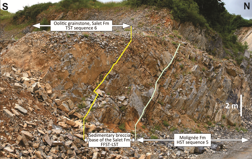
159Figure 15. Disconformity (green line) between the dolomitized top of the Molignée Fm and the sedimentary breccia marking the base of the Salet Fm. The latter is considered as corresponding to the boundary between the highstand system tract (HST) of the sequence 5 and a falling-stage to lowstand system tract (FSST-LST). The overlying oolitic limestone marks the base of the transgressive system tract (TST) of the sequence 6, Tanret quarry, Salet, DSA.
160The flooding of the CSA, NSA and ASA during sequence 6 could suggest a rise of the sea level higher than for the previous sequence. However, during the sequence 5, the subsidence was still active in the entire basin and provoked the lowering of both the flooded and emerged areas. During the Ivorian (sequences 3 and 4) and the late Moliniacian (sequence 6), the subsidence of the CSA was roughly c. 30 m per Myr (inferred from the total thickness of the Upper Tournaisian and Lower Viséan deposits divided by their duration). It was similar in the DSA for all the Moliniacian. Therefore, if the duration of the sequence 5 corresponded to an eccentricity cycle of 2.4 Myr, the emerged CSA surface could have been c. 75 m below its previous height, and probably 10 to 20 m more by the time the sequence 6 invaded it. This supports a sea-level drop persisting for the rest of the Viséan (see 4.3.), and eustatic variations of the Viséan third-order sequences looking like the Tournaisian ones, but with a lower base level.
161The Neffe Fm, which corresponds to the HST and the FSST of the sequence 6, was highly progradational and definitively filled and smoothed out the Dinant trough (Fig. 10; Hance et al., 2001, 2002; Pirotte, 2004). The formation is capped by the ‘Banc d’or de Bachant’, a pedogenetized volcanic ash layer (cinerite ‘L1’ of Delcambre, 1989), which records its emersion and marks the sequence boundary with sequence 7.
5.7. Livian
162From the early Livian (Lives Fm), the subsidence became higher and the marine facies more open in the CSA, and even more in the NSA, than in the DSA, indicating a reversal in the basin geometry. In the NSA and the CSA, the LST of the sequence 7 (Haut-le-Wastia Mbr) is characterized by shallowing-upward parasequences divided into a lower thin open marine facies and upper dominantly stromatolitic and supratidal facies, whereas in the DSA, parasequences with basal stromatolites and upper supratidal and evaporitic facies developed. The dissolution of these evaporites resulted in collapse breccias (‘Petite Brèche viséenne’ of previous authors, e.g. Mortelmans & Bourguignon, 1954; Fig. 10). During the TST of sequence 7 (Corphalies and Awirs members of the Lives Fm), subtidal open-marine facies became dominant in the parasequences, in the NSA and CSA, whereas stromatolitic and supratidal facies decreased, then finally disappeared (upper part of the Awirs Mbr). In contrast, in the DSA (e.g. in the Leffe quarry near Dinant), stromatolitic and supratidal facies continued to dominate the parasequences, resulting in local minor solution collapse breccia levels.
163Subsidence seemingly increased in the eastern part of the NSA during the late Livian (Seilles Mbr, HST of the sequence 7), illustrated by the increasing thickness from west to east (Seilles quarry: 40 m, Engihoul quarry: 55 m, Bay-Bonnet quarry: 70 m). The shallowing-upward parasequences remained dominated by shallow open-marine facies (bioclastic packstone and grainstone) in this eastern area. Simultaneously, almost everywhere in the rest of the basin (western part of the NSA, HSA, CSA, DSA and ASA), evaporites developed. It is particularly true in the HSA where the Saint-Ghislain borehole crossed about 120 m of anhydrite (De Putter et al., 1991). However, no late Livian evaporites are known either from the VSA, which was separated from the NDB at this time, nor from the VASA, where the Livian is missing.
164The dissolution of these late Livian evaporites triggered the formation of the ‘Grande Brèche viséenne’ (Mamet et al., 1986), either shortly after their deposition and only a small part of the overlying levels collapsed, or after a variously longer time and the collapse affected the entire overlying Viséan strata. In that case, some non-brecciated rafts up to several tens of metres-thick and several hundred metres-wide are preserved in the breccia.
165The transition between the bioclastic-dominant parasequences of the Seilles Mbr and the solution collapse breccia can be observed in the Maizeret Mbr (Grands Malades Fm) in the disused Plates Escailles quarry at Maizeret (Brasseur, 1996; Devuyst et al., 2005). The Maizeret Mbr is the lateral stratigraphic equivalent of the Seilles Mbr (Fig. 16); it is a 37 m-thick unit of shallowing-upwards parasequences mainly with basal microbial boundstone and mudstone, and upper levels of gypsum or anhydrite pseudomorphosed in calcite, sometimes brecciated and/or dolomitized. 1.5 km southeast (Sur les Forges disused quarry), the Maizeret Mbr is entirely brecciated (Pirlet, 1968; Brasseur, 1996; Devuyst et al., 2005), suggesting that the original evaporitic levels were thicker (Fig. 16).
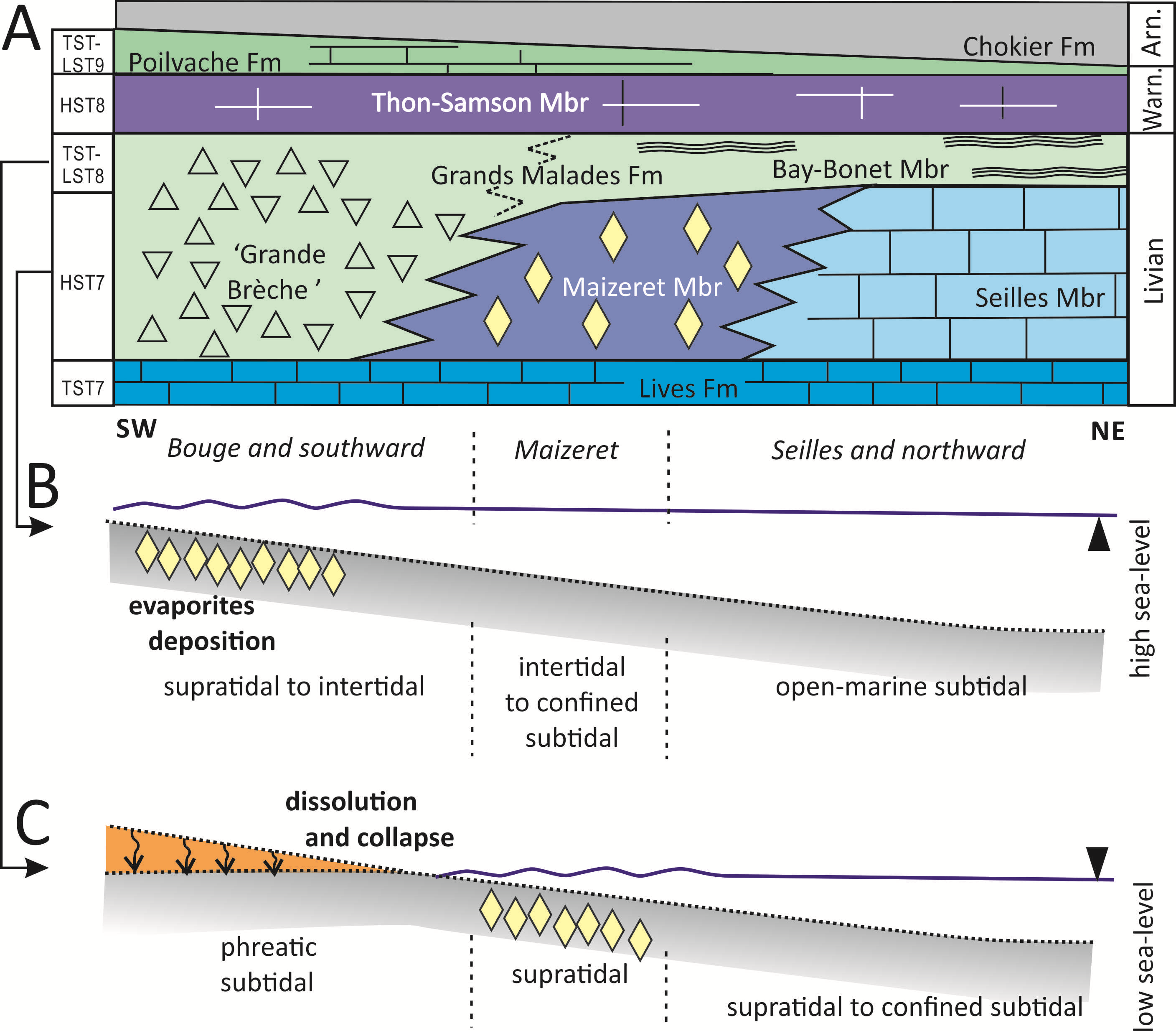
166Figure 16. Lateral variation within the Livian and mode of formation of the ‘Grande Brèche viséenne’ collapse breccia A: SW-NE lateral facies variations within the upper Livian Grands Malades Fm, between Namur (SW) and Seilles (NE). B-C: lateral variations in the upper Livian (Grands Malades Fm) parasequences between the SW restricted evaporitic facies (Plates-Escailles quarry) and the NE open marine environments of the Seilles Mbr, through the Maizeret Mbr facies. The solution-collapse of the evaporitic facies gave rise to the ‘Grande Brèche viséenne’.
167During the development of the short sequence 8, the NDB evolved into a relatively homogeneous inner platform. LST and TST (uppermost Livian Bay-Bonnet Mbr of the Grands Malades Fm) are characterized by restricted stromatolitic facies whereas HST-FSST (basal Warnantian Thon-Samson Mbr of the Bonne River Fm) was dominated by open-marine shallow-water crinoidal grainstone rich in foraminifers and corals (including the markers of the Warnantian Substage; Poty & Hance, 2006; Poty et al., 2014).
5.8. Warnantian
168The lower Warnantian (LST-TST of the sequence 9) comprises shallowing-upward parasequences mainly composed of microbialites and intertidal to supratidal limestone, with very few marine bioclastic levels, in the entire NDB (Poilvache Mbr in CSA, DSA and locally NSA; part of the Viesville Fm in HSA; middle unit of the Joinville Fm in the Boulonnais). It indicates a large relatively homogeneous restricted inner platform, which was only occasionally open to the open-marine sea towards the west.
169In the upper part of the lower Warnantian and in the basal upper Warnantian (lower Mbr of the Anhée Fm, HST of the sequence 9; late Asbian and base of the Brigantian of the British authors), shallowing-upward parasequences remained very well expressed in the CSA, with dominant well-developed open-marine facies in their lower part, and usually stromatolitic facies at their top. In some localities, such as Royseux (Chabôfosse Facies, Poty et al., 2002a) in the Hoyoux valley (Pirlet, 1964b; Poty, 1981), or in the Leulinghen-Bernes quarry in the Boulonnais (NSA; Poty & Hannay, 1994), the open marine facies in the lower part of the parasequences are mainly composed of packstone, grainstone and rugose coral biostromes yielding a rich fauna (Poty, 1981; Aretz, 2001; Denayer et al., 2011; Denayer et al., 2016, this volume). Conversely, most of the deposits known in the NSA, DSA and CSA are composed of mudstone, wackestone and packstone poor in macrofossils.
170The fossiliferous areas seem to correspond to small shallow-water pools (due to local several metres-scaled block faulting?), as suggested by the rapid lithological changes between closed sections at Royseux (CSA, Hoyoux valley), and by the presence of an irregular intraformational conglomerate (Poty et al., 1988; Aretz, 2001; Denayer et al., 2016, this volume).
171Note that in the VSA, a similar rich macrofauna developed in a shallow-water microbial reef (Visé, quarry ‘F’, Muchez & Peeters, 1987; Aretz & Chevalier, 2007), whereas the surrounding limestone remained relatively poor in macrofossils. These levels yielded the classical Visé fossil fauna (Pirlet, 1967) that filled the drawers of museums since the 19th century.
172The rest of the upper Warnantian (British Brigantian substage of George et al., 1976) is poorly recorded in the NDB. In the DSA and CSA, it is only composed by argillaceous limestone, shale and lydite of the upper Mbr of the Anhée Fm (= upper Mbr of the Warnant Fm of Paproth et al., 1983; 8 m-thick or less). Note that similar deposits in the western HSA are much thicker (Blaton and Gottignies formations; c. 130 m after Hennebert, 1999).
173These levels mark the end of the Namur-Dinant Viséan platform, and it is possible that at this time, the subsidence was almost insignificant despite the fact that a shallow-water sea could still exist, but without significant sedimentary record (Fig. 2). Finally, the NDB emerged with the sea-level drop after an accentuation of the buildup of ice caps, around the Viséan – Namurian Boundary (e.g. Isbel et al., 2003). The emersion of the NDB at the end of the Viséan produced locally palaeokarsts, up to 100 m deep, for example at Seilles, in the NSA (Fig. 17A; Devuyst et al., 2005). Similar palaeokarsts of common origin were also recorded for example at Argenteau, in the VSA (Fig. 18, Poty & Delculée, 2011), at the top of the Viséan in the French Montagne Noire (Poty et al., 2002b) and in NW Turkey (Denayer, 2014).
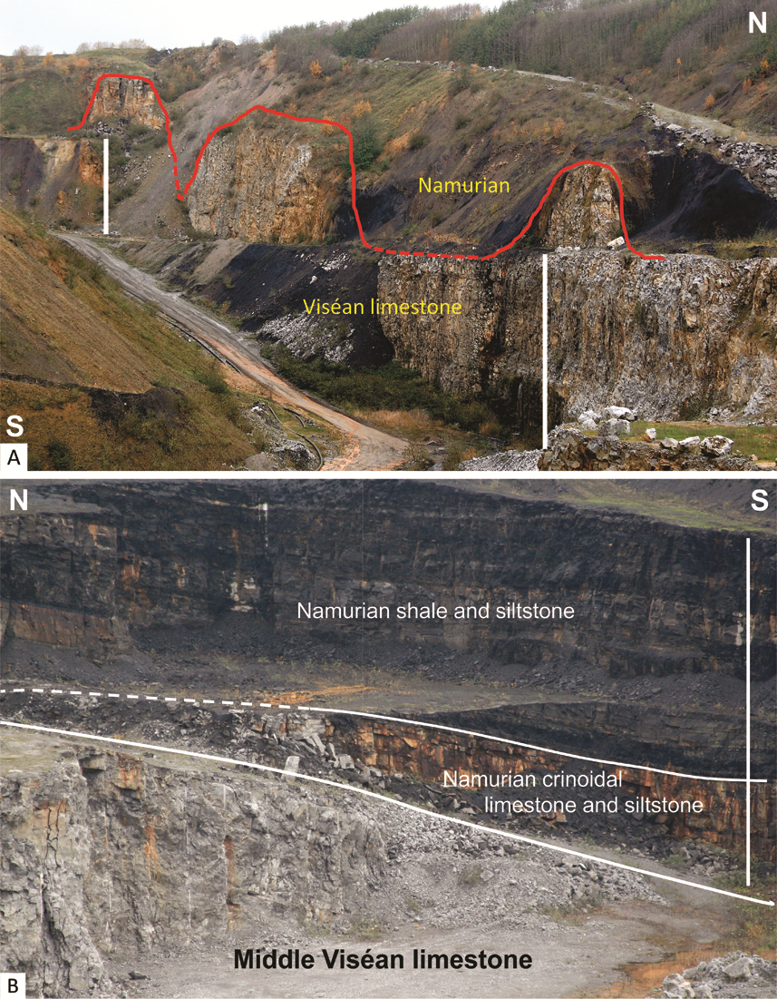
174Figure 17. Palaeokarsts developed at the end of the Viséan. A: Palaeokarst affecting the Grands Malades Fm and the Poilvache Mbr (red line), resulting of a strong sea-level fall associated to the change to the Namurian climate with strongest glaciation periods. The karstic depressions were filled with lower Namurian deposits. Note that locally some later dissolutions collapse the Namurian deposits, Seilles quarry, NSA. White bars are 20 m high; B:lower Namurian crinoidal Tramaka Mbr (lower part of the Chokier Fm) resting on the Viséan karstic-abrasion surface, and overlain by the dark shale and siltstone of the Chokier Fm. Seilles quarry, NSA.
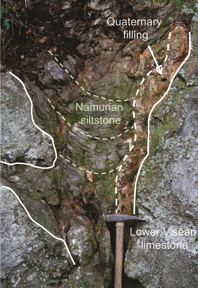
175Figure 18. Karstic cavity developed in Lower Viséan limestone at the end of the Viséan, and filled with Namurian siltstone. The cave was situated at least 100 m below the top of the Viséan limestone. A recent reactivation of the karst was filled by collapsed Quaternary fluvial deposits, Argenteau Rock, VSA (hammer for scale).
5.9. Serpukhovian: burying the Dinantian platform
176The first Namurian deposits (Chokier Fm) are mainly composed of black shale interbedded with siltstone, sandstone and locally crinoidal rudstone (Tramaka Mbr, Austin et al., 1974; Paproth et al., 1983; Fig. 17B). The siltstone and sandstone form usually channels in which plant remains can be present, such as in the Engihoul quarry, where a large channel interbedded in black shales contains large fragments of Lepidodendron, Sigillaria, Cordaites, Calamites and Artisia. All these deposits correspond typically to coastal shallow subtidal environments (Tramaka crinoidal limestone) to distal delta lobes (Nyhuis et al., 2014). The Chokier Fm is diachronic and its base extends from Arnsbergian (e.g. in Seilles, Bouckaert & Lambrecht, 1967) to Chokierian (e.g. in Engis, Bouckaert, 1967). Since most of the Pendleian is lacking, the Tramaka Mbr being possibly latest Pendleian (Delmer et al., 2001).
177In Seilles and Visé, these deposits fill the palaeokarsts developed in the Viséan limestone, but in most localities of the NSA (e.g. Engihoul quarry), they lie in paraconformity on a flat abrasion surface at the top of the Livian or at the base of the Warnantian, the rest of the Upper Viséan formations being eroded and missing (Pirlet, 1968). The Namurian depocenter was clearly situated in the NSA (and HSA) and northward, and is linked to the development of the foreland basin in front of the Ardenne Orogeny, as indicated by the input of detrital sediments from the now emerged Ardenne area (Fourmarier, 1954).
6. Conclusions
178The availability of long sections such as those allowing to cross a continuous succession of deposits, and the precision currently obtained by combining the litho-, bio- and sequence stratigraphy, in the Belgian Dinantian, have made possible to solve and clarify some disputed stratigraphic questions. Among them, the stratigraphy of the dolomitized formations in the NSA and in the ASA, and a new age model for the very incomplete strata in the VASA. In first consequence, these new interpretations allow the drawing of boundaries between the different sedimentation areas with a higher precision and a better understanding of their reciprocal relationships.
179The recognition of the different types of orbitally-forced cycles in the Dinantian of south Belgium allows a better understanding of the type and the evolution of facies in the palaeogeographic sedimentation areas previously defined. This is based on a good control of the nature and the stratigraphic position of the deposits, at the scales of the studied cycles: from the shorter precession ones of c. 18.6 kyr long, producing pluridecimetre- to metre-thick units, to the longer third-order ones, regulating the pattern of the lithostratigraphic formations and their members. The count of the precession cycles in the Hastarian substage has made possible a calibration of the duration of the third-order sequence 2 and a confirmation of the calculated durations proposed for that type of sequence. Moreover, highlighting the precession cycles in the upper Strunian and Tournaisian, versus the dominant eccentricity cycles in the Viséan, with the transition from a pattern to the other around the Tournaisian – Viséan Boundary allow us to specify the climates for each stage: (1) c. 18.6 kyr, wet/dry climatic precession cycles included in long glacial/interglacial intervals; (2) 2.4 Myr (and 1.19 Myr?), eccentricity (+ obliquity?) cycles, occurring five times for the upper Strunian – Tournaisian interval (sequences 1-3, 4A, 4B); (3) glacial-interglacial, 100 and 400 kyr, eccentricity cycles, with a possible influence of obliquity and precession, also included in long eccentricity + obliquity cycles, occurring seven times in the Viséan (sequences 5 and 6 in the Moliniacian, 7, 8 and 9 for the Livian and lower Warnantian, plus two sequences for the upper Warnantian only recorded outside the NDB). The climatic shift and the development of the ice caps marking the onset of the first important glaciations of the Late Palaeozoic Ice Age, at the Tournaisian – Viséan Boundary, were responsible of a huge drop of the sea level. The latter explains the demise of the Waulsortian buildups, the emersion of the shallow platforms, and the subsequent pattern of deposition of the Moliniacian deposits. In the same way, the high amplitude of the sea-level variations at the scale of the 100 and 400 kyr eccentricity and longer cycles explain the alternation and the evolution of the open-marine facies and the restricted facies during the Viséan. Therefore, the climatic control of the deposition was really predominant on, and different for the Tournaisian and the Viséan stages, and only secondarily influenced by the tectonic evolution of the basin, i.e. by the beginning of the Variscan Orogeny.
7. Acknowledgements
180I would like to thank Julien Denayer and Markus Aretz for their incentive to write this paper, their comments, suggestions, corrections, and review. Moreover, I am grateful to J. Denayer for his help during the redaction, contribution in making some figures and patience in waiting for my work. This work also results from numerous discussions with L. Hance, N. Pirotte, A. Lauwers, J.-M. Marion, C. Prestianni, past students and others. I greatly thank the editor Annick Anceau for her helpful comments and corrections.
8. References
181Amler, M.R.W. & Herbig, H.-G., 2006. Ostrand der Kohlenkalk-plattform und Übergang in das Kulmbecken im westlichsten Deutschland zwischen Aachen und Wuppertal. In Stoppel, D. & Amler, M.R.W. (eds), Deutsche Stratigraphische Kommission (DSK), Stratigraphie von Deutschland VI – Unterkarbon (Mississippium). Schriftenreihe der Deutschen Gesellschaft für Geowissenschaften, Hannover, 41, 441-477.
182Aretz, M., 2001. The Upper Visean coral-horizons of Royseux – the development of an unusual facies in Belgian Early Carboniferous. Bulletin of the Tohoku University Museum, 1, 86–95.
183Aretz, M., 2016 (this volume). The Kulm Facies of the Montagne Noire (Mississippian, southern France). In Denayer, J. & Aretz, M. (eds), Devonian and Carboniferous research: homage to Professor Edouard Poty. Geologica Belgica, 19/1-2, 69-80.
184Aretz, M. & Chevalier, E., 2007. After the collapse of stromatoporoid-coral reefs – the Famennian and Dinantian reefs of Belgium: much more than Waulsortian mounds. In Alvaro, J.J., Aretz, M., Boulvain, F., Munnecke, A., Vachard, D. & Vennin, E. (eds), Palaeozoic reefs and bioaccumulations: climatic and evolutionary controls. Geological Society, London, Special Publications, 275, 163-188.
185Aretz, M., Poty, E. & Herbig, H.-G., 2006. From palaeokarst to calciturbidites – a carbonate platform-slope-transect from the Mississippian Limestone in eastern Belgium to the Kulm Basin in western Germany. Kölner Forum für Geologie und Paläontologie, 16, 1-41.
186Austin, R., Groessens, E., Pirlet, H. & Conil, R., 1974. Etude biostratigraphique de l’Encrinite de Tramaka. Bulletin de la Société belge de Géologie, 83, 113-129.
187Bábek, O., Kalvoda, J., Aretz, M., Cossey, P.J., Devuyst, F.-X., Herbig, H.G. & Sevastopulo, G.D., 2010. The correlation potential of magnetic susceptibility and outcrop gamma-ray logs at Tournaisian – Visean boundary sections in Western Europe. Geologica Belgica 13, 291-308.
188Bábek, O., Kalvoda, J., Cossey, P., Šimíček, D., Devuyst, F.-X. & Hargreaves S., 2013. Facies and petrophysical signature of the Tournaisian/Viséan (Lower Carboniferous) sea-level cycle in carbonate ramp to basinal settings of the Wales-Brabant massif, British Isles. Sedimentary Geology, 284, 197-213.
189Barham, M., Murray, J., Joachimski, M.M. & Williams, D.M., 2012. The onset of the Permo-Carboniferous glaciation: reconciling global stratigraphic evidence with biogenic apatite δ18O records in the Late Viséan. Journal of the Geological Society, London, 169, 119-122.
190Beaufort, L., 1994. Climatic importance of the modulation of the 100 kyr cycle inferred from 16 m.y. long Miocene records. Paleoceanography, 9, 821-834.
191Becker, R.T., Kaiser, S.I. & Aretz, M., 2016. Review of chrono-, litho- and biostratigraphy across the global Hangenberg Crisis and Devonian-Carboniferous Boundary. In Becker, R.T., Königshof, P. & Brett, C. E. (eds). Devonian climate, sea level and evolutionary events. Geological Society, London, Special Publications, 423, http://doi.org/10.1144/SP423.10.
192Berger, A., Loutre, M.F. & Laskar, J., 1992. Stability of the astronomical frequencies over the Earth’s history for paleoclimate studies. Science, 255, 560-566.
193Boonen, P., 1979. Une faune à conodontes du Tournaisien dans le massif de la Vesdre. Annales de la Société géologique de Belgique, 101, 127-130.
194Bouckaert, J., 1967. Namurian transgression in Belgium. Rocznik polskiego Towarzystwa Geologicznego, 37, 145-150.
195Bouckaert, J. & Lambrecht, L., 1967. Le Namurien du flanc sud du synclinal de Liège entre Seraing et Amay (province de Liège). Bulletin de la société belge de Géologie, 75, 7-27.
196Bouckaert, J. & Groessens, E., 1976. Polygnathus paprothae, Pseudopolygnathus conili, Pseudopolygnathus graulichi : espèces nouvelles à la limite Dévonien-Carbonifère. Annales de la Société géologique de Belgique, 99/2, 587-599.
197Brasseur, O., 1996. Etude sédimentologique du Livien de la carrière Transcar à Maizeret. Unpublished Master thesis, University of Liège, 50 p.
198Chevalier, E., Chevalier, J. & Aretz, M., 2006. Sedimentology, sequence stratigraphy and spectral analysis in the Livian (Middle Visean – Lower Carboniferous) of Belgium. In Aretz, M. & Herbig, H.-G. (eds), Carboniferous Conference. From Platform to Basin, Köln 2006. Program and Abstracts. Kölner Forum für Geologie und Paläontologie, 15, 19.
199Conil, R. & Lys, M., 1970. Données nouvelles sur les foraminifères des couches de passage du Famennien au Tournaisien dans l’Avesnois. In Streel, M. & Wagner, R. (eds), Compte rendus de la 8e réunion de la Commission internationale de Microflore du Paléozoïque et de l'Assemblée générale de l'IUGS, Liège, 1970. Subcommission on Carboniferous Stratigraphy. Les Congrès et Colloques de l’Université de Liège, 55, 241-265.
200Conil, R. & Lys, M., 1980. Strunien. In Cavelier, C. & Roger, J. (eds), Les étages français et leurs stratotypes. Mémoires du Bureau de Recherches géologiques et minières (BRGM), 109, 26-35.
201Conil, R., Groessens, E. & Pirlet, H., 1977. Nouvelle charte stratigraphique du Dinantien type de la Belgique. Annales de la Société géologique du Nord, 96, 363-371.
202Conil, R., Dreesen, R., Lentz, M.A., Lys, M. & Plodowski, G., 1986. The Devono-Carboniferous transition in the Franco-Belgian basin with reference to foraminifera and brachiopods. Annales de la Société géologique de Belgique, 109/1, 19-26.
203Conil, R., Groessens, E., Laloux, M. & Poty, E., 1989. La limite Tournaisien/Viséen dans la région-type. Annales de la Société géologique de Belgique, 112/1, 177-189.
204Conil, R., Groessens, E., Laloux, M., Poty, E. & Tourneur, F., 1991. Carboniferous guide foraminifera, corals and conodonts in the Franco-Belgian and Campine Basins: their potential for widespread correlation. Courier Forschungsinstitut Senckenberg, 130, 15-30.
205Dehantschutter, J.A. & Lees, A., 1996. Waulsortian buildups of Waulsort, Belgium. Geological Journal, 31, 123-142.
206Delcambre, B., 1989. Marqueurs téphrostratigraphiques au passage des calcaires de Neffe vers ceux de Lives. Bulletin de la Société belge de Géologie, 98/2, 163-170.
207Delépine, G., 1911. Recherches sur le Calcaire carbonifère de la Belgique. Mémoires et Travaux de la Faculté Catholique de Lille, 8, 1-419.
208Delmer, A., Dusar, M. & Delcambre, B., 2001. Upper Carboniferous lithostratigraphic units (Belgium). Geologica Belgica, 4, 95-103.
209Denayer, J., 2014. Viséan Lithostrotionidae (Rugosa) from Zonguldak and Bartin (NW Turkey). Bulletin of Geosciences, 89/4, 737-771.
210Denayer, J., 2016. Rugose corals across the Devonian-Carboniferous Boundary in NW Turkey. Acta Palaeontologica Polonica, 61/1, 51-70.
211Denayer, J., Aretz, M. & Poty, E., 2011. Uppermost Devonian and Dinantian Rugose Corals from Southern Belgium and surrounding areas. In Aretz, M. & Poty, E. (eds), 11th International Symposium on Fossil Cnidaria and Porifera - Liège, 19-29 August, 2011, Field-Guides. Kölner Forum für Geologie und Paläontologie, 20, 151-201.
212Denayer, J., Prestianni, C., Sautois, M., Poty, E. & Mottequin, B., 2015. The Devonian – Carboniferous boundary and the Lower Carboniferous succession in the type area. In Denayer, J., Mottequin, B. & Prestianni, C. (eds), IGCP 596 – SDS symposium, climate change and biodiversity patterns in the Mid-Palaeozoic; Field guidebooks. Strata, série 1, 17, 59-81.
213Denayer, J., Aretz, M., Poty, E. & Mottequin, B., 2016 (this volume). Royseux: a palaeobiodiversity hotspot in the Late Viséan (Carboniferous) of Belgium. In Denayer, J. & Aretz, M. (eds), Devonian and Carboniferous research: homage to Professor Edouard Poty. Geologica Belgica, 19/1-2, 7-20.
214De Putter, T., Groessens, E. & Herbosch, A., 1991. Le « V3a » anhydritique du sondage de Saint-Ghislain (150E387, Province du Hainaut, Belgique) : description macroscopique et structures sédimentaires. Service géologique de Belgique, professional paper 1991/6, 250, 22 p.
215Devuyst, F.-X., 2006. The Tournaisian-Viséan boundary in Eurasia; definition, biostratigraphy, sedimentology and early evolution of the genus Eoparastaffella (foraminifer). Unpublished PhD thesis, Faculté des Sciences, Université Catholique de Louvain, Louvain-la-Neuve, 430 p.
216Devuyst, F.-X., Hance, L. & Poty, E., 2005. The Dinantian of Southern Belgium revisited: sedimentary history and biostratigraphy. A guidebook of key sections. I.U.G.S. Subcommission on Carboniferous Stratigraphy field trip, May 2005, 79 p.
217Dorlodot, H., de, 1910. Relations entre l’échelle stratigraphique du Calcaire Carbonifère de la Belgique et les zones paléontologiques de A. Vaughan d’après les recherches les plus récentes. Bulletin de la Société belge de Géologie, 24, 247-290.
218Dupont, H., 1969. Contribution à l’étude des faciès du Waulsortien de Waulsort. Mémoires de l’Institut géologique de l’Université de Louvain, 24, 93-164.
219Fielding, C.R., Frank, T.D., Birgenheier, L.P., Rygel, M.C., Jones, A.T. & Roberts, J., 2008. Stratigraphic imprint of the Late Palaeozoic Ice Age in eastern Australia: a record of alternating glacial and nonglacial climate regime. Journal of the Geological Society, 165, 129-140.
220Fourmarier, P., 1954. La tectonique. In Fourmarier, P. (ed.), Prodrome d’une description géologique de la Belgique. Société géologique de Belgique, Liège, 609-744.
221Giles, P.S., 1981. Major transgressive-regressive cycles in Middle to Late Viséan rocks of Nova Scotia. Nova Scotia Department of Mines and Energy, Paper 81/2, 1-27.
222Giles, P.S., 2009. Orbital forcing and Mississippian sea level change: time series analysis of marine flooding events in the Viséan Windsor Group of eastern Canada and implications for Gondwana glaciation. Bulletin of Canadian Petroleum Geology, 57/4, 449-471.
223George, T.N., Johnson, G.A.L., Mitchell, M., Prentice, J.E., Ramsbottom, W.H.C., Sevastopulo, G.D. & Wilson, R.B., 1976. A correlation of Dinantian rocks in the British Isles. Geological Society Special Report,7, 1-87.
224Gérards, M., 1955. Sédimentation rythmique des calcaires V2b du Bassin de Namur. Unpublished Master thesis, University of Liège, 96 p.
225Groessens, E., 1975. Distribution des conodontes dans le Dinantien de la Belgique. International Symposium on Belgian micropaleontological limits from Emsian to Viséan, Namur 1974. Geological Survey of Belgium, publication 17, 1-193.
226Haikawa, T., 1986. Lower Carboniferous of the Okubo area in the Akiyoshi Limestone Plateau, Southwest Japan. Bulletin of the Akiyoshi-dai Museum of Natural History, 21, 1-35.
227Hance, L., Poty, E. & Devuyst, F.-X., 2001. Stratigraphie séquentielle du Dinantien type (Belgique) et corrélation avec le Nord de la France (Boulonnais, Avesnois). Bulletin de la Société géologique de France, 172/4, 411-426.
228Hance, L., Poty, E. & Devuyst, F.-X., 2002. Sequence stratigraphy of the Belgian Lower Carboniferous – tentative correlation with the British Isles. In Hills, L.V., Henderson, C.M. & Bamber E.W. (eds), Carboniferous and Permian of the World. Canadian Society of Petroleum Geologists Memoir, 19, 41-51.
229Hance, L., Poty, E. & Devuyst, F.-X., 2006. Viséan. InDejonghe, L. (ed.), Current status of chronostratigraphic units named from Belgium and adjacent areas. Geologica Belgica, 9/1-2, 55-62.
230Hance, L., Hou, H. & Vachard, D., 2011. Upper Famennian to Visean foraminifers and some carbonate microproblematica from South China - Hunan, Guangxi and Guizhou. Geological Publishing House, Beijing, 359 p.
231Haq, B.U. & Schutter, S.R., 2008. A chronology of Paleozoic sea-level changes. Science, 322, 64-68.
232Haq, B.U., Hardenbol, J., & Vail, P.R., 1987. Chronology of fluctuating sea levels since the Triassic (250 million years ago to present). Science, 235, 1156-1167.
233Hennebert, M., 1996. Précession climatique et excentricité dans le Calcaire de Tournai (Tournaisien supérieur, Carbonifère inférieur), Belgique. Comptes rendus de l’Académie des sciences, Paris. Série 2: Sciences de la terre et des planètes, 322/6, 445-452.
234Hennebert, M., 1999. Carte géologique de Wallonie : Laplaigne – Péruwelz 44/3-4. 1/25.000. Ministère de la Région wallonne, Namur, avec une notice explicative de 44 p.
235Hennebert, M. & Doremus, P., 1997a. Carte géologique de Wallonie : Antoing – Leuze 37/7-8. 1/25.000. Ministère de la Région wallonne, Namur, avec une notice explicative de 74 p.
236Hennebert, M. & Doremus, P., 1997b. Carte géologique de Wallonie : Hertain – Tournai 37/5-6. 1/25.000. Ministère de la Région wallonne, Namur avec une notice explicative de 66 p.
237Herbig, H.-G., 2016 (this volume). Mississippian (Early Carboniferous) sequence stratigraphy of the Rhenish Kulm Basin, Germany. In Denayer, J. & Aretz, M. (eds), Devonian and Carboniferous research: homage to Professor Edouard Poty. Geologica Belgica, 19/1-2, 81-110.
238Hunt, D., & Tucker, M.E., 1992. Stranded parasequences and the forced regressive wedge systems tract: deposition during base-level'fall. Sedimentary Geology, 81/1-2, 1-9.
239Hunt, D. & Tucker, M.E., 1993. Sequence stratigraphy of carbonate shelves with an example from the mid-Cretaceous (Urgonian) of Southeast France. In Posamentier, H.W., Summerhayes, C.P., Haq, B.U. & Allen, G.P. (eds), Sequence Stratigraphy and Facies Associations. International Association of Sedimentologists, Special Publication, 18, 307-341.
240Isbell, J.L., Miller, M.F., Wolfe, K.L. & Lenaker, P.A., 2003. Timing of Late Paleozoic glaciation in Gondwana: was glaciation responsible for the development of northern hemisphere cyclothems? In Chan, M.A. & Archer, A.W. (eds), Extreme depositional environments: mega end members in geologic time. Geological Society of America Special Paper, 370, 5-24.
241Johnson, J.G. & Murphy, M.A., 1984. Time-rock model for Siluro-Devonian continental shelf, western United States. Geological Society of America Bulletin, 95, 1349-1359.
242Kaiser, S.I., Aretz, M. & Becker, R.T. 2015. The global Hangenberg Crisis (Devonian – Carboniferous transition): review of a first-order mass extinction. In Becker, R.T., Königshof, P. & Brett, C.E. (eds), Devonian Climate, Sea Level and Evolutionary Events. Geological Society, London, Special Publications, 423. http://doi.org/10.1144/SP423.9.
243Kasig, W., 1980. Dinantian carbonates in the Aachen region, F.R.G. Mededelingen Rijks Geologische Dienst, 32/6, 44-52.
244Laloux, M., Dejonghe, L., Geukens, F., Ghysel, P. & Hance, L., 1996a. Carte géologique de Wallonie : Fléron - Verviers 42/7-8. 1/25.000. Ministère de la Région wallonne, Namur, avec une notice explicative de 150 p.
245Laloux, M., Dejonghe, L., Geukens, F., Ghysel, P. & Hance, L. 1996b. Carte géologique de Wallonie : Limbourg - Eupen 43/5-6. 1/25.000. Ministère de la Région wallonne, Namur, avec une notice explicative de 82 p.
246Laloux, M., Geukens, F., Ghysel, P. & Hance, L. 2000. Carte géologique de Wallonie : Gemmenich - Botzelaar 35/5-6, Henri-Chapelle – Raeren 43/1-2, Petergensfeld – Lammersdorf 43/3-4. 1/25.000. Ministère de la Région wallonne, Namur, avec une notice explicative de 100 p.
247Laskar, J, Robutel, P., Joutel, F., Gastineau, M., Correia, A.C.M. & Levrard, B., 2004. A long-term numerical solution for the insolation quantities of the earth. Astronomy and Astrophysics, 428, 261-285.
248Lees, A., 1997. Biostratigraphy, sedimentology and palaeobathymetry of Waulsortian buildups and peri-Waulsortian rocks during the Late Tournaisian regression, Dinant area, Belgium. Geological Journal, 32, 1-36.
249Lohest, M. & Forir, H., 1902. Particularités remarquables du Carboniférien de la partie centrale du Condroz. Annales de la Société géologique de Belgique, 29, 61-68.
250Maes, K., Peeters, C., Muchez, P., Swennen, R. & Viaene, W., 1989. The occurrence of paleosols in the Lower Viséan of the Walhorn section (Vesder Basin, E-Belgium). Annales de la Société géologique de Belgique, 112/1, 69-77.
251Mamet, B., Clayes, P., Herbosh, A., Préat, A. & Wolfavisz, P., 1986. La “Grande Brèche” viséenne (V3a) des bassins de Namur et de Dinant (Belgique) est probablement une brèche d’effondrement. Bulletin de la Société belge de Géologie, 95, 151-166.
252Mansy, J.L., Conil, R., Meilliez, F., Khatir, A. Delcambre, B. Groessens, E., Lys, M., Poty, E., Swennen, R., Trentesaux, A. & Weyant, M., 1989. Nouvelles données stratigraphiques et structurales sur le Dinantien dans l'Avesnois. Annales de la Société géologique du Nord, 108, 125-142.
253Matyja, H., Sobień, K., Marynowski, L., Stempień-Sałek M. & Małkowski, K., 2015. The expression of the Hangenberg Event (latest Devonian) in a relatively shallow-marine succession (Pomeranian Basin, Poland): the results of a multi-proxy investigation. Geological Magazine, 152, 400-428.
254McCann, T., Skompski, S., Poty, E., Dusar, M., Vozárová, A., Schneider, J., Wetzel, A., Krainer, K, Kornpihl, K., Schäfer, A., Krings, M., Oplustil, S. & Tait, J., 2008. Carboniferous. In McCann, T. (ed.), The geology of Central Europe. Volume 1: Precambrian and Palaeozoic. Geological Society, London, 411-529.
255Menning, M., Weyer, D., Drozdzewski, G. & Wendt, I., 2001. More radiometric ages for the Carboniferous time scale. Newsletter on Carboniferous stratigraphy, 19, 16-18.
256Michot, P., Gérards, J., Monty, C. & Pirlet, H., 1963. Sédimentologie des formations viséennes du Synclinorium de Namur, dans la vallée de la Meuse. 6e Congrès international de Sédimentologie, Belgique & Pays-Bas, Excursion G, 1e Partie, 1-23.
257Mortelmans, G. & Bourguignon, P., 1954. Le Dinantien. In Fourmarier, P. (ed.), Prodrome d’une description géologique de la Belgique. Société géologique de Belgique, Liège, 217-310
258Mottequin, B., 2004. Paléoécologie et interprétation sédimentologique du Marbre noir de Denée (Viséen inférieur, Belgique). Geologica Belgica,7/1-2, 3-19.
259Mottequin B. & Poty E., 2014. The Uppermost Famennian Hangenberg Event in the Namur–Dinant Basin (south Belgium). Berichte des Institutes für Erdwissenschaften, Karl-Franzens-Universität Graz, 19, 36-37.
260Muchez, P. & Peeters, C., 1987. The occurrence of a cryptalgal reef structure in the Upper Viséan of the Visé area (the Richelle quarries). Annales de la Société géologique de Belgique, 109, 573-577.
261Nyhuis, C.J., Rippen, D. & Denayer, J., 2014. Facies characterization of organic-rich mudstones from the Chokier Formation (lower Namurian), south Belgium. Geologica Belgica, 17/3-4, 311-322.
262Paproth, E., Conil, R., Bless, M.J.M., Boonen, P., Carpentier, N., Coen, M., Delcambre, B., Deprijck, Ch., Deuzon, S., Dreesen, R., Groessens, E., Hance, L., Hennebert, M., Hibo, D., Hahn, G.& R., Hislaire, O., Kasig, W., Laloux, M., Lauwers, A., Lees, A., Lys, M., Op De Beek, K., Overlau, P., Pirlet, H., Poty, E., Ramsbottom, W., Streel, M., Swennen, R., Thorez, J., Vanguestaine, M., Van Steenwinckel, M. & Vieslet, J.L., 1983. Bio- and lithostratigraphic subdivisions of the Dinantian in Belgium, a review. Annales de la Société géologique de Belgique, 106, 185-239.
263Paproth, E., Dreesen, R. & Thorez, J., 1986. Famennian paleogeography and event stratigraphy of Northwestern Europe. Annales de la Société géologique de Belgique, 109, 175-186.
264Pelhate, A., Conil, R., Vuillemin, C. & Meilliez, F., 1991. Les Calcaires de la Viosne (Mayenne): un milieu endémique en terminaison occidentale du Bassin de Laval (Massif Armoricain, France) au Moliniacien (Viséen inférieur). Annales de la Société géologique du Nord, 109, 237-244.
265Pickett, J., 1966. Lower Carboniferous coral faunas from the New England district of New South Wales. Memoirs of the Geological Survey of New South Wales, Palaeontology, 15, 1-38.
266Pirlet, H., 1964a. La sédimentation rythmique de la partie inférieure du V3a dans le bassin de Namur; les relations entre le Dinantien et le Namurien de Namèche à Moha. Annales de la Société géologique de Belgique, 86/8, 461-468.
267Pirlet, H., 1964b. Lithologie, stratigraphie et tectonique du Viséen supérieur de Royseux (bord nord du synclinorium de Dinant). Annales de la Société géologique de Belgique, 86/8, 397-404.
268Pirlet, H., 1967. Nouvelle interprétation des carrières de Richelle : le Viséen de Visé (2enote sur les calcaires de Visé). Annales de la Société géologique de Belgique, 90/4, 299-328.
269Pirlet, H., 1968. La sédimentation rythmique et la stratigraphie du Viséen supérieur V3b, V3c inférieur dans les synclinoriums de Namur et de Dinant. Académie royale de Belgique, Classe des Sciences, Mémoires in 4°, 2e série, 17/4, 1-98.
270Pirlet, H., 1970. L’influence d’un karst sous-jacent sur la sédimentation calcaire et l’intérêt de l’étude des paléokarsts. Annales de la Société géologique de Belgique, 93/2, 247-254.
271Pirotte, N., 2004. Stratigraphie du Calcaire de Neffe. Unpublished Master thesis, University of Liège, 50 p.
272Plint, A.G. & Nummedal, D., 2000. The falling stage system tract: recognition and importance in sequence stratigraphic analysis. In Hunt, D. & Gawthorpe, R.L. (eds), Sedimentary responses to forced regressions. Geological Society, London, Special Publications, 172, 1-17.
273Posamentier, H.W. & Allen, G.P., 1999. Siliciclastic sequence stratigraphy: concepts and applications. SEPM Concepts in Sedimentology and Paleontology 7, 1-210.
274Poty, E., 1981. Recherches sur les Tétracoralliaires et les Hétérocoralliaires du Viséen de la Belgique. Mededelingen Rijks Geologische Dienst, 35/1, 1-161.
275Poty, E., 1997. Devonian and Carboniferous tectonics in the eastern and southeastern parts of the Brabant Massif (Belgium). Aardkundige Mededelingen, 8, 143-144.
276Poty, E., 2007. The « Avins event »: a remarkable worldwide spread of corals at the end of the Tournaisian (Lower Carboniferous). In Hubmann, B. & Piller, W.E. (eds), Fossil corals and sponges. Proceedings of the 9th International Symposium on Fossil Cnidaria and Porifera. Schriftenreihe der Erdwissenschaftlichen Kommissionen, Österreichische Akademie der Wissenschaften, 17, 231-249.
277Poty, E. & Deculée, S., 2011. Interaction between eustacy and block-faulting in the Carboniferous of the Visé – Maastricht area (Belgium, The Netherlands). Zeitschrift der Deutschen Gesellschaft für Geowissenschaften, 162/2, 117-126.
278Poty, E. & Hance, L., 2006. Livian. In Dejonghe, L. (ed.), Current status of chronostratigraphic units named from Belgium and adjacent areas. Geologica Belgica, 9/1-2, 133-138.
279Poty, E. & Hannay, D., 1994. Stratigraphy of Rugose corals in the Dinantian of the Boulonnais (France). Mémoire de l’Institut géologique de l’Université Catholique de Louvain, 35, 51- 82.
280Poty, E., Conil, R., Groessens, E., Laloux, M. & Laurent, S., 1988. Royseux. In Laloux, M., Bouckaert, J., Conil, R., Groessens, E., Laurent, S., Overlau, P., Pirlet, H., Poty, E., Schiltz, M. & Vandenberghe, N. (eds), Pre-Congress excursion to the Carboniferous stratotypes in Belgium. Bulletin de la Société belge de Géologie, 95/3, 243-247.
281Poty, E., Hance, L., Lees, A. & Hennebert, M., 2002a. Dinantian lithostratigraphic units (Belgium). Geologica Belgica, 4/1-2, 69-93.
282Poty, E., Aretz, M. & Barchy, L., 2002b. Stratigraphie et sédimentologie des « calcaires à Productus » du Carbonifère inférieur de la Montagne noire (Massif central, France). Comptes rendus Geoscience, 334, 843-848.
283Poty, E., Devuyst, F.-X. & Hance, L., 2006. Upper Devonian and Mississippian foraminiferal and rugose coral zonations of Belgium and northern France: a tool for Eurasian correlations. Geological Magazine, 143/6, 829-857.
284Poty, E., Berkowski, B., Chevalier, E. & Hance, L., 2007. Biostratigraphic and sequence stratigraphic correlations between the Dinantian deposits of Belgium and Southern Poland (Krakow area). In Wong, T.E. (ed.), Proceedings of the XVth International Congress on Carboniferous and Permian stratigraphy, Utrecht, the Netherlands, 10-16 August 2003. Royal Netherlands Academy of Arts and Sciences, Amsterdam, 97-107.
285Poty, E., Aretz, M. & Denayer, J., 2011a. Field trip 3: Uppermost Devonian and Lower Carboniferous of southern Belgium. In Aretz, M. & Poty, E. (eds), 11th Symposium on Fossil Cnidaria and Porifera,Liège, August 19–29, 2011, Field guides. Kölner Forum für Geologie und Paläontologie, 20, 99-150.
286Poty, E., Aretz, M., Hou, H. & Hance, L., 2011b. Bio- and sequence stratigraphic correlations between Western Europe and South China: to a global model of the eustatic variations during the Mississippian. In Håkansson, E. & Trotter, J. (eds), Programme & Abstracts, The XVII International Congress on the Carboniferous and Permian, Perth 3-8 July 2011. Geological Survey of Western Australia, Record 2011/20, 104.
287Poty, E., Mottequin, B. & Denayer, J., 2013a. An attempt of time calibration of the Lower Tournaisian (Hastarian Substage) based on orbitally forced sequences. In El Hassani, A., Becker, R.T. & Tahiri, A. (eds), International Field Symposium “The Devonian and Lower Carboniferous of northern Gondwana”. Abstracts Book. Document de l’Institut Scientifique, Rabat, 26, 105-107.
288Poty, E., Mottequin, B. & Denayer, J., 2013b. Orbitally forced sequences in the Lower Carboniferous and the onset of Carboniferous glaciations at the Tournaisian-Viséan boundary. InNardin, E. & Aretz, M. (eds), Pre-Cenozoic climates International Workshop, Toulouse, June 17-19 2013, Abstracts. STRATA, série 1, 14, 66.
289Poty, E., Aretz, M. & Hance, L., 2014. Belgian substages as a basis for an international chronostratigraphic division of the Tournaisian and Viséan. Geological Magazine, 151/2, 229-243.
290Poty, E., Mottequin, B. & Denayer, J., 2015. Orbitally forced sequences and climate reconstruction around the Devonian – Carboniferous boundary, and the Hangenberg Extinction Event. In Mottequin, B., Denayer, J., Königshof, P., Prestianni, C. & Olive, S. (eds), IGCP596 – SDS Symposium, climate change and biodiversity patterns in the Mid-Palaeozoic. Strata, série 1, 16, 121.
291Prestianni, C., Sautois, M. & Denayer, J., 2016 (this volume). Disrupted continental environments around the Devonian – Carboniferous Boundary: introduction of the tener event. In Denayer, J. & Aretz, M. (eds), Devonian and Carboniferous research: homage to Professor Edouard Poty. Geologica Belgica, 19/1-2, 135-145.
292Ramsbottom, W.H.C., 1973. Transgressions and regressions in the Dinantian: a new synthesis of British Dinantian stratigraphy. Proceedings of the Yorkshire Geological Society, 39/4, 567-607.
293Ramsbottom, W.H.C., 1979. Rates of transgression and regression in the Carboniferous of NW Europe. Journal of the Geological Society London, 136, 147-154.
294Reading, H.G. & Levell, B.K., 1996. Controls on the sedimentary rock record. In Reading, H.G. (ed.), Sedimentary environments: processes, facies and stratigraphy, 3rd ed. Blackwell, London, 5-36.
295Robaszynski, F. & Dupuis, C., 1983. Guides géologiques régionaux: Belgique. Masson, Paris, 204 p.
296Ross, C.A. & Ross, J.R.P., 1988. Late Paleozoic transgressive – regressive deposition. In Wilgus, C.K., Hastings, B.S., Ross, C.A., Posamentier, H., Van Wagoner, J., Kendall, C.G.St.C. (eds), Sea-level changes: an integrated approach. SEPM Special Publication, 42, 227-247.
297Rutherford, S., & D'Hondt, S. (2000). Early onset and tropical forcing of 100,000-year Pleistocene glacial cycles. Nature, 408, 72-75.
298Swennen, R., Boonen, P. & Viaene, W., 1982. Stratigraphy and lithogeochemistry of the Walhorn section (Lower Viséan; Vesdre basin, E-Belgium) and its implications. Bulletin de la Société belge de Géologie, 91, 239-258.
299Thorez, J., Dreesen, R. & Streel, M., 2006. Famennian. In Dejonghe, L. (ed.), Current status of chronostratigraphic units named from Belgium and adjacent areas. Geologica Belgica, 9/1-2, 27-45.
300Vail, P.R., 1987. Seismic stratigraphy interpretation using sequence stratigraphy. Part 1: seismic stratigraphy interpretation procedure. In Bally, A.W. (ed.), Atlas of seismic stratigraphy. AAPG Studies in Geology, 27, 1-10.
301Van Steenwinkel, M., 1990.Sequence stratigraphy from ‘spot’ outcrops: example from a carbonate-dominated setting: Devonian-Carboniferous transition, Dinant synclinorium (Belgium). Sedimentary Geology,69, 259-280.
302Van Steenwinkel, M., 1993. The Devonian-Carboniferous boundary in southern Belgium: biostratigraphic identification criteria of sequence boundaries. In Posamentier, H.W., Summerhayes, C.P., Haq, B.U. & Allen, G.P. (eds), Sequence stratigraphy and facies associations. Special Publications International Association of Sedimentologists, 18, 237-246.
303Waters, C.N., Waters, R.A., Barclay, W. J. & Davies, J. R., 2011. A lithostratigraphical framework for the Carboniferous succession of southern Great Britain (onshore). British Geological Survey, Research report RR/09/01, 1-184.
304Weyer, D., 1994. Dorlodotia Salée 1920 (Anthozoa, Rugosa) im deutschen Unterkarbon. In Hackler, C., Heinrich, A. & Krause, E.-B. (eds), Geologie, Paläontologie und Vor- und Frühgeschichte zwischen Lippe und Wupper, Archäologie im Ruhrgebiet 1994, 2, 151-172.
305Wright, V.P. & Vanstone, S.D., 2001. Onset of Late Palaeozoic glacio-eustasy and the evolving climates of low latitude areas: a synthesis of current understanding. Journal of the Geological Society, London, 158, 579-582.
306Manuscript received 01.08.2016, accepted in revised form 05.09.2016, available on line 31.10.2016.
Appendix. Location of the main sections cited in the text (Fig. 1)
307Anseremme railway section, DSA: N 50° 14’ 28’’, E 04° 54’ 44’’
308Ardennes quarry, Godin (Avesnes-sur-Helpe, France), ASA: N 50° 07’ 30’’, E 03° 53’ 30’’
309Bay-Bonnet quarry, Fléron, NSA: N 50° 35’ 46’’, E 05° 42’ 22’’
310Bernardshammer quarry between Stolberg and Vicht, VASA: N 50° 45’ 22’’, E 06° 15’ 10’’
311Binsfeldhammer quarry between Stolberg and Vicht, VASA: N 50° 45’ 27’’, E 06° 14’ 37’’
312Bocahut quarry, Godin (Avesnes-sur-Helpe, France), ASA: N 50° 07’ 00’’, E 03° 54’ 12’’
313Bruyères and Pauquis Rocks near Waulsort, southern DSA: N 50° 13’ 05’’, E 04° 52’ 43’’ and N 50° 12’ 49’’, E 04° 52’ 17’’
314Carnol quarry, Eupen, NSA: N 50° 39’ 31’’, E 06° 01’ 34’’
315Nutons quarry, Chansin, DSA: N 50° 19’ 44’’, E 04° 59’ 04’’
316Chokier railway cutting, Flémalle Haute, NSA: N 50° 35’ 23’’, E 05° 26’ 16’’
317Engihoul quarry, Engis, NSA: N 50° 34’ 35’’, E 05° 25’ 05’’
318Gendron-Celles railway section, DSA: N 50° 12’ 42’’, E 04° 57’ 52’’
319Hastenrath quarry at Hastenrath, Germany, VASA: N 50° 47’ 14’’, E 06° 16’ 26’’
320Hemptinne section, eastern bank of the Hubièssau rivulet, DSA: N 50° 14’ 03’’, E 04° 33’ 04’’
321Hun section, La Praule Rock, Yvoir, DSA: N 50° 19’ 32’’, E 04° 52’ 15’’
322La Mallieue quarry, Bois des Gattes, Engis, NSA: N 50° 34’ 42’’, E 05° 22’ 52’’
323Leffe quarry, Dinant, DSA: N 50° 16’ 28’’, E 04° 54’ 42’’
324Limont-Fontaine quarry (Avesnois, France), ASA: N 50° 12’ 60’’, E 03° 55’ 00’’
325Leulinghen-Bernes quarry, Ferques, Boulonnais: N 50° 49’ 58’’, E 01° 44’ 10’’
326Marche-les-Dames quarry, NSA: N 50° 29’ 04’’, E 04° 59’ 33’’
327Martinrive, section along the N633, CSA: N 50° 28’ 42’’, E 05° 38’ 16’’
328Plates-Escailles quarry, Maizeret, Samson valley, NSA: N 50° 27’ 07’’, E 05° 00’ 34’’
329Pont de Scay, N633 road section, CSA: between N 50° 29’ 03’’, E 05° 34’ 58’’ and N 50° 28’ 44’’, E 05° 35’ 19’’
330Royseux I, west side of the Hoyoux valley: N 50° 27’ 44’’, E 05° 16’ 32’’
331Royseux II, road N641 section: N 50° 27’ 44.34’’, E 05° 16’ 40’’
332Royseux III, trenches and borehole in the north side of the Chabôfosse ravine, CSA: N 50° 27’ 46’’, E 05° 16’ 46’’
333Royseux railway cutting (Royseux station): N 50° 28’ 09’’, E 05° 16’ 03.5’’
334Salet road section, DSA: N 50° 18’ 41’’, E 04° 49’ 50’’
335Seilles disused Carmeuse quarry, NSA: N 50° 30’ 12’’, E 05° 04’ 55’’
336Stolberg: road from Stolberg to Hastenrath, Zweifaller street (near its junction with the Burgholzer Graben street) and the overhanging hill, VASA: N 50° 45’ 26’’, E 06° 14’ 24’’
337Tanret quarry, Salet, DSA: N 50° 18’ 23’’, E 04° 49’ 39’’