

- Accueil
- Volume 91 - Année 2022
- Numéro 1
- Physico-chemical quality of the Medjerda River in Tunisia and suitability for irrigation during the moist and the dry seasons


Visualisation(s): 3451 (20 ULiège)
Téléchargement(s): 149 (0 ULiège)

Physico-chemical quality of the Medjerda River in Tunisia and suitability for irrigation during the moist and the dry seasons

Document(s) associé(s)
Version PDF originaleAbstract
Surface waters are usually exposed to industrial, urban, and agricultural wastes. This study assessed the water and the sediments quality of the important primary watercourse in Tunisia and the principal source of domestic and irrigation purposes, the Medjerda River.
Water samples were analyzed for total suspended solids, calcium, magnesium, total hardness, carbonates, bicarbonates, residual sodium hazard, and magnesium hazard. They were collected from five sampling sites along the Medjerda watercourse from upstream to downstream through two campaigns, one at the end of the moist period and the other at the half of the dry one in line with irrigation. The presence of high concentrations of (i) magnesium, which varied from 25.51 to 61.65 mg l-1 for the moist period and from 27.58 to 133.10 mg l-1 for the dry one; (ii) carbonates that varied from 18.0 mg l-1 for the two campaigns to respectively 49.8 and 66.0 mg l-1 for the humid and the dry periods and (iii) total hardness that varied from 646.5 to 1043.0 mg l-1 for the moist period and from 503.0 to 741.0 mg l-1 for the dry one could in the future pose threats and toxicity to soil and plants when the water will be continuously used for irrigation.
Sediments samples were also collected, and their contamination by heavy metals was assessed through two indicators: contamination factor (CF) and pollution load index. Results depicted severe metal contamination mainly from cadmium, of which CF varied from 3.33 to 22.66. Protection of Medjerda River and its tributaries is compulsory to prevent the apparent deterioration of its water quality.
Table des matières
1Manuscrit reçu le 11 mars 2022 et accepté le 6 juillet 2022.
2Publié selon les termes de la licence Creative Commons CC-BY 4.
1. Introduction
3Lakes and rivers represent an ecological barometer of the country’s health as they assure the regulation of their climate (Benjamin et al., 1996). Moreover, they do have a critical environmentally significance as they are acting as the primary sources for: (i) irrigation, (ii) drinking water, (iii) recreative activities, (iv) water recharge and discharge, (v) rainwater harvesting, (vi) pisciculture and wildlife habitat (mainly for birds and fishes), (vii) emergency water supply when firefighting and (viii) are considered as helpful natural infrastructure for climate change adaptation and biological cycles (Ravikumar et al., 2013).
4Surface water quality is closely correlated to the natural processes, namely precipitation inputs, erosion, atmospheric deposits, etc., and anthropogenic (urban, industrial, and agricultural) activities. Their water quality is of significant concern as it deals with human and animal health, eutrophication, fish kills, harmful species invasion, etc. The surface area of lakes and rivers is reduced with the pollutants sedimentation, which in consequence will increase the evaporation rate and decrease the water infiltration to groundwater (Ravikumar et al., 2013). Globally, two billion people use contaminated water sources, resulting in 485 thousand deaths from diarrhea each year (World Health Organization 2019).. Therefore, assessing water quality is a sensitive issue for achieving sustainable development goals regarding the hydric stress faced by several countries (Bonanno and Lo Giudice, 2010).
5In Tunisia, the Medjerda River is the primary watercourse used for irrigation and drinking water. This main river is exposed to urban, industrial wastewater, mines, and agricultural runoff (Mlayah et al., 2017). Thus, the continuous water pollution will threaten, along with climate change, its water availability. Some Tunisian studies dealt with the evolution of the physicochemical quality of Medjerda River: Ben Hamza (1994) studied the hydrological, sedimentological, and geochemical balances of the river; Jdid et al. (1998) evaluated the environmental impacts of mining activities and its water pollution; Abidi et al. (2011) and (2015) assessed its physicochemical and biological water quality; Kachroud et al. (2016) followed the evolution of the geochemical quality; Chaabane et al. (2016) and Etteieb et al. (2017) examined, respectively, the suitability of the water quality and the influence of its hydro-chemical composition for irrigation purposes. Mlayeh et al. (2009) and (2017) followed the fate of base metals and the water quality in the Mellègue watershed; Slimani et al. (2020) assessed the physicochemical quality using partial triadic analysis, and recently, Necibi and Mzoughi (2020) evaluated the presence of organochlorine pesticides. All these studies were based on water samples and, except the last one, argued on contamination that could affect public and animal health and harm the ecosystem. Thus, regular assessment and updates of the Medjerda River water quality help develop management strategies.
6In the aquatic environment, sediments are widely used as indicators for assessing their metallic pollution (Islam et al., 2015). The investigation of the presence of heavy metals is a valuable tool to evaluate the anthropogenic and industrial impacts and hazards posed by waste discharges and mines (Saleem et al., 2015; Mlayah et al., 2017).
7Water quality assessment of surface water is of higher priority for implementing the optimal allocation of their uses, mainly irrigation and drinking water. The increase of urbanization along the Medjerda River has led to water demand for agricultural use and drinking water (Mlayah et al., 2017). The quality of water used for irrigation is of significant concern as the use of poor water quality, beyond the recommended threshold level of admissible concentrations, could lead to the: (i) crop yield reduction, (ii) degradation of soils properties by the accumulation of toxic constituents, (iii) irrigation equipment damage and (iv) deterioration of groundwater as their levels are rising (Dinka, 2010).
8The present study has been carried out to evaluate the physicochemical water and sediments quality of the principal river of Tunisia and assess its suitability for irrigation. For these purposes, water quality conditions at five sampling sites have been investigated in the Medjerda watercourse through the end of the moist period and the middle part of the dry one. For sediments samples, two indicators were examined to assess the heavy metals contamination level. Results would provide helpful technical support for pollution control environmental management and could be extrapolated to other areas or watercourses.
2. Material and Methods
2.1. Presentation of the study area
9The Medjerda River investigated represents the primary watercourse in Tunisia (Figure 1). This River, of 485 Km length, takes its origin in the semi-arid Atlas Mountains of eastern Algeria and ends in Tunisia, in the Mediterranean Sea (Nouiri et al., 2015). It covers an area of 23.700 km2, of which 15.900 km2 (nearly 70%) are in Tunisia (Slimani et al., 2017). A dense hydrographic network characterizes it.
10The Medjerda catchment area is located in the sub-humid to semi-arid climate zone characterized by wet and mild winter and dry and hot summer (Dungan et al., 2002).
11The upstream bedrock of the Medjerda River is composed of alluvium sand, clay, limestone materials, calcareous and gypsum crusts, encrusted pebble, and Triassic rocks. The downstream bedrock comprises marl and cretaceous limestone (Etteieb et al., 2017).
12The use of the surface water in the Medjerda watershed is for: (i) irrigation of agricultural areas covering 33.173 ha; (ii) drinking water supply, and (iii) for industries (Kachroud et al., 2016).
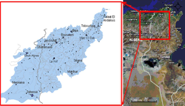
Figure 1
The geographical location of the Medjerda watershed (Nouiri et al., 2015).
2.2. Sampling strategy
13The dense hydrographic network of the Medjerda watershed and the multitude of water harvesting structures make this area vulnerable to several forms of pollution, either through effluents discharge or solid wastes. In order to assess the physicochemical contamination level in the Medjerda watercourse and its tributaries five sampling sites were selected: River Mellègue (S1), Boussalem (S2), River Kasseb (S3), River Béjà (S4) and Medjez El Beb (S5) (Figures 2 and 3). The sampling stations were selected mainly for: (i) their pollution sources along the river and its tributaries, (ii) their accessibility, and (iii) the results obtained in previous works (Etteieb et al., 2017; Mlayah et al., 2017).
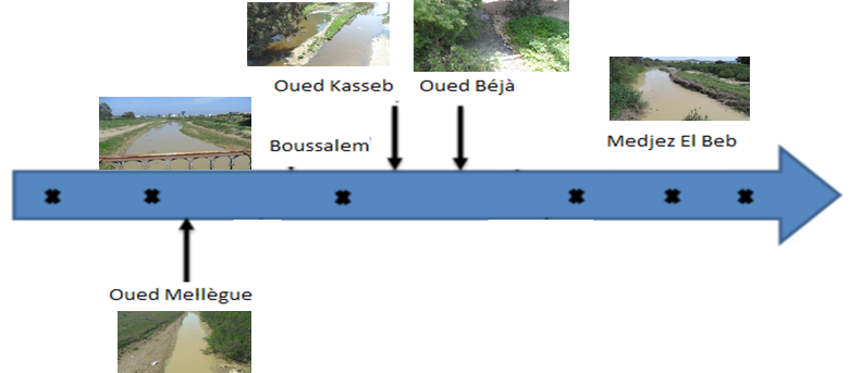
Figure 2
Location of the 5 sampling sites along the Medjerda River
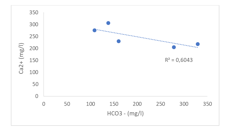
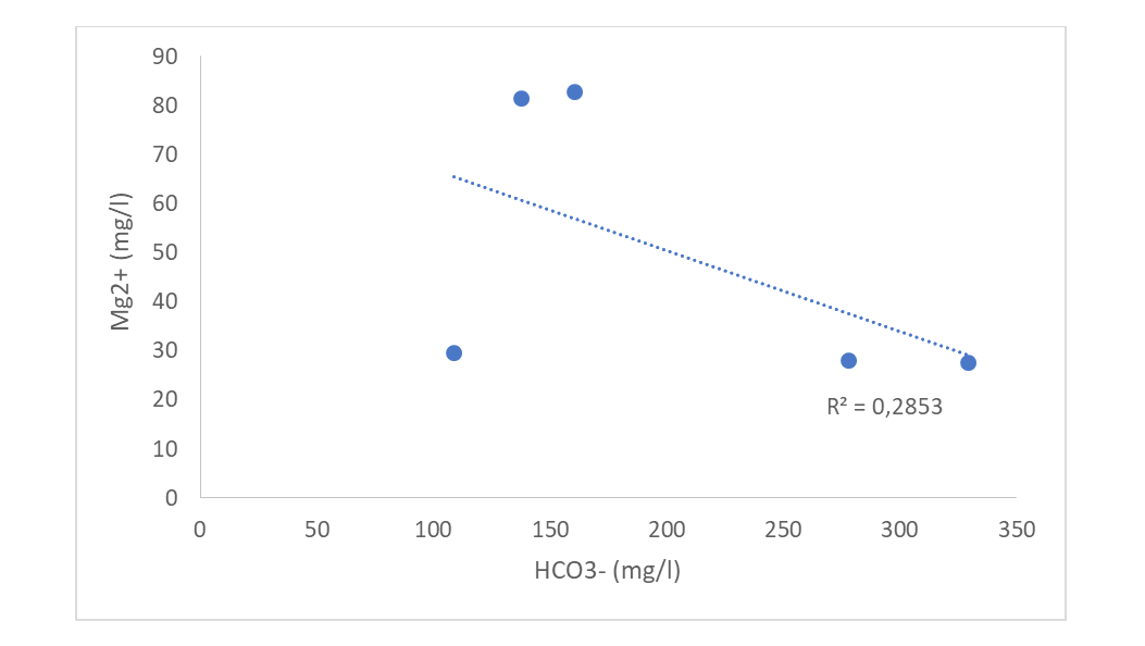
14As previously mentioned, the Medjerda River is influenced by urban and industrial wastewater. Indeed, five treatment plants (TWW) discharge their treated wastewater in it and are represented in Figure 3 by WWTP 1 (Jendouba), WWTP 2 (Boussalem), WWTP 3 (Béjà), WWTP 4 (Medjez El Beb), and WWTP 5 (Jedaida). Four primary industries are also discharging their effluents, namely milk factory (IWW1 in River Kasseb), the municipal slaughterhouse of Béjà (IWW2), sugar and yeast factory (IWW3), and tomato factory (IWW4). Figure 3 also included six closest mines to the investigated sampling sites (1: Fej Hassine; 2: Djebel Diss; 3: Djebba; 4: Djebel Hamera; 5: Djebel Sidi Ahmed, and 6: Djebel Hallouf).
15Two campaigns were conducted to show the sampling period's influence on the water and sediment quality of the Medjerda River. The first one was at the end of the moist/humid period (At the beginning of April 2017), and the second one was at the mid-time of the dry period (The end of May 2017), which is in line with the increase of irrigation and drinking water demand. In the dry season and all sites, the water river turned dark with a severe odour problem. For the second campaign, only samples from the first four sites were collected due to a problem of access.
16Surface water and sediments were sampled, and these latter were analyzed only for the presence of heavy metals.
17One liter of water was collected from the investigated sites in a plastic bottle, 10 to 50 cm below the surface to avoid the direct effect of solar ultraviolet radiation on the water surface layer (Karbasdehi et al., 2017). Approximately 200 g of sediments were also sampled in plastic bags. It represents a composite sample collected from several points, that could reflect the heterogeneity of the area.
18All the samples were labeled and transported to the laboratory in a cooler (4°C) to be analyzed.
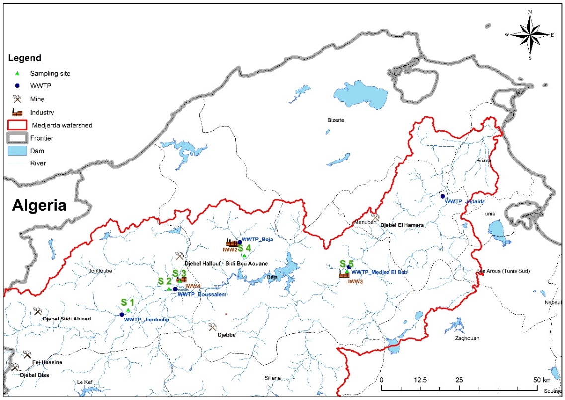
Figure 3
Location of the 5 investigated sites in the Medjerda watercourse along with the location of mines, industrial and urban pollution
2.3. Physicochemical analysis
19The following elements were determined, namely:
-
Carbonates (CO32-) and bicarbonates (HCO3-) ions by the titrimetric method, according to Rodier (2009).
-
Calcium (Ca2+) and magnesium (Mg2+) ions, used for the calculation of the total hardness (TH), were quantified by complexometric titration using the standardized EDTA solution. A major application of EDTA titration is testing the hardness of water of which the method described is an official one (Standard Methods for the Examination of Water and Wastewater, Method 2340C; AOAC Method 920.196).
-
Total suspended solids (TSS) by the method of filtration (0.45 µm).
20For sediments, only nutrients and heavy metals were assessed, and more particularly Iron (Fe), Lead (Pb), Cadmium (Cd), Zinc (Zn), Nickel (Ni) by atomic absorption spectrophotometer (Perkin Elmer 400). These elements were used for the calculation of two heavy metals indicators.
21Elements and parameters such as pH, electrical conductivity, nitrates, chlorides, total dissolved solids, etc., were determined, and their results were the subject of another article (Ben Ayed et al., 2022).
22Two parameters were calculated to assess the suitability of water samples collected for irrigation purposes:
23*Residual Sodium Carbonate (RSC) to predict the additional sodium hazard potentially associated with CaCO3 and MgCO3 precipitation (Richards, 1964), which was determined as follow:

24*The magnesium hazard (MH) was also calculated according to this equation (Szabolcs and Darab, 1964):

2.4. Assessment of the heavy metal pollution in sediments samples
25In sediments, the degree of contamination by heavy metals was assessed through two indicators: (i) Contamination Factor (CF) and (ii) Pollution Load Index (PLI).
2.4.1. Contamination factor (CF)
26CF is a valuable pollution indicator that qualifies the contamination degree of one given metal in sedments over time. It’s the ratio of a selected metal in the sediment to the background values of the same element.

27Where Cm: Mean concentration of the element; Bm: Metal background concentration. It could be determined from literature (average crustal abundance) or a geologically similar area. The standards values used were those of the closest area, the Agency of the Rhône Mediterranean Corsica Basin (ABRMC 1991). According to this referred agency, the values were as follows for the investigated elements: Fe: 2000 mg Kg-1; Zn: 88 mg Kg-1; Ni: 45 mg Kg-1; Pb: 22 mg Kg-1 and Cd: 0.6 mg Kg-1 (Belabed 2010).
28The contamination factor according to its value could be categorized into four classes (Table 1).
Table 1. Descriptive categories of the contamination factor (Uriah and Shehu, 2014)
|
CF value |
Sediment quality |
|
> 6 |
Very high pollution |
|
3 - 6 |
Considerable pollution |
|
1 - 3 |
Moderate pollution |
|
< 1 |
Low pollution |
2.4.2. Pollution Load Index (PLI)
29PLI provides a simple, comparative means to estimate the level of heavy metal pollution. It is determinated as the nth root of the product of the n contamination factor (CF)

30PLI could also be applied to a zone or an area. Therefore:

31When PLI site or area > 1, it means that pollution exists with progressive deterioration of the site or the area quality; otherwise, if PLI = 1 means a baseline level of pollution and when PLI site or area < 1, there is no metal pollution (Tomlinson et al., 1980).
3. Results and Discussion
3.1. Assessment of the physicochemical quality of water samples and Medjerda watercourse irrigation suitability
32For the assessment of the physicochemical quality of the Medjerda watercourse, ten parameters were followed through two campaigns (Carbonates, bicarbonates, Ca2+, Mg2+, Ca2+/Mg2+, total hardness (TH), Residual Sodium Carbonate (RSC), Magnesium Hazard (MH), Contamination Factor, Pollution Load Index). Due to technical issues, only one parameter (Total Suspended Solids) was followed only through the second campaign. These parameters were followed to assess the suitability for irrigation of the sampled water in the five investigated sites. All these data and knowledge will be critical to understanding the management strategies for long-term productivity.
3.1.1. General data on Medjerda watercourse hydrochemistry
33The order of anionic abundance (mg l-1) recorded at the end of the moist and the half of the dry periods was for the sites 1; 2; 4 and 5 as follow: Cl- > HCO3- > CO32- > NO3- and for the site 3 of River Kasseb: HCO3- > Cl- > CO32- > NO3-. For cationic abundance (mg l-1), the calcium was the most abundant element (Ca2+ > Mg2+) in all sites and for the two campaigns.
34Binary diagrams were used to identify better the origin of the salts dissolved in the river water (Figure 4 a and b). In all investigated sites, calcium and magnesium concentration (mg l-1) were negatively correlated to that of HCO3- (respectively r = -0,77 and - 0,53), emphasizing that these cations could be originated from calcite (CaCO3) and dolomite (CaMgCO3) dissolution. Their dissolution could increase the water salinity.
35a.
36b.
Figure 4
Relative ionic concentration in the Medjerda watercourse
3.1.2. Calcium, Magnesium ions, and total hardness evolution
37Calcium and magnesium are essential parameters to be considered as they help assess water hardness. Calcium is one of the most abundant natural elements in the environment and can be found in all-natural waters, mainly from limestone areas (Ogunfowokan et al., 2013). Water magnesium content represents a crucial qualitative indicator of the water quality for irrigation (Ogunfowokan et al., 2013). Minerals such as limestone (CaCO3) and dolomite (CaMgCO3) introduce calcium and magnesium ions respectively into water (Morris and Justin, 2014).
38A decrease was noted in the calcium concentrations between the two investigated periods except for site 4. In fact, for the end of the moist period, the calcium concentrations ranged from 210.72 (Site 4) to 351.72 (Site 1) mg l-1 and from 168.58 (Site 3) to 260.53 (Site 1) mg l-1 in half of the dry one (Figure 5). The highest results were found in River Mellègue for both campaigns, which is an immediate consequence of its geological composition (Mlayah et al., 2017). The decrease in calcium concentrations between the two campaigns in sites 1, 2, and 3 could be related to its adsorption onto clay minerals and deposition to the bottom in the dry season, as observed by El Bourie (2008). The reported concentrations were within the permissible limit (< 1600 mg l-1) for FAO guidelines for water irrigation, as reported in Table 5 (FAO, 1994).
39The magnesium concentrations were lower than those of the calcium. They ranged from 25.51 recorded in River Kasseb to 61.65 mg l-1 observed in River Mellègue for the first campaign and from 27.58 (Site 4) to 133.10 mg l-1 (Site 2) for the second one (Figure 5). A considerable increase in their concentrations was noted in River Mellègue (From 61.65 to 101.38 mg l-1) and Boussalem (32.41 to 133.10 mg l-1) between the two sampling periods. Water release for irrigation for water availability from the Kasseb dam (Site 3) during the second campaign assured a vital reduction in magnesium concentrations in the last two sampling sites (Sites 3 and 4). Magnesium concentrations in site one and site 2 (Only for the second campaign) were higher than the permissible limit (< 10 mg l-1) of water irrigation (FAO, 1994), as represented in Table 5. This excess could lead to scale formation. High levels of dissolved magnesium in irrigation water are coupled with soil infiltration; its soil absorption rate is lower than that of calcium and more significant than sodium (Roy et al., 2015).
40The weight ratio Ca2+/Mg2+ was calculated to estimate the effects of sodium in the soil (Table 2). According to Roy et al. (2015), the sodium effects in soil could be increased when this ratio is lower than 1. For this study, there is only one water sample collected in the second campaign from Boussalem, where the soil sodium effects could be increased. This could be emphasized with the observed higher concentrations of total dissolved solids (> 2000 mg l-1) and high electrical conductivity (6090 µS cm-1) reported in this same site (Data not shown).
Table 2. Weight ration Ca2+/Mg2+in the 5 investigated sites and for the two campaigns
|
Sampling sites |
Sampling periods |
Ca2+ mg/l (meq l-1) |
Mg2+ mg/l (meq l-1) |
Ca2+/Mg2+ |
|
River Mellègue |
1st Campaign |
351,7 (15.79) |
61,6 (5.07) |
3.11 |
|
2nd Campaign |
260,5 (11.69) |
101,4 (8.34) |
1.40 |
|
|
Boussalem |
1st Campaign |
268,2 (12.04) |
32,4 (2.66) |
4.51 |
|
2nd Campaign |
191,6 (8.60) |
133,1 (10.95) |
0.78 |
|
|
River Kasseb |
1st Campaign |
241,4 (10.83) |
25,5 (2.10) |
5.16 |
|
2nd Campaign |
168,6 (7.57) |
30,4 (2.49) |
3.03 |
|
|
River Béjà |
1st Campaign |
210,7 (9.46) |
27,6 (2.27) |
4.16 |
|
2nd Campaign |
226,0 (10.15) |
27,6 (2.27) |
4.47 |
|
|
Medjez El Beb |
1st Campaign |
275,8 (12.38) |
29,6 (2.44) |
5.07 |
41Total hardness (CaCO3) depends upon the concentrations of calcium and magnesium salts and represents an indicator for water suitability to irrigation. According to the classification of Sawyer and McCarthy (1967), the Medjerda watercourse is characterized by very hard water (> 200 mg l-1) with, for the end of the moist period, values recorded of 1043.0 mg l-1 for River Mellègue, 1001.5 mg l-1 for Boussalem; 735.0 mg lL-1 for River Kasseb; 977.5 mg l-1 for River Béjà and 646.5 mg l-1 for Medjez El Beb. For half of the dry campaign, total hardness concentrations ranged from 503.0 to 741.0 mg l-1 (Figure 5). A slight decrease was noted for the first sampling campaign from upstream to downstream except for the last station. The obtained values are correlated to the rocks' geochemical nature of the Medjerda watershed and the phenomenon of evaporation. Irrigation with hard water could affect: (i) the plants' absorption, thus leading farmers to increase their irrigation rate to try to compensate for this deficiency, (ii) the soil by increasing its salinity and (iii) the irrigation equipment through leaving deposits and clogging.
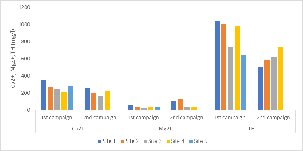
Figure 5
Calcium (Ca2+), Magnesium (Mg2+) ions, total hardness concentrations evolution for the two campaigns and for the five investigated sites
Site 1: River Mellègue; Site 2: Boussalem; Site 3: River Kasseb; Site 4: River Béjà; Site 5: Medjez El Beb; TH: Total hardness
3.1.3. Evolution of the carbonates, bicarbonates ions and total suspended solids.
42Carbonates concentrations ranged between 18.0 (River Mellègue) and 49.8 (Medjez El Beb) mg L-1 and between 18.0 (River Mellègue) and 66.0 (River Kasseb) mg l-1 for respectively the end of the moist period (Beginning of April) and the half part of the dry one (End of May). Between the two campaigns, carbonate ions showed no variation for River Mellègue and a considerable increase in River Kasseb, where concentrations passed from 16.5 to 66.0 mg l-1. Moreover, a significant decrease was reported in River Béjà, where ions concentrations dropped from 37.8 to 13.8 mg l-1 (Table 3).
43Concentrations of bicarbonates are higher than carbonates and showed an increase from upstream to downstream except for the last sampling site (Table 3). The lowest and the highest concentrations were obtained, respectively, for the end of the moist period, in Medjez El Beb (162.3 mg l-1) and River Béjà (306.3 mg l-1). For the second campaign, the lowest value was reported in River Mellègue (113.5 mg l-1) and the highest one in River Kasseb (318.5 mg l-1). A decrease in bicarbonates concentrations from the first to the second campaign was noted for sites 1 and 2 as carbonates are uncommon in the abundant Triassic salt outcrops in these areas, as reported by Mlayah et al. (2017). However, an increase was noted for the two last sites. All the obtained data are within the level decreed by the FAO guidelines for irrigation (90 – 500 mg L-1) (FAO, 1994).
44Due to a technical issue, total suspended solids (TSS) were determined only in the dry period and ranged from 960 (Site 4) to 1538 (Site 2) mg l-1. This parameter conforms to the FAO regulation (FAO, 1994) and doesn’t pose a risk when the water is used for irrigation as the four sampling sites didn’t exceed 2000 mg l-1 (Table 5).
Table 3. Carbonates and bicarbonates ions evolution through the two campaigns and in the 5 investigated sites
|
CO32- (mg l-1) |
HCO3 - (mg l-1) |
|||
|
1st campaign (Moist period) |
2nd campaign (Half of the dry period) |
1st campaign (Moist period) |
2nd campaign (Half of the dry period) |
|
|
River Mellègue |
18.0 |
18.0 |
162.3 |
113.5 |
|
Boussalem |
27.9 |
33.9 |
170.8 |
150,0 |
|
River Kasseb |
16.5 |
66.0 |
238.0 |
318.5 |
|
River Béjà |
37.8 |
13.8 |
306.3 |
352.2 |
|
Medjez El Beb |
49.8 |
- |
108.6 |
- |
45CO32-: Carbonates, HCO3 -: Bicarbonates
3.1.4. Residual sodium carbonate and magnesium hazard evolution
46The calculated Residual Sodium Carbonate (RSC) assesses the hazardous effects of sodium on water used for irrigation, which can be increased if the water contains high concentrations of bicarbonates ions. All water samples presented negative RSC and were lower than 1.25 meq L-1 (Richards, 1954), meaning that the amount of dissolved calcium and magnesium ions in the investigated sites was higher than carbonates and bicarbonates contents (Table 4). Thus, they could be considered reasonable and safe for irrigation purposes in both campaigns regarding this parameter.
47For Magnesium Hazard (MH), all water samples presented values less than 50 (Szabolcs and Darab, 1964) and thus are considered suitable for irrigation. It ranged between 10 and 15 for the end of the moist period and between 11 and 41 for the half of the dry one (Table 4). The water demand for irrigation led to an increase in the magnesium hazard, mainly in Boussalem. Importance has to be accorded for this site. We already reported that the ratio Ca2+/Mg2+ was less than one and higher electrical conductivity values and total dissolved salts (Data not shown).
Table 4. Residual Sodium Hazard (RSC) and Magnesium Hazard in water samples of the five investigated sites
|
Sites |
Sampling period |
RSC (meq l-1) |
Magnesium Hazard |
|
Site 1: River Mellègue |
1st campaign |
-19.36 |
15 |
|
2nd campaign |
-18.88 |
28 |
|
|
Site 2: Boussalem |
1st campaign |
-12.32 |
11 |
|
2nd campaign |
-16.93 |
41 |
|
|
Site 3: River Kasseb |
1st campaign |
-9.69 |
10 |
|
2nd campaign |
-3.50 |
15 |
|
|
Site 4: River Béjà |
1st campaign |
-6.51 |
12 |
|
2nd campaign |
-7.31 |
11 |
|
|
Site 5: Medjez El Beb |
1st campaign |
-12.78 |
10 |
48Table 5 capitalizes all the collected data used to assess the investigated sites for irrigation. The assessment of the investigated physicochemical elements allowed to dress a reference status of the Medjerda watercourse and its tributaries through the interpretation of their trend and their interaction. An increase was noted in the concentrations of Mg2+, CO32-, HCO3- (for two sites) during the half part of the dry period due to the presence of low river flow in line with the irrigation demand when point sources dominate, as observed in Jiji et al. (2007).
Table 5.
Suitability analysis of Medjerda River water for irrigation in the humid and the dry periods.
|
Water element |
Normative value for irrigation (Richards, 1954; Szobolcs and Darab, 1964; Sawyer and McCarthy, 1967; FAO,1994; Roy et al., 2015) |
Site 1 |
Site 2 |
Site 3 |
Site 4 |
Site 5 |
||||
|
1st C |
2nd C |
1st C |
2nd C |
1st C |
2nd C |
1st C |
2nd C |
1st C |
||
|
Ca2+ (mg/l) |
< 1600 |
351.7 |
260.5 |
268.2 |
191.6 |
241.4 |
168.6 |
210.7 |
226.0 |
275.8 |
|
Mg2+ (mg/l) |
< 10 |
61.6 |
101.4 |
32.4 |
133.1 |
25.5 |
30.3 |
27.6 |
27.6 |
29.6 |
|
Ca2+/Mg 2+ |
< 1 |
3.11 |
1.1 |
4.51 |
0.78 |
5.16 |
3.03 |
4.16 |
4.47 |
5.07 |
|
TH: CaCO3 (mg L-1) |
< 75 (Soft) |
- |
- |
- |
- |
- |
- |
- |
- |
- |
|
75 – 150 (Moderately high) |
- |
- |
- |
- |
- |
- |
- |
- |
- |
|
|
150 – 300 (High) |
- |
- |
- |
- |
- |
- |
- |
- |
- |
|
|
> 200 (Very high) |
1043.0 |
1001.5 |
735.0 |
977.5 |
646.5 |
503.0 |
586.5 |
621.0 |
741.0 |
|
|
CO32- (meq L-1) |
0 - 1 |
0.59 |
0.59 |
0.92 |
1.11 |
0.54 |
2.17 |
1.24 |
0.45 |
1.64 |
|
HCO3-(mg L-1) |
90- 500 |
162.3 |
113.5 |
170.8 |
150;0 |
238.0 |
318.5 |
306.3 |
352.2 |
108.6 |
|
TSS (mg L-1) |
< 2000 |
1362 |
1538 |
1054 |
960 |
|||||
|
RSC (meq L-1) |
< 1.25 (Good) |
-19.36 |
-18.88 |
-12.32 |
-16.93 |
-9.69 |
-3.50 |
-6.51 |
-7.31 |
-12.78 |
|
1.25 – 2.50 (Doubtful) |
- |
- |
- |
- |
- |
- |
- |
- |
- |
|
|
> 2.50 (Unsuitable) |
- |
- |
- |
- |
- |
- |
- |
- |
- |
|
|
MH |
< 50 |
15 |
28 |
11 |
41 |
10 |
15 |
12 |
11 |
10 |
491st C: First campaign; 2nd C: Second campaign; Site 1: River Mellègue; Site 2: Boussalem; Site 3: River Kasseb; Site 4: River Béjà; Site 5: Medjez El Beb; TH: Total Hardness, RSC: Residual Sodium Carbonate, MH : Magnesium Hazard
50Data put in bold are in excess comparing to water irrigation guidelines.
3.2. Evaluation of the nutrient and heavy metal contamination in sediments
Sediments act as reservoirs of trace metals (Sharma and Subramanian, 2010); play an essential role in the transport of pollutants and the interactions between the two phases (Water-sediment). Consequently, this will affect the river water quality and lead to a fearful danger of the environment, namely death or intoxication of the aquatic population or plants-accumulation by irrigation after sediment resuspension (Martin and Meybeck, 1979). Moreover, fine particles of the sediments possess a large surface area used for heavy metals adsorption (Jain et al., 2008).
To assess the extent of anthropogenic pollution in sediments, two indicators were determined: (i) Contamination Factor and (ii) Pollution Load Indicator.
3.2.1. Contamination factor and Pollution load index
51To further examine the heavy metal pollution in sediments, the contamination factor (CF) and the pollution load index (PLI) were assessed (Table 6). Among all investigated nutrient and heavy metals, iron had the lowest CF among all four sampling sites. In contrast, the contamination factor of Cd was the highest one in all explored areas except for site 3 in the moist period, where CF- Pb was the highest one. In Ali et al. (2016)’s work in Karnaphuli River in Bangladesh, Cd also showed a very high degree of contamination (CF > 6) as reported in this study for sites 3, 4, and 5. The contamination factors obtained denoted low to considerable pollution for Zn, low to moderate pollution for Ni, considerable to very high pollution for Cd, and low to very high pollution for Pb. The variation of the metal concentrations depends on the distance from the pollution source, the nature, and the behaviour of the elements released from mine wastes and tailings (Mlayah et al., 2005). The highest CF obtained was for lead in sediments collected from River Kasseb at the end of the moist period (41,82). Considerable attention has to be accorded to the sediments pollution as this indicator argued on the presence of toxicity that could be generated by cadmium and lead.
52In sediments, heavy metals usually occur as a complex mixture with important variations; the pollution load index (PLI) was thus applied. It is a useful tool for assessing a site or a zone quality and indicating the trend over time and area (Mohiuddin et al., 2010). For this study, PLI values of the Medjerda river sediments ranged from 1.66 to 5.27 at the end of the moist period and from 0.49 to 1.45 for the second campaign, arguing on the sediment’s contamination of the investigated sites (PLI > 1). The highest values were respectively obtained in River Kasseb and River Mellègue. The Mellègue watershed contains the abandoned mines of the Sakiet Sidi Youssef, Garn Halfaya, Boujabeur, Zag et Tir, Nebeur, and Touireuf (Pb–Zn) (Mlayah et al., 2009). Data obtained emphasize that importance has to be accorded to these sites mainly in the moist period. For the first campaign, PLI followed this order: Site 3 > Site 4 > Site 1 > Site 2 while for the second one, it followed this one: Site 4 > Site 1 > Site 3 >Site 2. The PLI values decreased from one campaign to the other. For the second campaign, the pollution wasn’t reported in the three first sites exception made for the last one. The pollution load index in the investigated sites was remarkably higher in the moist period than the dry one, as also observed in Mohiuddin et al. (2011).
53PLI is also a valuable tool to deliver information to the decision-makers on the pollution status of an area (Suresh et al., 2012). PLI of the whole area at the end of the moist period was equal to 2.308, indicating that the investigated elements were the significant pollutants. In contrast, it was equivalent to zero in the half of the dry period. It could be correlated to the resuspension of the pollution in line with irrigation demand.
Table 6. Variation of the contamination factors and the pollution load index in the sediments of the 4 investigated sites along the Medjerda watercourse.
|
Fe |
Zn |
Ni |
Pb |
Cd |
PLI |
||
|
Site 1 |
1st campaign |
0.73 |
1.20 |
1.08 |
2.42 |
5.5 |
1.66 |
|
Category description |
Low pollution |
Moderate pollution |
Moderate pollution |
Moderate pollution |
Considerable pollution |
Pollution presence |
|
|
2nd campaign |
0.33 |
0.57 |
0.45 |
1.78 |
4.41 |
0.92 |
|
|
Category description |
Low pollution |
Low pollution |
Low pollution |
Moderate pollution |
Considerable pollution |
Pollution absence |
|
|
Site 2 |
1st campaign |
0.71 |
0.98 |
1.0 |
1.83 |
5.0 |
1.45 |
|
Category description |
Low pollution |
Low pollution |
Moderate pollution |
Moderate pollution |
Considerable pollution |
Pollution presence |
|
|
2nd campaign |
0.007 |
0.0 |
0.27 |
0.38 |
3.33 |
0.0 |
|
|
Category description |
Low pollution |
No contamination |
Low pollution |
Low pollution |
Considerable pollution |
Pollution absence |
|
|
Site 3 |
1st campaign |
0.70 |
4.87 |
1.25 |
41.82 |
22.66 |
5.27 |
|
Category description |
Low pollution |
Considerable pollution |
Moderate pollution |
Very high pollution |
Very high pollution |
Pollution presence |
|
|
2nd campaign |
0.004 |
2.34 |
0.33 |
0.74 |
12.75 |
0.49 |
|
|
Category description |
Low pollution |
Low pollution |
Low pollution |
Low pollution |
Very high pollution |
Pollution absence |
|
|
Site 4 |
1st campaign |
0.69 |
1.53 |
1.25 |
4.98 |
8.50 |
2.24 |
|
Category description |
Low pollution |
Moderate pollution |
Moderate pollution |
Considerable pollution |
Very high pollution |
Pollution presence |
|
|
2nd campaign |
0,20 |
1.27 |
0.73 |
2.44 |
6.33 |
1.24 |
|
|
Category description |
Low pollution |
Moderate pollution |
Low pollution |
Moderate pollution |
Very high pollution |
Pollution presence |
54Due to a problem of access, sediments were sampled only for the first 4 sites.
55All these data are helpful to evaluate the anthropogenic impacts in the Medjerda River and assess the risks posed by pollution discharges. Considering pollution indicators, this study’s findings confirm that the heavy metal pollution of the Medjerda watercourse sediments is severe. Their variability depicted differences in the magnitude of anthropogenic inputs for each metal and different removal rates from the sediment.
Conclusion
56The Medjerda River, the primary source of freshwater for several governorates and cities in Tunisia, is exposed to deterioration of its water quality.
57Pollutants in surface water might lead to ecosystem disturbance and public health problems. Therefore, it is crucial to frequently assess the Medjerda watercourse quality and its suitability for both drinking and agricultural water uses. The research team has planned a frequent assessment of this river through the two periods.
58In Mellègue River, higher Ca2+, Mg2+, and total hardness concentrations were found. In Boussalem, Ca2+/Mg2+ was less than one, and MH denoted the highest value obtained.
59An excess to normative values set by FAO (1994) was reported for concentrations of Mg2+, total hardness, and CO32-. This could lead to disorders in soil and plants.
60Two indicators of the heavy metal’s impacts were assessed in sediments samples to grape the pollution characteristics of the local environment. Critical contamination of heavy metals was noted in sediments arguing on anthropogenic pollutions mainly when it deals with toxic elements such as cadmium, as indicated in Kasseb and Mellègue Rivers.
Further information
Authors contribution
Conceptualization
LBA; Data curation: LBA; Formal analysis: LBA, SS, IN, PK; Investigation: LBA, MH; Methodology: LBA, Writing original draft: LBA; Writing – Review and editing: LBA, SS, IN, PK; Validation: LBA, IN, SS, PK; Resources: LBA; Visualization: LBA, SS; Supervision: IN, PK; Project administration: LBA, IN, PK.
Conflicts of interest
61The authors declare no conflict of interest.
References
62Abidi, S., Béjaoui, M. and Boumaiza, M. (2011) Influence de la pollution sur la qualité des eaux et la méiofaune de l’oued Kasseb (Tunisie septentrionale). Bulletin de la Société Zoologique de France, 136, 145-157.
Abidi, S., Bejaoui, M., Jemli, M. and Boumaiza, M. (2015) Qualité des eaux du cours principal de la Medjerda (Tunisie et Algérie) et trois de ses affluents Nord. Hydrological Sciences Journal, 60, 1607-1619. https://doi.org/10.1080/02626667.2014.909597
63ABRMC. (1991) Pollution du Rhône. Synthèse des connaissances. Ministère de l’environnement Français 7 (71470), 26 p.
64Aderibigbe, S.A., Awoyemi, A.O. and Osagbemi, G.K. (2008) Availability, adequacy and quality of water supply in Ilorin Metropolis, Nigeria. European Journal of Scientific Research, 23(4), 528-536.
65Ali, M.M., Ali, M.L., Islam, M.S., and Rahman, M.Z. (2016). Preliminary assessment of heavy metals in water and sediment of Karnaphuli River, Bangladesh. Environmental Nanotechnology, Monitoring & Management, 5, 27-35.
66Bauder, T.A., Waskom, R.M., Sutherland, P.L. and Davis, J.G. (2011) Irrigation water quality criteria. Fact Sheet No. 0.506. Crop series Irrigation. Colorado State University.
67Belabed, B. (2010) La pollution par les métaux lourds dans la région d’Annaba « Sources de contamination des écosystèmes aquatiques ». Thèse de Doctorat en Sciences. Université Badji Mokhtar Annaba. 199 p.
68Ben Ayed, L., Horry, M., Sabbahi, S., Nouiri, I. and Karanis P. (2022). Water and sediments quality assessment of Medjerda River in Tunisia. Arabian Journal of Geosciences 15 : 463. https://doi.org/10.1007/s12517-022-09667-2
69Ben Hamza, C. (1994) Bilan hydrologique, sédimentologique et géochimique d'un bassin versant en zone semi-aride : la Medjerda (Tunisie du nord) : impacts sur l'environnement. Doctoral dissertation, Paris 6.
70Benjamin, R., Chakrapani, B.K., Devashish, K., Nagarathna, A.V., Ramachandra, T.V. (1996) Fish mortality in Bangalore Lakes, India. EGJ 1(6). http://escholarship.org/uc/item/00d1m13
71Bonanno, G. and Lo Giudice, R. (2010) Heavy metal bioaccumulation by the organs of Phragmites australis (common reed) and their potential use as contamination indicators. Ecological Indicators, 10, 639-645. https://doi.org/10.1016/j.ecolind.2009.11.002.
72Chaabane, S., Riahi, K., Hamrouni, H. and Ben Thayer, B. (2016) Suitability assessment of the water quality of Medjerda wadi (Kalaat Landalous) for irrigation purpose. Journées Scientifiques de la Medjerda 2016 « Pour le bien-être de tous: un environnement protégé pour des terres mieux abreuvées », 24-29.
73Dinka, M.O. (2010) Analyzing the extents of Basaka Lake Expansion and Soil and Water Quality Status of Matahara Irrigation Scheme, Awash Basin (Ethiopia). PhD Dissertation, University of Natural Science and Applied Life Sciences, Vienna. Bibliographic information available from INIS: http://inis.iaea.org/search/search.aspx?orig_q=RN:43074757.
74Dungan, J.L., Perry, J.N., Dale, M.R.T., Legendre, P., Citron-Pousty, S., Fortin, M.J., Jakomulska, A., Miriti, M. and Rosenberg, M.S. (2002) A balanced view of scale in spatial statistical analysis. Ecography, 25, 626–640. https://doi.org/10.1034/j.1600-0587.2002.250510.x
75El-Bourie, M.M.Y. (2008) Evaluation of organic pollutants in Rosetta branch water-River Nile (M. SC. Thesis). Faculty of Sciences, Tanta University, Egypt.
76Etteieb, S., Cherif, S. and Tarhouni, J. (2017) Hydrochemical assessment of water quality for irrigation: a case study of the Medjerda River in Tunisia. Applied Water Science, 7, 469-480. https://doi.org/10.1007/s13201-015-0265-3
77Food and Agriculture Organization (FAO). (1994) Water quality for agriculture, 29 Rev. 1, p 174. ISBN 92-5-102263-1.
78Islam, M., Ahmed, M., Habibullah-Al-Mamun, M., and Hoque, M. (2015). Preliminary assessment of heavy metal contamination in surface sediments from a river in Bangladesh. Environmental Earth Sciences, 73(4), 1837-1848.
79Jain, C.K., Gupta, H. and Chakrapani, G. J. (2008) Enrichment and fractionation of heavy metals in bed sediments of River Narmada, India. Environmental Monitoring and Assessment, 141(1), 35-47.
80Jdid, E., Blazy, P. and Kamoun, S. (1998) Caractérisation de la pollution par les métaux lourds des eaux du nord-ouest tunisien. Sciences de la terre. Informatique géologique, 50-58.
81Kachroud, M., Trolard, F., Jebari, S., Kefi, M. and Bourrié, G. (2016) Évaluation géochimique des eaux du cours principal de la Medjerda. Conference paper in Journées scientifiques de la Medjerda 2016 «Pour le bien-être de tous : un environnement protégé pour des terres mieux abreuvées», 36-41.
82Karbasdehi, V.N., Dobaradaran, S., Nabipour, I., Ostovar, A., Arfaeinia, H., Vazinizadeh, A., Mirahmadi, R., Keshtkar, M., Ghasemi, F.F. and Khalifei, F. (2017) Indicator bacteria community in seawater and coastal sediment: the Persian Gulf as a case. Journal of Environmental Health Science and Engineering 15(1), 1-15. https://doi.org/10.1186/s40201-017-0266-2
83Martin, J.M. and Meybeck, M. (1979) Elemental mass-balance of material carried by major world rivers. Marine Chemistry, 7(3), 173-206.
84Mlayah, A, Yoshida, M, Charef, A, Ferreira da Silva, E, Noronha, F, Patinha, C (2005) Impact des rejets miniers et domestiques sur la qualité des sédiments et des eaux de l’oued Mellègue (NW de la Tunisie) : diagnostic des métaux lourds. In: Proc, VIII Congresso de Geoquimica Actas, vol 2, pp 621–6
85Mlayah, A., Ferreira da Silva, E., Rocha, F., Ben Hamza, C., Charef, A., Noronha, F. (2009) The oued Mellègue: Mining activity, stream sediments and dispersion of base metals in natural environments, North-western Tunisia. Journal of Geochemical Exploration, 102, 27-36. https://doi.org/10.1016/j.gexplo.2008.11.016
86Mlayah, A., Lachaal, F., Chekirbane, A., Khadar, S. and Da Silva, E. F. (2017) The fate of base metals in the environment and water quality in the Mellegue Watershed, Northwest Tunisia. Mine Water and the Environment, 36, 163-179. Doi: 10.1007/s10230-017-0430-z
87Mohiuddin, K.M., Zakir, H.M., Otomo, K., Sharmin, S. and Shikazono, N. (2010) Geochemical distribution of trace metal pollutants in water and sediments of downstream of an urban river. International Journal of Environmental Science and Technology, 7(1), 17-28.
Necibi, M. and Mzoughi, N. (2020) Determination of organochlorine pesticides in the surface water from Medjerda river, Tunisia. International Journal of Environmental Analytical Chemistry, 1-12. https://doi.org/10.1080/03067319.2020.1849668
88Nouiri, I., Jeridi, A., Ben Abdelmalek, M., Chalgoumi, N. and Ben Ali, H. (2015) Modélisation de la gestion des ressources en eau de surface du bassin Transfrontalier Tuniso-Algérien de la Medjerda sous l’environnement de calcul WEAP. Conference paper in Eau Climat’2015 - Constantine, 24 et 25 Novembre 2015.
89Ogunfowokan, A. O., Obisanya, J. F. and Ogunkoya, O. O. (2013) Salinity and sodium hazards of three streams of different agricultural land use systems in Ile-Ife, Nigeria. Applied Water Science, 3(1), 19-28. Doi: 10.1007/s13201-012-0053-2.
90Ravikumar, P., Mehmood, M.A. and Somashekar R.K. (2013) Water quality index to determine the surface water quality of Sankey tank and Mallathahalli lake, Bangalore urban district. Karnataka, India. Applied Water Science, 3, 247-261. Doi: 10.1007/s13201-013-0077-2.
91Richards, L.A. (1954) Diagnosis and improvement of saline alkali soils: Agriculture, vol 160. Handbook 60, US Department of Agriculture, Washington DC
92Rodier, J., Legube, B. and Merlet, N. (2009) L’analyse de l’eau. 9è édition. Dunod: Paris. 1579 p.
Roy, K., Ansari, M.S., Karim, M.R., Das, R., Mallick, B. and Gain, A. K. (2015) Irrigation water quality assessment and identification of river pollution sources in Bangladesh: implications in policy and management. Journal of Water Resource and Hydraulic Engineering, 4, 303-317. Doi: 10.5963/JWRHE0404001.
93Saleem, M., Iqbal, J., and Shah, M.H. (2015). Geochemical speciation, anthropogenic contamination, risk assessment and source identification of selected metals in freshwater sediments—a case study from Mangla Lake, Pakistan. Environmental Nanotechnology, Monitoring and Management, 4, 27-36.
94Sawyer, C., & McCarthy, P. (1967) Chemical and sanitary engineering.
95Sharma, S.K. and Subramanian, V. (2010) Source and distribution of trace metals and nutrients in Narmada and Tapti River basins, India. Environmental Earth Sciences, 61, 1337-1352
96Singh, G. and Kamal, R.K. (2014) Application of water quality index for assessment of surface water quality status in Goa. Current World Environment, 9(3), 994. http://dx.doi.org/10.12944/CWE.9.3.54
97Slimani, N., Guilbert, E., Ayni, F.E., Jrad, A., Boumaiza, M. and Thioulouse, J. (2017) The use of STATICO and COSTATIS, two exploratory three-ways analysis methods: an application to the ecology of aquatic heteroptera in the Medjerda watershed (Tunisia). Environmental and Ecological Statistics, 24(2), 269-295.
98Slimani, N., Jiménez, J.J., Guilbert, E., Boumaïza, M. and Thioulouse, J. (2020) Surface water quality assessment in a semiarid Mediterranean region (Medjerda, Northern Tunisia) using partial triadic analysis. Environmental Science and Pollution Research, 27(24), 30190-30198.
99Suresh, G., Sutharsan, P., Ramasamy, V., & Venkatachalapathy, R. (2012). Assessment of spatial distribution and potential ecological risk of the heavy metals in relation to granulometric contents of Veeranam lake sediments, India. Ecotoxicology and environmental safety, 84, 117-124.
100Szabolcs, I. and Darab, K. (1964) Radio-Active technique for examining the improving effect of CaCO3 on alkali (Szik) soils. Acta. Agron. Hungary, 13(1), 93-101.
101Tomlinson, D.L., Wilson, J.G., Harris, C.R. and Jeffrey, D.W. (1980) Problems in the assessment of heavy-metal levels in estuaries and the formation of a pollution index. Helgoländer Meeresuntersuchungen, 33(1), 566-575.
102Uriah, L. A. and Shehu, U. (2014) Environmental risk assessment of heavy metals content of municipal solid waste used as organic fertilizer in vegetable gardens on the Jos Plateau, Nigeria. American Journal of Environmental Protection, 3(6-2), 1-13. doi: 10.11648/j.ajep.s.2014030602.11
