


- Accueil
- Volume 19 (2016)
- number 3-4
- Filling the North Sea Basin: Cenozoic sediment sources and river styles (André Dumont medallist lecture 2014)


Visualisation(s): 10894 (80 ULiège)
Téléchargement(s): 6390 (34 ULiège)

Filling the North Sea Basin: Cenozoic sediment sources and river styles (André Dumont medallist lecture 2014)

Abstract
The history of the infilling of the North Sea is outlined, with particular focus on sediment sources and river inputs. In simple terms (for the detail is complex), these sources changed from domination by northwesterly sources from the Shetland area (Paleocene to Eocene), to a geographically more uniform basin-centred pattern, and then northerly input following Fennoscandian uplift (Oligocene and Neogene). Baltic inputs followed via an ‘Eridanos (Baltic) River’ (Miocene), with cold-climate coarser sediment inputs, and lacustrine episodes resulting from ice damming (Pleistocene). River styles in each of these phases are discussed, with the Cenozoic at first being dominated by low energy fluvial deposition (channel sands, chemically weathered clays, and organic sedimentation) in fluctuating climates. Cold climates in the latest Neogene and Quaternary are seen as major determinant of a change in fluvial style, though these are also associated with tectonic effects, as in Scandinavia. The mediating role of vegetation, relating also to temperature and precipitation, is also likely to have been significant. Narrow valley incision followed the Middle Pleistocene Transition, as well as an increasing importance of Rhine-Meuse sources that had begun earlier.
Table des matières
1. Introduction
1The recognition that the present landscape is a product of the long-term interaction of tectonics and climate is one of the fundamental concepts in historical geoscience. Determining the response of the environment to these changes has been further emphasised by attempts to understand the relationship between rates of tectonic activity and sedimentation or erosion and the interplay of these factors with climate change (e.g. Cloetingh et al., 2005). Moreover, the dynamic linkage of erosion and tectonics results in major impacts on changes of the Earth’s climate through the evolution of major continental topography and vice versa.
2The form of the Earth’s topography actually results from the net interaction of processes operating at a wide range of time scales. These include long- and short-term tectonic uplift, subsidence, phases of glaciation, and climatic and environmental changes. In northern Europe, these processes, operating simultaneously through the Cenozoic, have left a record of changing conditions that have determined the form of the present landscape. The emphasis recently has been on relatively short-term interactions involving quasi-simultaneous uplift followed shortly by incision, paced alongside Late Pleistocene marine isotope stages, and interacting with climatic fluctuations. Here we take a longer view, that of Cenozoic uplift centres changing in intensity and location, and thus sediment feeds and alluvial styles, feeding into a depositional basin over an extended timescale. The operation of such processes is recorded in the sedimentary record filling the North Sea basin.
3The North Sea is a shallow epicontinental sea between the islands of Great Britain and the European mainland including Scandinavia, Germany, the Netherlands, Belgium, and France. This epeiric (or 'shelf') sea on the European continental shelf connects to the Atlantic Ocean via the English Channel in the south and the Norwegian Sea in the north. It is over 970 km long by 580 km wide at its maximum extent, and has an area of ca. 750,000 km2 (Fig. 1).
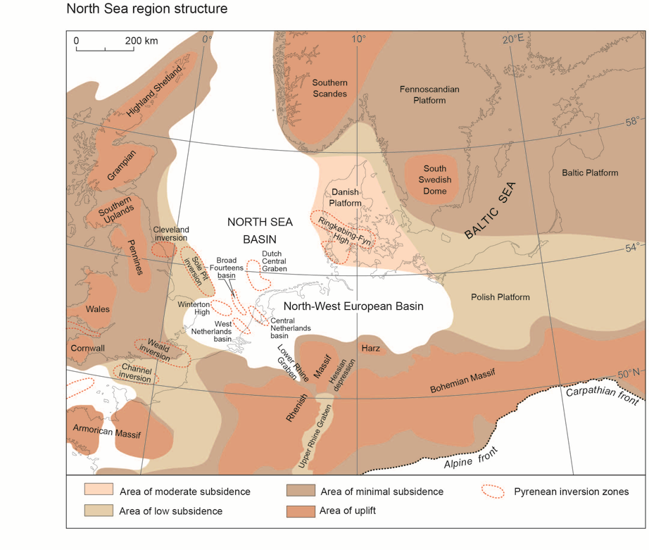
4Figure 1. Tertiary structural elements in the North Sea region, modified from Knox et al. (2010).
5The North Sea has existed since the late Cretaceous periods when rifting resulted in uplift of the British Isles. Since then, this shallow sea has almost continuously existed between the Fennoscandian Shield in the north and the British Isles in the west. Since its first formation, the basin has expanded and contracted with the changing eustatic sea level. During some periods it has connected to neighbouring shallow epicontinental basins, including the Paris Basin to the south-west, the Paratethys Sea to the south-east, or the Tethys Ocean to the south.
6Until the late Quaternary, the Cenozoic strata of the northern European area were deposited within a single substantial depositional complex referred to as the Tertiary North-west European Basin (Vinken, 1988) (Fig. 1). Widespread uplift and associated basinal subsidence in the Neogene (Chalmers & Cloetingh, 2000; Japsen & Chalmers, 2000; Cloetingh et al., 2005, 2009) led to the present-day configuration in which the North Sea Basin is separated from a shallow basin to the south-east, known as the East German – Polish Basin. Fragmentation of the North-west European Basin in the Quaternary led to the formation of the Baltic Sea, but this depression, by contrast, originates from a combination of fluvial and later glacial erosion initiated in the Oligocene (cf. below).
7The Cenozoic fill of the North Sea basin has been the subject of especially intense investigation during the last 40 years as a consequence of the discovery of major oil and gas reserves in the Paleocene and Eocene rocks of the central and northern North Sea. The North Sea basin depocentre, north of the Dogger Bank, is estimated to contain as much as 3500 m of Cenozoic-age sediment, with a maximum of over 1000 m deposited during the Quaternary alone, although it is considerably thinner elsewhere. This implies a tenfold increase in sedimentation during the latter (Caston, 1977). Infill of the basin represents a complex, yet quasi-complete record of events through the period (Knox et al., 2010; Anell et al., 2012) providing a vital record of the interplay of tectonics and climate of the partially land-locked basin through the period (cf. Cloetingh et al., 2005).
8In contrast to the North Sea, the Baltic Sea occupies an enclosed epicontinental depression between the Scandinavian Peninsula, Finland, the Baltic countries, and the North European Plain (Fig. 1). It stretches from 53°N to 66°N latitude and from 10°E to 30°E longitude. The sea is linked to the Atlantic Ocean and the North Sea, between the Danish islands and the Kattegat via the straits of Øresund, the Great Belt and the Little Belt. Geologically the Baltic Sea resembles a river valley complex, with two tributaries, the Gulf of Finland and Gulf of Bothnia. Geological surveys show that before the formation of the Baltic Sea, a wide plain was occupied by a substantial river termed the Eridanos or Baltic River system (cf. below). In contrast to the North Sea, the Baltic basin today contains a maximum of ca. 100 m of sediment, although in the south-west the basin may contain greater thicknesses of glacial deposits (Floden, 1980; Amantov et al., 2011). Over most of the basin, the deposits are predominantly of Late Pleistocene age (Amantov et al., 2011), earlier materials having been removed by glacial scour.
2. Palaeogeographical evolution
9The evolution of the North Sea basin region throughout the Cenozoic occurred against a tectonic regime resulting from the fragmentation of the Eurasian-North American plate, and Alpine orogenesis (Knox et al., 2010; Cloetingh et al., 2005). The break-up of the northern hemisphere plate, along the North Atlantic mid-ocean ridge spreading centre, gave rise to tensional or extensional features, whereas Alpine mountain building, arising from continental collision between the Eurasian and African plates, produces compressional features. Although the North Atlantic margins had been regarded as 'passive' (cf. Ziegler, 1978; 1987; 1994; Dewey, 2000; Knox et al., 2010; Anell et al., 2009), active tectonics led to widespread reactivation of older structures, particularly those of Variscan origin, with the Norwegian Atlantic coastal area undergoing substantial vertical movements during the Cenozoic (Cloetingh et al., 1990) (Fig. 1). The interplay between these two processes resulted in structural and depositional palaeogeographical changes through the period (Cloetingh et al., 2005).
2.1. Paleocene
10Following the end of the Cretaceous, the North Sea region saw carbonate sedimentation continue into the Early Paleocene Danian Stage. However, regional uplift occurred arising from underplating of the continent associated with the rise of the Iceland mantle plume combined with north-westward-directed compressional stresses (e.g. Brodie & White, 1994; Ziegler & Dèzes, 2007; Hillis et al., 2008). This late Early Paleocene uplift (the ‘Laramide’ Phase) was followed by a second period of regional uplift in the latest Paleocene, shortly before the continental suture formed between Greenland and Scotland. Significant uplift of Scandinavia also occurred periodically throughout the Paleogene (Clausen et al., 2000) giving rise to drainage directed to the south and southwest. Likewise, uplift events of the East Shetland Platform and the Scottish Highlands, led to the development of drainage aligned towards the east (Hall & Bishop, 2002). This resulted in discharge of substantial sand-rich sediment into the Northern North Sea basin and over 1000 m-thick sedimentation in the Outer Moray Firth Basin during the Late Paleocene and earliest Eocene interval (e.g. White & Lowell, 1997; Anell et al., 2012).
11According to Hall et al. (2015), stable isotope ratios in kaolin from weathered clasts in quartzite- and flint-bearing fluvial gravels and from clay-rich saprolites, developed in igneous rocks, indicate weathering in north-east Scotland took place under Paleogene humid tropical climates. A substantial landmass area was actively dissected by both mechanical and chemical, subaerial denudational processes, with recycling of a thick weathering mantle material arising from long exposure (Gibbard & Lewin, 2003). Correlation with offshore sediments indicates that the Buchan Gravels were deposited by the rivers that supplied the western North Sea Paleocene–Early Eocene deep-water sand fans.
12The extent to which the platform areas to the north-east and east of the North Sea Basin were buried by sediments during the Mid-Paleocene to Eocene is debated (Knox et al., 2010). Regional reconstructions have shown the Baltic Platform remained unburied (e.g. Vinken, 1988; Ziegler, 1990; Ziegler & Horvath, 1996); the platform probably formed low-lying land area, particularly during the Mid- to late Paleocene (Knox et al., 2010). Little is known of the palaeogeographical evolution of the eastern Baltic region during the Paleocene.
13By the Late Paleocene Thanetian Stage, the sea had extended over much of eastern England, with the coastline aligned north–south down the eastern side of the modern Pennines (Knox, 1996; King, 2006) (Fig. 2). The Thanetian sediments of the southern margin are mostly of shallow-marine slightly glauconitic sands, restricted to the eastern part of the London Basin but with equivalents in Belgium and the Paris Basin. Throughout much of southern North Sea region land areas were of low relief, with south-eastwards-aligned drainage in SE England (Murray, 1992), guided by general subsidence of the area. The continental deposits to the east indicate that continued relative uplift of the North Polish Platform was occurring at the time.
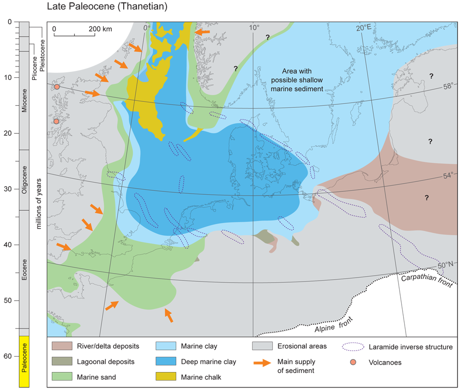
14Figure 2. Late Paleocene (Thanetian) palaeogeography, modified from Gibbard & Lewin (2003) and Knox et al. (2010).
15During this time the rivers apparently adopted flow channels dominated by sands with fine-grained abandoned channel fills. Mottled clays, pedologically modified and associated lignitic units, and sedimentation typically found in vertically-accreted floodplain sequences, are associated with fining-upward channel fills and point-bar accumulations in the Thames Basin. The clay-clast breccias typify meandering river sediments in tropical regions (Miall, 1996). Where the rivers have cohesive banks and densely-vegetated floodplains, they predominantly transport fines, but also coherent blocks of bank material eroded during floods (Gibbard & Lewin, 2003).
2.2. Eocene
16The opening of the North Atlantic Ocean basin was accompanied by renewed thermal subsidence of the North-west European Basin. This initiated more widely distributed, thick Eocene successions, the principal depocentres being the Viking Graben, the central North Sea and northern Germany. Eastwards progradation from the western margin of the basin also occurred in the southern North Sea. Widespread deposition in this region of London Clay occurred during the Ypresian, supplied to the basinal areas by the rivers from the north and west (Fig. 3). The products of the continued earlier weathering replaced the major erosion phases seen earlier. This clay-dominated deposition was terminated by a rapid expansion of fluvial delta complexes towards the east in the late Ypresian-Lutetian (early Middle Eocene), the sediments consisting of cross-bedded sands, with thin clay or silt partings and thin pebble beds, becoming considerably coarser towards the west (Knox et al., 2010).
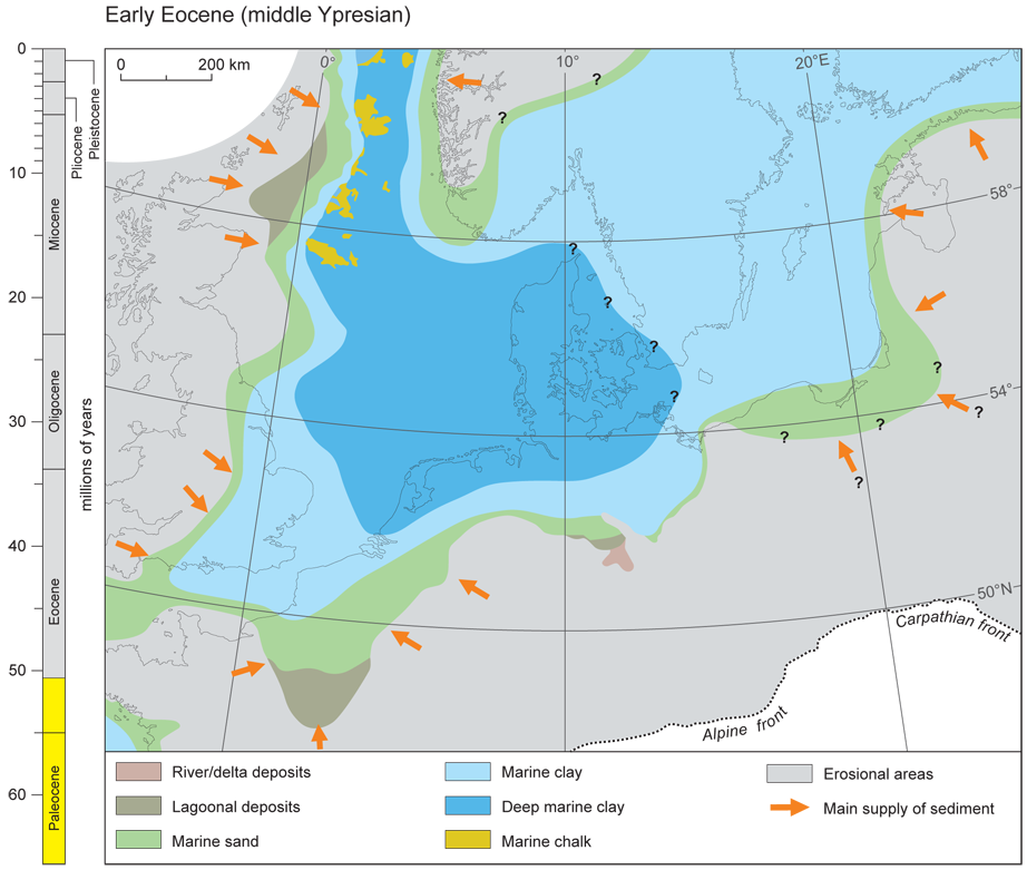
17Figure 3. Early Eocene (middle Ypresian) palaeogeography, modified from Gibbard & Lewin (2003) and from Knox et al. (2010).
18The early Eocene climate of the region was very warm, the land to the north, west and south supporting dense tropical to sub-tropical and warm-temperate forests, with mangrove swamps on the coasts (e.g. Reid & Chandler, 1933; Anderton, 2000; Collinson & Cleal, 2001b). In higher regions to the west, north and east an ‘upland flora’ may have flourished, but temperate elements were also well represented (e.g. Daley, 1972). According to Daley (1972) the flora shows strong general affinities with today's Malay Pensinsula, characterised by high levels of precipitation and environmental stability. The nature of the land surface during the early Eocene appears to have continued to be subdued (e.g. Wells & Kirkaldy, 1966; Daley, 1972). The region was characterised by slow subareal degradation under conditions of intense chemical weathering. The vast volumes of clay owe their origin to extended weathering in the catchments of rivers flowing from the more distant, higher-ground areas (Gibbard & Lewin, 2003).
19During the later Paleogene the Baltic region may have been occupied by the sea (Kramarska et al., 2004; Kramarska, 2006). A northerly origin of epidote-rich heavy-mineral assemblages in the associated sands implies derivation from the Devonian sandstones of the northern Baltic States (cf. Rattas & Kalm, 2001) which were land at this time. Uplift of the southern and western basinal margins brought this sedimentation phase to a close in latest Ypresian times with a major influx of sand into the southern basin-marginal areas. This sediment is thought to reflect uplift associated to renewed convergence of the African and European plates, at ca. 51 Ma (Dewey & Windley, 1988). Further uplift continued into the early Lutetian in the southern North Sea, with the replacement of marine by paralic facies on the North Polish Platform, and a loss of the connection with the eastern Atlantic. Later subsidence of the southern and western marginal highs followed, leading to progressive transgression of the southern and south-western margins and a return to predominantly fine-grained sedimentation (Knox et al., 2010).
20Significant palaeogeographical changes during the late Middle Eocene occurred as a consequence of uplift of western Britain and France (Fig. 4). These changes were superimposed on a eustatic sea-level fall. Along the western North Sea basin margin, shallow-marine sands extended eastwards beyond the Sole Pit inversion zone. Clay deposition was brought to an end by a rapid expansion of fluvial delta complexes towards the east in the late Ypresian – Lutetian (early Middle Eocene) (Wells & Kirkaldy, 1966; Anderton, 2000). There is some disagreement concerning the situation in the Baltic region. Whilst it is generally considered that the region was submerged by a Baltic Seaway, (King, 2008 in Knox et al., 2010), others (e.g. Jaworowski, 1987) point to the deposition of amber-bearing sands in northern Poland which indicate a south-eastwards delta that prograded from the Fennoscandian landmass during the late Eocene. This input suggests a possible Baltic River system precursor (cf. below). The latest Eocene was marked by regional uplift associated with the Pyrenean tectonic phase. This uplift was accompanied by local inversion of Mesozoic basins, which led to widespread marine regression from marginal areas.
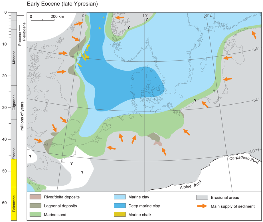
21Figure 4. Early Eocene (late Ypresian) palaeogeography, modified from Knox et al. (2010).
2.3. Oligocene
22The transition from the Eocene to the Oligocene is associated with a marked change in the pattern of uplift and subsidence in north-west Europe, reflecting a change in the regional stress regime. The complex pattern of sedimentation that characterised the Eocene was replaced by a more uniform pattern of basin-centred sedimentation. This change arose as a consequence of uplift of the western and north-eastern basinal margins (Knox et al., 2010).
23Following Early Eocene crustal separation, the Mid-Norway margin was partly inverted during the Late Eocene–Early Oligocene, from the Oligocene onward resultingin the near-shore areas being uplifted and deeply truncated (Holtedahl, 1953; Doré & Jensen, 1996; Clausen et al., 2000; Cloetingh et al., 2005). In Scandinavia, as in the Paleocene and the main sediment provenance were to the north and northeast during the Oligocene in contrast to the Eocene when the sediment was principally derived from the west (Clausen et al., 2000). In the Baltic region, combined uplift and southward tilting of the Fennoscandian Platform resulted in the establishment of a north to south palaeoslope exposing land areas that provided a new sediment source. This uplift is reflected in a marked change from eastward to predominantly massive westward progradation in the North Sea (Clausen et al., 2000; Huuse, 2002); sediments entered from the east rather than the west. The hiatus at the Eocene-Oligocene boundary in Belgium and other marginal successions is considered to result from regional uplift and inversion associated with the Pyrenean tectonic phase (Knox et al., 2010).
24During the Early Oligocene the eastern North Sea was occupied by southwards prograding deltaic deposits (Schiøler et al., 2007), reflecting the first evidence for the uplift of southernmost Norway which was subjected to substantial erosion at this time (Michelsen & Nielsen, 1993; Michelsen et al., 1998; Rundberg & Eidvin, 2005; Rasmussen, 2004). This initiated a marked change in sedimentation pattern (Anell et al., 2012). The uplift was associated with uplift in eastern areas of Scandinavia at that time, since amphibole and epidote-dominated sands occurred initially in the lowermost Oligocene sediments of north-west Poland (Kosmowska-Ceranowicz, 1988). The similarity of this heavy-mineral assemblage with that reported from the lowermost Oligocene of the Viborg Formation of Denmark (Vinken, 1988) suggests derivation from southern Sweden. This, combined with continued influx of epidote-rich sands from the north-east, resulted in deposition of epidote-rich sands on the Polish Platform (Morton et al., 1988).
25The first major sea-level fall resulting from the Oi-1 cooling event (De Man et al., 2004) led to widespread erosion of the previously deposited Early Oligocene marginal sediments. Substantial glacio-eustatic sea-level fall (Miller et al., 1998) at the Early-Late Oligocene (Rupelian-Chattian) boundary, accompanied by renewed tectonic activity, was superimposed on the palaeogeographical changes already initiated at the Eocene-Oligocene boundary (cf. Vandenberghe et al., 2012; Vandenberghe et al., 2014; Pekar & Miller, 1996; Fig. 5). Uplift and sea-level fall resulted in emergence of the entire Fennoscandian platform (Knox et al., 2010). This major regression phase, which saw large previously submerged areas exposed subaerially, allowed the extension of rivers across previously submerged marginal areas. The absence of any major sediment influx along the western North Sea Basin margin during the Late Oligocene indicates that the land area maintained a low relief (Gibbard & Lewin, 2003) (Fig. 5).
26The prevailing climate during the Early Oligocene was generally seasonally wet, hot, and tropical (Wilkinson, in Edwards & Freshney, 1982), although cooler conditions may have occurred on the higher areas (Tappin et al., 1994). This palaeogeographical pattern continued through the later, Neogene sea-level highstands.
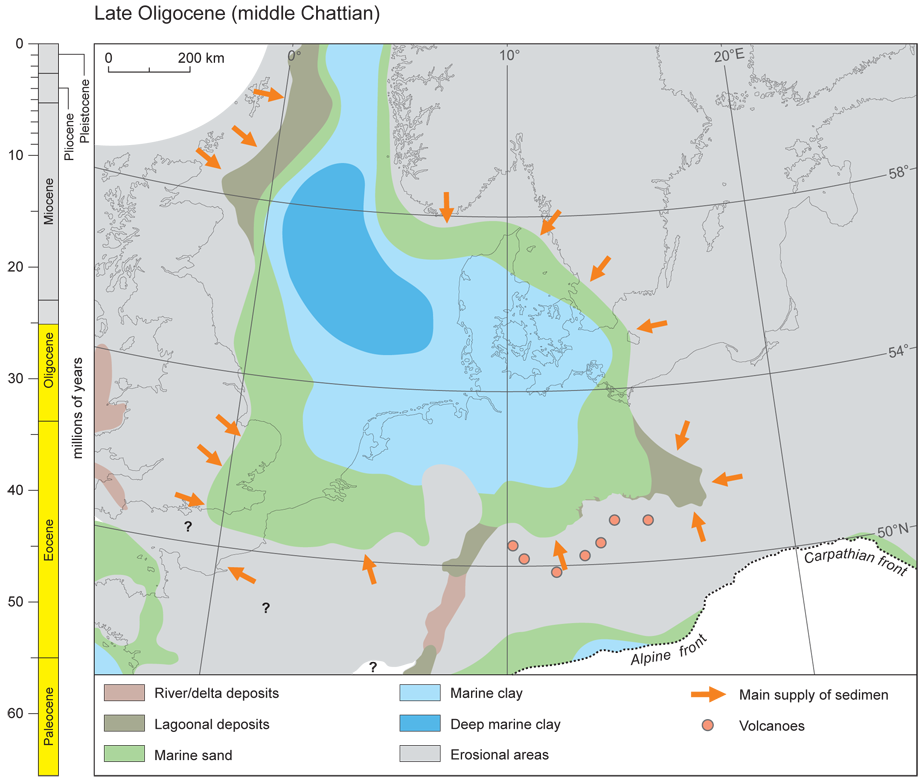
27Figure 5. Late Oligocene (middle Chattian) palaeogeography, modified from Gibbard & Lewin (2003) and Knox et al. (2010).
2.4. Neogene
28Substantial evidence for widespread Neogene uplift and tectonics around the northern Atlantic (e.g. Chalmers & Cloetingh, 2000; Japsen & Chalmers, 2000), occurring contemporaneously with increased subsidence and sedimentation in adjacent basins, has been established (Cloetingh et al., 1990, 2005). Throughout much of the southern North Sea basin margin the base of the Miocene is marked by a hiatus, thought to result from a combination of tectonic activity related to the mid- to late Miocene Savian Alpine phase and eustatic sea-level fall caused by the increased volumes of polar ice caps, particularly in Antarctica. The Savian phase was also marked by renewed inversion of the Sole Pit Basin (Van Hoorn, 1987) and the Sorgenfrei-Tornquist Zone (Rasmussen, 2009), by inversion on the southern flank of the Ringkøbing-Fyn High and in the Danish Central Graben (Rasmussen, 2009; King, 2006; Knox et al., 2010). It is probable that the Weald and Cleveland basins were also affected by inversion at this time. Although it has been suggested that the Weald Basin was substantially inverted during the Pyrenean (latest Eocene) tectonic phase (e.g. Ziegler, 1990; Ziegler & Dèzes, 2007). The timing is still debated (cf. King, 2006). The presence of Neogene marine sediments at an elevation of 180 m on the southern flank of the Weald anticline indicates relatively recent uplift in the Pliocene or Pleistocene. Similarly the occurrence of late Pliocene marine sediments at altitudes of up to 180 m a.s.l. on the margins of the London Basin (West, 1972; Balson, 1999) implies Early Pleistocene uplift of western and north-western Britain (cf. Gibbard, 1988).
29Within the North-west European Basin the Oligocene-Miocene unconformity is less distinct in the east than in the west, reflecting enhanced subsidence following the Savian tectonic phase. Increased sediment supply in the eastern basinal area, and especially in the North European Basin, was associated with the development of a Baltic River (Fig. 6). The catchment of this major river system included much of Fennoscandia, the Baltic States and westernmost Russia. Heavy-mineral evidence from the Polish succession shows a marked reduction in the epidote-bearing sand input from the Oligocene into the Miocene (Vinken, 1988; Kramarska, 2006; Knox et al., 2010). The amphibole and epidote-rich sands that had been deposited in the north-western Polish area during earliest Oligocene times are found further west in the Miocene (Vinken, 1988), indicating that the Baltic River flowed westwards along the trend of the present-day southern Baltic Sea basin (Fig. 6). This is consistent with Bijlsma’s (1981) record of the stratigraphic and geographical distribution of the distinctive Baltic Gravel Assemblage (cf. also Overeem et al., 2001), which largely consists of sedimentary rock types derived from the Lower Palaeozoic rocks of southern Scandinavia. There was a marked progradation across the Danish Shelf in the Early Miocene as a result of uplift and inversion combined with deposition of deltaic sediments of the Ribe, Bastrup and Odderup formations in the part of the North Sea basin beneath modern Denmark (Rasmussen, 2004). Heavy mineral studies demonstrate that the source area for the sand-rich deltas were present-day Finland, Sweden and particularly southern Norway and Sweden (Knudsen et al., 2005; Huuse, 2002; Knox et al., 2010). Coastal progradation also took place to the south following uplift of the Bohemian Massif and, to a lesser extent, in the Lower Rhine Graben (Fig. 6). The climate during most of the Early Miocene was changing from cool to warm temperate and frost was rare in the lowland areas (Rasmussen et al., 2008).
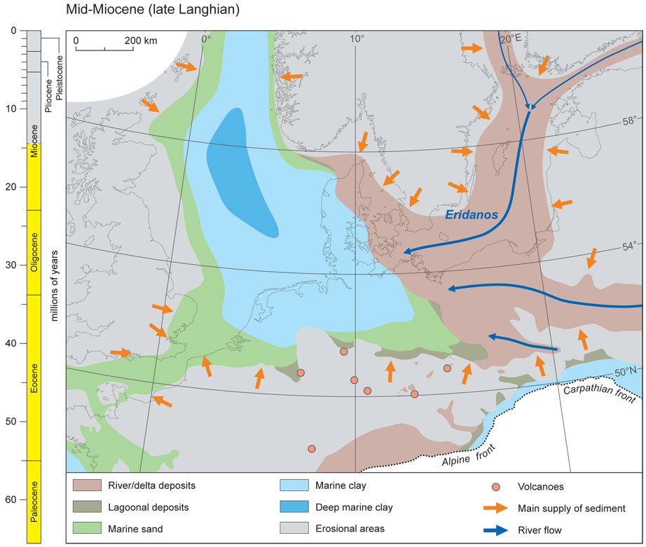
30Figure 6. Middle Miocene (latest Langhian) palaeogeography, modified from Gibbard & Lewin (2003) and Knox et al. (2010).
31The thick fluvial and associated sequences of the Lower Rhine Embayment (e.g. Schäfer et al., 2004) in western Germany, the Leipzig region of Eastern Germany, and the Belchatow region of Poland accumulated at this time. Although by no means restricted to the Neogene, the widespread sequences include brown coals or lignites. The fluvial sands and gravels, together with organic-rich clay beds, indicate that meandering rivers systems, associated with extensive and long-lasting peat accumulations, dominate the Neogene accumulations (e.g. Gleise, 1971; Eissmann, 2002). Channel-belt sediments dominated only part of the floodplain areas. Such sequences represent lowland deposition in partially coastal deltaic situations, particularly during the Mio-Pliocene of the Lower Rhine Embayment area, with fluvial progradation arriving in the Netherlands during the Tortonian (Martinius & Van den Berg 2011; Wong et al., 2007), the rivers draining subdued topography in central Europe.
32There is little information available for the western basin margin because of later Neogene uplift and erosion. However, the reworked marine Miocene fossils in phosphatic ‘lag’ gravels in East Anglia (Balson, 1990, 1999) suggest that sedimentation may have extended into south-east England, whilst westerly fine-clastic input from the proto-Forth and Tyne-Tees rivers is recorded in the Central North Sea (Gatliff et al., 1994).
33A widespread transgression took place during Mid-Miocene times, with marine facies extending over much of the Danish Shelf as far as south-west Poland (Fig. 6). This transgression was driven by a eustatic sea-level rise associated with the Mid-Miocene climatic optimum (~17 to 14 Ma: Zachos et al., 2001), but in the south-eastern embayment of the North Sea it appears to have been enhanced by subsidence associated with increased southward tilting of the Fennoscandian Platform. In the northern and eastern Polish areas, there was a marked increase in the area of non-marine sedimentation, with increased fluvial supply mainly from the east and north-east (Knox et al., 2010).
34A distinct change in the tectonic regime of the North Sea region occurred during the late Mid-Miocene, with accelerated uplift of Britain and Fennoscandia (Knox et al., 2010). This uplift apparently reflected the culmination of the tectonic regime change that had begun earlier in the Oligocene possibly driven by mantle processes (Cloetingh et al., 2005). Uplift of Fennoscandia, coupled with a marked deterioration in climate, led to a major increase in sediment supply to the south-eastern embayment of the North Sea via the Baltic River (Overeem et al., 2001), although sediment did not reach the southern North Sea until the Late Miocene (Knox et al., 2010; Rasmussen & Dybkjaer, 2014; Thöle et al., 2014). The South Swedish Dome also appears to have undergone relative uplift (Japsen & Bidstrup, 1999; Japsen & Chalmers, 2000; Lidmar-Bergström & Näslund, 2002; Japsen et al., 2007), while subsidence accelerated in the North Sea region (Fig. 6).
35According to Lidmar-Bergström et al. (2000), the relict 'Palaeic surface' of Scandinavia (Reusch, 1901) consists of high plains and broad valleys above 800 m a.s.l. Ancient exhumed surfaces occur on the flanks of the domal uplift. According to Rohrman et al. (1995) southwestern Norway was uplifted by as much as to 2 km during Neogene times. This uplift may be a continuation of updoming initiated in the Paleogene, associated with the opening of the North-east Atlantic Ocean, taking surfaces to levels nowadays at 1200 m, although it might have been initiated earlier in the Late Eocene-Early Oligocene. Consequent fluvial incision gave rise to valley incision as much as 300 m deep (Medvedev & Hartz, 2015), probably enhanced by a change to cool and wet climate in the Pliocene, and thus enhanced delivery of sediment to alluvial systems down-valley. A consequence of the uplift and climatic deterioration was increased sedimentation in the neighbouring basins beginning in the Miocene (Jordt et al., 1995). Continued incision to a depth of as much as 2 km below the palaeosurfaces is attributed to further climatic deterioration in the Quaternary when fluvial and glacial erosion resulted in 0.8 km uplift of rocks and up to a 0.5 km rise of local topography according to Medvedev & Hartz (2015). This was accompanied by further increased sedimentation in surrounding basins (Cloetingh et al., 2005).
36The pattern of uplift and subsidence established at that time has persisted to the present day, with a 1500 m-thick accumulation of sediment in the central North Sea since the Mid-Miocene. A widespread planation surface of presumed middle Miocene age (‘Reskajeage surface’) is recognised across western Britain and beyond (Walsh et al., 1987, 1996; Walsh, 1999). In north-east Scotland kaolin weathering took place in the middle Miocene under temperatures of 15 ± 5 °C (Hall et al., 2015). According to Rasmussen & Dybkjaer (2014) modern analogues of the Danish Miocene river systems are known from modern south-west India and therefore confirm that warm climates predominated. Despite this there is no suggestion that a monsoon-type climate prevailed, rather that simply high precipitation relative to today occurred.
37Uplift along the Weald-Artois axis appears to have finally led to closure of the Channel Seaway linking the North Sea southwards to the eastern Atlantic Ocean. The Baltic River deposits, characterised by the Baltic Gravel Assemblage, extended farther west during the Late Miocene (Bijlsma, 1981) flowing directly into north Germany under conditions of relatively rising sea level (Thöle et al., 2014). The substantial uplift, to which has been attributed a marked incision of river valley systems through the period, particularly in the Weald, (e.g. Jones, 1980; 1999a, b), is not confirmed by the sedimentary record (Gibbard & Lewin, 2003). Indeed the lack of major thicknesses of Neogene clastic sediments, in general, suggests that incision was not that intense throughout much of the region.
38Relative sea level is generally thought to have continued rising into the Early Pliocene (Fig. 7) (cf. Knox et al., 2010). During this time the Weald-Artois land-barrier might have been temporarily overtopped (cf. above) (e.g. van Vliet-Lanoë et al., 1998; Balson, 1999). The North Sea Basin experienced increase subsidence (cf. Cloetingh et al., 2005), whilst sedimentation continued to be dominated by the Baltic River, which supplied vast amounts of sediment to the south-eastern embayment, leading to continued offshore progradation (Overeem et al., 2001; Kuhlmann & Wong, 2008; Thöle et al., 2014). Elsewhere, the effects of relative sea-level rise were countered by continued uplift, most notably of the Scottish source areas, as shown by a major phase of southward land progradation. Shortly after, the shelf underwent uplift and erosion associated with a major phase of exhumation of Fennoscandia including the continued rise of the South Swedish Dome and southern Norway (Japsen & Chalmers, 2000; Lidmar-Bergström & Näslund, 2002; Japsen et al., 2002, 2007; Cloetingh et al., 2005). Discussions regarding the potential interplay of uplift and climatic deterioration of the Scandinavian mountains is still unresolved (e.g. Anell et al., 2009, 2012) but it is likely, given the influx of coarse clastic materials (Rundberg & Smalley, 1989), that glaciation was already established in the Norwegian mountains in Pliocene times (Ehlers et al., 2011; Medvedev & Hartz, 2015). The formation of the major elements of the preglacial landscape of Scotland, is thought to have occurred under the regime of warm to temperate humid climates during the Neogene (Hall & Bishop, 2002). The drainage system during the Pliocene was of braided character, depositing quartz-dominated gravels and sands derived from the west to north-west (Kesel & Gemmell, 1981; Hall et al., 2015). The occurrence of chemically resistant minerals and lithologies, such as quartz and flint, derived by long-term weathering under moist, warm-temperate climates, typify the fluvial bed products in the Miocene and Pliocene across the region, from the Baltic river system to the rivers of central Germany (Gibbard, 1988; Gibbard & Lewin, 2009) (Fig. 7). Indeed it appears that the foundations of the modern drainage system of northwestern Europe were laid in the Miocene under a persistent tectonic regime, with a subdued low-relief landscape having a weathered regolith and dense vegetation cover. In general, these early rivers occupied shallow valleys.
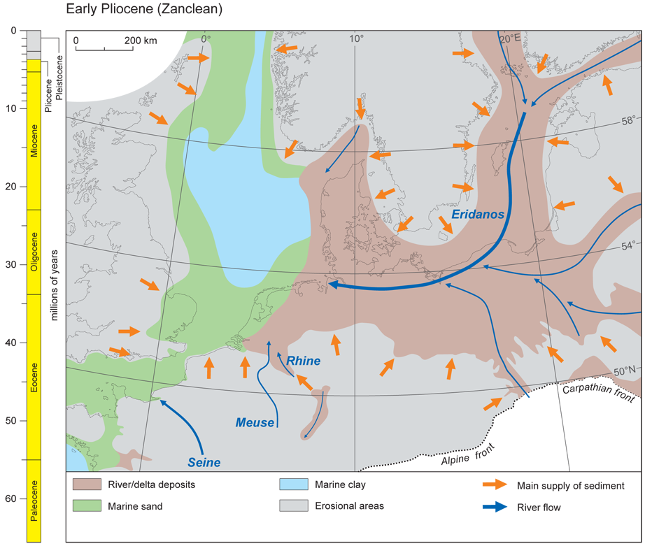
39Figure 7. Early Pliocene (Zanclean) palaeogeography, modified from Gibbard & Lewin (2003) and Knox et al. (2010).
2.5. Pleistocene
40Subsequent early Pleistocene uplift of western, north-western and northern Britain caused a relative displacement of ca. 180 m between the western London Basin and the Suffolk coast (Mathers & Zalasiewicz, 1988). The resulting regression allowed the east and north-eastwards expansion of the River Thames system to occupy the basin vacated by the sea (Gibbard, 1988). Further north-east, precursors of the Trent, Humber and Tyne-Tees were present (Cameron et al., 1992), as well as off the eastern Scottish coast. Likewise in the Early Pleistocene the Eridanos (Baltic) River delta complex continued to expand west and later north-westwards in the Netherlands' North Sea sector (Fig. 8). During this time the depositional evolution was strongly influenced by climatic variations and resulting sea-level changes (Funnell, 1996; Overeem et al., 2001; Kuhlmann & Wong, 2008; Thöle et al., 2014). Glaciation occurred periodically in the region from the Plio-Pleistocene boundary times and through the later Pleistocene (Thierens et al., 2012; Ottesen et al., 2014; Sejrup et al., 1995) causing landscape remodelling and frequent reorganisation of drainage systems on adjacent land areas (cf. Gibbard & Cohen, 2015; Cohen et al., 2014). During the Middle to Late Pleistocene river incision greatly increased apparently in response to the increasing severity and longer duration of cold climates (Gibbard & Lewin, 2009).
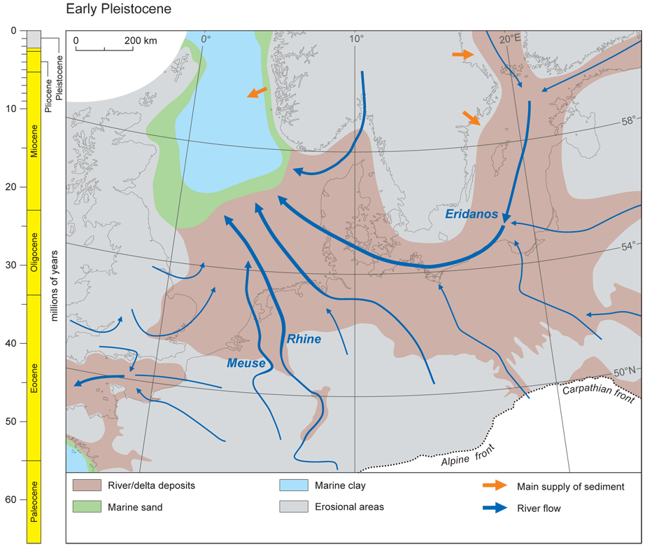
41Figure 8. Pre-glacial Pleistocene palaeogeography, modified from Gibbard (1988), Knox et al. (2010) and Thöle et al. (2014).
42By the early Middle Pleistocene (ca. 1 million years ago), the glacial-interglacial climate oscillations became more profound than previously leading to the development of substantial ice sheets in the Alps, Scandinavia, Wales and Scotland at this time (Head & Gibbard, 2015). Although glaciation had advanced into the lowland regions surrounding the Baltic by ca. 650 ka, it was not until the Anglian (Elsterian) Stage that ice sheets overrode the North Sea basin, southern Britain and northern Germany (Ehlers et al., 2011) (Fig. 9).
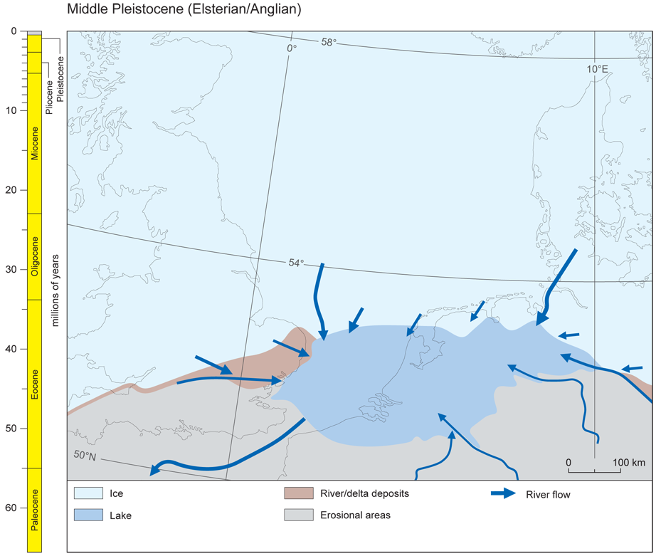
43Figure 9. Glacial Pleistocene (Anglian-Elsterian stage) palaeogeography, modified from Gibbard (2007).
44By the Middle Pleistocene, the Rhine had become an important element in the southern North Sea region as its catchment progressively increased. The Rhine deltaic complex by this time had filled the central and southern North Sea, the southern North Sea having become a land area. To the south, the Weald-Artois anticlinal structure formed a substantial barrier separating the North Sea from the Channel. North of this structure the major drainage lines entered the North Sea basin. On the eastern side, the northern (Eridanos or Baltic) river system had lost the connection to the Fennoscandian and Baltic headwaters. This implies that the Baltic basin had been formed, probably by intensified ice-sheet erosion. Nevertheless, major input sediment occurred along this course within the North European Basin, from Scandinavia, the Baltic States and the north German rivers, and in the North Sea area with the Rhine, Meuse, Scheldt and Thames. This input during the Middle Pleistocene was also potentially increased by the accelerated uplift of the Ardennes-Rhenish massif by up to 600 m which had begun in the Miocene (Van Balen et al., 2000, 2005). Sediment accumulated in the Roer Valley Graben which had subsided by a similar order.
45South of the Weald-Artois interfluve the drainage systems, the rivers of northern France, especially the Seine, joined those from Britain to form the substantial Channel River system (or Fleuve Manche) which occurred on the floor of the basin during low sea-level stands.
46A major change occurred ca. 450 ka ago in the Anglian (Elsterian) Stage (Fig. 9). During this glaciation ice from southern Norway crossed the North Sea and overrode easternmost Britain to deposit a complex of glacial sediments (Gibbard, 1995). This complex includes not only diamicton but glaciolacustrine sediments, including stratified diamictons that accumulated beneath a floating ice-front (Lunkka, 1994; Gibbard & van der Vegt, 2012), these sediments indicating the occurrence of a massive proglacial lake in the unglaciated southern North Sea basin (Gibbard, 1988, 1995; Cohen et al., 2014). This ice sheet across the basin blocked the drainage systems, whilst the topographic barrier to the south (Weald-Artois anticline) between Kent and northern France, caused an extensive lake to form (Belt, 1874; Gullentops, 1974; Gibbard, 1988, 1995, 2007; Hijma et al., 2012; Cohen et al., 2014).
47The overspill of this lake occurred at what is now the Straits of Dover (Pas de Calais). A saddle-like topographic feature on the Chalk topography, on the drainage divide presumably functioned as the threshold over which overspill occurred. To the north, the lake water level behind this saddle reached a maximum of ca. 30 m above present sea level. Overspill of the lake initiated a spillway that was rapidly incised, huge quantities of sediment being evacuated southwards into the Channel river, the finest material being transported onto the lower shelf, the shelf front and ultimately the abyssal fans on the adjacent Atlantic Ocean floor.
48However, the dramatic erosion of the Straits of Dover area is not thought to have taken place during one, but two major glacially-driven erosional episodes. Although substantial erosion took place during the Anglian glaciation, it is now known that it took a second major glaciation of the southern North Sea, comparable in extent to the Anglian, to form a second proglacial lake which restarted the retrogressive erosion, to complete the connection of the North Sea and English Channel drainage (Gupta et al., 2007; Gibbard, 2007; Hijma et al., 2012; Cohen et al., 2014).
49This second event occurred ca. 160 ka ago during the Saalian (= Wolstonian) Stage glaciation (within MIS 6). During this phase British and Scandinavian ice lobes again met across the North Sea (Ehlers & Gibbard, 2004). On the Netherlands' side, the Saalian glaciation reached further south than any previous glaciation. To the south of the ice-front a topographic ridge across the southern North Sea occurred contemporaneously with braided-river deltaic features from the ice-marginal river Rhine (Busschers et al., 2008). A similar delta complex is seen in western Belgium (Mathys, 2009). These deltas formed in a proglacial lake, the water level of which is estimated at a maximum of ca. +5 m. Mapping of the North Sea floor between the Netherlands and Britain has demonstrated the continuity of this Saalian ice-limit across the North Sea basin. Also, the abyssal record off the English Channel continental slope shows sediment delivery peaks in MIS 6 (at ca. 160 ka ago) that rival that of MIS 12 (at ca. 450 ka) (Toucanne et al., 2009). This evidence demonstrates the contemporaneous occurrence of a lake during the Drenthe Substage maximum glaciation in the Saalian (and equivalent part of the Wolstonian).
50The opening of the Dover Straits initiated diversion of the rivers (Gullentops, 1974; Gibbard, 1988). Following drainage of the Anglian glacial lake, the Belgian rivers and the Thames, were redirected into the Channel River. However, it was not until after drainage of the lake formed in the subsequent Saalian glaciation that the Rhine and Meuse were realigned to the south where they joined the rivers through the Dover Straits (Busschers et al., 2008; Hijma et al., 2012). The glacioeustatic sea-level fall at the transition to the last glacial (Weichselian/Devensian Stage), allowed the Dover Straits to be reoccupied by this substantial river system. Periodically the Rhine-Thames Channel River also carried meltwater from the British and Scandinavian ice sheets, although this was episodic, for most of the time the outwash drained northwards.
51As noted above, the Baltic basin was probably initiated by intense glacial erosion that began late in the Early Pleistocene (ca. 1.2 Ma) based on the occurrence of glacial erratics in the Netherlands Hattem Beds (Zandstra, 1971) and in early Middle Pleistocene glacial diamictons in Poland, the Baltic States and the Russian plain (Marks, 2004; Ehlers & Gibbard, 2004). The earliest marine sediments preserved in the Baltic basin are of Holsteinian (i.e. late Middle Pleistocene, ca. 380 ka) age. They are known from northern Germany, Poland, Kaliningrad Oblast and as far north as the Bay of Riga (Marks & Pavlovskaya, 2003).
3. Fluvial styles through the Cenozoic
52It is possible in general terms to suggest some conclusions about the changing river networks and styles of fluvial sedimentation as the North Sea area developed. These styles reflect the tectonics and climates at particular times, though linkage to single causative factors is seldom possible. For example, high-energy river discharges may reflect both steep catchment gradients (relating to uplift), but also high runoff, both of which may be linked to the other for high relief areas.
3.1. Paleocene
53A major proto-Thames system entered the London Basin (e.g. Wells & Kirkaldy, 1966; Wooldridge & Gill, 1925; Wooldridge & Ewing, 1935) in the late Thanetian. Its low-energy clay-dominated, floodplain accretionary sediments, locally with lignite units up to 1 m thick (Hester, 1965), occur as predominantly fining-upward sequences formed by a series of meandering rivers. The river was transporting pebbly sand to clay-sized material and forming a major delta complex. The flow channel itself was dominated by sands, with clay-plug type abandoned channel fills and notably clay-clast breccias. The multi-coloured mottled clays, pedologically-modified and associated lignitic units, and sedimentation typically found in vertically–accreted floodplain sequences, are associated with fining-upward channel fills and point-bar accumulations. The clay-clast breccias are said to typify meandering river sediments in tropical regions (Miall, 1996), but low-energy humid environments more generally (sub-tropical and temperate) show similar characteristics. Here rivers have cohesive banks, densely-vegetated floodplains, and predominantly transport fines but also clay clasts during floods.
3.2. Eocene
54The nature of the land surface during London Clay times is poorly known but appears to have remained subdued with wide plains (e.g. Wells & Kirkaldy, 1966; Daley, 1972). Slow degradation of exposed surfaces subjected to intense chemical weathering is reflected in the vast volumes of clay which may have been produced by extended earlier weathering and supplied to the basinal areas by the rivers from the north and west.
55London Clay deposition ended with the rapid expansion of fluvial delta complexes towards the east in the late Ypresian–Lutetian (early Middle Eocene) times. This transition is signalled by the sand-silt alternations of the Claygate Beds and the subsequent accumulation of the overlying Virginia Water-Bagshot Formation sands in the west representing a vast delta complex (Wells & Kirkaldy, 1966; Anderton, 2000). The sediments consist of cross-bedded sands, with thin clay or silt partings and thin pebble beds, becoming considerably coarser towards their western limit. This transition from the London Clay to the overlying sands may reflect either depression of the basin, or uplift of the hinterland further west and north-west, which encouraged river incision and potentially increased catchment yields of coarser terrigenous sediments. No later Paleogene fluvial or estuarine sediments occur in the London Basin.
3.3. Oligocene
56No younger Paleogene sediments are known from the London Basin, but they do occur in the Hampshire-Dieppe Basin and further west. Here palaeobotanical investigations demonstrate a distinct shift from the post-Bartonian subtropical/ very warm temperate conditions to cooler climate (Machin, 1971; Collinson, 1983; Collinson & Cleal, 2001a/b). Fluvial sediments in Denmark draining the southern Scandinavian peninsula have been thought to adopt a braided form. Massive fluvial sand was deposited in the basinal setting during the Upper Oligocene which led to substantial westward shoreline migration (Rasmussen, 1998). In the Lower Rhine system, by contrast, fluvial sands and gravels, together with intercalated organic-rich clay beds, were laid down by meandering rivers (e.g. Eissmann, 2002). These sequences represent lowland deposition in partially coastal deltaic situations, particularly during the Mio-Pliocene of the Lower Rhine Embayment area (Gleise, 1971; Gleise & Hager, 1978; Zagwijn, 1989; Zagwijn & Hager, 1987), the rivers draining subdued topography in central Europe.
3.4. Neogene and Quaternary
57In situ Miocene deposits are virtually absent from Britain, whereas they are present in neighbouring continental countries, including Germany, Poland and the Netherlands. In the Central North Sea, westward input of fine-clastics from precursors of NE English and Scottish rivers occurred (Gatliff et al., 1994). These sediments joined the substantial input from the prograding Baltic (‘Eridanos’) deltaic system from the south and south-east, first seen in late Miocene times (Zagwijn, 1974; 1979; Cameron et al., 1992; Funnell, 1996; Huuse, 2002; Overeem et al., 2001; Rasmussen et al., 2008; Thöle et al., 2014). The deposits of this river system are generally not exposed in the North Sea region, but in Lithuania equivalent deposits spanning the late Miocene to Middle Pleistocene occur in the south-east and in neighbouring Russia (Kaliningrad Oblast) and Belorussia. Here thePliocene-ageAnyksciai Formation is overlain by the Early Pleistocene Daumantai Formation, both of which comprise quartz sands with subordinate silt, clay and lignite channel fills. The Anyksciai Formation (Upper Pliocene) is characterised by a 'Neogene-continental' heavy-minerals association, which comprises maximum values of stable minerals including quartz (95%), zircon (3.4%), staurolite (6.7%), iron oxides and hydroxides (9.6%). The overlying Daumantai Formation is represented by fine-grained sand, silty sand with interlayers of silt, and more rarely by interbedded clay and sand. Organic material and wood characteristically also occur in the Daumantai deposits. Unstable heavy minerals of the magnetite-garnet-amphibole association characteristically occur at low frequencies in the Daumantai sands, indicating that during their formation input of Scandinavian material took place. The implication of this is that during the Daumantai period the supply of Scandinavian erratic material increased as a result of glaciation in headwater areas (Satkunas, 1998).
58According to Thöle et al. (2014) in the latest Miocene, the Baltic River delta was dominated by flow from the east, including increasing input from the North German rivers. Although Burger (2001) distinguished three heavy mineral assemblages in the Late Miocene deposits, reflecting different river system sources, only southern Norway could be specifically identified. Apart from the Scandinavian provenances, this author noted a potential increased contribution from the south-east, i.e. eastern Germany, Poland and the Czech Republic. Thöle et al. (2014) note that uplift of the Western Carpathian and Eastern Sudetes occurred at this time (Badura & Przybylski, 2004), initiating major reorganisation of the drainage system. This resulted in re-alignment of the formerly southward-directed drainage northwards to the North Sea Basin, the Carpathians and Sudetic rivers most probably becoming southbank tributaries of the Baltic River System (Badura & Przybylski, 2004).
59In detail the sediments comprise sands and fine gravel with subordinate fine-grained sediment laminae predominant. The former occur as incomplete fining-upward cycles filling shallow channel-like depressions often dissecting elongate stratified sand and silt horizontally-bedded units. Occasional fills of silt, and more rarely, silty clay occur in elongate lenticular form. Associated with these fine sediments are peat-like lignite beds, especially in the pre-Quaternary strata. Overall the facies association resembles that of a sand-dominated multiple-channelled braided river.
60Coarse-grained sediments from the upper units and some of the river deposits show evidence for different source area composition. The shift from warm Pliocene towards cold, Pleistocene climate conditions and the intensification of glaciation in the Baltic River catchment are also seen in the equivalent sediments in the Netherlands where this is expressed by the increase of unweathered illite and a decrease of smectite and kaolinite content (Kuhlmann et al., 2004). The progressive gradual reduction in the inherited regolith thickness through the course of Pliocene to Early Holocene time resulted in expanding areas where pre-Tertiary and pre-Mesozoic bedrock became exposed. These began contributing minerals to the fluvial sediments.
61The vegetational evidence indicates a predominantly coniferous-forested landscape. However, species-rich forests probably continued during the Anyksciai time; certain intervals of steppe-forest occurred, probably reflecting periods of climatic deterioration. By contrast, vegetation during deposition of the Daumantai deposits was characterized by temperate forests indicating a cool, humid climate.
62Sediment production from the Fennoscandian shield peaked during the cold and highly fluctuating climate of the Late Pliocene–Pleistocene. Although a tectonic uplift component has been proposed by many authors (Japsen & Chalmers, 2000; Overeem et al., 2001; Dahlgren et al., 2005; Stoker et al., 2005), Golzdowski et al. (2012) suggest that the Plio-Pleistocene erosion history of Scandinavia (and therefore of offshore sedimentation) is solely a result of the colder climate with more abundant periglacial process-dominated denudation, increased seasonality, glaciation and ice sheet overriding of watersheds. Some authors have considered the increased sediment supply could result from a combination of the two processes (e.g. Anell, 2009, 2012), but it remains unclear whether uplift was a response to the accelerated denudation of subdued and heavily weathered Tertiary landscapes driven by climate change, or was unrelated to climate. Comparison with the impact of the cold-climates of the later Pleistocene strongly supports the climatic interpretation (cf. below).
63As already discussed, the thick fluvial and associated Neogene and earlier age sequences of the Lower Rhine Embayment in western Germany and the Netherlands, the Leipzig region of Eastern Germany, and the Belchatow region of Poland include substantial fluvial sequences that were laid down by meandering rivers systems (e.g. Gleise, 1971; Eissmann, 2002) draining lowland areas and feeding coastal deltas, particularly during the Mio-Pliocene (Gleise, 1971; Gleise & Hager, 1978; Zagwijn, 1989; Zagwijn & Hager, 1987). Continuing the pattern established throughout much of the Cenozoic, these rivers drained a subdued topography that dominated central Europe at this time. The extensive, diverse, densely-forested environments of subtropical character appeared to alternate with more temperate episodes that were characterized by an ‘arcto-Tertiary flora’ dominated by deciduous temperate forest (Zagwijn & Hager, 1987; Zagwijn, 1992). During the Pliocene this arcto-Tertiary flora became predominant (Zagwijn, 1992; Eissmann, 2002).
64The transition to the Pleistocene saw the dominance of cold, generally periglacial climates across the region. During this period, rivers, in common with those of modern periglacial environments, adopted braided, meandering, straight, and anastomosing channel forms (van Huissteden et al., 2013). Throughout the period, episodes of river incision and deposition occurred during cold-climate periods. Of particular importance is the dramatic change seen throughout the region corresponding to the so-called Middle Pleistocene Transition (1.2-0.8 Ma). This appears to have given rise to the modern, deeply incised river valleys that characterise the region. The strong contrast of these valleys with the shallow valleys predominant during the Neogene, strongly suggests that enhanced fluvial activity was a result of the occurrence of cold climates and the supply of abundant fresh materials by periglacial slope processes. In general the fluctuating climates of the later Pleistocene with periglacial conditions, frost-weathered bedrock and seasonally-focused runoff, are likely to have dominated extra-glacial landforming processes, in particular being responsible for bedrock incision. The relatively brief episodes of glaciation within cold periods, in the peripheral regions, were potentially aggradational, and interglacial periods were broadly ones of quiescence (Gibbard & Lewin, 2009; van Huissteden et al., 2013). Whilst this picture might be biased by the record preserved principally from river valley environments, coastal or deltaic areas were less quiet in erosional/depositional terms during temperate-climate events.
4. Discussion and Synthesis
65Through the last 60 My the southern North Sea has migrated from 42° to 52° North resulting in the region passing through a range of climatic zones from tropical to temperate climates (van Hinsbergen et al., 2014). Meandering streams dominate throughout the pre-Quaternary period in lowland areas of the North Sea region, the evidence conforming generally to Miall’s (1996) models for rivers in seasonal tropical/sub-tropical/warm-temperate situations. Although their form will inevitably have varied locally depending on materials in transport, discharge variability and variations in slope, the overall stability in fluvial form is striking across the lowland regions before the second half of the Pleistocene. This appears to relate to the subdued relief that seems to have prevailed, to stability of regolith and its replacement under a dense vegetation cover, and to predominance of fine particulate materials in transport. From the British side of the North Sea, it is clear that during certain periods, e.g. the late Ypresian to Lutetian or the middle Thanetian, the rivers were predominantly transporting clastics, sand and silt derived from destruction of the uplifting hinterland to the west, particularly Palaeozoic and Pre-Cambrian massifs, resulting in great expansions of sand-rich deltas. This is perhaps analogous to some tropical rivers today, like the Andean headwaters of the Amazon, whereas the river’s cratonic tributaries are more typically meandering but respond to variations in sediment load (Constantine et al., 2014).
66By contrast, during the early Ypresian, the dominant load was clay, derived from the thick weathering crusts and associated volcanic materials indicated by the high content of smectite following intense pyroclastic activity produced by Thulean flood basaltic eruptions derived from the Icelandic plume. This was associated with the opening of the Atlantic Ocean and this impacted on the whole of NW Europe (Brodie & White, 1994; Knox, 1996; Cloetingh et al., 2005; Knox et al., 2010). This was deposited as London Clay when a period of comparative structural quiescence coincided with the maximum of Paleogene marine transgression. Where channel and floodplain complex depositional sequences are preserved, e.g. the late Thanetian, a mixed load of fine granular material, together with sands, fines and locally clay-breccias was transported. In almost all the cases described, vegetation played a profoundly important role. Repeatedly descriptions of lignite (peat), which may be associated with floodplain sequences, are reported. Such rivers are more characteristic of low-migration channels bordered by wetlands as found in the lower Amazon, and rivers that do not directly fill their valleys with lateral accretion deposits (Maurice-Bourgoin et al., 2007; Lewin & Ashworth, 2014). Other restricted mineral corridors with bordering organic wetlands and lacustrine systems occupying valley floors have been reported from the Paraná system in Argentina and in Papua New Guinea (Iriondo et al., 2007; Day et al., 2008). In most cases the dense vegetation can be assumed to have greatly contributed to bank cohesion and stability; a situation typically found in tropical, sub-tropical and warm-temperate environments alike.
67In Britain, identification of floodplain surfaces has been repeatedly represented by descriptions of palaeosols, mostly originating under moist, but seasonally dry conditions, e.g. in the Hampshire Basin Reading Beds (Paleocene), the Headon Hill Formation (late Middle to Late Eocene), in the Bovey Formation (Oligocene) and in the Lignite and Clay Unit (Oligocene–Early Miocene) in the Cardigan Bay Basin.
68Gravel (conglomerate) accumulations are extremely rare in the regional northern European Cenozoic alluvial sequences. Whilst braided sheet-flood sequences occur in the upland regions of Britain (Gibbard & Lewin, 2003) coarse aggradations were apparently restricted to areas of high relief or active uplift such as Scotland, Norway and northern Denmark. The general persistence of subdued topography implies that rivers throughout much of the period lacked sufficient potential energy, or proximal mountain sediment sources, to generate flows capable of moving coarse materials. The implication is that even under conditions of precipitation higher than that today (e.g. Daley, 1972; Haywood et al., 2000), storm-induced floods rarely caused transport of gravel-sized material. The density of the vegetation cover throughout must have acted to reduce the impact of flood, supported by efficient groundwater percolation (Gibbard & Lewin, 2009). Moreover, the predominance of intense chemical weathering may have resulted in coarse gravel-sized material being absent from catchments. Nevertheless sand-dominated accumulations occur throughout the period across the region, indicating that this material, often composed predominantly of chemically stable mineral assemblages, was being transported throughout the region. This is characteristic of many humid river systems today beyond the influence of prior cold-climate weathering.
69Humid rivers simply being characterized as 'tropical' can be misleading: in the warm inter-tropical convergence zone (ITCZ), they may receive intense but localized daily convective rainfall, with annual and daily insolation variations, and seasonal monsoons with ITCZ migration. Chemical weathering may be intense, producing clay sediments. Year to year variation may be comparatively subdued within most of the tropics, but considerable in sub-tropical monsoon regimes and cyclone-liable regions. Mid-latitude rainforest may not have the same characteristics as tropical rainforest.
70Small rivers respond to intense localized rainfall; large ones respond smoothly to seasonal fluctuations. Lower water viscosity at warm temperatures reduces fine sediment transport by between 3 and 0.35% per 10° rise in temperature depending on particle size (Syvitski et al., 2014). Tropical river regimes with the present-day distribution of continents, mountains and oceans are distinctive. But without relief and with a cover of rainforest, cratonic rivers like the Congo may be low sediment-yielding (Latrubesse et al., 2005, table 2), and this is likely to have applied to the former Eridanos until tectonic uplift affected its tributaries.
71In spite of the view that uplift might explain the large increase in sedimentation in the latest Cenozoic that began at ca. 2.5 Ma, comparison with later fluvial activity implies that it almost certainly reflects climatic deterioration (review inGibbard & Lewin, 2009). A substantial change marked the beginning of the Quaternary, with glaciation extending to lower altitudes and sea-level in southern Norway and periglacial frost-dominated climates becoming established over the region. An even greater impact occurs in response to further intensification of cold climates following the Middle Pleistocene Transition (Gibbard & Lewin, 2009; Head & Gibbard, 2015). There is a Pleistocene incision question concerning drivers, feedbacks and timings. Did cold-climate and accelerated erosion lead to removal of mass, consequent tectonic uplift, and hence positive feedback with further linear incision? Some have also coupled uplift to near-contemporary late Quaternary neotectonics or glaciotectonics (Antoine et al., 2000). Or did climate and accelerated activity simply permit greater climate-driven and episodic linear erosion in elevated areas that were in any case prepared tectonically by uplift over the longer term (Antoine et al., 2007; Van Balen et al., 2000)?
72Throughout much of Europe, low-relief land surfaces dominated the southern regions until the Plio-Pleistocene. The tectonic regime operating in north-west Europe remained broadly the same throughout the Cenozoic, although the progress of erosion and deposition around the North Sea Basin were sufficient to drive substantial developments throughout the period, with sediment inputs coming from different quarters and with different river styles. In the broadest terms, there has been a clockwise shift in sediment sources at first from the northwest, then Scandinavia, then to a now- disappeared Eridanos River and finally to the Rhine-Meuse system.
73Today’s river valleys, deeply incised during the Pleistocene, almost certainly result from efficient erosion at such times, with high andpredominantly coarse to very coarse sediment yields resulting from frost-dominated climates (cf. Anell et al., 2012; Cloetingh et al., 2005; Gibbard & Lewin, 2003, 2009). This is notwithstanding the continuing impact of regionally important factors, such as local tectonics, lithologies and relief. The general depletion of regolith generated earlier in the Neogene, faster than it could be replaced and coupled with accelerated weathering, contributed substantially to the activity and materials in transport by rivers. This change resulted from amplification of external climate and tectonic changes occurring at the time. The frequent thinning and occasional disappearance of the vegetation cover and the altered conditions for channel-bed and valley-floor incision that accompanied these changes explain the later Pleistocene landscape dissection (Gibbard, 1988).
5. Acknowledgements
74The authors thank the Executive Committee of Geologica Belgica for inviting them to submit this article. They are particularly grateful to Dr Vanessa Heyvaert and Dr Wim Westerhoff for their support and encouragement. We are grateful to Dr K.M. Cohen and Professor N. Vandenberghe for their help in improving the text. The figures were drafted by Philip Stickler and Silas Tull (Department of Geography, University of Cambridge). Finally, the support and advice of the editor and production staff of the Geologica Belgica are gratefully acknowledged.
6. References
75Amantov, A., Fjeldskaar, W. & Cathles, L., 2011. Glacial erosion/sedimentation of the Baltic region and the effect on the postglacial uplift. In Harff J., Björk S. & Hoth P. (eds), The Baltic Sea Basin. Springer, Berlin. Central and Eastern European Development Studies (CEEDES), 53-71.
76Anderton, R., 2000. Tertiary events: the North Atlantic plume and Alpine pulses. In Woodcock, N.H. & Strahan, R.A. (eds), Geological history of Britain and Ireland. Blackwell, Oxford, 374-391.
77Anell, I., Thybo, H. & Artemieva, I.M., 2009. Cenozoic uplift and subsidence in the North Atlantic region: Geological evidence revisited. Tectonophysics, 474, 78-105.
78Anell, I, Thybo, H. & Rasmussen, E., 2012. A synthesis of Cenozoic sedimentation in the North Sea. Basin Research, 24, 154-179.
79Antoine, P., Lautridou J.P. & Laurent M., 2000. Long-term fluvial archives in NW France: response of the Seine and Somme rivers to tectonic movements, climate variations and sea-level changes. Geomorphology, 33, 183-207.
80Antoine, P., Limondin Lozouet, N., Chaussé, C., Lautridou, J-P., Pastre, J-F., Auguste, P., Bahain, J-J., Falguères, C. & Galehb, B., 2007. Pleistocene fluvial terraces from northern France (Seine, Yonne, Somme): synthesis, and new results from interglacial deposits. Quaternary Science Reviews, 26, 2701-2723.
81Badura, J. & Przybylski, B., 2004. Evolution of the Late Neogene and Eopleistocene fluvial system in the foreland of the Sudetes Mountains, SW Poland. Annales Societatis Geologorum Poloniae, 74, 43-61.
82Balson, P.A., 1990. The ‘Trimley Sands’: a former marine Neogene deposit from eastern England. Tertiary Research, 11, 145-158.
83Balson, P., 1999. The Neogene of eastern England. In Daley, B. & Balson, P. British Tertiary stratigraphy. Joint Nature Conservation Committee, Peterborough. Geological Conservation Review series No. 15, 235-240.
84Belt, T., 1874. Glacial Period. Nature, 10, 62-63.
85Bijlsma, S., 1981. Fluvial sedimentation from the Fennoscandian area into the Northwest European Basin during the Late Cenozoic. Geologie en Mijnbouw, 8, 337-345.
86Brodie, J. & White, N., 1994. Sedimentary basin inversion by igneous underplating, North -west European continental shelf. Geology, 22, 147-150.
87Burger, A., 2001. Heavy minerals in the Nieder Ochtenhausen Borehole. Geologisches Jahrbuch, 152, 141–157.
88Busschers, F.S., Van Balen, R.T., Cohen, K.M., Kasse, C., Weerts, H.J., Wallinga, J. & Bunnik, F.P., 2008. Response of the Rhine–Meuse fluvial system to Saalian ice‐sheet dynamics. Boreas, 37, 377-398.
89Cameron, T.D.J., Crosby, A., Balson, P.J., Jeffery, D.H., Lott, G.K., Bulat, J. & Harrison, D.J., 1992. The geology of the southern North Sea. United Kingdom offshore regional report. British Geological Survey. Her Majesty’s Stationery Office, London.
90Caston, V.N., 1977. Quaternary deposits of the central North Sea: 1, A new isopachyte map of the Quaternary of the North Sea; 2, The Quaternary deposits of the Forties field, northern North Sea (Vol. 1). Her Majesty’s Stationery Office, London.
91Chalmers, J.A. & Cloetingh, S. (eds), 2000. Neogene uplift and tectonics around the North Atlantic. Global and Planetary Change, 27, 1-173.
92Clausen, O.R., Nielsen, O.B., Huuse, M. & Michelsen, O., 2000. Geological indications for Palaeogene uplift in the eastern North Sea Basin. Global and Planetary Change, 24, 175–187.
93Cloetingh, S., Thybo, H. & Faccenna, C., 2009. TOPO-EUROPE: Studying continental topography and Deep Earth—Surface processes in 4D. Tectonophysics, 474, 4-32.
94Cloetingh, S.A.P.L., Gradstein, F.M., Kooi, H., Grant, A.C. & Kaminski, M.M., 1990. Plate reorganization: a cause of rapid late Neogene subsidence and sedimentation around the North Atlantic? Journal of the Geological Society, 147, 495-506.
95Cloetingh, S.A.P.L., Ziegler, P.A., Beekman, F., Andriessen, P.A.M., Matenco, L., Bada, G., Garcia-Castellanos, D., Hardebol, N., Dèzes, P. & Sokoutis. D., 2005. Lithospheric memory, state of stress and rheology: neotectonic controls on Europe's intraplate continental topography. Quaternary Science Reviews, 24, 241-304.
96Cohen, K.M., Gibbard, P.L. & Weerts, H.J.T., 2014. North Sea palaeogeographical reconstructions for the last 1 Ma. Netherlands Journal of Geosciences - Geologie en Mijnbouw, 93, 7-29.
97Collinson, M.E., 1983. Palaeofloristic assemblages and palaeoecology of the Lower Oligocene Bembridge Marls, Hamstead Ledge, Isle of Wight. Botanical Journal of the Linnean Society, 86, 177-225.
98Collinson, M.E. & Cleal, C.J., 2001a. The palaeobotany of the Palaeocene and Palaeocene-Eocene transitional strata in Great Britain. In Cleal, C.J., Thomas, B.A., Batten, D.J., Collinson, M.E. (eds), Mesozoic and Tertiary palaeobotany of Great Britain. Geological Conservation review Series No. 22, Joint Nature Conservation Committee, Peterborough, 155-184.
99Collinson, M.E. & Cleal, C.J., 2001b. Late Middle Eocene-early Oligocene (Bartonian-Rupelian) and Miocene palaeobotany of Great Britain. In Cleal, C.J., Thomas, B.A., Batten, D.J., Collinson, M.E. (eds), Mesozoic and Tertiary palaeobotany of Great Britain. Geological Conservation review Series No. 22, Joint Nature Conservation Committee, Peterborough, 227-274.
100Constantine, J.A., Dunne, T., Ahmad, J., Legleiter, C. & Lazarus, E.D., 2014. Sediment supply as a driver of river meandering and floodplain evolution in the Amazon Basin. Nature Geoscience, 7, 899-903.
101Dahlgren, K.T., Vorren, T.O., Stoker, M.S., Nielsen, T., Nygård, A. & Sejrup, H.P., 2005. Late Cenozoic prograding wedges on the NW European continental margin: their formation and relationship to tectonics and climate. Marine and Petroleum Geology, 22, 1089-1110.
102Daley, B., 1972. Some problems concerning the Early Tertiary climate of southern Britain. Palaeogeography, Palaeoclimatology, Palaeoecology, 11, 177-190.
103Day, G., Dietrich, W.E., Rowland, J.C. & Marshall, A., 2008. The depositional web on the floodplain of the Fly River, Papua New Guinea. Journal of Geophysical Research, 45, W03424.
104De Man, E., Ivany, L. & Vandenberghe, N., 2004. Stable oxygen isotope record of the Eocene-Oligocene in the southern North Sea Basin: positioning the Oi-1 event. Netherlands Journal of Geosciences, 83, 193-197.
105Dewey, J.F. & Windley, B.F., 1988. Palaeocene-Oligocene tectonics of NW Europe. In Morton, A.C., Parsons, L.M. (eds), Early Tertiary volcanism and the opening of the NE Atlantic. Geological Society, London, Special Publication 39, 25-31.
106Dewey, J.F., 2000. Cenozoic tectonics of western Ireland. Proceedings of the Geologists’ Association, 68, 291-306.
107Doré, A.G. & Jensen, L.N., 1996. The impact of late Cenozoic uplift and erosion on hydrocarbon exploration: offshore Norway and some other uplifted basins. Global and Planetary Change, 12, 415–436.
108Edwards, R.A. & Freshney, E.C., 1982. The Tertiary sedimentary rocks. In Durrance, E.M., Laming, D.J.C. & Selwood, E.B. (eds), The geology of Devon. University of Exeter Press, Exeter, 204-248.
109Ehlers, J. & Gibbard, P.L. (eds), 2004. Quaternary glaciations-Extent and chronology: Part I: Europe (Vol. 1). Elsevier, Amsterdam, Developments in Quaternary Sciences 2, 475 pp.
110Ehlers, J., Grube, A., Stephan, H.-J. & Wansa, S., 2011. Pleistocene glaciations of North Germany − New results. In Ehlers, J., Gibbard, P.L. & Hughes, P.D. (eds), Quaternary glaciations - Extent and chronology - A closer look. Elsevier, Amsterdam, Developments in Quaternary Science, 15,149-162.
111Eissmann, L., 2002. Tertiary geology of the Saale-Elbe region. Quaternary Science Reviews, 21, 1245-1275.
112Floden, T., 1980. Seismic stratigraphy and bedrock geology of the central Baltic. Stockholm Contributions in Geology, 35, 1-240.
113Funnell, B.M., 1996. Plio-Pleistocene palaeogeography of the southern North Sea basin (3.75-0.60 Ma). Quaternary Science Reviews, 15, 391-405.
114Gatliff, R.W., Richards, P.C., Smith, K., Graham, C.C., McCormac M., Smith, N.J.P., Long, D., Cameron, T.D.J., Evans, D., Stevenson, A.G., Bulat, J. & Richie, J.D., 1994. The geology of the Central North Sea. United Kingdom offshore regional report. British Geological Survey. Her Majesty’s Stationery Office, London.
115Gibbard, P.L., 1988. The history of the great northwest European rivers during the last three million years. Philosophical Transactions of the Royal Society of London B, 318, 559-602.
116Gibbard, P.L., 1995. The formation of the Strait of Dover. In Preece, R.C. (ed.), Island Britain: a Quaternary Perspective. Geological Society, London, Special Publication 96, 15-26.
117Gibbard, P.L., 2007. Europe cut adrift. Nature, 448, 259-260.
118Gibbard, P.L. & Cohen, K.M., 2015. Quaternary evolution of the North Sea and the English Channel. Proceedings of the Open University Geological Society 1, 63–74.
119Gibbard, P.L. & Lewin, J., 2003. The history of the major rivers of southern Britain during the Tertiary. Journal of the Geological Society, 160(6), 829-845.
120Gibbard, P.L. & Lewin, J., 2009. River incision and terrace formation in the Late Cenozoic of Europe. Tectonophysics, 474, 41-55.
121Gibbard, P.L. & van der Vegt, P., 2012. The genesis and significance of the Middle Pleistocene glacial meltwater and associated deposits in East Anglia. In Dixon, R. (ed.), A celebration of Suffolk Geology: GeoSuffolk 10th Anniversary Volume. Geoscience Suffolk, Ipswich, 303-326.
122Gleise, J., 1971. Fazies und Genese der Kölner Schichten (Tertiär) in südlichen Niederrheinischen Bucht. Sonderveröff. Geologie. Institut der Universität Köln, 19, 91pp.
123Gleise, J. & Hager H., 1978. On brown coal resources in the Lower Rhine Embayment (West Germany). Geologie en Mijnbouw, 57, 517-525.
124Golzdowski, B., Nielsen, S.B. & Clausen, O.R., 2012. Patterns of Cenozoic sediment flux from western Scandinavia. Basin Research, 24, 377–400.
125Gullentops, F., 1974. The southern North Sea during the Quaternary. In Macar P. (ed.), L'évolution Quaternaire des bassins fluviaux de la Mer du Nord méridionale. 273-280. Liège: Centenaire de la Société Géologique de Belgique, 9-13 Septembre 1974.
126Gupta, S., Collier, J.S., Palmer-Felgate, A. & Potter, G., 2007. Catastrophic flooding origin of shelf valley systems in the English Channel. Nature, 448, 342-345.
127Hall, A.M., Gilg, H.A., Fallick, A.E. & Merritt, J.W., 2015. Kaolins in gravels and saprolites in north-east Scotland: Evidence from stable H and O isotopes for Palaeocene–Miocene deep weathering. Palaeogeography, Palaeoclimatology, Palaeoecology, 424, 6-16.
128Hall, A.M. & Bishop, P., 2002. Scotland's denudational history: an integrated view of erosion and sedimentation at an uplifted passive margin. Geological Society, London, Special Publication 196, 271–290.
129Haywood, A.M., Sellwood, B.W. & Valdes, P.J., 2000. Regional warming: Pliocene (3 Ma) paleoclimate of Europe and the Mediterranean. Geology, 28, 1063-1066.
130Head, M.J. & Gibbard, P.L., 2015. Early–Middle Pleistocene transitions: linking terrestrial and marine realms. Quaternary International, 389, 7-46.
131Hester, S.W., 1965. Stratigraphy and palaeogeography of the Woolwich and Reading Beds. Bulletin of the Geological Survey of Great Britain, 23, 117-137.
132Hijma, M.P., Cohen, K.M., Roebroeks, W., Westerhoff, W.E. & Busschers, F.S., 2012. Pleistocene Rhine–Thames landscapes: geological background for hominin occupation of the southern North Sea region. Journal of Quaternary Science, 27, 17-39.
133Hillis, R.R., Holford, S.P., Green, P.F., Doré, A.G., Gatliff, R.W., Stoker, M.S., Thomson, K., Turner, J.P., Underhill, J.R. & Williams, G.A., 2008. Cenozoic exhumation of the southern British Isles. Geology, 36, 371-374.
134Holtedahl, O., 1953. On the oblique uplift of some northern lands. Norges Geologiske Undersøkelse Bulletin, 14, 132–139.
135Huuse, M., 2002. Cenozoic uplift and denudation of southern Norway: insights from the North Sea Basin. In Doré, A.G., Cartwright, J.A., Stoker, M.S., Turner, J.P. & White, N. (eds), Exhumation of the North Atlantic margin: timing, mechanism and implications for petroleum exploration. Geological Society, London, Special Publication 196, 209-233.
136Iriondo, M.H., Paggi, J.C. & Parma, M.J. (eds), 2007. The Middle Paraná River. Springer Verlag, Berlin.
137Japsen, P. & Bidstrup, T., 1999. Quantification of late Cenozoic erosion in Denmark based on sonic data and basin modelling. Bulletin of the Geological Society of Denmark, 46, 79-99.
138Japsen, P. & Chalmers, J.A., 2000. Neogene uplift and tectonics around the North Atlantic: overview. Global and Planetary Change, 24, 165-173.
139Japsen, P., Bidstrup, T. & Lidmar-Bergström, K., 2002. Neogene uplift and erosion of southern Scandinavia induced by the rise of the South Swedish Dome. In Doré, A.G., Cartwright, J.A., Stoker, M.S., Turner, J.P. & White, N. (eds), Exhumation of the North Atlantic margin: timing, mechanisms and implications for petroleum exploration. Geological Society, London, Special Publication 196, 183-207.
140Japsen, P., Green, P.F., Nielsen, L.H., Rasmussen, E.S. & Bidstrup, T., 2007. Mesozoic-Cenozoic exhumation events in the eastern North Sea Basin: a multi-disciplinary study based on palaeothermal, palaeoburial, stratigraphic and seismic data. Basin Research, 19, 451-490.
141Jaworowski, K., 1987. Geneza bursztynonośnych osadów paleogenu w okolicach Chlapowa (Origin of Paleogene amber-bearing deposits near Chlapowo). Biuletyn Instytutu Geologicznego, 356, 89-102.
142Jones, D.K.C., 1980. The Tertiary evolution of south-east England, with particular reference to the Weald. In Jones, D.K.C. (ed.), The shaping of southern England. Academic Press, London, Institute of British Geographers Special Publication 11, 13-47.
143Jones, D.K.C., 1999a. Evolving models of the Tertiary evolutionary geomorphology of southern England, with special reference to the Chalklands. In Smith, B.J., Whalley, W.B. & Warke, P.A. (eds), Uplift, erosion and stability: perspectives on long-term landscape development. Geological Society, London, Special Publications 162, 1-23.
144Jones, D.K.C., 1999b. On the uplift and denudation of the Weald. In Smith, B.J., Whalley, W.B. & Warke, P.A. (eds), Uplift, erosion and stability: perspectives on long-term landscape development. Geological Society, London, Special Publications 162, 25-43.
145Jordt, H., Faleide, J.I., Bjørlykke, K. & Ibrahim, M.T., 1995. Cenozoic sequence stratigraphy of the central and northern North Sea Basin: tectonic development, sediment distribution and provenance areas. Marine and Petroleum Geology, 12, 845-879.
146Kesel, R.H. & Gemmell, A.M., 1981. The ‘Pliocene’gravels of Buchan: a reappraisal. Scottish Journal of Geology, 17(3), 185-203.
147King, C., 2006. Paleogene and Neogene: uplift and a cooling climate. InBrenchley, P.J. & Rawson, P.F. (eds), The Geology of England and Wales. Geological Society, London, 397-427.
148Knox, R.W.O’B., 1996. Tectonic controls on sequence development in the Palaeocene and earliest Eocene of south-east England: implications for North Sea stratigraphy. In Hesselbo, S.P. & Parkinson, D.N. (eds), Sequence stratigraphy in British Geology. Geological Society, London, Special Publication 103, 209-230.
149Knox, R.W.O’B., Bosch, J.H.A., Rasmussen, E.S., Heilmann-Clausen, C., Hiss, M., De Lugt, I.R., Kasińksi, J., King, C., Köthe, A., Słodkowska, B., Standke, G. & Vandenberghe, N., 2010. Cenozoic. In Doornenbal, J.C. & Stevenson, A.G. (eds), Petroleum geological atlas of the Southern Permian Basin area. EAGE Publications b.v., Houten, 211-223.
150Knudsen, C., Frei, D., Rasmussen, T., Rasmussen, E.S. & McLimans, R., 2005. New methods in provenance studies based on heavy minerals: an example from Miocene sands in Jylland, Denmark. Geological Survey of Denmark and Greenland Bulletin, 7, 29–32.
151Kosmowska-Ceranowicz, B., 1988. Geheimnisse und Schonheit des Bernsteins. In Ganzelewski, M. & Slotta, R. (eds), Bernstein; Traner der Gotter. Katalog der Ausstellung des Deutschen Bergbau-Museums, Bochum.
152Kramarska, R., 2006. Paleogen i Neogen południowego Bałtyku i jego wybrzeża. Thesis. Central Geological Archives of the Polish Geological Institute, Warszawa, 139 pp.
153Kramarska, R., Piwocki, M., Kasiński, J.R., Słodkowska, B., Sivkov, V. & Lukashina, N., 2004. Korelacja utworów paleogenu i neogenu północnej Polski i Okręgu Kaliningradzkiego (Rosja) ze szczególnym uwzględnieniem osadów bursztynonośnych. Central Geological Archives of the Polish Geological Institute, Warszawa, 35 pp.
154Kuhlmann, G. & Wong, T.E., 2008. Pliocene paleoenvironment evolution as interpreted from 3D-seismic data in the southern North Sea, Dutch offshore sector. Marine and Petroleum Geology, 25, 173-189.
155Kuhlmann, G., De Boer, P., Pedersen, R.B. & Wong, T.E., 2004. Provenance of Pliocene sediments and paleoenvironmental changes in the southern North Sea region using samarium-neodymium (Sm/Nd) provenance ages and clay mineralogy. Sedimentary Geology, 171, 205–226.
156Latrubesse, E.M., Stevaux, J.C. & Sinha, R., 2005. Tropical rivers. Geomorphology, 70, 187–206.
157Lewin, J. & Ashworth, P.J., 2014. The negative relief of large river floodplains. Earth-Science Reviews, 129, 1-23.
158Lidmar-Bergström, K. & Näslund, J.O., 2002. Landforms and uplift in Scandinavia. In Doré, A.G., Cartwright, J.A., Stoker, M.S., Turner, J.P. & White, N. (eds), Exhumation of the North Atlantic margin: timing, mechanisms and implications for petroleum exploration. Geological Society, London, Special Publication 196, 103-116.
159Lidmar-Bergström, K., Ollier, C.D. & Sulebak, J.R., 2000. Landforms and uplift history of southern Norway. Global and Planetary Change, 24, 211-231.
160Lunkka, J.P., 1994. Sedimentation and Iithostratigraphy of the North Sea Drift and Lowestoft Till Formations in the Coastal cliffs of northeast Norfolk, England. Journal of Quaternary Science, 9, 209-233.
161Machin, J., 1971. Plant microfossils from the Tertiary deposits of the Isle of Wight. New Phytologist, 70, 851-872.
162Marks, L., 2004. Pleistocene glacial limits in Poland. In Ehlers, J. & Gibbard, P.L. (eds), Quaternary glaciations-Extent and chronology: Part I: Europe (Vol. 1). Elsevier, Amsterdam, Developments in Quaternary Sciences 2, 295-300.
163Marks, L. & Pavlovskaya, I. E., 2003. The Holsteinian Interglacial river network of mid‐eastern Poland and western Belarus. Boreas, 32, 337-346.
164Martinius, A. W. & Van den Berg, J.H., 2011. Atlas of sedimentary structures in estuarine and tidally-influenced river deposits of the Rhine-Meuse-Scheldt system. EAGE Publications b.v., Houten, 298 pp.
165Mathers, S.J. & Zalasiewicz, J.A., 1988. The Red Crag and Norwich Crag formations of southern East Anglia. Proceedings of the Geologists’ Association, 99, 261-278.
166Mathys M., 2009. The Quaternary geological evolution of the Belgian Continental Shelf, southern North Sea. PhD thesis, Ghent University.
167Maurice-Bourgoin, L., Bonnet, M-P., Martinez, J-M., Kosuth, P., Cochonneau, G., Moreira-Turcq, P. & Seyler, P., 2007. Temporal dynamics of water and sediment exchanges between the Curuaí floodplain and the Amazon River, Brazil. Journal of Hydrology, 335, 140-156.
168Medvedev, S. & Hartz, E.H., 2015. Evolution of topography of post-Devonian Scandinavia: Effects and rates of erosion. Geomorphology, 231, 229-245.
169Miall, A.D., 1996. The geology of fluvial sediments. Springer Verlag: Berlin.
170Michelsen, O. & Nielsen, L.H., 1993. Structural development of the Fennoscandian Border Zone, offshore Denmark. Marine and Petroleum Geology, 10, 124-134.
171Michelsen, O., Thomsen, E., Danielsen, M., Heilmann-Clausen, C., Jordt, H. & Laursen, G.V., 1998. Cenozoic sequence stratigraphy in the eastern North Sea. In De Graciansky, P.C., Jacquin, T. & Vail, P.R. (eds), Mesozoic and Cenozoic sequence stratigraphy of European basins. SEPM, Tulsa, Special Publication 60, 91-118.
172Miller, K.G., Mountain, G.S., Browning, J.V., Kominz, M., Sugarman, P.J., Christie-Blick, N., Katz, M.E. & Wright, J.D., 1998. Cenozoic global sea-level, sequences, and the New Jersey Transect: Results from coastal plain and slope drilling. Reviews of Geophysics, 36, 359-601.
173Morton, A.C., Friis, F., Geets, S. & Kosmowska-Ceranowicz, B., 1988. The heavy mineral distribution. In Vinken R. (ed.), The Northwest European Tertiary Basin: results of the IGCP Project 124. Geologisches Jahrbuch A, 100, 137-139.
174Murray, J.W., 1992. Palaeogene and Neogene. In Cope, J.C.W., Ingham, J.K. & Rawson, P.F. (eds), Atlas of palaeogeography and lithofacies. Geological Society, London, Memoir 13, 141-147.
175Ottesen, D., Dowdeswell, J.A. & Bugge, T., 2014. Morphology, sedimentary infill and depositional environments of the Early Quaternary North Sea Basin (56°–62° N). Marine and Petroleum Geology, 56, 123-146.
176Overeem, I., Weltje, G.J., Bishop-Kay, C. & Kroonenberg, S.B., 2001. The Late Cenozoic Eridanos delta system in the southern North Sea Basin: a climate signal in sediment supply? Basin Research,13, 293-312.
177Pekar, S. & Miller, K.G., 1996. New Jersey Oligocene “Icehouse” sequences (ODP Leg 150X) correlated with global δ18O and Exxon eustatic records. Geology, 24, 567-570.
178Rasmussen, E.S., 1998. Detached lowstand deposits illustrated through seismic data, lithology and clay mineralogy: an example from the Lower Miocene of Denmark. In Gradstein, F.M., Sandvik, K.O. & Milton, N.J. (eds), Sequence stratigraphy - Concepts and applications. Proceedings of the Norwegian Petroleum Society Conference, 6 – 8 September 1995, Stavanger, Norway. Elsevier, Amsterdam, Norwegian Petroleum Society Special Publication 8, 413- 421.
179Rasmussen, E.S., 2004. The interplay between true eustatic sea-level changes, tectonics and climatic changes: what is the dominating factor in sequence formation of the Upper Oligocene-Miocene succession in the eastern North Sea Basin, Denmark. Global and Planetary Change, 41, 5-30.
180Rasmussen, E.S., 2009. Neogene inversion of the Central Graben and Ringkøbing-Fyn High, Denmark. Tectonophysics, 465, 84-97.
181Rasmussen, E.S. & Dybkjær, K., 2014. Patterns of Cenozoic sediment flux from western Scandinavia: discussion. Basin Research, 26, 338-346.
182Rasmussen, E.S., Heilmann-Clausen, C., Waagstein, R. & Eidvin, T., 2008. The Tertiary of Norden. Episodes, 31, 66-72.
183Rattas, M. & Kalm, V., 2001. Lithostratigraphy and distribution of tills in the Saadjanarve drumlin field, east-central Estonia. Proceedings of the Estonian Academy of Sciences, Geology, 50, 24-42.
184Reid, E.M. & Chandler, M.E., 1933. The flora of the London Clay. British Museum (Natural History), London.
185Reusch, H., 1901. Nogle bidrag til forstaaelsen af hvorledes Norges dale og fjelde er blevne til. Norges geologiske undersøkelse, 32, 124-263.
186Rohrman, M., Beek, P., Andriessen, P. & Cloetingh, S., 1995. Meso‐Cenozoic morphotectonic evolution of southern Norway: Neogene domal uplift inferred from apatite fission track thermochronology. Tectonics, 14, 704-718.
187Rundberg, Y. & Eidvin, T., 2005. Controls on depositional history and architecture of the Oligocene-Miocene succession, northern North Sea Basin. In Wandaas, B.T.G., Nystuen, J.P., Eide, E.A. & Gradstein, F.M. (eds), Onshore-offshore relationships on the North Atlantic margin. Elsevier, Amsterdam, Norwegian Petroleum Society Special Publication 12, 207-239.
188Rundberg, Y. & Smalley, P.C., 1989. High-resolution dating of Cenozoic sediments from the northern North Sea using 87Sr/86Sr stratigraphy. American Association of Petroleum Geologists Bulletin, 73, 298–308.
189Satkunas, J., 1998. The oldest Quaternary in Lithuania. In van Kolfschoten, T. & Gibbard, P.L. (eds), The Dawn of the Quaternary: proceedings of the SEQS-EuroMam symposium, Kerkrade 16-21 June 1996. Mededelingen Nederlands Instituut voor Toegepaste Geowetenschappen TNO, 60, 293-304.
190Schäfer, A., Utescher, T. & Mörs, T., 2004. Stratigraphy of the Cenozoic Lower Rhine Basin, northwestern Germany. Newsletters on Stratigraphy, 40, 73-110.
191Schiøler, P., Andsbjerg, J., Clausen, O.R., Dam, G., Dybkjaer, K., Hamberg, L., Heilmann-Clausen, C., Johannesen, E.P., Kristensen, L.E., Prince, I. & Rasmussen, J.A., 2007. Lithostratigraphy of the Palaeogene - lower Neogene siliciclastic sediments in the Danish sector of the North Sea. Geological Survey of Denmark and Greenland Bulletin, 12, 1-77.
192Sejrup, H.P., Aarseth, I., Hafiidason, H., Løvlie, R., Bratten, Å, Tjøstheim, G., Forsberg, C.F. & Ellingsen, K.L., 1995. Quaternary of the Norwegian Channel: glaciation history and palaeoceanography. Norsk Geologisk Tidsskrift, 75, 65-87.
193Stoker, M.S., Praeg, D., Hjelstuen, B.O., Laberg, J.S., Nielsen, T. & Shannon, P.M., 2005. Neogene stratigraphy and the sedimentary and oceanographic development of the NW European Atlantic margin. Marine and Petroleum Geology, 22, 977-1005.
194Syvitski, J.P.M., Cohen, S., Kettner, A.J. & Brackenridge, G.R., 2014. How important and different are tropical rivers? – An overview. Geomorphology, 227, 5-17.
195Tappin, D.R., Chadwick, R.A., Jackson, A.A., Wingfield, R.T.R. & Smith N.J.P., 1994. The geology of Cardigan Bay and the Bristol Channel. United Kingdom offshore regional report. British Geological Survey. Her Majesty’s Stationery Office, London.
196Thierens, M., Pirlet, H., Colin, C., Latruwe, K., Vanhaecke, F., Lee, J.R. & Henriet, J.P., 2012. Ice-rafting from the British–Irish ice sheet since the earliest Pleistocene (2.6 million years ago): implications for long-term mid-latitudinal ice-sheet growth in the North Atlantic region. Quaternary Science Reviews, 44, 229-240.
197Thöle, H., Gaedicke, C., Kuhlmann, G. & Reinhardt, L., 2014. Late Cenozoic sedimentary evolution of the German North Sea – a seismic stratigraphic approach. Newsletters on Stratigraphy, 47, 299-329.
198Toucanne, S., Zaragosi, S., Bourillet, J.F., Gibbard, P.L., Eynaud, F., Giraudeau, J. & Rossignol, L., 2009. A 1.2 Ma record of glaciation and fluvial discharge from the West European Atlantic margin. Quaternary Science Reviews, 28, 2974-2981.
199Van Balen, R.T., Houtgast, R.F., Van der Wateren, F.M., Vandenberghe, J. & Bogaart, P.W., 2000. Sediment budget and tectonic evolution of the Meuse catchment in the Ardennes and the Roer Valley Rift System. Global and Planetary Change, 27, 113-129.
200Van Balen, R.T., Houtgast, R.F. & Cloetingh, S.A.P.L., 2005. Neotectonics of The Netherlands: a review. Quaternary Science Reviews, 24, 439-454.
201Vandenberghe, N., Hilgen, F.J. & Speijer, R., 2012. The Paleogene period. In Gradstein, F.M. & Ogg, J.G. (eds) The geologic timescale 2012. Elsevier, Amsterdam, 855-921.
202Vandenberghe, N., Harris, W., Wampler, J., Houthuys, R., Louwye, S., Adriaens, R., Vos, K., Lanckacker, T., Matthijs, J., Deckers, J., Verhaegen, J., Laga, P., Westerhoff, W. & Munsterman, D., 2014. The implications of K-Ar glauconite dating of the Diest Formation on the paleogeography of the Upper Miocene in Belgium. Geologica Belgica 17, 161-174.
203van Hinsbergen, D.J.J., Mensink, M., Langereis, C.G., Maffione, M., Spalluto, L., Tropeano, M. & Sabato, L., 2014. Did Adria rotate relative to Africa? Solid Earth, 5, 611-629.
204Van Hoorn, B., 1987. Structural evolution, timing and tectonic style of the Sole Pit inversion. Tectonophysics, 137, 239-284.
205van Huissteden J., Vandenberghe J., Gibbard P.L. & Lewin J., 2013. Periglacial fluvial sediments and forms. In Elias S.A. (ed.), The encyclopedia of Quaternary science, vol. 3. Amsterdam, Elsevier, 490-499.
206van Vliet-Lanoë, B., Laurent, M., Hallégouët, B., Margerel, J.P., Chauvel, J.J., Michel, Y., Moguedet, G., Trautman, F. & Vauthier, S., 1998. Le Mio-Pliocène du massif armoricain. Données nouvelles. Comptes rendus de l’Académie des Sciences, série IIA, Sciences de la terre et des planètes, 326, 333-340.
207Vinken, R. (ed.), 1988. The Northwest European Tertiary Basin: results of the International Geological Correlation Programme, Project No. 124. Geologisches Jahrbuch A, 100, 1-511.
208Walsh, P.T., 1999. Pre-Pleistocene geomorphological evolution of west Cornwall. In Scourse, J.D. & Furze, M.F.A. (eds), The Quaternary of west Cornwall.Field Guide. Quaternary Research Association, London, 10- 26.
209Walsh, P.T., Atkinson, K., Boulter, M.C. & Shakesby, R.A., 1987. The Oligocene and Miocene outliers of west Cornwall and their bearing on the geomorphological evolution of Oldland Britain. Philosophical Transactions of the Royal Society of London A, 323, 211-245.
210Walsh, P.T., Morawiecka, I. & Skawinska-Wieser, K., 1996. A Miocene palynoflora preserved by karstic subsidence in Anglesey and the origin of the Menaian surface. Geological Magazine, 133, 713-719.
211Wells, A.K. & Kirkaldy, J.F., 1966. Outline of historical geology (6th ed.). Th.Murby, London.
212West, R.G. 1972. Relative land-sea level changes in southeastern England during the Pleistocene. Philosophical Transactions of the Royal Society of London A, 272, 87-98.
213White, N. & Lowell, B., 1997. Measuring the pulse of a plume with the sedimentary record. Nature, 387, 888-891.
214Wong, T.E., Batjes, D.A. & de Jager, J. (eds), 2007. Geology of the Netherlands. Royal Netherlands Academy of Arts and Sciences, Amsterdam.
215Wooldridge, S.W. & Ewing, C.J.C., 1935. The Eocene and Pliocene deposits of Lane End, Buckinghamshire. Quarterly Journal of the Geological Society of London, 91, 293-317.
216Wooldridge, S.W. & Gill, D.M.C., 1925. The Reading Beds of Lane End, Bucks, and their bearing on some unsolved problems of London geology. Proceedings of the Geologists’ Association, 36, 146-173.
217Zachos, J., Pagani, M., Sloan, L., Thomas, E. & Billups, K., 2001. Trends, rhythms, and aberrations in global climate 65 Ma to present. Science, 292, 686-693.
218Zagwijn, W.H. 1974. Palaeogeographic evolution of the Netherlands during the Quaternary. Geologie en Mijnbouw 53, 369-385.
219Zagwijn, W.H. 1979. Early and Middle Pleistocene coastlines in the southern North Sea Basin. In: Oele, E., Schüttenhelm, R.T.E. & Wiggers, A.J. (eds), The Quaternary history of the North Sea. Acta Universitatis Upsaliensis, Symposia Universitatis Upsaliensis Annum Quingentesimum Celebrantis 2, 31-42.
220Zagwijn, W.H., 1989. The Netherlands during the Tertiary and the Quaternary: a case history of coastal lowland evolution. Geologie en Mijnbouw, 68, 107-120.
221Zagwijn, W.H., 1992. The beginning of the ice age in Europe and its major subdivisions. Quaternary Science Reviews, 11, 583-591.
222Zagwijn, W.H. & Hager, H., 1987. Correlations of continental and marine Neogene deposits in the south-eastern Netherlands and the Lower-Rhine district. Mededelingen van de Werkgroep voor Tertiaire en Kwartaire Geologie, 24, 59-78.
223Zandstra, J.G., 1971. Geologisch onderzoek in de stuwwal van de oostelijke Veluwe bij Hattem en Wapenveld. Mededelingen van de Rijks Geologische Dienst NS, 22, 215-260.
224Ziegler, P.A., 1978. North-western Europe; tectonics and basin development. In van Loon A.J. (ed.), Key-notes to the MEGS-II (Amsterdam). Geologie en Mijnbouw, 57, 589-626.
225Ziegler, P.A., 1987. Late Cretaceous and Cenozoic intra-plate compressional deformations in the Alpine foreland – a geodynamic model. Tectonophysics, 137, 389-420.
226Ziegler, P.A., 1990. Geological atlas of Western and Central Europe (2nd ed.). Shell Internationale Petroleum Maatschappij B.V.; Geological Society Publishing House, Bath, 239 pp.
227Ziegler, P.A., 1994. Cenozoic rift system of western and central Europe: an overview. Geologie en Mijnbouw, 73, 99-127.
228Ziegler, P.A. & Dèzes, P., 2007. Cenozoic uplift of Variscan Massifs in the Alpine foreland: Timing and controlling mechanisms. Global and Planetary Change, 58, 237-269.
229Ziegler, P.A. & Horvath, F. (eds), 1996. Peri-Tethys Memoir 2: Structure and prospects of Alpine basins and forelands. Mémoires du Museum National d’Histoire Naturelle, 170, 552 pp.
230Manuscript received 07.09.2015, accepted in revised form 22.11.2015, available on line 08.03.2016.
