


- Home
- Volume 22 (2019)
- number 3-4
- Revised stratigraphy of the Eifelian (Middle Devonian) of southern Belgium: sequence stratigraphy, global events, reef development and basin structuration


View(s): 5654 (108 ULiège)
Download(s): 693 (25 ULiège)

Revised stratigraphy of the Eifelian (Middle Devonian) of southern Belgium: sequence stratigraphy, global events, reef development and basin structuration

Abstract
The Eifelian lithostratigraphic succession of southern Belgium is here revised based on new field investigations and reconsideration of biostratigraphic data. The Couvin Formation is divided into four members: the Villers-la-Tour Member recorded the onset of stromatoporoid biostromes, the Petigny Member is a dark fine-grained limestone that recorded the Choteč event, the Cul d’Efer Member is dominated by stromatoporoid-coral biostromes. These first three members were previously united in the Foulerie Member and correspond to the transgressive and highstand system tracts of the Middle Devonian 3rd-order sequence MD1. The argillaceous and bioclastic successive units of the Abîme Member recorded the sequence MD2. Laterally, this sequence is only composed of siliciclastic deposits of the Vieux Moulin, Station and Cimetière members of the Jemelle Formation. The highstand system tract is the newly introduced carbonate Vierves Member. Large bioherms, newly described as the Wancennes Formation, recorded the first two sequences MD1 and MD2. A major sequence boundary caps the Couvin Formation and is overlaid by the transgressive and diachronous Chavées Member of the Jemelle Formation with a depositional gap increasing eastwards. The highstand system tract of sequence MD3 is recorded in the bioherms of the Tienne Sainte-Anne Member (upper part of the Jemelle Formation), also capped by a sequence boundary. These bioherms probably acted as highs around which the sandy deposits of the Lomme Formation accumulated as lowstand system tract of sequence MD4. The Hanonet Formation and its crinoidal Wellin Member form the transgressive system tracts of sequence MD4 that terminates in the bioclastic and biohermal Trois-Fontaines Formation (Givetian). The Kačák event is identified in the transgressive system tract of this sequence. The geographic distribution of facies and of reefs in particular led to the recognition of at least six sedimentation areas corresponding most probably to synsedimentary faulted blocks here defined as the Eau Blanche, Viroin, Lesse, Ourthe, Condroz and Sambre blocks. These sedimentation areas structured the Namur-Dinant Basin and recorded distinct depositional history and were probably active during the Devonian and Carboniferous interval.
Table of content
1. Introduction and historical background
1As properly summarized by Bultynck (2006), the ‘système calcaire de Couvin’ was introduced by Gosselet (1860) and included in a broad sense, the lower Middle Devonian limestone and related shale in southern Belgium. The term ‘Couvinien’ was introduced by Dupont (1885) to designate the fossiliferous strata below the Givetian limestone. The Couvinian limestone and shale unit was mapped under the sign ‘Cobm’ and ‘Cobn’ respectively on the geological map of Belgium at 1/40 000 (Maillieux, 1912). Maillieux & Demanet (1929) also introduced a litho-biostratigraphic scale for the Couvinian in which the ‘Calcaire de Couvin’ was designated by the sign ‘Co2a-b’ and the overlying shale units by the sign’Co2c’ and ‘Co2d’. The term Couvin Formation (Fm) was introduced by Bultynck et al. (1991) to replace the formerly used ‘Calcaire de Couvin’. The limited extension of the ‘Calcaire de Couvin’ and its thinning and disappearance eastwards are known since Dewalque (1861) and Gosselet (1860, 1888). However, most subsequent works have eluded this question and focused either on the Couvin area where the stratotype is exposed (Tsien, 1969; Bultynck, 1970), or on the Jemelle area where the limestone unit is entirely replaced by the fine-grained siliciclastics of the Jemelle Fm (Godefroid, 1968). Between these areas, the Eifelian succession is affected by strong and rapid lateral variations making the correlation scheme difficult to establish. The recent revision of the geological maps covering the area where the limestone formation crops out (Barchy & Marion, 1999, 2001; Dumoulin & Coen, 2008; Dumoulin & Blockmans, 2013a, 2013b; Dumoulin & Marion, 1998; Lemonne & Dumoulin 1999) helped understanding the facies variations and the relationships of the carbonate and siliciclastic units. However, the cause of such variations remained mostly unexplained until recently (Dumoulin et al., 2006; Dumoulin & Coen, 2008; Dumoulin & Blockmans, 2008). Gosselet (1860) explained the lateral disappearance of the ‘Calcaire de Couvin’ by its lense-like shape centred on the Couvin-Chimay area and thinning eastwards. Dupont (1885) was the first to consider the ‘Calcaire de Couvin’ as a fringing reef around the Rocroi ‘Island’ lying south of Couvin. Though this interpretation remained (Tsien, 1974, 1980; Mabille & Boulvain, 2007), it cannot be sustained because the Rocroi Inlier was not an island at this time as it was already covered by the thick Lower Devonian marine succession. The origin of the lateral discontinuity of facies is most probably the synsedimentary block faulting (Meilliez et al., 1991; Kasimi & Préat, 1996) and differences in subsidence rate (Lecompte, 1960; Godefroid, 1968).
2In the eastern part of the Dinant Synclinorium (Fig. 1), the marine shale and siltstone of the Jemelle Fm are progressively replaced by red siliciclastic with which they coexist along a 1 km-large transition strip between Hamoir and Ferrières (Van Tuijn, 1927; Asselbergs & Yans, 1952). North of the Xhoris Fault (Fig. 1), the Old Red Sandstone facies, including thick conglomeratic deposits, are largely dominant but intercalations of fossiliferous limestone or sandstone with decalcified marine fossils occur (Asselberghs, 1952). These later disappear northwards with the exception of the Heusy Sandstone Member, still locally fossiliferous (Hance et al., 1994).
3Along the northern margin of the Dinant Synclinorium and in the Haine-Sambre-Meuse overturned thrust sheets (Fig. 1), west of Huy, the Eifelian deposits are reduced to an incomplete succession of proximal deposits ranging from conglomerate to limestone of the Rivière Formation (‘Grauwacke de Rouillon’ in classical literature, see Bultynck & Boonen, 1976). Hence, the facies show a strong proximo-distal distribution along a NE-SW axis (Maillieux & Demanet, 1929; Fourmarier, 1954).
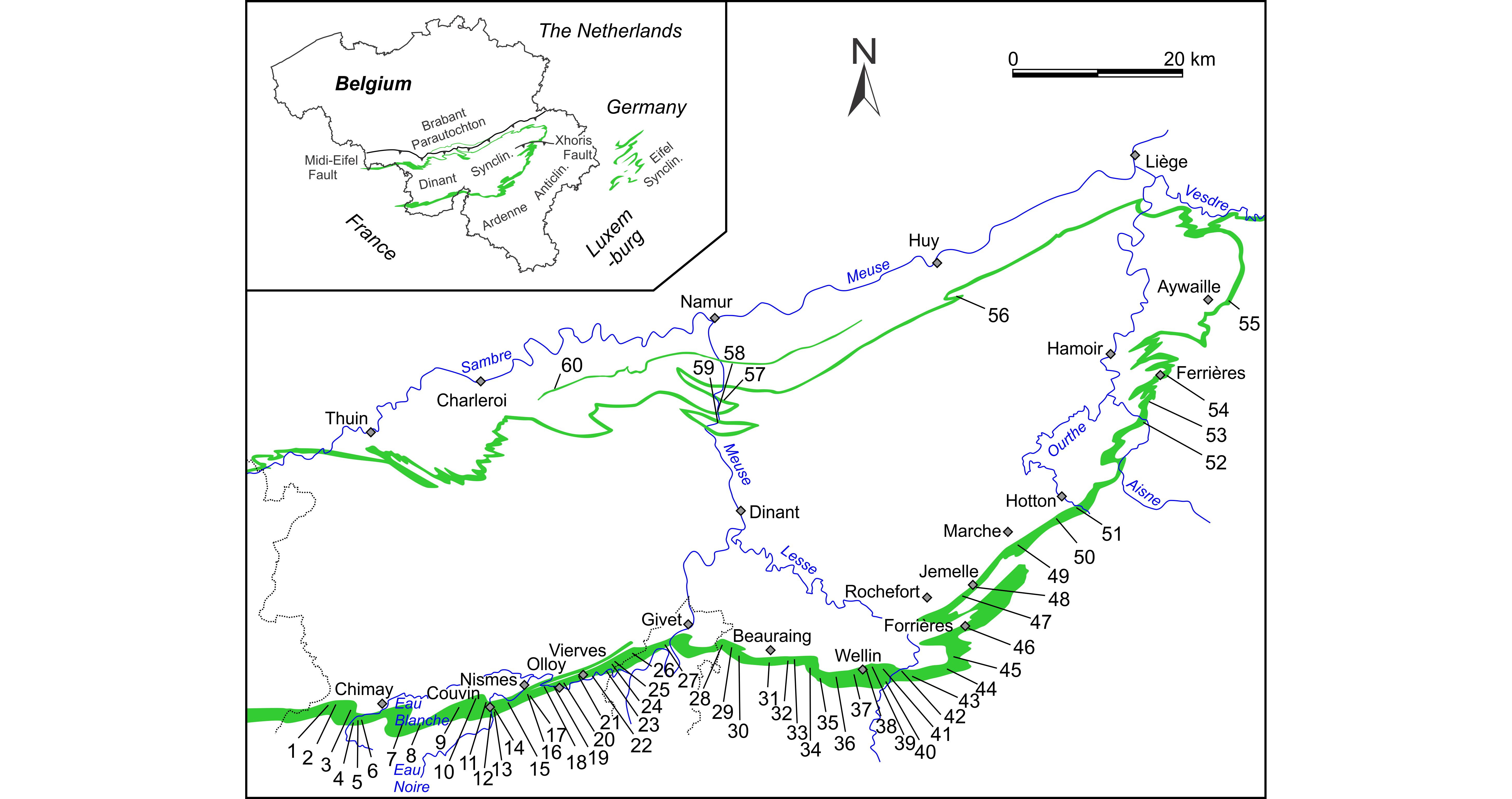
Figure 1. Simplified geological map of southern Belgium and surrounding area with the Eifelian strata in green. Numbers refer to the localities described in the text and detailed in Appendix 1. Macon Tivoli, 2. Salles, 3. Villers-la-Tour, 4. Villers-la-Tour railway, 5. Villers-la-Tour quarry, 6. Saint-Remy, 7. Bourlers, 8. Baileux quarry and outcrops, 9. Parrain quarry, 10. Tienne al Chapelle, 11. La Couvinoise quarry, 12. Eau Noire river, 13. Sainte-Barbe quarry, 14. Abîme cliff, 15. Petigny ‘Cul d’Efer’ and ‘rue Augile’ sections, 16. Tienne Sainte-Anne and Fondry des Chiens, 17. Roche Trouée and Saint-Joseph quarry, 18. Dourbes railway, 19. Olloy-sur-Viroin ‘La Goutelle’ and ‘Par-delà l’eau’, 20. Roche du Pas, 21. Vierves-sur-Viroin road, 22. Vierves-sur-Viroin castle, 23. Treignes, 24. Najauge, 25. Mazée, 26. Hierges-Vaucelles road, 27. Foisches, 28. Dion W ‘Les Vérennes’, 29. Dion S ‘Prêle’, 30. Javingue, 31. Wancennes, 32. Pondrôme ‘le Tilleul’, 33. Eclaye and Pondrôme railway, 34. Pondrôme ‘les Rochettes’, 35. Sohier, 36. Froidlieu, 37. Wellin ‘Tienne de Reumont’ and ‘Les Marlières’, 38. Fond-des-Vaux, 39. Coputienne, 40. Halma, 41. Croix Jeumont, 42. Resteigne quarry, 43. Resteigne South, 44. Grupont, 45. Lesterny, 46. Forrières, 47. Jemelle railway, 48. Jemelle station, 49. Waha, 50. Mesnil-Favay quarry, 51. Hampteau quarry, 52. Aisne creek, 53. Izier ‘Pont-le-Prêtre’ and ‘Boulac’ sections, 54. Ferrières vicinal, 55. Remouchamps railway, 56. Marchin, 57. Tailfer, 58. Rivière, 59. Tantachau, 60. Aisemont. Legend: Anticlin.: Anticlinorium, Synclin.: Synclinorium.
4This paper proposes a revised lithostratigraphy based on recent field recognition and mapping along the southern and eastern margins of the Dinant Synclinorium. Though the stratigraphic relationships of some formations are yet unresolved, a new scheme based on facies and supported by biostratigraphy and faunal association is proposed. The second goal is to describe the geometrical and stratigraphic relationships of these lithostratigraphic units in the reconstruction of the basin during the Eifelian time, with a peculiar focus on the reef development. Finally, a sequence stratigraphic model is introduced.
2. Geological settings
5Southern Belgium is part of the Rhenohercynian Fold Belt, which extends across Europe from Southern Portugal through southern England, northern France, Belgium, and Germany, into Poland, and resulting from the Variscan deformation that took place during the Late Carboniferous. During the Devonian, the Namur-Dinant Basin (NDB) was situated along the southeastern margin of Laurussia on the Rheno-Hercynian Ocean at an estimated latitude of 25°S (Stampfli et al., 2013; Eckelmann et al., 2014). The NDB recorded proximal facies in its northern part whereas its southern part acted as a shallow basin with more distal facies. However, deep-water environments are not known in Belgium and only suspected by comparison with the neighbouring British and German basins (Paproth et al., 1983). As part of a large carbonate shelf fringing the Laurusian continent (Fig. 1), the NDB passes eastwards to the Eifel area with which the succession shares many characters (Lecompte, 1970; Bultynck, 1970; Struve, 1982a).
6The Middle Devonian Period is characterised, in southern Belgium by the onset of the ‘carbonate factory’ – in fact starting in the late Emsian – following the deposition of the Lower Devonian siliciclastics. It was also a time marked by the onset of reef development having its acme during the Givetian (Lecompte, 1960, Flügel & Kiessling, 2002). The Middle Devonian succession is exposed in various tectonic units but the Eifelian is mostly restricted to the Dinant Synclinorium, the Haine-Sambre-Meuse overturned thrust sheets (former ‘southern limb of the Namur Synclinorium), and the Vesdre area (Fig. 1). Sedimentary interpretations of the Eifelian deposits (Bertrand et al., 1993; Préat et al., 2007; Mabille & Boulvain, 2007) diverge on the deposition settings – ramp or platform. It is most probable that a ramp developed in the late Emsian-early Eifelian locally (Chimay-Couvin) later evolved into a platform. A general model covering the whole NDB is however lacking.
7Correlations with the Middle Devonian deposits of the Eifel type area have been presented based on biostratigraphy (see Bultynck, 1970; Meyer et al., 1977; Loboziak et al., 1990; Godefroid, 1995). No correlation based on lithostratigraphy and sequence stratigraphy has been proposed so far.
3. Revised lithostratigraphy
3.1. Saint-Joseph and Eau Noire formations
8These two units erected into Saint Joseph and Eau Noire formations by Bultynck et al. (1991) were previously used as members of the ‘Assise de Bure’ (e.g. Bultynck, 1970). In their type area, near Couvin, they can be lithologically separated but eastwards, their lithological composition changes and they are hardly recognisable as separate units. On recent geological maps, they are mapped as a single unit. Moreover, their lower and upper boundaries differ from area to area. On the geological map Chimay – Couvin (Barchy & Marion, 1999) the composition and boundaries correspond to those of the stratotypes located on a path south of the Saint-Joseph village south of Nismes – nowadays completely erased – and along the Eau Noire river in Couvin respectively. On the neighbouring map Olloy-sur-Viroin – Treignes, a c. 25 m-thick unit that corresponds to the lateral equivalent of the base of the Couvin Fm was included in Saint-Joseph – Eau Noire group by Dumoulin & Coen (2008) because of the lithological similarities (see 3.2.1. and Fig. 2). Eastwards (maps Sautour – Surice by Dumoulin & Marion (1998) and Agimont – Beauraing by Lemonne & Dumoulin (1999)), the siliciclastic unit lately identified as the Vieux Moulin Member (Mbr) (Dumoulin & Blockmans, 2008; see 3.4.4) was mapped indistinctly with the Eau Noire Fm whereas the lower sandy part of the Saint-Joseph Fm was mapped as the Hierges Fm (Fig. 2). On the maps Felenne – Vencimont (Dumoulin & Blockmans, 2013a) and Pondrôme – Wellin (Dumoulin & Blockmans, 2013b), the lower limit of the Saint-Joseph – Eau Noire group follows the stratotypic definition but its upper limit still falls at the top of the carbonate unit corresponding to the lower part of the Couvin Fm. Both formations reach a maximum thickness of c. 150 m in the Wellin area (Godefroid, 1968) then thin eastwards (c. 50 m in Jemelle; Godefroid, 1968). Their composition changes eastwards, with the progressive disappearance of the carbonate part in the Eau Noire Fm east of the Ourthe valley (Lessuise et al., 1979). In the Aisne valley their facies are not distinguishable as the sandy facies dominates (Bultynck et al., 1991).
9The lithological composition of the Saint-Joseph and Eau Noire formations is not detailed here. Details can be found in Godefroid (1968), Bultynck (1970), Lessuise et al. (1979) and Bultynck et al. (1991, 2000).
10Age: In the old Belgian literature, the Saint-Joseph and Eau Noire formations are traditionally referred to ‘Co1a-c’, i.e. lower Couvinian. However, as explained above, the limestone unit ‘Co2a’ has often been included in the same lithostratigraphic unit. The Emsian-Eifelian boundary (and also the Early-Middle Devonian boundary), based on the first entry of the conodont Icriodus retrodepressus falls c. 5 m below the top of the Eau Noire Fm in its stratotype (Bultynck et al., 2000). Consequently, the abundant fauna of the Saint-Joseph and Eau Noire formations is late Emsian in age (patulus conodont zone; Weddige et al., 1979; Bultynck & Godefroid, 1974).
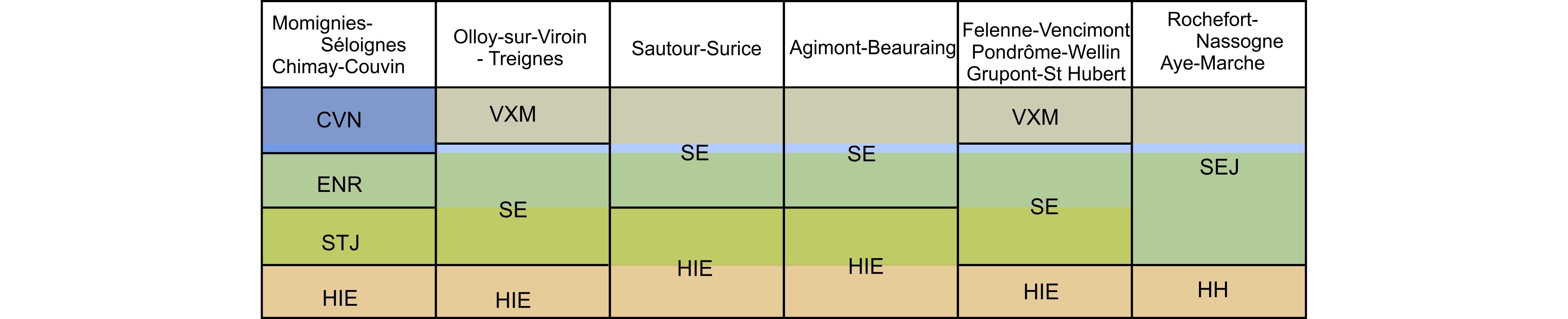
Figure 2. Relationships between the Saint-Joseph, Eau Noire, base of Couvin and Jemelle formations along the southern margin of the Dinant Synclinorium, and legend of the geological maps. After Barchy & Marion (1999, 2001), Dumoulin & Marion (1998), Lemonne & Dumoulin (1999), Dumoulin & Blockmans (2013a, 2013b). Legend: CVN: Couvin Fm, ENR: Eau Noire Fm, HH: Hierges-Hampteau Group, HIE: Hierges Fm, SE: undifferentiated Saint-Joseph & Eau Noire formations, SEJ : undifferentiated Saint-Joseph, Eau Noire and Jemelle formations, STJ : Saint-Joseph Fm, VXM : Vieux Moulin Mbr; light blue band indicates the limestone Sohier Horizon.
3.2. Couvin Formation
11The traditional view of the Couvin Fm is almost entirely based of the stratotype section along the Eau Noire river for the lower part and in the Abîme cliff for the upper part, both in the town of Couvin (Lecompte, 1960; Tsien, 1969; Bultynck, 1970). Only three other sections exposing discontinuously the Couvin Fm received attention: the Villers-la-Tour and Saint Remy quarries west of Chimay (Bertrand et al., 1993) and the Saint-Joseph quarry near Nismes (Bultynck et al., 1991). The most detailed description of the stratotypic succession can be found in Bultynck (1970). However, several other sections exposing various units are crucial for the interpretation of the formation and its lateral evolution (see Appendix 1). These sections are here described.
12The observation of these sections led to reconsider the composition of the Couvin Fm, especially to consider that the stratotype is not entirely representative of the formation and does not expose all facies. In the type sections, Bultynck (1970) described four lithological units in the Couvin Fm (Fig. 3): the ‘first biostrome’ (unit 1, sub-units i-k in Bultynck, 1970); the ‘first subsidence period’ (unit 2, sub-unit l); the ‘second biostrome’ (unit 3, sub-units m-q); and then the ‘third biostrome’ (unit 4, sub-units r-z). Bultynck et al. (1991) introduced two members: the Foulerie Mbr including units 1-3 and the Abîme Mbr for the last unit (except sub-unit r still in the Foulerie Mbr). The Foulerie Mbr groups three very distinct lithological assemblages that can be easily distinguished in the field. Hence it is proposed to replace the unsuitable Foulerie Mbr by three lithologically well constrained members corresponding to Bultynck’s (1970) lower three units of the ‘Calcaire de Couvin’ as suggested by Bultynck & Godefroid (1974). The Abîme Mbr is preserved without change even if lithological variations are detected.
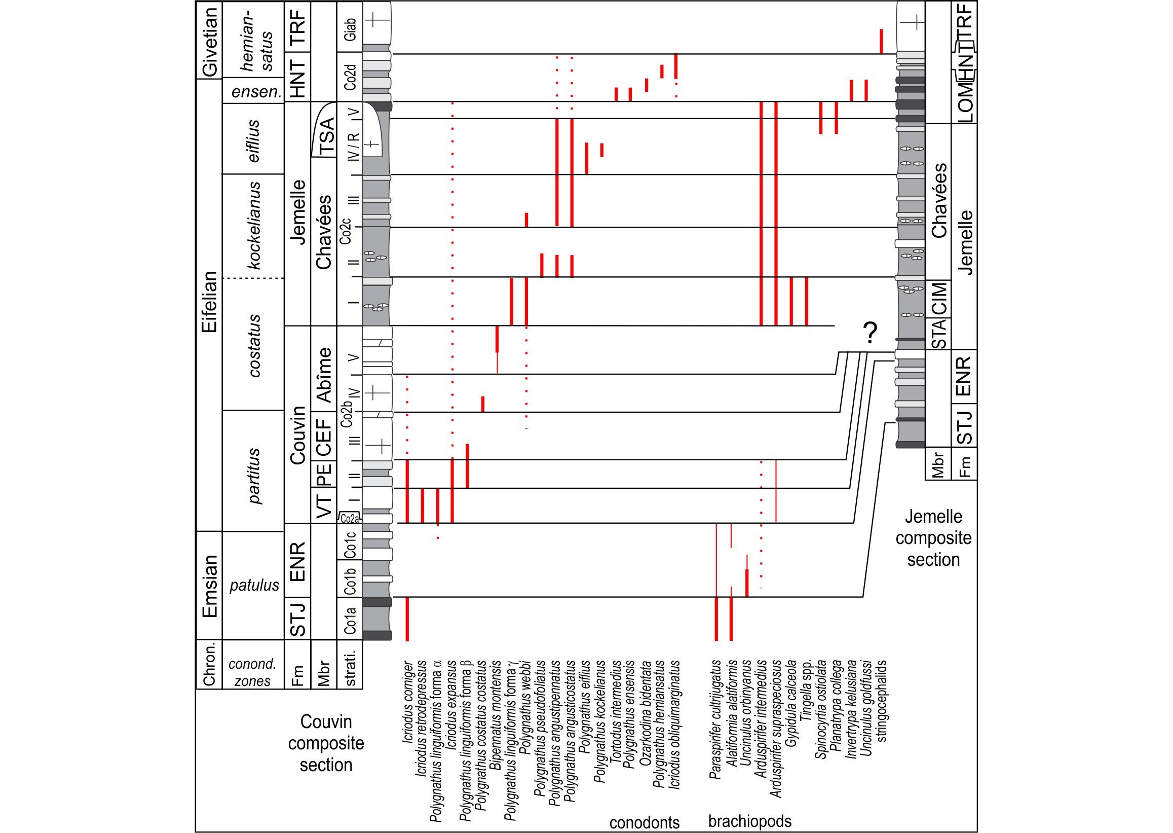
Figure 3. Comparison of the Eifelian succession in the Couvin and Jemelle areas after Godefroid (1968) and Bultynck (1970) with stratigraphic occurrences of selected guide taxa among conodonts, and brachiopods. Legend: chron.: chronostratigraphy (after Belka et al., 1997), Fm: formation, Mbr: member, strati.: bio-litho-stratigraphic units of Bultynck (1970); CEF: Cul d’Efer Mbr, CIM: Cimetière Mbr, ENR: Eau Noire Fm, HNT: Hanonet Fm, LOM: Lomme Fm, PE: Petigny Mbr, STA: Station Mbr, STJ: Saint-Joseph Fm, TRF: Trois-Fontaines Fm, TSA: Tienne Sainte-Anne Mbr, VT: Villers-la-Tour Mbr. Solide bold lines: diagnostic stratigraphic distribution, thin lines: maximal extension, dotted lines: sporadic occurrences.
3.2.1. Villers-la-Tour Member
13Synonyms: Unit 1, ‘first biostrome’ in Bultynck (1970), Member I in Bultynck & Godefroid (1974).
14Key sections: The stratotype of the member is situated along the disused railway SE of Villers-la-Tour, 3 km SW of Chimay (Fig. 1). The lower 10 m are poorly exposed but can be easily observed in the Eau Noire section in Couvin. The Sainte-Barbe disused quarry also exposes the member but the weathering of the rock does not allow proper observations anymore.
15Description: The base of the Couvin Formation is defined above the last thick shaly bed included in the Eau Noire Fm (Bultynck et al., 1991) and starts with a first unit of finely bioclastic and crinoidal packstone, usually blueish and slightly argillaceous with some thin shaly interbeds. This first unit (sub-unit i of Bultynck, 1970) is commonly poor in fauna, except some stromatoporoids and lamellar tabulate corals in its upper part. Bultynck (1970) reports a thickness of 13 m. Above this basal unit there is a first biostromal unit (sub-unit j) c. 22-25 m-thick, roughly stratified, with large lamellar stromatoporoids and tabulate corals (mostly Alveolites) encrusting a coarse-grained crinoidal rudstone. The rugose corals (Sociophyllum, Mesophyllum) are also present as broken fragments. The biostrome is mainly an autobiostrome with in situ elements in the lower part but evolves upsection into a parabiostrome with reworked and broken stromatoporoids randomly accumulated, e.g. in the Sainte-Barbe quarry where Tsien (1971) considered the accumulation as a large bioherm. In the Villers-la-Tour railway section, the biostrome (Fig. 4A) is well exposed and displays a cyclic pattern with large stromatoporoids and corals (Heliolites, Alveolites, Sociophyllum) at the base and fining-upwards with crinoidal and bioclastic limestone. In the Eau Noire section, Bultynck (1970) distinguished a 4 m-thick unit (k) without stromatoporoid above the biostrome but it appears that it is more probably the upper part of a larger cycle as exposed in Villers-la-Tour.
16Age: Bultynck (1970) indicates in these beds the occurrence of the conodonts Icriodus retrodepressus and I. expansus indicating the lower part of partitus conodont zone (Fig. 3).
17Remark: East of Nismes, the Villers-la-Tour Mbr disappears but its basal carbonate unit remains between the Eau Noire Fm and Vieux Moulin Mbr. This 10–20 m-thick unit of argillaceous limestone, often crinoidal but poor in macrofauna can be traced up to the Jemelle area. The new term Sohier Horizon is proposed for this unit corresponding to the lithological sub-unit i of Bultynck (1970). Good exposures of this carbonate unit are situated in the embankment of the road between Sohier and Froidlieu and in adjacent disused quarries (see Appendix 1). The Jemelle, Resteigne and Chanly sections (see sections n°1, H.7, Ch.15 and R.2 in Godefroid, 1968) also expose this horizon. Eastwards, the carbonate content decreases consequently and both formations are hardly distinguishable from the overlying Jemelle Fm. Note that the Sohier Horizon was mapped together with the Eau Noire Fm between Nismes and Jemelle (Dumoulin & Blockmans, 2008). In Halma section H.7 (Godefroid, 1968), the limestone horizon yielded the conodonts Icriodus corniger, I. retrodepressus, I. expansus and Polygnathus linguiformis forma α, whereas in Grupont (Godefroid, 1968), it yielded P. costatus partitus and I. retrodepressus (Bultynck & Godefroid, 1974), indicating the lower partitus zone, i.e. the age of the Villers-la-Tour Mbr.
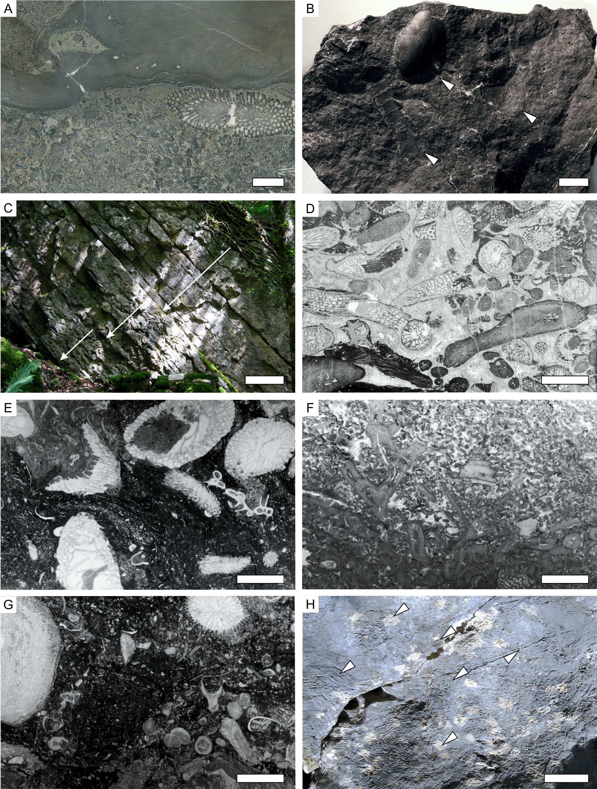
Figure 4. Illustration of some macro- and micro-facies of the Couvin Fm. A. stromatoporoids and tabulate corals in the ‘first biostrome’ (Villers-la-Tour Mbr) in the Villers-la-Tour disused railway section (polished slab VTRI/18); B. dark fine-grained facies with pelecypod and cephalopods (arrows) of the Petigny Mbr (sample CEIII/A); C. cyclic parabiostromes (arrows) in the Cul d’Efer Mbr, Cul d’Efer section in reverse position; D. bioclastic rudstone with amphiporids and Dendrostella typical of the Abîme Mbr (RCC/3); E. dark argillaceous packstone with rugose and tabulate corals typical of the Saint-Remy Facies of the Abîme Mbr, Saint-Remy quarry (CSR/10); F. crinoidal and bioclastic grainstone to rudstone in the Abîme Mbr, Villers-la-Tour quarry (VTCII/5); G. argillaceous bioclastic packstone of the Vierves Mbr in Vierves-sur-Viroin section (VVID/16); H. macroscopic view of the biohermal facies with large colonies and stromatoporoids in the Abîme Mbr, Roche Trouée in Nismes, arrows indicates coral colonies and stromatoporoids. Scale bars equal 10 mm for all but 50 cm for C and 10 cm for H.
3.2.2. Petigny Member
18Synonyms: Unit 2, ‘first subsidence period’ in Bultynck (1970), Member II in Bultynck & Godefroid (1974).
19Key sections: The stratotype is defined in small disused quarries along the Augile Street, south of Petigny, 1.5 km E of Couvin (Fig. 1). In the Eau Noire section in Couvin, the member is discontinuously exposed.
20Description: In the Eau Noire section, the coarse bioclastic rudstone with stromatoporoids of the Villers-la-Tour Mbr is covered by a c. 40 m-thick unit of dark grey or blueish-grey argillaceous limestone alternating with some shaly beds. The bioclastic content is poor and limited to small crinoids, bryozoans and brachiopods fragments in a matrix containing up to 25% of clay and silt in the lower part (Bultynck, 1970). In Petigny, this unit is a dark argillaceous limestone with some fine-grained bioclastic layers and a peculiar fauna of large bivalves that seem to be in situ in the sediment (Fig. 4B). Rare brachiopods, ostracods, solitary corals and orthocerids are the other components. In its stratotype, the Petigny Mbr is c. 50 m-thick, the upper half being darker. This unit was very locally quarried as the ‘Marbre noir de Couvin’ in the 19th century (Kaisin, 1935 reporting Maillieux’s comment).
21Age: Icriodus nodosus and I. corniger are reported by Bultynck (1970) from Eau Noire section. The member is included in the partitus conodont zone (Fig. 3).
3.2.3. Cul d’Efer Member
22Synonyms: Unit 3, ‘second biostrome’ in Bultynck (1970), Member III in Bultynck & Godefroid (1974).
23Key sections: The Cul d’Efer sections are open-sky cryptokarstic cavities that were mined for iron hydroxides (Fonderie Jean Cosse) in the woody hill west of Petigny (Fig. 1). The boundary with the underlying member is exposed immediately south of the Cul d’Efer section II (west) whereas the boundary with the overlying member is exposed in the Cul d’Efer section I (east).
24Description: This unit is poorly exposed along the Eau Noire section and Bultynck (1970) gave only a superficial description of the lower part. The Cul d’Efer sections however expose in good conditions the ‘second biostrome’ that displays two phases. The first is a c. 25 m-thick unit of lamellar alveolitid autobiostrome alternating with and covering crinoidal rudstone. The tabulate corals and stromatoporoids are mostly in life position. The second part dominantly comprises cyclic deposits. Each cycle starts with coarse bioclastic rudstone passing to large bulbous stromatoporoids (up to 50 cm in diameter), Heliolites and large solitary rugose corals (Mesophyllum, up to 40 cm-long). These accumulations form parabiostromes where elements are not in living position. The parabiostromes pass upwards to finer grained bioclastic grainstone-packstone then to darker wackestone with abundant amphiporids, small tabulate coral branches (including Syringocystis and Hillaepora) and common Cystiphylloides spp. Some shaly interbeds with limestone or dolostone lenses are often developed. The cycles vary in thickness from 2 m up to 9 m but the composition is relatively constant and varies only in granulometry and proportion of matrix (Fig. 4C). Five or six such alternations can be seen in the Cul d’Efer section I and six in Cul d’Efer section II. Only one is exposed along the Eau Noire section. These alternations possibly correspond to relative sea-level oscillation-related parasequences as some of them show a clear shallowing-upwards trend. The reworked aspect of the fauna also suggests a deposition under high hydrodynamic settings. The upper part of ‘second biostrome’ (sub-units o-p) is dolomitised in the Eau Noire section and Cul d’Efer section I (Fig. 3).
25Age: The Cul d’Efer Mbr yielded few conodonts in the Eau Noire section (Bultynck, 1970), including Icriodus expansus, I. nodosus, I. corniger and Polygnathus webbi, suggesting still the partitus zone.
3.2.4. Abîme Member
26Synonyms: Unit 4, ‘third biostrome’ in Bultynck (1970), Member IV-V in Bultynck & Godefroid (1974).
27Key sections: Eau Noire and Abîme sections in Couvin, Cul d’Efer section I, Parrain quarry NW of Couvin, Villers-la-Tour quarry, Saint-Remy quarry in Chimay, Saint-Joseph quarry in Nismes (Fig. 1 and Appendix 1).
28Description: Bultynck (1970) indicates that an exposure gap between the ‘second’ and ‘third biostrome’ might correspond to more shaly facies that are not cropping out in the Eau Noire section – shaly facies that he would have expected as a ‘second subsidence period’. However there is no trace of such facies in any section. The ‘third biostrome’ starts in the stratotype by massive beds rich in stromatoporoids and tabulate corals (sub-unit r) forming parabiostromes with an abundant packstone matrix, often slightly dolomitic. An interval of dark argillaceous limestone c. 4–6 m-thick can be recognised in the Eau Noire section (sub-unit s) and in the Villers-la-Tour, Saint-Remy and Saint-Joseph quarries (Fig. 4E). The facies is darker but the fauna is abundant and includes thin laminae of stromatoporoids and massive tabulate corals, solitary rugose corals, brachiopods, ostracods and well-preserved trilobites. There is consequently no clue for dysoxic conditions. In the Chimay and Villers-la-Tour area, these dark facies are thicker (at least 10 m exposed in the Saint-Remy quarry) and rich in fauna. We refer to this dark argillaceous limestone as the Saint-Remy Facies. Above this dark bed, the development of cyclic biostrome starts again in the Couvin area (e.g. in the Abîme Cliff section). Stromatoporoid biostromes alternate with accumulations of broken branches of corals (small ramose tabulates and thinly branched Dendrostella and Fasciphyllum, Fig. 4D) and amphiporids (sub-units v-x in Bultynck, 1970). Again these 1 to 5 m-thick cyclic deposits are interpreted as parasequences. Some of them are capped by mud-cracks as already noticed by Lecompte (1960) witnessing their final emersion. These facies seem to disappear westwards as they are replaced by massive accumulations of coarse bioclastic grainstone-rudstone with stromatoporoids and corals in the Villers-la-Tour quarry (Fig. 4F).
29Eastwards the ‘third biostrome’ and associated facies are the only remnants of the Abîme Mbr. In the Roche Trouée (Nismes), a similar succession is known, starting with a 15 m-thick unit of thinly-bedded bioclastic packstone-grainstone with rare tabulate corals possibly corresponding to the sub-unit v of the type section. A biostrome c. 5 m-thick mainly built by lamellar stromatoporoids and tabulate corals is developed on crinoidal rudstone and acts as a basis for a small bioherm c. 50 m in diameter and 20 m in height. This bioherm exposed in the Roche Trouée site (Fig. 1) is very rich in bulbous stromatoporoids, large colonies of dendroid rugose corals (Fasciphyllum, Sociophyllum, Fig. 4H) and ramose tabulate corals. The bioclastic matrix is locally abundant. The bioherm passes laterally to bioclastic rudstone beds still rich in corals and stromatoporoids. On top of the bioherm there is a badly stratified bioclastic limestone unit containing layered accumulations of small branches of tabulate corals and amphiporids. These facies are obviously the equivalents of the sub-unit x of the Eau Noire section. As in this section, fine-grained wackestone-packstone with occasional colonies of corals and numerous brachiopods occurs at the top of the Abîme Mbr. The boundary with the Jemelle Fm is not exposed but falls in a c. 10 m-large exposure hiatus along the norther edge of the Roche Trouée hill, and close to the northern wall of the Villers-la-Tour quarry.
30Age: The most significant conodonts of the Abîme Mbr are Bipennatus montensis (identified as Spathognathodus cf. bipennatus by Bultynck, 1970; see Narkiewicz, 2015) and Polygnathus costatus costatus indicating the costatus zone. P. costatus costatus was however found slightly below the base of the Abîme Mbr in the Eau Noire section (Bultynck & Godefroid, 1974) (Fig. 3).
3.2.5. Vierves Member
31Key sections: Autre côté de l’Eau Street, La Goulette and Roche du Pas sections in Olloy-sur-Viroin, Vierves-sur-Viroin road section, Mazée and Foisches sections. East of the Meuse valley, there are good exposures in Eclaye and Les Rochettes in Pondrôme, Froidlieu and Tienne de Reumont near Wellin (Fig. 1 and Appendix 1).
32Description: The Abîme Mbr that corresponds roughly to the ‘third biostrome’ is 160 m-thick in the type section in Couvin and in Petigny Cul d’Efer sections. Eastwards, in the Roche Trouée, only the 100 upper metres are still present (see 3.2.4 and Fig. 5). In Olloy-sur-Viroin i.e. 3.5 km east of the Roche Trouée, the thickness of the bioclastic and argillaceous limestone corresponding to the remnant of the Abîme Mbr is less than 20 m-thick in the ‘Goulette’ section. In the Roche du Pas, c. 1 km eastwards, the only trace of the member are a 3 m-thick biostrome with stromatoporoids and Heliolites overlaid by 3-4 m of bioclastic packstone. In Vierves-sur-Viroin, i.e. 5 km east of the Roche Trouée, the succession comprises only 50 m of argillaceous limestone with numerous corals (mostly solitary rugose corals and massive tabulates) and brachiopods but almost devoid of stromatoporoids, suggesting deeper settings and/or an increased influx of fine siliciclastics (Fig. 4G). Limestone with stromatoporoids re-appears east of Vierves-sur-Viroin as small biostrome in the Vierves mine section and in Mazée. In the Foisches section, south of Givet, c. 20 km eastwards, the equivalent is composed of argillaceous and silty limestone with brachiopods (Lemonne & Dumoulin, 1999).
33In the Vierves-sur-Viroin road section, the composition of the unit can be detailed (Fig. 6). The top of the Vieux Moulin Mbr is made of fossiliferous, slightly calcareous siltstone with nodules of finely bioclastic dark limestone. The base of the Vierves Mbr is defined by the first laterally-continuous bed of bioclastic limestone (mudstone to wackestone). Shaly and silty interbeds are 1 to 10 cm-thick and often contain calcareous nodules (unit A in Fig. 6). Fossils are abundant in the lower part (bryozoans, brachiopods, trilobites, ostracods), solitary rugose corals appear in the lower third whereas lamellar tabulate corals become abundant in the upper third of this 4 m-thick unit A. Upwards the argillaceous content of the limestone (bioclastic wackestone to floatstone) decreases and the shaly interbeds become rarer (unit B). An abundant fauna is present, mainly solitary rugose corals (Cystiphylloides, Mesophyllum, Acanthophyllum) but also in situ colonies of Thamnophyllum and fragments of Fasciphyllum and Disphyllum. Heliolites and alveolitids forming large colonies are also present. Stromatoporoids, though present as small domal colonies or isolated laminae, are not common. This second unit is c. 30 m-thick. The upper part of the member (unit C, 15 m) is more thickly-bedded and carbonate but argillaceous layers are not uncommon. The boundary with the overlying Chavées Mbr of the Jemelle Fm is not clear-cut as the latter starts typically with an alternation of 30-40 cm-thick beds of fossiliferous argillaceous limestone and 10-30 cm-thick interbeds of blueish bioclastic shale. However, the top of the Vierves Mbr — a 60 cm-thick bed of slightly dolomitic greyish grainstone with tabulate corals — is overlaid by a 20 cm-thick bed of argillaceous dark limestone with abundant brachiopods defining the base of the Chavées Mbr (Fig. 6). The first shale bed appears above this limestone. Fossils are very abundant in the basal 20 m of the Chavées Mbr: brachiopods (including very abundant gypidulids), Cystiphylloides, Calceola, trilobites, bryozoans. This rich association is typical of the base of the Chavées Mbr in this area. Non calcareous shale with brachiopods and bryozoans starts above.
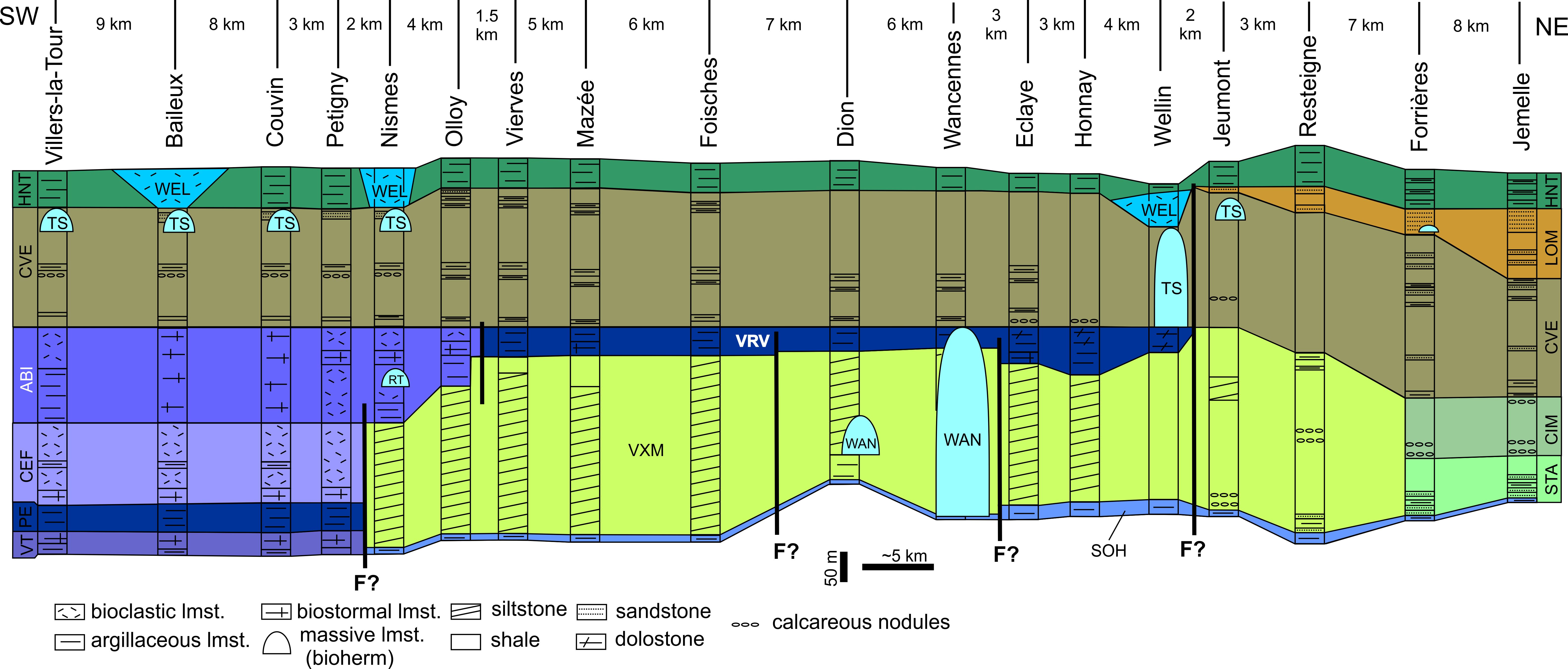
Figure 5. Schematic transect along the southern margin of the Dinant Synclinorium, showing the lateral variation in the Eifelian lithostratigraphic succession between Villers-la-Tour and Jemelle. Legend: ABI: Abîme Mbr (Couvin Fm), CEF: Cul d’Efer Mbr (Couvin Fm), CIM: Cimetière Mbr (Jemelle Fm), CVE: Chavées Mbr (Jemelle Fm), HNT: Hanonet Fm, LOM: Lomme Fm, PE: Petigny Mbr (Couvin Fm), RT: Roche Trouée biohermal facies, SOH: Sohier Horizon (Jemelle Fm), STA: Station Mbr (Jemelle Fm), TS: Tienne Sainte-Anne Mbr (Jemelle Fm), VRV: Vierves Mbr (Couvin Fm), VT: Villers-la-Tour Mbr (Couvin Fm), VXM: Vieux Moulin Mbr (Jemelle Fm): WAN: Wancennes Fm, WEL: Wellin Mbr (Hanonet Fm); F?: putative synsedimentary fault. Modified from Dumoulin & Blockmans (2008) with additions from Bultynck (1970), Godefroid (1968), Coen-Aubert et al. (1991) and new observations.
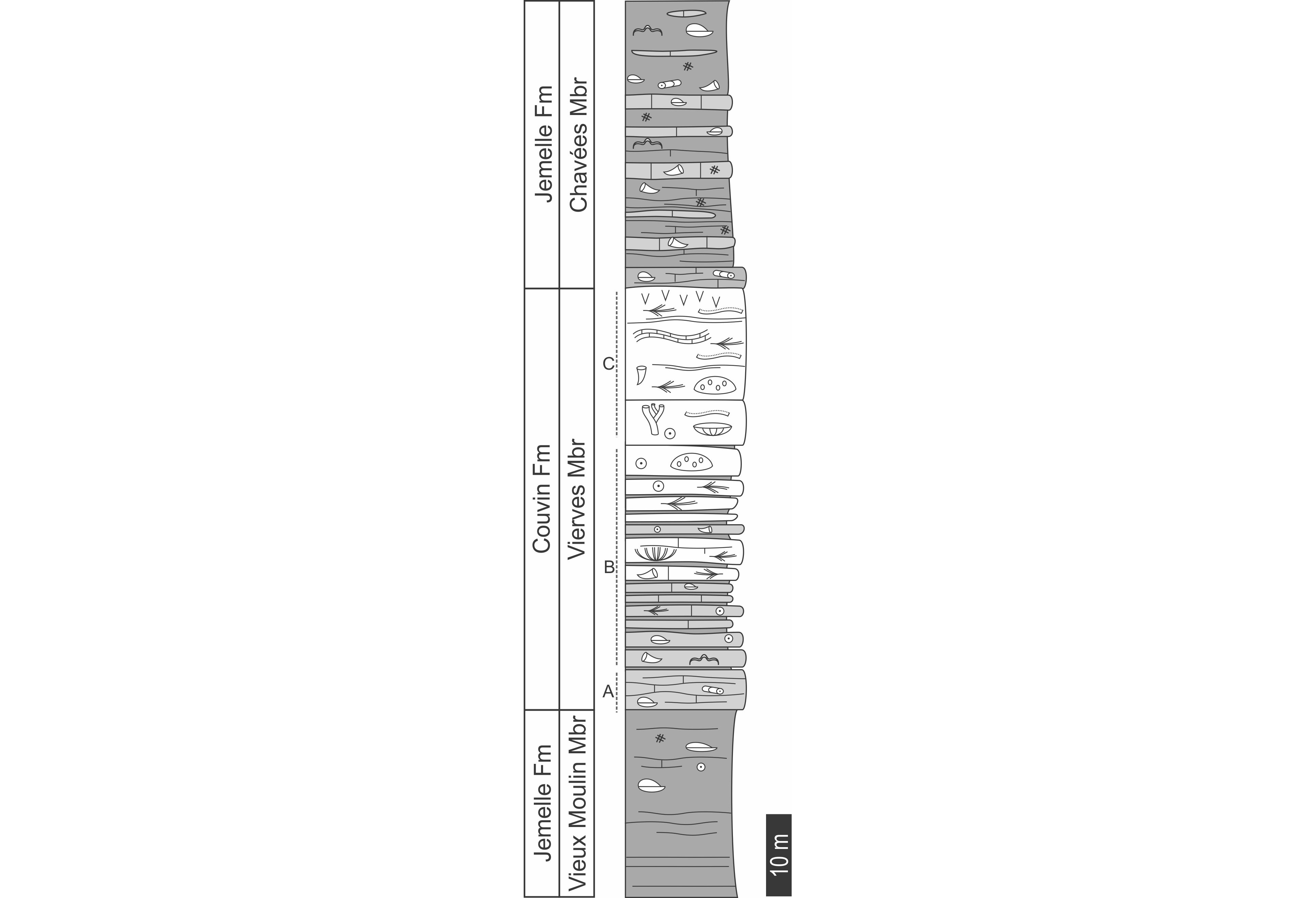
Figure 6. Schematic log of the Vierves Mbr of the Couvin Fm in its stratotype. Legend: see Fig. 9.
34In summary, the Vierves Mbr is dominantly composed of argillaceous bioclastic limestone with shaly interbeds, the latter being less abundant in the upper part. A thickness of 50 m is estimated, with a base defined by the first continuous bed of limestone above the silty Vieux Moulin Mbr; and the top defined by the first argillaceous limestone capping the last thick bed of coarse-grained and dolomitic limestone below the Chavées Mbr. The dark facies has many similitudes with the Saint-Remy Facies of the Abîme Mbr as developed in the Chimay and Villers-la-Tour area (compare Figs 4E and 4G).
35The Vierves Mbr can be traced between Olloy-sur-Viroin to the Meuse valley and eastwards to Pondrôme and Wellin where the argillaceous dark limestone facies is well developed (e.g. outcrops in Dion, Javingue, Honnay, Fig. 1). Local accumulation of stromatoporoids and corals indicates the development of laterally limited reefal facies in the upper part, but rarely thicker than 15 m. Such facies are exposed in the Roche du Pas (Olloy-sur-Viroin), Vierves mine section, Mazée, Eclaye, Pondrôme and along the Tienne de Reumont ouctrops between Froidlieu and Wellin (Fig. 1). In this locality the Vierves Mbr is dolomitised, with a dolomitisation increasing eastwards both in intensity and by the thickness affected by dolomitisation. The easternmost outcrop of the Vierves Mbr is located in the Les Marlières forest, north of Wellin (Fig. 1) where it is directly overlaid by a large bioherm within the Jemelle Fm (see 3.5.4 and 3.5.5). It has to be noted that the well-bedded dolomitic limestone unit exposed in the disused quarry of the Fond des Vaux section I of Godefroid (1968) is not an equivalent of the Couvin Fm but is younger (see discussion of age below). Maillieux (1938) indicated that the stromatoporoid limestone ‘Co2b’ can be followed up to the Wève locality near Bure (Lesse Valley) but there is no trace of the carbonate unit east of Wellin, except some nodular limestone (Godefroid, 1968).
36Age: There is very few conodont data for this member and only Dumoulin & Blockmans (2008) reported Bipennatus montensis from the top of their ‘Couvin Fm’ (i.e. Vierves Mbr) in Wellin, suggesting the exact same age as the top of the Abîme Mbr in the type section (Fig. 3). Moreover, this conodont confirms that the top of the Vierves Mbr is synchronous with the top of the Abîme Mbr, contrary to the hypothesis presented by Dumoulin et al. (2006) and Dumoulin & Blockmans (2008).
3.3. Wancennes Formation
37This new term is introduced to designate the light grey massive limestone rich in reefal organisms cropping out between Dion and Pondrôme (Fig. 5). In Wancennes, Dumoulin & Blockmans (2008) noted an abnormal thickness of the ‘Couvin Fm’ and explained that the formation shows there a similar development as in the type section of Couvin. However, neither the development nor the facies are comparable to the Couvin Formation in its stratotype. New name and definition are therefore required for this unit.
38Key sections: Section along the creek and in the crops NE of the Wacennes village, 1 km south of Beauraing (Fig. 7). Additional outcrops in Pondrôme near Le Tilleul and in the fields between Dion and Winenne (Fig. 8).
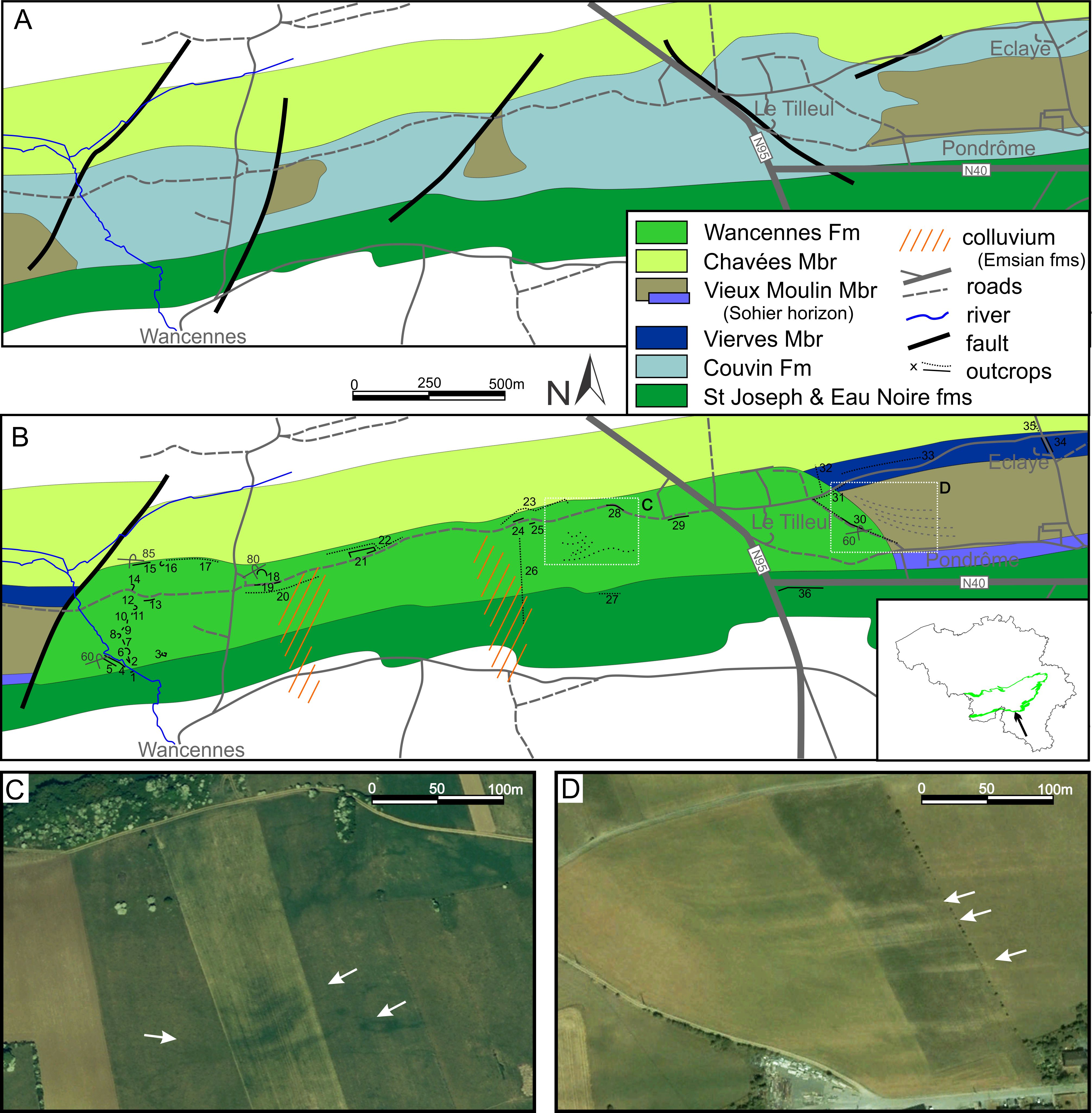
Figure 7. Geological maps of the Wancennes-Pondrôme area. A. Published geological map (Dumoulin & Blockmans, 2013a, 2013b); B. new interpretation of the same area. C. Airborne picture of squared area in B during summer drought in 2007, arrows indicate argillaceous facies in the middle part of the bioherm. D. Airborne view of squared area in B during summer drought in 2006, arrows indicate limestone beds in the Vieux Moulin Mbr abutting on the flank of the Wancennes bioherm. Numbers refers to outcrops and transects in ploughed fields in the Wancennes Fm type area (see Appendix 1). C-D modified from Google Earth©.
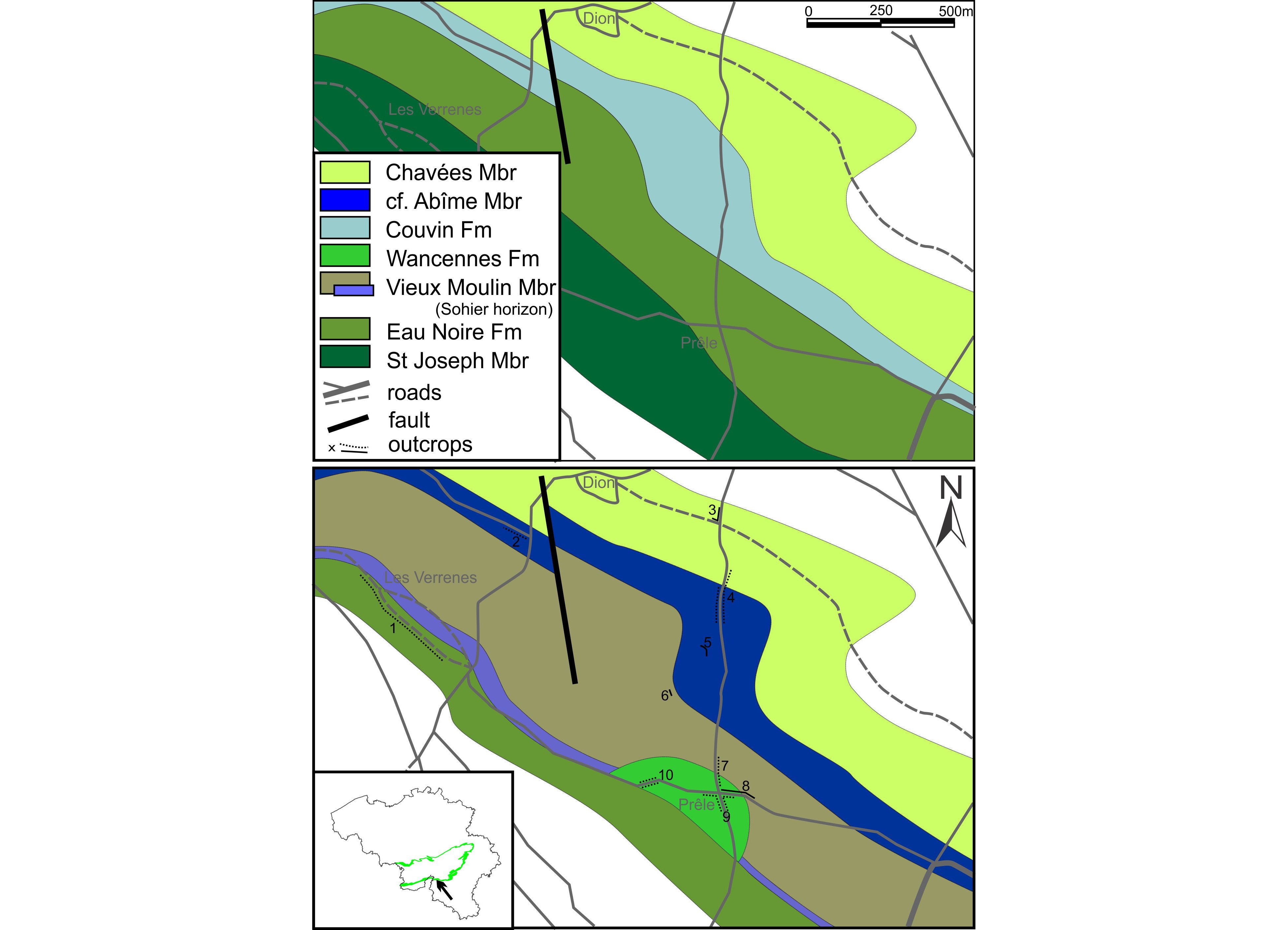
Figure 8. Geological maps of the Dion area. Comparison of the maps drawn by Dumoulin & Blockmans (2013b) and new interpretations. Numbers are outcrops and transects in ploughed fields in the area (see Appendix 1).
39Description: In the Wancennes section, the base of the reef is not exposed and a c. 5 m long exposure gap exists between the last dark grey and argillaceous crinoidal limestone of the Eau Noire Fm and the first horizons of the reef. The base of the formation is therefore defined by the first beds of light grey crinoidal rudstone covered by large lamellar stromatoporoids as badly exposed in crop furrows along the road Wancennes-Beauraing (see Fig. 7). This alternation of lamellar stromatoporoids covering thick beds of crinoidal rudstone extremely rich in brachiopods, gastropods, trilobites and tabulate corals forms a first unit c. 20 m-thick (Figs 9, 10A). A second unit 20 m-thick is similar in facies but differs by the high abundance of bulbous stromatoporoids and alveolitids. Brachiopods are also abundant in clusters within cement-filled cavities. Upwards, a 20–25 m-thick massive unit is almost entirely composed of large lamellar stromatoporoids (n°6 in Fig 9). Tabulate corals (mainly alveolitids) and fasciculate rugose corals (Fasciphyllum, Lyrielasma, Sociophyllum, Fig. 10B) first appear in the next 25 m, still with stromatoporoids (lamellar and bulbous) and light grey crinoidal rudstone. The following 15–20 m are poorly exposed but similar facies can be observed in debris. The next 80–100 m are composed of light grey massive framestone with lamellar and bulbous stromatoporoids, ramose, lamellar and dome-shaped tabulate corals (alveolitids, thamnoporids) and rugose corals (Fasciphyllum, Australophyllum, Sociophyllum). The crinoidal and bioclastic matrix is locally abundant. Cemented cavities are also common (Fig. 10C). Despite the lack of continuous section, indirect evidence — such as blocks emerging from ploughed fields and signature of clayish content in aerial photographies taken during drought (Figs 7C-D) — allows the recognition of a 10–20 m-thick unit of fine-grained, argillaceous limestone in the reef (n°26 in Fig. 9). The dominant facies is a greyish wackestone usually rich in Fasciphyllum and ramose tabulate corals suggesting a less hydrodynamic environment (Fig. 10F). The rest of the reef displays similar light grey framestone (Figs 10D-E) on 70–80 m, with an extremely diverse coral fauna, including large colonies of Xystriphyllum, cerioid colonies of Fasciphyllum (Beugniesastraea varia sensu Coen-Aubert, 1988), Sociophyllum, Dendrostella, Cyathophyllum, Taymirophyllum, very abundant Spongophyllum and the solitary Acanthophyllum, Cystiphylloides and Stringophyllum. The reef-crests, both eastwards and westwards, are dominated by large (up to 1 m in diameter) bulbous stromatoporoids associated with Heliolites colonies (n° 14-17 in Fig. 9). Local thick accumulations (up to 25 m) of whitish crinoidal rudstone with fragments of branched coral colonies obviously deposited laterally to the stromatoporoid reef crest (n° 18 and 21 in Fig. 9, Fig. 10G). The top of the reef is not exposed but it seems to be very clear-cut and overlaid by the shale of the Chavées Mbr of the Jemelle Fm as suggested by the shaly debris appearing in crops immediately above of the last limestone crest (Fig. 7B).
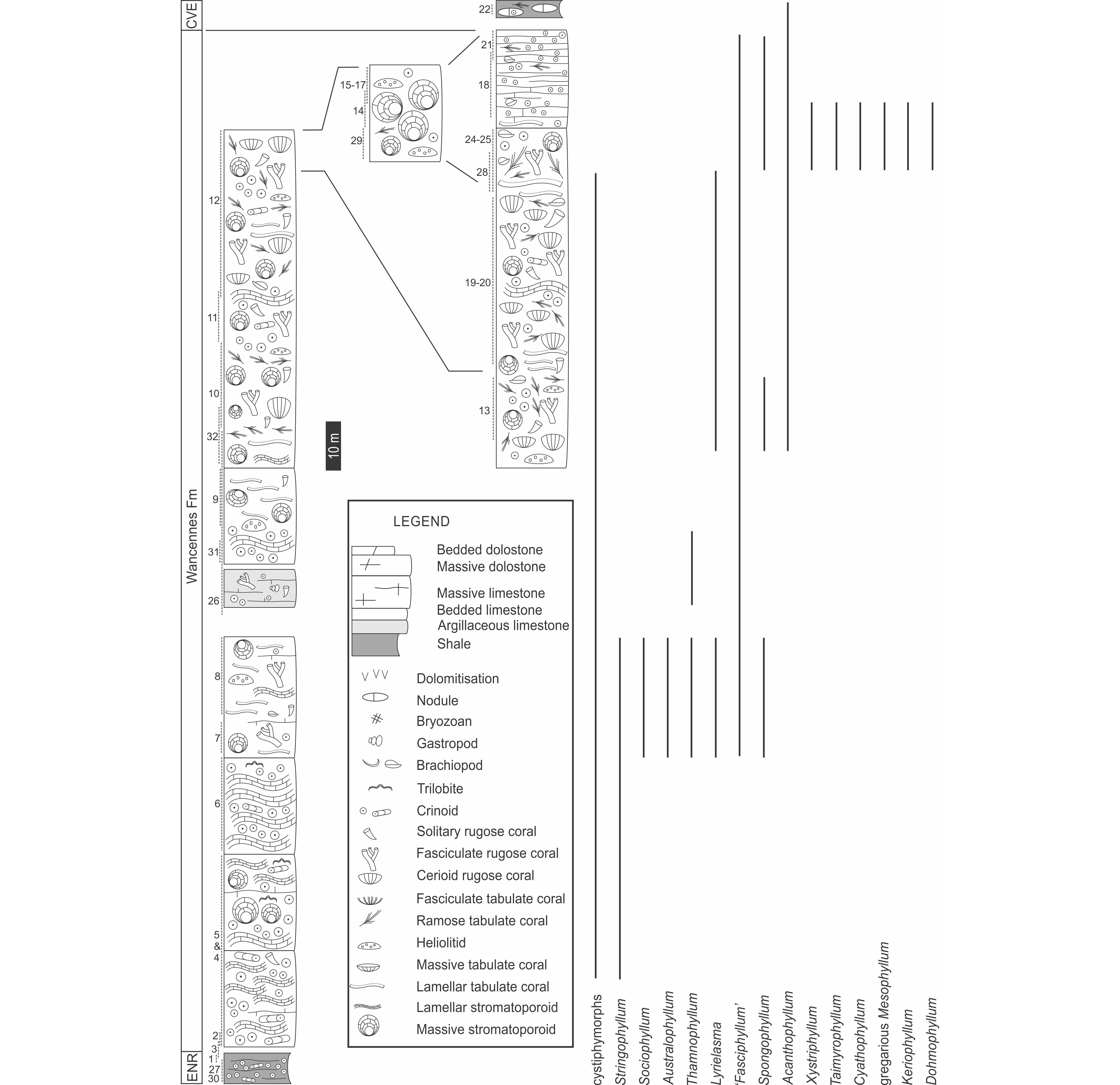
Figure 9. Schematic log of the Wancennes Fm in its stratotype with the vertical distribution of selected rugose coral genera. Note that it is a composite section made of the compilation of spot outcrops. Legend: CVE: Chavées Mbr (Jemelle Fm), ENR: Eau Noire Fm. Numbers refer to outcrops on Fig. 7 and in Appendix 1.
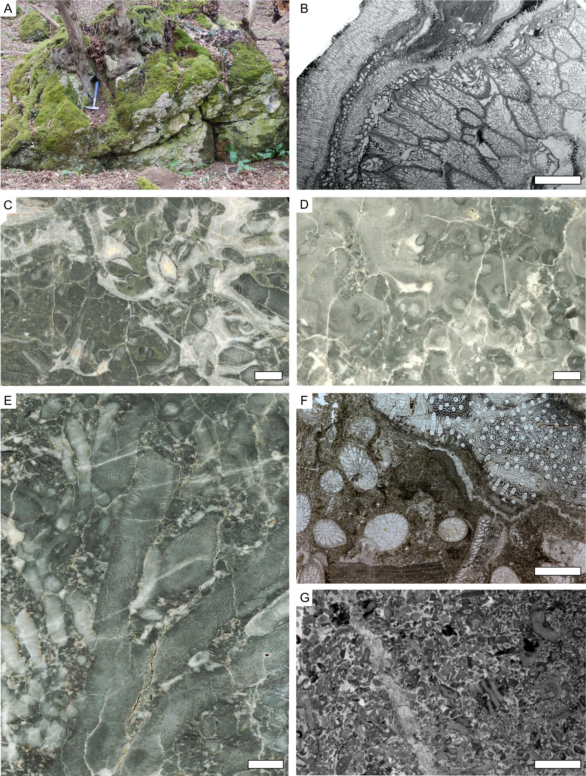
Figure 10. Illustration of some macro- and micro-facies of the Wancennes Fm. A. outcrop exposing the basal crinoidal rudstone and stromatoporoid beds of the reef (point 4 on Figs 7 and 9); B. coral framestone near the base of the reef (thin section WPEIIIC/1); C. fine-grained facies with cement-filled cavities and in situ (?) brachiopods in the lower part of the Dion reef (polished slab DiII/1); D. stromatoporoid and rugose coral framestone (polished slab, cut parallel to bedding, WNVI/2); E. tabulate and rugose coral framestone with bioclastic matrix from the reefcore (polished slab WNIV/1); F: dark argillaceous bioclastic limestone in the middle part of the reef (thin section WNVII/8); G: bioclastic and crinoidal rudstone in the upper part of the reef (WNVI/1). Scale bars equal 10 mm.
40On the geological map Felennes – Vencimont, Dumoulin & Blockmans (2013b) indicate several intercalations of siliciclastics of the Vieux Moulin Mbr within the limestone mass. However, field investigations provided evidence that the mapped siliciclastics are not contemporaneous with the reef but consist of Holocene colluvium made of debris coming from the Emsian deposits forming the hills south of the outcropping area of the limestone (Fig. 7).
41Beside the large Wancennes reef (275–300 m-thick and up to 3000 m-long), a second, smaller bioherm is exposed south of Dion (Fig. 8). This small occurrence is c. 100 m-thick and 300 m-long and displays core facies with an abundant matrix and macrofauna (brachiopods, corals, few stromatoporoids).
42Age: Up to now, no conodont data are available and recent sampling yielded only indeterminable fragments of icriodids (P. Königshof, written com., May 2019). However, the top of the reef is overlain by the Chavées Mbr and yielded an abundant coral fauna, including Fasciphyllum varium (= Beugniesastraea varia sensu Coen-Aubert, 1988) which is only known in the upper part of the Abîme and Vierves members in the Couvin area (Coen-Aubert, 1988 and new data).
3.4. Jemelle Formation
43The Jemelle Fm is a complex, thick and diachronic unit dominantly siliciclastic that reaches a maximum development between Wellin and Hotton (Fig. 1). Eastwards, its thickness and marine character decrease towards the Hamoir area (Van Tuijn, 1927; Asselberghs, 1952; Lessuise et al., 1979). In the Jemelle stratotype section, the formation was divided into three members, which are in ascending order the Station Mbr, Cimetière Mbr and Chavées Mbr (Godefroid, 1968; Bultynck et al., 1991). The lower member is replaced westwards by the Vieux Moulin Mbr (Dumoulin & Blockmans, 2008).
3.4.1. Station Member
44Key sections: Section along the road Jemelle-Forrières near the train station, section along the disused railroad Jemelle-Rochefort, sandy facies are visible in the Aisne creek between Aisne and Villers-Sainte-Gertrude and in the Ferrières railway section (Fig. 1).
45Description: This first member, 40 m-thick is distinctly composed of shale to silty shale with centrimetre-size beds of sandstones, often micaceous (Godefroid, 1968). The fauna is rare and poorly preserved (dissolved brachiopods). The Station Mbr is not recognized west of the Jemelle area and is hardly distinguishable from the overlying Cimetière Mbr east of the type locality.
46In the Aisne creek section, Lessuise et al. (1979), Dusar (1989) and Marion & Barchy (in press), indicate the occurrence at the base of the Jemelle Fm of a sandstone unit. In the Aisne valley, in Villers-Sainte-Gertrude, Lessuise et al. (1979) described above the top of the calcareous shale of the Eau Noire Fm two sandstone units separated by a dominantly shaly interval c. 10 m-thick. The first unit (unit N, c. 20 m-thick) consists of bedded arkosic sandstone alternating with shaly interbeds progressively carbonate upsection often bioturbated and containing locally some dissolved brachiopod shells. The second one (35 m-thick unit O in Lessuise et al., 1979) is made of thick beds of arkosic, occasionally calcareous, sandstone alternating with sandy shale. It is proposed to designate these sandstone and associated siliciclastic deposits as the ‘Aisne Facies’ of the Jemelle Fm. This facies seems to increase in thickness northeastwards then replace entirely the shaly Jemelle Fm between the Xhoris and Rouge-Minière faults (Asselberghs & Yans, 1952). These siliciclastics deposits show locally a reddish colour, announcing the passage to the Pépinster Fm (see 3.8.). Nevertheless, the red colour invades the whole succession only north of the Xhoris Fault (Asselberghs, 1952) (Fig. 1).
47Age: In the type section, the occurrence of the brachiopod Arduspirifer supraspeciosus suggests a late Eifelian age within the upper costatus to eiflius zones (‘Co2c’, Bultynck, 1970, Fig. 3), but the species is also sporadically known in older strata (‘Co2b’, Godefroid, 1968) possibly only where facies are suitable. In the Jemelle area, the 5 m-thick unit of argillaceous limestone of the Sohier Horizon situated below the Station Mbr yielded a depauperate fauna suggesting the lower partitus zone (‘Co2a’). As no fauna diagnostic for the upper partitus zone has been identified, a biostratigraphic hiatus possibly exists between the Sohier Horizon and Station Mbr. The scarcity of fauna in the Station Mbr precludes further conclusions. In Villers-Sainte-Gertrude, the Aisne Facies yielded the brachiopod Arduspirifer intermedius and the spore Grandispora velata in unit N (Lessuise et al., 1979). The joined occurrences indicate the upper partitus conodont zone (Fig. 3).
48Remark: The sandy character shared by the Station Mbr, Aisne Facies and ‘Grès de Najauje’ (see. 3.4.3.) possibly indicates their lateral correlation. The biostratigraphic data however point to slightly different ages but it should be acknowledged that these data are rather limited for these units. Their geometrical and biostratigraphic relationship needs to be investigated.
3.4.2. Cimetière Member
49Key sections: Section along the road Jemelle-Forrières facing the train station, section along the disused railroad Jemelle-Rochefort (Fig. 1).
50Description: The Cimetière Mb is dominantly shaly with some intercalated dark argillaceous limestone beds and packages of carbonate nodules in which the fauna is somewhat diverse (brachiopods, tabulate corals, crinoids, trilobites and bryozoans). The member is 115 m-thick in the type section. Eastwards, the Cimetière Mbr is not distinguishable from the underlying Station Mbr. Note that the lithology of these members in Forrières and Grupont, provided by Godefroid (1968), reminds that of the Vieux Moulin Mbr.
51Age: Godefroid (1968) reported Arduspirifer intermedius, A. supraspeciosus and Spinocyrtia ostiolata in the type locality. The later suggest the costatus conodont zone (Fig. 3).
3.4.3. Vieux Moulin Member
52Key sections: Najauje section near Treignes (Dumoulin & Coen, 2008), Vierves-sur-Viroin road section, outcrops around Vireux (‘Mur des Douaniers’), Grupont railway section (Godefroid, 1968) (Fig. 1 and Appendix 1).
53Description: West of Jemelle, the Station and Cimetière members are replaced by a thick and homogeneous succession of dark shale and siltstone where the cleavage is usually well developed. The thickness varies from c. 170 m in Grupont to 250 m in Wellin (Godefroid, 1968) and 260 m in the stratotype in Treignes (Dumoulin & Coen, 2008). In the Vieux Moulin locality, the member starts on top of the limestone Sohier Horizon and is mostly shaly in the lower half and often dark in colour. Carbonate intercalations are rare and fossils are often dissolved and exposed as moults. The famous ‘Mur des Douaniers’ trilobite locality in Vireux (France) exposes these facies (Dumoulin & Blockmans, 2008; Van Viersen et al., 2019). The upper half of the member is dominantly silty with some carbonate levels (coquina beds, possibly corresponding to tempestites) that yields a more diverse fauna (trilobites, brachiopods, orthocerids, gastropods, Cystiphylloides). The upper silty part is lighter in colour than the lower shaly part and reminds the facies of the Cimetière Mbr. Slightly carbonate sandstone known as ‘Grès de Najauje’ (Dumoulin & Coen, 2008) occurs locally at the top of the member in the Viroin and Meuse valleys but sandy shales in similar stratigraphic position are known in the Wellin area (section H.8 in Godefroid, 1968). The transition with the overlying Vierves Mbr of the Couvin Fm is progressive with the increase of carbonate content in the siltstone and the reduction of the shaly interbeds between limestone beds. This transition is well exposed in the Vierves-sur-Viroin road section (see 3.2.5. and Fig. 6).
54The relationship between the Vieux Moulin Mbr and the lower members of the Couvin Fm and Wancennes Fm are less clear. The sequence stratigraphic model developed below is based on the hypothesis that the Vieux Moulin Mbr is younger than the limestone equivalent and possibly deposited during the next sequence (see discussion in 4.2.).
55Age: The age of the Vieux Moulin Mbr is not constrained biostratigraphically because facies suitable for conodonts are uncommon. However it seems logical that it could be the lateral time-equivalent of the Station and Cimetière members known eastwards. In the Grupont section (see Godefroid, 1968), the nodular shale above the argillaceous limestone (Sohier Horizon) yielded Polygnathus costatus partitus, P. serotinus and Icriodus retrodepressus indicating the costatus conodont zone (Bultynck et al., 1991) whereas the shale above this horizon contains I. expansus but not I. corniger (Godefroid, 1968), suggesting the (upper part? of the) costatus zone as well. Note that Maillieux (1919a) attributed an age ‘Co2a’ (lower partitus) to this unit that he thought was equivalent to the metre-thick shaly horizon at the base of the Couvin Fm.
3.4.4. Chavées Member
56Key sections: Section along the road Jemelle-Forrières near the train station, section along the disused railroad Jemelle-Rochefort, Pont-le-Prêtre section, Izier ‘le Boulac’ section, Tienne de Boussu section in Couvin, Pondrôme railway tunnel section (Fig. 1 and Appendix 1).
57Description: The composition of the Chavées Mbr changes laterally as demonstrated by Godefroid (1968) and Bultynck (1970) (Fig. 5). In the Jemelle type section, the member starts with a first 40 m-thick unit where numerous thin beds and nodules of limestone are intercalated in the shale. The fauna is abundant in some beds (solitary rugose corals, brachiopods, trilobites). A second 60 m-thick unit is characterised by the abundance of limestone nodules that form 10–50 cm-thick beds. Usually, within these beds are developed thin biostromes composed of lamellar and massive alveolitids, stromatoporoids and occasional Heliolites with associated solitary rugose corals and brachiopods. The next unit is c. 100 m-thick and dominated by carbonate shale with intercalated beds of argillaceous limestone rich in brachiopods and rugose corals. The overlying 40 m-thick unit is richer in limestone beds and nodules and includes a diverse fauna. The last 10 m-thick unit is dominated by argillaceous and crinoidal limestone rich in brachiopods and trilobites. In the Couvin area, Bultynck (1970) provided the following description of the Chavées Mbr (Fig. 3):
-
Horizon ‘Co2c I’ (c. 40 m): brownish bioclastic shale with intercalated beds of argillaceous limestone. A diverse coral fauna occurs (Acanthophyllum, Mesophyllum, Cystiphylloides, Alveolites, Heliolites, thamnoporids) together with trilobites and brachiopods. Among the brachiopods, Tingella spp. and Gypidula spp. are common (Bultynck, 1970) but lacks entirely in the Jemelle section.
-
Horizon ‘Co2c II’ (c. 60 m): dominantly shale with some limestone beds and nodules, with bryozoans and brachiopods.
-
Horizon ‘Co2c III’ (c. 40 m): calcareous shale alternating with blueish argillaceous limestone beds in which the fauna is abundant: brachiopods, crinoids, rugose and tabulate corals. Locally (i.e. in Petigny and Vierves-sur-Viroin areas, but also in Jemelle and Izier) these beds are autobiostromes made by lamellar tabulate and stromatoporoids.
-
Horizon ‘Co2c IV’ (100 m): greyish or greenish shale and silty shale with few debris of crinoids, brachiopods and bryozoans. In Wellin this horizon is locally very rich in limestone that forms thick beds, often dolomitic (e.g. Fond des Vaux disused quarry). Laterally to these shales are developed limestone bioherms (Tienne Sainte Anne Mbr, see 3.4.5.).
-
Horizon ‘Co2c V’ (0–30 m): sandy shale alternating with sandy limestone and calcareous, commonly micaceous sandstone with decalcified brachiopods and bryozoans. These sandy beds seem to form large lenticular bodies up to several hundred metres-long sandwiched between the underlying shale and overlying limestone of the Hanonet Fm. This horizon corresponds to the westwards expression of the Fond des Valennes Mbr (Bultynck et al., 1991; see 3.6.1.).
58Age: In the Couvin area, the base of the Chavées Mbr yielded Polygnathus costatus costatus and Polygnathus linguiformis forma γ (Bultynck & Godefroid, 1974) indicating the costatus to australis conodont zones for the oldest part (Bultynck et al., 1991). This level also yielded a rich fauna of the brachiopod Tingella spp. In the same area, the horizon below the bioherms of the Tienne Sainte-Anne Mbr yielded Polygnathus pseudofolius, P. costatus costatus, P. angusticostatus and P. angustipennatus (Bultuynck & Godefroid, 1974) that indicate the kockelianus conodont zone (Bultynck et al., 1991) (Fig. 3).
59In the Wellin area, the argillaceous limestone lying directly on the top of the dolomitic limestone of the Vierves Mbr yielded Icriodus costatus/pseudofolius transitional forms (Dumoulin & Blockmans, 2008) that clearly indicate the middle part of the Chavées Mbr. Therefore, the lower part of the Chavées Mbr is seemingly lacunar, and the first deposit on top of the Vierves Mbr is equivalent to the upper part of the Chavées and Tienne Sainte-Anne members (see 3.4.5. and Fig. 11). In the Fond des Vaux section I where the Vierves Mbr is lacking, the lower part of the Chavées Mbr is present as suggested by the occurrence of the brachiopods Arduspirifer supraspeciosus and A. intermedius (Godefroid, 1968). The hiatus is seemingly maximum in Les Marlières (Fig. 11) and decreases westwards, up to the Couvin area where the Chavées Mbr is completely developed. However the range of the hiatus between these extreme localities are uneasy to estimate because of the lack of available biostratigraphic data.
60In the Jemelle type section, the first unit of the Chavées Mbr yielded the brachiopods Cyrtinopsis undosa and Spinocyrtia ostiolata. These brachiopods, typical of the kockelianus zone interval in the Couvin area probably indicate that the basal zones of the Chavées Mbr might not be recorded and might also point to a hiatus in the Jemelle area.
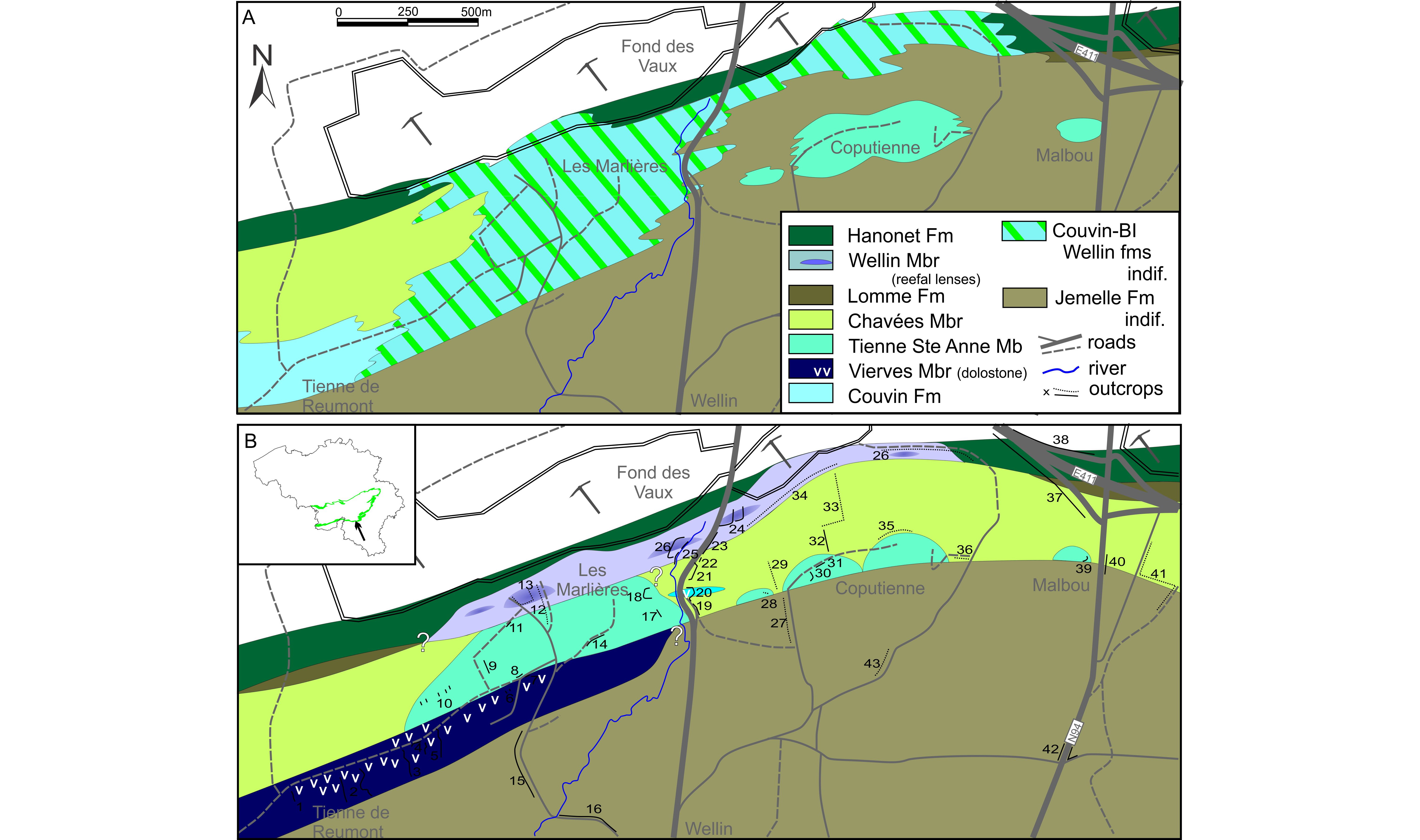
Figure 11. Geological map of the Wellin and Fond des Vaux area. Comparison between A. the map drawn by Dumoulin & Blockmans (2013a) and B. the new interpretation. Numbers are outcrops and transects in ploughed fields in the area (see Appendix 1).
3.4.5. Tienne Sainte-Anne Member
61Synonyms: ‘Co2c R’ in Bultynck (1970), ‘BI’ on the geological maps.
62Key sections: Macon and Salles, Tienne al Chapelle in Couvin, Tienne Sainte-Anne in Nismes, Coputienne and Fond des Vaux (FdV 3 in Godefroid, 1968) in Wellin (Figs 1, 11 and Appendix 1).
63Description: The bioherms developed in the upper part of the ‘Couvinian’ are long known (Maillieux, 1919b, 1938) and occur mainly in two zones: between Macon and Nismes and in the Wellin area. Bultynck (1965) described the Tienne al Chapelle (Couvin) bioherm; Bultynck (1966) described the Tienne Sainte-Anne reef (Nismes) and Bultynck (1970) described the Macon and Salles reefs. Barchy & Marion (1999, 2001) recognised additional reefs between Chimay and Couvin. In the Wellin area, the Coputienne reefs were noticed by Dumon & Maillieux (1937) and the Jeumont reef was identified by Godefroid (1968). Additionally, Dumoulin & Blockmans (2008) mapped the Les Marlières and Malbou reefs (Fig. 11). The largest bioherm exposed in Les Marlières (Wellin) reaches 200 m in thickness and c. 1000 m-long, but most of the others are c. 100 m-thick and a few hundred of metres in diameter. The lithological succession is similar in all reefs. It starts with thick roughly-bedded crinoidal, commonly yellowish rudstone covered by massive and lamellar stromatoporoids and tabulate corals (Fig. 12A). Thin shaly intercalations are not uncommon between crinoidal beds. The fauna is dominated by stromatoporoids and alveolitid tabulate corals, Heliolites and large solitary rugose corals (Acanthophyllum and Cystiphylloides). The rugose coral Cyathophyllum forms large (up to 1 m) massive colonies in the bioclastic facies associated to the stromatoporoid beds. Upwards finer-grained facies developed, with reddish bioclastic wackestone in which stromatactoid cavities are frequent (Figs 12C, 12D). This core facies was observed only in larger reefs (e.g. Tienne al Chapelle in Couvin, Tienne Sainte-Anne in Nismes, Fond des Vaux in Wellin). The uppermost facies are often whitish bioclastic wackestone-packstone with stromatoporoids and massive tabulate corals.
64Age: Bultynck (1970) reported the conodont Polygnathus linguiformis curvirostratus in the bedded crinoidal limestone at the base of the Tienne Saint-Anne reef and Polygnathus angustipennatus in the upper facies of the Macon reef (Fig. 3). It appears that the reef is situated within the eiflius zone but Bultynck (1970) suggest that their base could still be in the kockelianus zone. Consequently, the reef growth was terminated before the deposition of the sandy deposits of the Lomme Fm and equivalents. Where these sandy deposits are not present the reef is directly overlaid by the Hanonet Fm (i.e. in Tienne al Chapelle in Couvin and in Baileux, cf. Barchy & Marion, 1999; Les Marlières in Wellin, cf. Dumoulin & Blockmans, 2008).
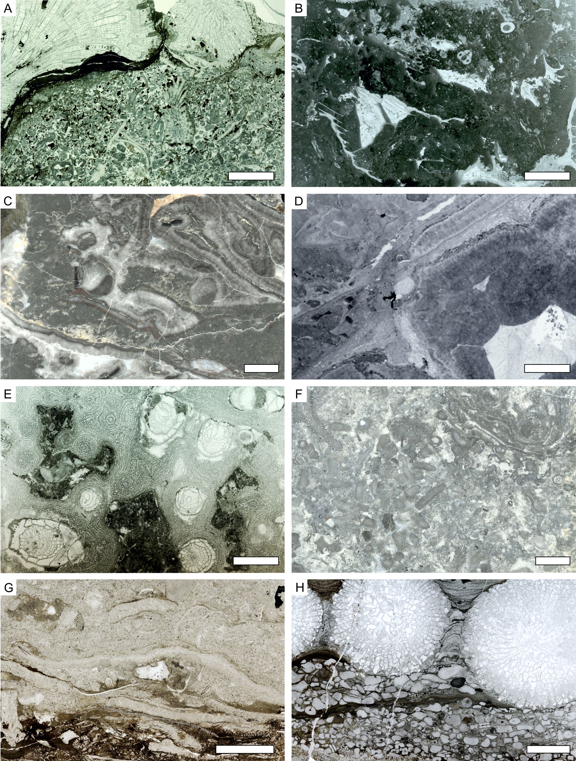
Figure 12. Illustration of some macro- and micro-facies of the Tienne Sainte-Anne and Wellin members. A. bioclastic rudstone with solitary rugose corals and Heliolites, basal facies of the Tienne Sainte-Anne Mbr, Tienne Sainte-Anne section (thin section SFC/2); B. bioclastic mudstone with stromatactoid cavities, core facies of the Tienne Sainte-Anne Mbr, Tienne al Chapelle (TACI/1); C. stromatoporoid and chaetetid coverstone with abundant fine-grained matrix and cement-filled cavities, Tienne Sainte-Anne Mbr, Fond des Vaux section (polished slab FdVIIIA/6); D. same facies in thin section, with abundant cement bothryoids in cavities, Fond des Vaux section (FdVIIIA/6c); E. coral and stromatoporoid framestone in the reefal part of the Wellin Mbr (Hanonet Fm), Fond des Vaux ‘cimetière de voiture’ (thin section FdVII/5); F. bioclastic packstone-grainstone of the Wellin Mbr, ‘Marbre Florence de Wellin’ disused quarry (polished slab FdVIV/1); G. sandy bioclastic packstone with tabulate corals, biohermal lense from the Lomme Fm, Mesnil-Favay section (thin section MF/10); H: silty coarse bioclastic rudstone with large Mesophyllum sp. from the Wellin Mbr, Aisne creek section (thin section AVI/13b). Scale bars equal 10 mm for all.
3.5. Lomme Formation
65The Lomme Fm is a dominantly sandstone unit divided into two members in the type section in Jemelle. Its thickness increases eastwards from Wellin to Resteigne where it reaches 130 m (Dumoulin & Blockmans, 2013a) up to the Aisne area (Marion & Barchy, in press). Sandstone and sandy siltstone described in the uppermost part of the Jemelle Fm in the Couvin-Chimay area (Bultynck, 1970; Barchy & Marion, 1999) correspond to local laterally-limited development of the Lomme Fm. It seems that these lenses-like sandy bodies occupy the spaces between bioherms of the Tienne Sainte-Anne Mbr.
66Age: In the Jemelle section, only the brachiopod Arduspirifer intermedius and the conodont Polygnathus angustipennata indicate the upper Eifelian eiflius to ensensis zones (Bultynck et al., 1991). In Forrières, interstratified crinoidal limestone yielded the brachiopod Uncinulus goldfussi which is only known from the Hanonet Fm in the Couvin area (Godefroid, 1968), suggesting the same age for the Wanne Mbr in Forrières and Jemelle (Fig. 3). Bultynck (1970) reported the conodont Tortodus intermedius from the sandstone in the Couvin area whereas the sandy siltstone attributed to the top of the Jemelle Fm in Couvin by Bultynck & Hollevoet (1999) yielded T. intermedius and P. ensensis. These conodonts indicate the same age, across the eiflius to ensensis standard zones (Bultynck et al., 1991).
3.5.1. Fond des Valennes Member
67Key sections: Jemelle railway section, Jemelle quarry section, Forrières road section, Aisne creek section (Fig. 1 and Appendix 1).
68Description: The Fond des Valennes Mbr (c. 70 m) is mainly shaly and silty with frequent thin beds of arkosic and/or micaceous sandstone. The fauna is not diverse (mainly brachiopods, rare corals). In Forrières (section 7 in Godefroid, 1968) and in Mesnil-Favay, small bioherms are developed in the uppermost part of the Fond des Valennes Mbr. In Forrières, the reef is c. 1 m-thick and composed of bulbous stromatoporoids and tabulate corals (favositids, alveolitids) and Heliolites. The matrix is very argillaceous and abundant. Solitary and rare colonial rugose corals (Thamnophyllum) occur mainly below the stromatoporoid horizon. In Mesnil-Favay, the tabulate corals dominate (Fig. 12G). Note that the reef reported as ‘Co2d’ by Lessuise et al. (1979) in the ‘Grotte de Magni’ section near Marenne is in fact the lower Givetian biostrome of the Trois-Fontaines Fm but developed within the Marenne sandy Member (Barchy et al., 2004). Similarly, the sandy facies attributed to the Lomme Fm by Dejonghe & Hance (2008) is the Marenne Mbr as well, hence their interpretation of the lenticular morphology of the Hanonet Fm is not sustained.
3.5.2. La Wanne Member
69Key sections: Jemelle quarry, Aisne creek section.
70Description: The Wanne Mbr (c. 40 m) is dominated by thick beds of massive sandstone, often micaceous, with occasional beds of sandy shale and some carbonate (crinoidal) nodules in the upper part. Plant fragments occur in the sandstone. The top of the formation is marked by the progressive increase in carbonate announcing the Hanonet Fm.
3.6. Hanonet Formation
71Key section: Monts de Baileux quarry, La Couvinoise quarry in Couvin, Roche Nanette quarry in Nismes, Dourbes railway tunnel section, Resteigne disused quarry, Jemelle quarry (Fig. 1 and Appendix 1).
72Description: In the stratotype in La Couvinoise quarry, Bultynck (1970) and Bultynck & Hollevoet (1999) describe the lithological succession in three units (the lowermost part of the formation is not exposed) (Fig. 3):
-
A lower unit (‘a’ in Bultynck, 1970, c. 10 m) is an alternation of dark argillaceous and pyritic fine-grained limestone with an abundant but poorly diverse fauna (brachiopods, solitary rugose corals, coiled nautiloids).
-
A middle unit (‘b’ in Bultynck, 1970, c. 25 m) is similar to the first one but the shale is dominant over the limestone and the colour is lighter. The fauna is abundant with thin ramose tabulate corals and common Calceola sandalina.
-
An upper unit (‘c, d, e’ in Bultynck, 1970, c. 15 m) displays two horizons rich in lamellar stromatoporoids and tabulate corals forming biostromes in a very argillaceous matrix. The two biostromes are separated by a 2 m-thick unit of dark carbonate shale (Bultynck et al., 1991).
73The ‘Pondrôme Mbr’ introduced by Godefroid (1995) at the top of the Jemelle Fm in the eponymous section yielded the same fauna than the lower part of the Hanonet Fm in its stratotype (Bultynck & Hollevoet, 1999). Therefore, it is considered as a local facies characterised by the abundance of shaly beds. The Hanonet Fm has a thickness of 65 m in Pondrôme as in Couvin. In Resteigne, the formation is 30 m-thick and then it decreases towards the east to reach only 12 m in Hampteau and a few tens of metres in Ferrières (Marion & Barchy, in press).
74Age: Bultynck & Hollevoet (1999) investigated the conodont fauna of the Hanonet Fm in Couvin where they reported in the lower part Polygnathus ensensis, P. linguiformis forma γ and Icriodus regularicrescens pointing to the ensensis conodont zone (Fig. 3). The base of the hemiansatus zone (base of the Givetian) is recognised in the upper part of the unit ‘a’, i.e. 12 m above the base of the section, by the entry of P. hemiansatus and the occurrence of Ozarkodina bidentata. Therefore, most of the formation belongs to the Givetian. In Jemelle, the base of the formation yielded Icriodus nodosus, I. symmetricus, Neoprioniodus armatus, Ozarkodina ballai and Scolopodus sp. still in the ensensis zone (Bultynck & Hollevoet, 1999). However the same age is suggested for the underlying Wanne Mbr, suggesting therefore a probable diachronism of the boundary between the Lomme and Hanonet Fm, the base of the latter being slightly younger in the eastern areas (Bultynck et al., 2000).
3.6.1. Wellin Member
75The name Wellin Formation was introduced by Dumoulin & Blockmans (2008) for the limestone unit yet named ‘Formation X’ by Coen-Aubert (1989). It is described from a single section in the Fond des Vaux, north of Wellin and was supposedly restricted to this single locality (Dumon & Maillieux, 1937; Coen-Aubert et al., 1991). Recent investigations (Fig. 11) however seem to indicate that the Wellin Fm is a variation within the Hanonet Fm and thus shifted to be a member of that formation.
76Key sections: Baileux zoning, Fondry des Chiens section in Nismes, Fond des Vaux section in Wellin, Hampteau disused quarry, Aisne creek section (Fig. 1 and Appendix 1).
77Description: The lithological succession is described in great detail by Coen-Aubert et al. (1991). The base of the member, hidden by a hiatus after Coen-Aubert (1990), is in fact visible above the wall in the Fond des Vaux section and shows a rapid development of coarse-grained crinoidal and bioclastic grainstone above the shale of the Chavées Mbr. Above this transition, the member displays:
-
A first unit visible in the road embankment (c. 30 m-thick) of well-bedded coarse-grained crinoidal grainstone with an abundant fauna of corals and stromatoporoids. Shaly interbeds are often developed and yield the same abundant fauna of corals (including large domal colonies of Cyathophyllum), brachiopods and bryozoans.
-
A hiatus c. 30 m-thick, more or less completed by discontinuous outcrops in the bed of the nearby Ry d’Ave creek displaying crinoidal grainstone facies with very thick lamellar stromatoporoids. Small colonies of fasciculate rugose corals and ramose tabulate corals occur. This limestone is light grey or slightly greenish.
-
A c. 20 m-thick unit of massive light grey limestone rich in large bulbous and domal stromatoporoids. The matrix between the stromatoporoids is often abundant and rich in tabulate and rugose corals (including Sociophyllum, Fig. 12E). This massive facies was quarried as an ornamental stone known as ‘Marbre Florence de Wellin’ (Fig. 12F) in the small quarry on the left bank of the Ry d’Ave creek (FdV 4 section in Godefroid, 1968 and Bultynck et al., 1991).
-
A recurrent bedded unit (45 m-thick) of coarse-grained crinoidal rudstone with abundant debris of stromatoporoids and tabulate corals. At least two reefal beds (or lenses) c. 2 m-thick occur within the crinoidal succession. They are mainly composed of stromatoporoids and tabulate corals but fasciculate and cerioid rugose corals (Xystriphyllum, Sociophyllum) are not rare. In Aisne, the equivalent is a crinoidal rudstone rich in corals and commonly slightly silty (Fig. 12H) as already noticed by Burnotte & Coen (1981).
78The contact with the typical fine-grained dark limestone of the Hanonet Fm in the Fond des Vaux quarry is not visible but occurs in a <10 m hiatus north of the ‘Cimetière des voitures’ quarry where the upper facies of the Wellin Mbr are exposed (Coen-Aubert et al., 1991). Laterally (wooded ridge south of the Fond des Vaux eastern quarry), the crinoidal grainstone passes progressively to the typical facies of the Hanonet Fm. Intermediate facies between the crinoidal rudstones of the Wellin Mbr and the more typical dark, fine-grained and argillaceous facies of the Hanonet Fm are also exposed in the Monts de Baileux quarry (Mabille & Boulvain, 2008) and in the disused Roche Nanette quarry in Nismes (Coen-Aubert, 1996). In both cases the Wellin Mbr crops out less than 200 m away.
79Upwards, the crinoidal limestone of the Wellin Mbr grades into the purer crinoidal limestone to the Trois-Fontaines Fm. If the boundary between the two is not easily placed in some localities, the main differences are the massive aspect of the Trois-Fontaines basal beds compared to the bedded limestone of the Wellin Mbr. Moreover, there are often small shaly interbeds in the latter which tend to disappear in the massive beds.
80In the type section, the Wellin Mbr is c. 125 m-thick but in the Baileux and Fondry des Chiens section, it reaches 100 m (Préat et al., 2007; Mabille & Boulvain, 2008) with a limited development of reefal facies. In Hampteau, only 15 m of crinoidal rudstone are present. In Aisne, only two c. 10 m-thick crinoidal units rich in corals (Fig. 12H) crop out, separated by a 50–60 m exposure gap.
81Age: Godefroid (1968) indicated the occurrence of Polygnathus xylus in the stromatoporoidal massive part of the member. Bultynck (1987) however revised this material and determined the conodont Polygnathus ensensis, guide for the standart ensensis zone in the upper part of the Eifelien. Bultynck & Godefroid (1974) noted the presence of Ozarkodina bidentata in the upper part of the member, a species only known in the ensensis zone in Belgium. In the Fond des Vaux section, the Wellin Mbr is therefore equivalent to the lower part of the Hanonet Fm as yet suggested by Maillieux (1938). In the Fondry des Chiens section, Bultynck (1987) and Coen-Aubert (1992) reported Ozarkodina bidentata in the lower part of the crinoidal limestone and Polygnatus hemiansatus in the upper part. In this area, the Wellin Mbr crosses the Eifelian-Givetian boundary and covers the whole Hanonet Fm (Bultynck & Dejonghe, 2001). In the Aisne valley, Burnotte & Coen (1981) identified the conodonts Polygnathus linguiformis forma γ, Ozarkodina cf. bidentata and Icriodus cf. obliquimarginatus indicating the ensensis zone (Fig. 3).
3.7. Rivière Formation
82Key sections: Rivière and Tantachau sections in the Meuse valley, Aisemont section (Fig. 1).
83Description: The Rivière Formation, introduced by Bultynck et al. (1991), includes two members regarded as two formations by Bultynck & Boonen (1976, see therein for detailed description): the Rouillon and Claminforge members. Bultynck & Dejonghe (2001) refined the definition of the overlying Névremont Fm by placing its base in what was previously considered to be the top of the Rivière Fm. The Rouillon Mbr begins with a c. 15 m-thick unit of shaly and sandy red beds overlaid by the Tailfer Conglomerate Horizon composed of small pebbles embedded in a fine-grained light colour matrix. It is overlain by a second unit of greenish to reddish shale and sandstone with rare limestone intercalation (often dissolved) up to 45 m-thick. The Claminforge Mbr is a mixed siliciclastic-carbonate unit where the limestone content and marine character increases upwards. It ends with the deposition of more argillaceous and nodular limestone of the Névremont Fm (Coen-Aubert, 2000). Its thickness is c. 10 m-thick in the Meuse valley, and increases towards the NW and reaches 30 m-thick in its stratotype in Aisemont then decreases westwards to reach c. 25 m in its westernmost outcrop (Cornet & Briart, 1874).
84Age: Carbonate beds above the Tailfer Conglomerate Horizon yielded Protognathus linguiformis forma α, Icriodus corniger, I. retrodepressus, I. curvirostratus, I. introlevatus and I. expansus (Bultynck & Boonen, 1976) allowing to assign this unit to the kockelianus to lower eiflius zones, i.e. an equivalent to the top of the Cul d’Efer Mbr or base of the Abîme Mbr. The base of the Claminforge Mbr yielded the same association without I. corniger but with Bipennatus montensis (Bultynck et al., 1991) suggesting the upper part of the costatus zone, i.e. top of the Couvin Fm in its stratotype. The upper part of the formation yielded Icriodus regularicrescens, I. struvei and I. amabilis (Bultynck et al., 1991) suggesting the upper part of the eiflius zone and the ensensis zone, i.e. equivalent to the top of Jemelle-base of Hanonet Fm. Directly above this level, the limestone yielded an association with I. obliquimarginatus indicating the lower Givetian hemiansatus zone (Bultynck & Boonen, 1976). Gouwy & Bultynck (2003b) indicate in this level I. lindensis and I. brevis suggesting also the basal Givetian hemiansatus zone but a single specimen of I. ambilis indicates the ensensis zone c. 1 m below the upper boundary of the member.
3.8. Pépinster Formation
85The Pépinster Fm has not been investigated in this study. The present description is thus based on Asselberghs (1952, 1955), Liégeois (1956) and Hance et al. (1994). Note that the Pépinster Fm has been mapped along the northern limb of the Dinant Synclinorium from the Ourthe area up to the Hoyoux area westwards (Mottequin & Marion, in press) where it passes laterally to the Rivière Fm (Delcambre & Pingot, 2018).
86Description: Above the basal conglomerate of the Vicht Fm (Hance et al., 1994), the Pépinster Fm starts with a c. 10 m-thick unit of red and green shale and siltstone with carbonate and sulphate nodules with rare sandstone beds. A 24 m-thick package of greenish sandstone and conglomeratic sandstone is individualized as the Heusy Mbr (Hance et al., 1989). Plant macrofossils occur in the lower part whereas the upper part is carbonate and rich in marine fossils (brachiopods and tentaculites). The rest of the formation is dominated by red shale and siltstone.
87Age: In the northern part of the Vesdre area (Goé Nappe), the Vicht Fm underlying the Pépinster Fm is dated of the ‘Lem’ subzone of the AD palynozone, i.e. lower Givetian. In the southern part (Gileppe Nappe) however, the Pépinster Fm is dated ‘pre-Lem’ (Hance et al., 1994) and correlated after Streel et al. (1987) with the ensensis conodont zone. Gouwy & Bultynck (2003a) suggest the inclusion of the lower part of the Pépinster Fm to the costatus conodont zone. The appearance of stringocephalid brachiopods and the rugose coral Argutastrea tenuiseptata in the limestone beds c. 10 m below the top of the Fm (Bultynck et al., 1991) confirms that the upper part of the Pépinster Fm is Givetian (at least lower varcus conodont zone; Bultynck et al., 1991).
4. Sequence stratigraphy
88The recognition of the third-order sequences is based on the identification of remarkable surfaces and by the morphology of the depositional units as defined by Posamentier & Vail (1988) and Hunt & Tucker (1993), emended by Plint & Nummedal (2000). Figure 5 displays the geometrical distribution of the lithostratigraphic units along the south and southeastern limb of the Dinant Synclinorium with the top of the Couvin Fm (Abîme and Vierves members) taken as the horizontal reference. Figure 13, however, presents the same succession in stratigraphy demonstrating the temporal relationship of the units.
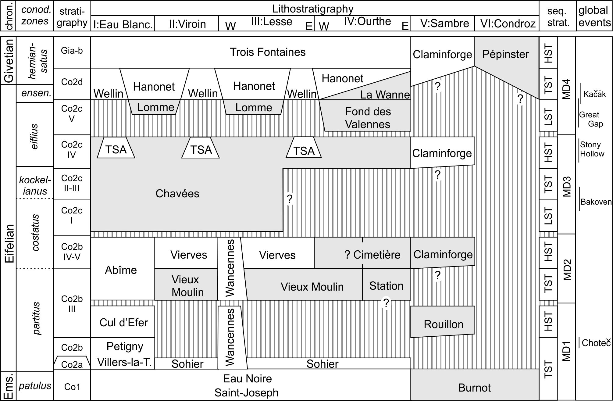
Figure 13. Sequence stratigraphic interpretation of the Eifelian succession of Belgium. Legend: HST: highstand system tracts, LST: lowstand system tracts, TST: transgressive system tract; TSA: Tienne Sainte-Anne Mbr, MD1-MD4: Middle Devonian 3rd order sequences; stratigraphic symbols Co1 to Gia-b after Bultynck (1970). Grey units are siliciclastic, white units are carbonate, stripped areas represent hiatuses.
4.1. Middle Devonian Sequence MD1
89The first Middle Devonian sequence starts in the late Emsian with the deposition of a transgressive lag composed of haematite-coated bioclasts usually described as ‘oligiste oolithique du Couvinien’ and mined as an iron ore up to the 19th century in the Chimay area. This lag deposit can be traced from Wignehies (France) to Olloy-sur-Viroin and then again between Wellin and Jemelle with a reduced development (Delmer, 1913). In the western area, the haematitic horizons are situated at the top of the Hierges Fm, in the serotinus conodont zone but they get younger towards the east. In the Jemelle section (Maillieux, 1913) they occur in the upper part of the Saint-Joseph Fm, i.e. in the patulus zone.
90In the Couvin area, the transgressive system tract (TST) is recognised in the thick succession of the Saint-Joseph and Eau Noire formations showing a clear progradational trend, with no clear evidence for the presence of a lowstand system tract (LST). The Villers-la-Tour Mbr composed the upper part of the TST whereas the Petigny Mbr corresponds to the maximum flooding zone of the sequence where the relative water depth is maximum with the development of dysoxic facies. The Cul d’Efer Mbr is identified as the highstand system tract (HST) with its wide development and homogenous composition. Moreover, the sediments display shallowing-upwards sequence that became more dolomitised upwards. The dolomitic unit could probably be considered as the falling-stage system tract (FSST). The sequence boundary is placed at the top of the dolomitic massive limestone in the Cul d’Efer Mbr (top of sub-unit p in Bultynck, 1970).
91In the Viroin area, the lower members of the Couvin Fm are not recorded, with the exception of the Sohier Horizon that corresponds biostratigraphically to the lower part of the Villers-la-Tour Mbr and that records the transgressive part of the sequence.
92In the Wancennes area, the upper part of the TST is recorded in the crinoidal rudstone-stromatoporoids alternations whereas the HST is recorded in the reef-core facies (light grey stromatoporoids-corals framestone and bafflestone). Though there is no clear evidence for an emersion of the reef, the succession of facies suggests two shallowing-upwards tendencies that probably point to the sequence boundary within the reef (see 4.2.).
93In the Jemelle area, it seems that a hiatus covers the lower partitus zone as the Station and Cimetière members only yielded fauna suggesting the upper part of the partitus and costatus zones. Only the Sohier Horizon recorded a part of the TST.
94Along the northern area of the Namur-Dinant Basin (Rivière and Aisemont sections), only the HST can be identified in the lower unit of the Rouillon Mbr resting on the Emsian red conglomerate of the Burnot Fm (Fig. 13).
95This first sequence MD1 covers the the patulus to costatus (partim) conodont zones and corresponds to a 300 m-thick deposit in the Couvin-Nismes area and in the Wellin area. In eastern areas, only the lower part is recorded in a c. 100 m-thick sequence.
4.2. Middle Devonian Sequence MD2
96The TST of this second sequence is recorded in the lower part of the Abîme Mbr displaying a superposition of biostromes then a more argillaceous interval, often dark (Saint-Remy Facies) that corresponds probably to the maximum flooding zone. The HST is recorded by various high-energy facies in the Abîme Mbr (crinoidal grainstone in the Chimay area, stromatoporoid biostromes in the Couvin area, coral bioherm in the Nismes area) all capped by an erosive surface interpreted as the sequence boundary overlaid with the Chavées Mbr.
97The dark argillaceous wackestone with corals occurring in the Wancennes reef is here interpreted as the (?LST-)TST of the second sequence. It passes upwards to a bafflestone with rugose and tabulate corals and locally abundant cement-filled cavities. It evolved upwards to the shallowing-upwards succession of reefal facies culminating in the massive light grey limestone with large stromatoporoids. Few outcrops expose the boundary with the overlying shaly Chavées Mbr of the Jemelle Fm, however the clear-cut change of facies advocates for its interpretation as a sequence boundary.
98The Vieux Moulin Mbr is interpreted as the LST and TST of this second sequence, filling the areas where the Couvin and Wancennes formations are not developed (Fig. 13). A part of the member (possibly the Najauge Sandstone) is contemporaneous with the Abîme Mbr and Wancennes Fm. The siliciclastics pass upwards to the carbonate Vierves Mbr in which shallow-water stromatoporoid facies is locally developed. The member is interpreted as the HST as its facies is homogenous between Olloy-sur-Viroin and Wellin and for its lateral continuity. In the Vierves-sur-Viroin section, the top of the member is a slightly dolomitic bioclastic grainstone capped by an undulating surface blanketed by an argillaceous limestone bed. This surface is interpreted as the sequence boundary on top of which the Chavées Mbr deposited. Eastwards, between Froidlieu and Wellin, the top of the Vierves Mbr displays an increasing dolomitisation that affect up to the upper half of the member. Again this dolomitisation points to the emersion of the carbonate shelf at the end of the sequence MD2.
99East of Wellin, the sequence MD2 is hardly detectable in the Vieux Moulin Mbr (?LST-TST) and possibly the Station and Cimetière members (HST). The lack of precise biostratigraphic data however hampers the correlations of these members with the carbonate successions known westwards. Their sequential interpretation remains therefore hypothetical.
100In the proximal areas, it seems that only the HST is recorded in the limestone unit at the base of the Claminforge Mbr of the Rivière Fm that is dated by conodonts of the costatus zone (Bultynck & Boonen, 1976).
101The second sequence covers most of the costatus zone. In the Couvin area, it corresponds to an 80 m-thick succession whereas in the Wancennes area, it covers the c. 100 upper metres of the reef. In the eastern areas, the sequence records c. 150 m of siliciclastic and carbonate rocks. The sequence MD2 seems to be shorter than the MD1 if comparing the thickness of their respective deposits.
102In eastern North America, Brett et al. (2011) defined a third order sequence ‘Eif-1’ covering the patulus-costatus conodont zone interval. This rather long sequence could possibly correspond to the presently defined sequences MD1 and MD2. The second sequence being seemingly shorter and possibly of lesser amplitude, it might have not be recognised or individualised in the North American example. The sequence MD1 lacking in most part of the NDB, it could also be in hiatus in North America but the poor biostratigrahic control across the Emsian-Eifelian boundary in most part of the North American basin (Brett et al., 2011) precludes further interpretation.
4.3. Middle Devonian Sequence MD3
103In all areas, the sequence MD3 is entirely recorded in the Jemelle Fm. In western areas, the Chavées Mbr starts on the erosive surface capping the Couvin Fm with an alternation of shaly and carbonate beds very rich in fauna indicating the kockelianus and eiflius zones. This first unit is identified as the LST-TST. Eastwards, this unit decreases in thickness and disappears entirely in Wellin where the first deposits of sequence MD3 are already eiflius in age. This shaly deposit rich in limestone beds, also known in the Couvin area, includes locally the bioherms of the Tienne Sainte-Anne Mbr. They are interpreted as the HST. It has to be noted that these small reefs are situated very high in the Jemelle Fm and they display a clear-cut boundary with the overlying Hanonet Fm, suggesting that a sequence boundary occurs at their top and that the emersion at the end of the sequence most likely stopped their development.
104In the proximal area, the carbonate Claminforge Mbr yielded a conodont association indicating the upper part of the eiflius zone (Bultynck & Boonen, 1976), which suggests a correlation with the HST of the sequence (Fig. 13).
105The sequence MD3 covers the top of costatus to kockelianus conodont zones and corresponds to c. 260 metres of sediment in the Couvin area and c. 200 m in the Wellin and Jemelle area.
106The sequence MD3 could be correlated with the sequence ‘Eif-2’ sequence of Brett et al. (2011) in eastern North America that covers the costatus-kockelianus(-eiflius) conodont zone interval.
4.4. Middle Devonian Sequence MD4
107This last third-order sequence is the most homogenous along the southern limb of the Dinant Synclinorium by its succession of facies. It starts with the deposition of 10–30 m of sandy siltstone and sandstone that filled depressions between the topographic highs inherited from the bioherms of the Tienne Sainte-Anne Mbr in the Chimay-Nismes area (Bultynck, 1970) and Wellin. Eastwards the deposition is less affected by the palaeotopography and more regular in thickness (Godefroid, 1968). This sandy lower part of the Lomme Fm is interpreted as the LST of the sequence MD4. The TST of is recorded in the upper part of the Lomme Fm and the Hanonet Fm. In the Couvin area, its lower part belongs to the eiflius zone (Bultynck, 1970) and yielded the same conodont fauna than the Lomme Fm in the Forrières area (Godefroid, 1968). The base of the Hanonet Fm is therefore diachronic and is younger towards the NE with a base within the ensensis zone in the Jemelle area (Godefroid, 1995; Bultynck & Hollevoet, 1999). Where the bioherms of Tienne Sainte-Anne Mbr are developed, they are directly overlaid by the Hanonet Fm. In such situation, the Wellin Mbr is often developed (e.g. Baileux, Nismes, Wellin), possibly because they acted as topographic highs. In most section, the Hanonet Fm displays a lower part relatively argillaceous and dark (dysaerobic?) that possibly corresponds to the maximum flooding zone. Above this unit, a shallowing-upwards trends is clear and culminates with the deposition of the massive crinoidal limestone at the base of the Trois-Fontaines Fm (lower Givetian) in which stromatoporoids-corals bioherms are often developed. This c. 20 m-thick massive part if interpreted as the HST of the sequence, its top commonly displays traces of emersion (Boulvain et al., 2011) interpreted here as the sequence boundary. The restricted limestone with stromatolitic sequences above the emersion surface constitutes the LST-TST of the next sequence.
108In the Aisemont area, the upper part of the Claminforge Mbr is correlated with the base of the Trois-Fontaines Fm (Bultynck et al., 1991), so again, it seems that only the HST of the sequence is recorded (Fig. 13). By pure biostratigraphic correlation, the basal conglomerate of the Pépinster Fm (= Vicht Fm in Hance et al., 1994) could possibly represent the TST of the sequence MD4. The Heusy sandstone Member could possibly record the HST but further analyses and dating are required.
109This last sequence covering the Eifelian-Givetian boundary extends from the upper Eifelian kockelianus to lower Givetian hemiansatus conodont zones. It corresponds to 110–120 metres of sediment in the Couvin area, c. 160 m in the Wellin area, 110 m in the Jemelle area and 60 m in the Hotton area.
110The sequence MD4 could be correlated with the ‘Eif-Giv’ sequence of Brett et al. (2011) in eastern North America that covers the kockelianus-hemiansatus conodont zone interval.
5. Correlation with global events
111The Eifelian recorded several bioevents and extinctions events, mainly in the pelagic fauna (Walliser, 1996; House, 1996; Brocke et al., 2016). The oldest one is the Choteč event (Chlupáč & Kukal, 1986, 1988) commonly associated with the development of anoxic sediments in basinal sections. Gouwy & Bultynck (2003a) suggested that the transgression associated with the demise of the ‘first biostrome’ of the Couvin Fm in the type area might correspond to that deepening event. The recognition of dysaerobic fine-grained dark and unbioturbated limestone facies in the Petigny Mbr near the boundary between the partitus and costatus conodont zone is a significant argument to place the Choteč event in Belgium (Fig. 13). In fact the transgressive part of the sequence MD1 has possibly triggered the invasion of basinal anoxic water on the platform, creating short-living dysaerobic conditions, particularly during the maximum flooding interval when the relative depth was maximum due to the increased accommodation of the basin. A peculiar fauna developed during this interval, notably bivalves and cephalopods (Fig. 4B), reflecting the usually observed dysoxia (Vodrážková et al., 2013). However there is no significant extinction among corals and brachiopods as the faunal composition of the ‘first biostrome’ and ‘second biostrome’ is very similar. One explanation could be that the fauna migrated away during the dysaerobic event and then colonised again the seabed when normal conditions returned afterwards. Avlar & May (1997) and Ernst et al. (2012) documented a similar pattern amongst stromatoporoids and corals through the Choteč event interval in the northern Rhenish Massif. In contrast, the brachiopods seem to have suffered this crisis as suggested by Struve (1982b) and May (1995, 1997) with the extinction of the typically early Eifelian species Paraspirifer cultijugatus and Alatiformia alatiformis. The latter two are however unknown in strata younger than the Eau Noire Fm (lower partitus zone) in southern Belgium, probably for facies reasons (Godefroid, 1968; see also Fig. 3).
112Recently Van Viersen et al. (2019) introduced the ‘Vieux Moulin event’ to describe a horizon rich in well-preserved trilobites. However, this event has no impact neither on fauna nor on deposition and has only a very local extension. Therefore it should be seen as a peculiar and possibly time-limited tapho-facies rather a biotic event.
113The Bakoven event, situated in the (kockelianus-)eiflius conodont zone (De Santis & Brett, 2011) corresponds to an abrupt deepening and correlative development of anoxic facies in basinal settings. It is tentatively correlated with the maximum flooding zone of the sequence MD3, i.e. in the middle shaly part of the Chavées Mbr (Fig. 13). A minor change in the brachiopod fauna in the ‘Co2c II’ unit of the Chavées Mbr might be the only argument for placing the event. The Bakoven event is followed by the Stony Hollow event (kockelianus zone) that seemingly corresponds to a regressive event in the type area (De Santis & Brett, 2011). It could correspond either to the decrease of relative depth during the deposition of the HST of sequence MD3 (i.e. Tienne Sainte-Anne Mbr) or to the emersion related to the sequence boundary at the top of the Jemelle Fm. Alternatively, it could be the equivalent of the ‘Great Gap’ (see below). The Stony Hollow does not seem however to be related to any extinction or turnover in corals, conodonts and brachiopods – i.e. stratigraphic distributions of fauna in Godefroid (1968) and in Bultynck (1970).
114The upper Eifelian succession often displays non fully-marine deposits or hiatuses in proximal settings that were described as the ‘Middle Devonian Great Gap’ by Struve (1982b) often called ‘Struve’s Great Gap’ afterwards (Bultynck & Hollevoet, 1999). It is interpreted as the result of a regressive pulse with erosion on continents feeding the marginal shelves with siliciclastic sediments (Struve, 1990). The age of this ‘Great Gap’ varies from area to area, covering an interval ranging from the costatus to hemiansatus zones. However it is more commonly restricted to the ensensis zone (Weddige, 1988; Bultynck & Hollevoet, 1999). In southern Belgium, the development of sandstone facies of the Lomme Fm corresponds to it both biostratigraphically and by the shift in sedimentation towards non fully-marine deposition (Fig. 13). In proximal areas, this lowstand is missing but restricted marine sediments and red beds occur in the Pépinster Fm below and above the ensensis zone, acknowledging Struve’s conception of a longer Great Gap in proximal settings. In other proximal area, the depositional hiatus recognised in the Rivière Fm (e.g. in the Aisemont section) seems to correspond to the ‘Great Gap’ as well.
115The Kačák event consists of two separated events (Chlupáč & Kukal, 1988): the lower Kačák event or otomari event taking place in the beginning of the ensensis zone and the Kačák event s.s. at the end of the ensensis zone before the Eifelian-Givetian boundary (Schöne, 1997; DeSantis & Brett, 2011; Königshof et al., 2016). In Belgium the Kačák event s.l. corresponds to the Hanonet Fm and parts of the Lomme Fm, i.e. the transgressive system tract of the sequence MD4 (Fig. 13). As suggested by Bultynck & Hollevoet (1999), the otomari event could possibly corresponds to the argillaceous, dark lower part of the Hanonet Fm in its stratotype but there is no evidence for dysaerobic conditions as the fauna – though rather poorly diverse – is still present in this facies. There is no extinction at this level, in the contrary the brachiopod fauna becomes more diverse (Godefroid, 1995). Moreover in the Resteigne section, Coen-Aubert (1996) describes an abundant assemblage of rugose corals belonging to the family Siphonophrentidae that are rather rare in Europe before the ensensis zone. These corals, typical of the North American Eifelian possibly represent invasive species from the East American Middle Devonian where the Kačák event is marked by the massive arrival of fauna from the Old World Realm (Oliver & Pedder, 1994; May, 1995). Similarly there is no clear extinction in the Hanonet Fm where the Kačák s.s. event is expected to be found but a faunal turnover occurs higher, in the basal Trois-Fontaines Fm (Godefroid, 1995; Coen-Aubert, 1992). This turnover is associated with a clear facies shift witnessing a change of environment (Boulvain et al., 2011).
6. Distribution of reefs and structuration of the Namur-Dinant Basin
116The transect illustrated in Figures 5 and 14 displays the geometrical distribution of the lithostratigraphic units along the southern and southeastern limb of the Dinant Synclinorium. Several reefs are noticed in the succession, in all areas but their position is not random as already suggested by Tsien (1980).
117During the sequence MD1, the ‘first biostrome’ and ‘second biostrome’ of the Couvin Fm (Villers-la-Tour and Cul d’Efer members, see descriptions in 3.2.1 and 3.2.3) deposited in the Eau Blanche area or block (I in Fig. 14). Eastwards this succession disappears, probably because the Viroin area (II in Fig. 14) was a block where less carbonate deposited during this interval. In the western Lesse block (Dion, Wancennes, III in Fig. 14) the large bioherms of the Wancennes Fm developed, possibly near synsedimentary faults. No reef has been recognised in this lower sequence east of Pondrôme.
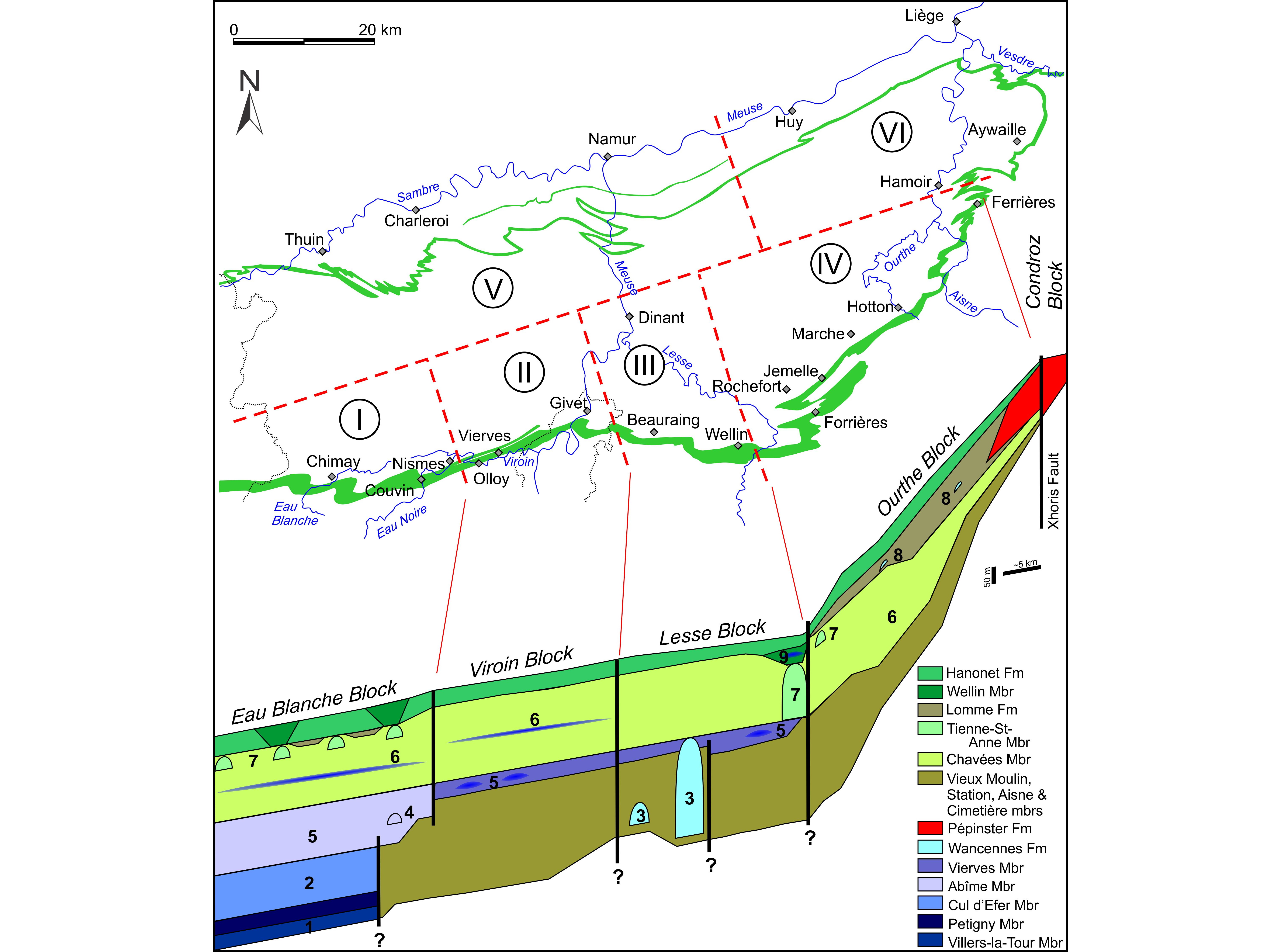
Figure 14. Reconstruction of the Eifelian sedimentation areas within the Namur-Dinant Basin and palaeogeographic distribution of the reefs (biostromes in dark blue, bioherms in light blue) and Old Red Sandstone facies (red). The distribution of facies is seemingly dictated by synsedimentary block faulting. These blocks are: I. Eau Blanche block (westwards extension unknown), II. Viroin block, III. Lesse block (possibly several sub-blocks), IV: Ourthe block, V: Sambre block (possibly several sub-blocks in the western part), VI. Condroz block (possibly several sub-blocks) dominated by Old Red Sandstone facies. Reefs: 1: ‘first biostrome’ in the Villers-la-Tour Mbr, 2: ‘second biostrome’ in the Cul d’Efer Mbr, 3: bioherm of the Wancennes Fm, 4: bioherm in the Abîme Mbr, 5: ‘third biostrome’ in the Abîme and Vierves members, 6: biostrome in the Chavée Mbr, 7: bioherm of the Tienne Sainte-Anne Mbr, 8: bioherm in the Lomme Fm, 9: bioherm in the Wellin Mbr.
118During the sequence MD2, the ‘third biostrome’ (Abîme Mbr) developed in the Eau Blanche block and small bioherms developed near its eastern margin (Roche Trouée in Nismes). Eastwards, small stromatoporoid bioherms locally developed in the Vierves Mbr in the Viroin block, as well as in the Lesse block (i.e. Eclaye, Pondrôme). East of Wellin where this unit is dolomitised, the Vierves Mbr disappears and no other reefs are known eastwards.
119During the sequence MD3, thin stromatoporoid biostromes less than 1 m-thick developed in the Chavées Mbr throughout the basin and can be traced over 100 km. The bioherms of the Tienne Sainte-Anne Mbr developed only locally in the Eau Blanche block and in the eastern part of the Lesse block (Wellin, III in Fig. 14). Again, these peculiar reefs are not known eastwards where the Eifelian succession is almost entirely siliciclastic-dominated in the Ourthe block (IV in Fig. 14).
120During the sequence MD4, small stromatoporoid biostromes are known in the Hanonet Fm (already in the lower Givetian hemiansatus zone) in the Eau Blanche block. In the eastern Ourthe block, small bioherms developed in the Lomme Fm. Locally the Wellin Mbr is characterised by lenticular reefal units such as in the eastern Lesse block (Wellin). The stromatoporoid-coral biostrome forming the base of the lower Givetian Trois-Fontaines Fm is also known all along the southern limb of the Dinant Synclinorium but its composition varies enormously from place to place and it is thicker where the Wellin Mbr is developed below as already suggested by Lecompte (1960) and Kasimi & Préat (1986).
121In conclusion, the Figure 14 clearly indicates that the position of the reefs is not random but seemingly dictated by the synsedimentary tectonic structuration of the basin. The areas described above probably correspond to individual tectonic blocks with their own lithostratigraphic succession and accommodation history: the Eau Blanche block (I in Fig. 14), the Viroin block (II), the Lesse block (III, possibly two sub-blocks), the Ourthe block (IV, along the southern margin of the Dinant Synclinorium), the Sambre block (V) and the Condroz block (VI, north of the Xhoris Fault and in the Vesdre area). All bocks are seemingly limited by synsedimentary faults as suggested by their sharp facies changes. If the N-S block boundaries are rather well constrained, the NE-SW boundary is more hypothetical due to the lack of stratigraphic information between the northern and southern limb of the Dinant Synclinorium. The orientation and boundaries are inspired by the block structuration suggested in the Frasnian by Tsien (1971) and in the Famennian by Thorez et al. (1977). This structuration in blocks probably existed since the Lower Devonian and continued to function up to the Upper Devonian and even probably to the Viséan (Poty, 1997). Sub-blocks of smaller dimensions possibly existed as suggested in the Givetian by Kasimi & Préat (1996) and Tucker & Garland (2010). In consequence, the Devonian reefs seem to be piled-up in some areas, probably because the block faulting produced accommodation and local conditions favourable for their development.
7. Acknowledgements
122This paper aims to establish a stratigraphic scheme for the Belgian Eifelian in the frame of the DeCoDE project. The author is deeply grateful to Marie Coen-Aubert, Jean-Marc Marion, Cyrille Prestianni, Bernard Mottequin, Sabine Blockmans, Francis Tourneur and Edouard Poty for their encouragement and the numerous fruitful discussions in the office and in the field, discussions that allowed preparing this revision. The paper benefits from the review and comments of Marie Coen-Aubert and Andreas May. Both are thanked for their help to improve the paper, even if the author takes the entire responsibility of his ideas.
8. References
123Asselberghs, E., 1952. Le Dévonien moyen dans la région de Harzée (bord oriental du bassin de Dinant). Bulletin de la Société belge de Géologie, de Paléontologie et d’Hydrologie, 60/3, 342–361.
124Asselberghs, E., 1955. La grauwacke de Rouillon (Couvinien) du bord oriental du bassin de Dinant. Mémoires de l’Institut géologique de l’Université de Louvain, 19, 177–221.
125Asselberghs, E. & Yans, H., 1952. Un faciès spécial du Couvinien à Ferrières. Bulletin de l’Académie royale des Sciences de Belgique, 38, 780–782.
126Avlar, H. & May, A., 1997. Zur Fauna und Stratigraphie der cultrijugatus-Schichten (Wende Unter-/ Mittel-Devon) im West-Sauerland (Rheinisches Schiefergebirge). Coral Research Bulletin, 5, 103–119.
127Barchy, L. & Marion, J.-M., 1999. Carte géologique de Wallonie : Chimay – Couvin 57/7-8. 1/25 000. Namur, Ministère de la Région wallonne, Direction générale des ressources naturelles et de l’environnement, avec une notice explicative de 89 p.
128Barchy, L. & Marion, J.-M., 2001. Carte géologique de Wallonie : Momignies – Seloignes 57/5-6. 1/25 000. Namur, Ministère de la Région wallonne, Direction générale des ressources naturelles et de l’environnement, avec une notice explicative de 75 p.
129Barchy, L., Coen-Aubert, M., Marion, J.-M. & Coen, M., 2004. Mise en évidence de la faille de Marenne sur la carte géologique Aye – Marche. Bulletin de l’Institut royal des Sciences naturelles de Belgique, Sciences de la Terre, 74, 59–71.
130Belka, Z., Kaufmann, B. & Bultynck, P., 1997. Conodont-based quantitative biostratigraphy for the Eifelian of the eastern Anti-Atlas, Morocco. Geological Society of America Bulletin, 109/6, 643–651. https://doi.org/10.1130/0016-7606(1997)109<0643:CBQBFT>2.3.CO;2
131Bertrand, M., Coen-Aubert, M., Dumoulin, V., Préat, A. & Tourneur, F., 1993. Sédimentologie et paléoécologie de l’Emsien supérieur et de l’Eifelien inférieur des régions de Couvin et de Villers-la-Tour (bord sud du Synclinorium de Dinant, Belgique). Neues Jahrbuch für Geologie und Paläontologie, Abhandlungen, 188/2, 177–211.
132Boulvain, F., Coen-Aubert, M., Da Silva, A.-C., Kershaw, S., Tourneur, F., Denayer, J., Mottequin, B. & Poty, E., 2011. Field trip 1: Givetian and Frasnian of Southern Belgium. In Aretz, M. & Poty, E. (eds), 11th International symposium on Fossil Cnidaria and Porifera - Liège, 19–29 August, 2011, Field-Guides. Kölner Forum für Geologie und Paläontologie, 20, 5–50.
133Brett, C.E., Baird, G.C., Bartholomew, A.J., DeSantis, M.K. & Ver Straeten, C.A., 2011. Sequence stratigraphy and a revised sea-level curve for the Middle Devonian of eastern North America. Palaeogeography, Palaeoclimatology, Palaeoecology, 304/1-2, 21–53. https://doi.org./10.1016/j.palaeo.2010.10.009
134Brocke, R., Fatka, O., Lindemann, R.H., Schindler, E. & Ver Straeten, C.A., 2016. Palynology, dacryoconarids and the lower Eifelian (Middle Devonian) Basal Choteč Event: case studies from the Prague and Appalachian basins. In Becker, R.T., Königshof, P. & Brett, C.E. (eds), Devonian Climate, Sea Level and Evolutionary Events. Geological Society, London, Special Publications, 423, 123–169. https://doi.org/10.1144/SP423.8
135Bultynck, P., 1965. Contribution à l'étude des corrélations stratigraphiques entre le massif schisto-rhénan et l'Ardenne – Étude d'une faunule à Conodontes dans un petit bioherme du Couvinien supérieur à Couvin. Annales de la Société géologique de Belgique, 88/3, 61–72.
136Bultynck, P., 1966. Répartition stratigraphique de quelques Conodontes dans le Couvinien. Annales de la Société géologique de Belgique, 89/6, 191–205.
137Bultynck, P., 1970. Révision stratigraphique et paléontologique (brachiopodes et conodontes) de la coupe type du Couvinien. Mémoires de l’Institut géologique de l’Université de Louvain, 26, 1–150.
138Bultynck, P., 1987. Pelagic and neritic conodont successions from the Givetian of pre-Sahara Morocco and the Ardennes. Bulletin de l’Institut royal des Sciences naturelles de Belgique, Sciences de la Terre, 57, 149–181.
139Bultynck, P., 2006. Couvinian. In Dejonghe, L. (ed.), Chronostratigraphic units named from Belgium and adjacent areas. Geologica Belgica, 9/1-2, 147–150.
140Bultynck, P. & Boonen, P., 1976. Conodontes des formations de Rouillon, de Claminforge et de Nèvremont – Mésodévonien du bord nord du Synclinorium de Dinant. Annales de la Société géologique de Belgique, 99, 481–509.
141Bultynck, P. & Dejonghe, L., 2001. Devonian lithostratigraphic units (Belgium). In Bultynck, P. & Dejonghe, L. (eds), Guide to a revised lithostratigraphic scale of Belgium. Geologica Belgica, 4/1-2, 39–68.
142Bultynck, P. & Godefroid, J., 1974. Excursion G. In Bouckaert, J. & Streel, M. (eds), International Symposium on Belgian Micropalaeontological limits from Emsian to Viséan, September 1st to 10th, Namur, Guidebooks. Service géologique de Belgique, Bruxelles, 1–44.
143Bultynck, P. & Hollevoet, C., 1999. The Eifelian-Givetian boundary and Struve’s Middle Devonian Great Gap in the Couvin area (Ardennes, southern Belgium). Senckenbergiana lethaea, 79/1, 3–11. https://doi.org/10.1007/BF03043209
144Bultynck, P., Coen-Aubert, M., Dejonghe, L., Godefroid, J., Hance, L., Lacroix, D., Préat, A., Stainier, X., Steemans, P., Streel, M. & Tourneur, F., 1991. Les formations du Dévonien moyen de la Belgique. Mémoires pour servir à l’explication des cartes géologiques et minières de la Belgique, 30, 1–106.
145Bultynck, P., Coen-Aubert, M. & Godefroid, J., 2000. Summary of the state of correlation in the Devonian of the Ardennes (Belgium-NE France) resulting from the decisions of the SDS. In Bultynck, P. (ed.), Recognition of Devonian series and stage boundaries in geological areas. Subcommission on Devonian Stratigraphy. Courier Forschungsinstitut Senckenberg, 225, 91–114.
146Burnotte, E. & Coen, M., 1981. Etude des couches de passage Couvinien-Givétien entre la vallée de l'Ourthe et la vallée de l'Aisne. Annales de la Société géologique de Belgique, 104, 127–134.
147Chlupáč, I. & Kukal, Z., 1986. Reflection of possible global Devonian events in the Barrandian area, CSSR. In Walliser, O.H. (ed.), Global Bio-Events. Springer-Verlag, Berlin, Lecture Notes in Earth History, 8, 169–179.
148Chlupáč, I. & Kukal, Z., 1988. Possible global events and the stratigraphy of the Palaeozoic of the Barrandian (Cambrian–Middle Devonian, Czechoslovakia). Sborník geologických věd, Geologie, 43, 83–146.
149Coen-Aubert, M., 1988. Représentants des genres Sociophyllum Birenheide, 1962 et Beugniesastraea n. gen. à la base du Calcaire de Givet de Pondrôme et de Resteigne (bord sud du Bassin de Dinant, Belgique). Bulletin de l’Institut royal des Sciences naturelles de Belgique, Sciences de la Terre, 58, 5–31.
150Coen-Aubert, M., 1989. Description de quelques Rugueux coloniaux du Couvinien supérieur de Wellin (bord sud du Bassin de Dinant, Belgique). Bulletin de l’Institut royal des Sciences naturelles de Belgique, Sciences de la Terre, 59, 15–35.
151Coen-Aubert, M., 1990. Deuxième note sur les Rugueux coloniaux de l'Eifelien supérieur et de la base du Givetien à Wellin (bord sud du Bassin de Dinant, Belgique). Bulletin de l'Institut royal des Sciences naturelles de Belgique, Sciences de la Terre, 60, 5–28.
152Coen-Aubert, M., 1992. Rugueux coloniaux mésodévoniens du Fondry des Chiens à Nismes (Ardenne, Belgique). Bulletin de l'Institut royal des Sciences naturelles de Belgique, Sciences de la Terre, 62, 5–21.
153Coen-Aubert, M., 1996. Siphonophrentides et Cyathophyllides près de la limite Eifelien-Givetien à Resteigne (Ardenne, Belgique). Bulletin de l'Institut royal des Sciences naturelles de Belgique, Sciences de la Terre, 66, 19–36.
154Coen-Aubert, M., 2000. Stratigraphy and additional rugose corals from the Givetian Mont d’Haurs Formation in the Ardennes. Bulletin de l'Institut royal des Sciences naturelles de Belgique, Sciences de la Terre, 70, 5–23.
155Coen-Aubert, M., Preat, A. & Tourneur, F., 1986. Compte rendu de l’excursion de la Société belge de Géologie du 6 novembre 1985 consacrée à l’étude du sommet du Couvinien et du Givetien au bord sud du Bassin de Dinant, de Resteigne à Beauraing. Bulletin de la Société belge de Géologie, 95/4, 247–256.
156Coen-Aubert, M., Mamet, B., Préat, A. & Tourneur, F., 1991. Sédimentologie, paléoécologie et paléontologie des calcaires crinoïdiques au voisinage de la limite Couvinien-Givetien à Wellin (bord sud du Synclinorium de Dinant, Belgique). Mémoire pour servir à l’explication des cartes géologiques et minières de la Belgique, 31, 1–61.
157Cornet, F.-L. & Briart, A., 1874. Note sur la découverte de l'étage du calcaire de Couvin, ou des schistes et calcaire à Calceola sandalina dans la vallée de l'Hogneau. Annales de la Société géologique de Belgique, Mémoires, 1, 8–15.
158Dejonghe, L. & Hance, L., 2008. Carte géologique de Wallonie : Hotton – Dochamps 55/5-6. 1/25 000. Namur, Ministère de la Région wallonne, Direction générale des ressources naturelles et de l’environnement, avec une notice explicative de 88 p.
159Delcambre, B. & Pingot, J.-L., 2018. Carte géologique de Wallonie : Gesves – Ohey 48/5-6. 1/25 000. Namur, Service public de Wallonie, avec une notice explicative de 184 p.
160Delmer, A., 1913. La question du minerai de fer en Belgique. Annales des Mines de Belgique, 18, 325–448.
161Denayer, J., Mottequin, B., Marion, J.-M., Devleeschouwer, X. & Prestianni, C., 2015. The Middle Devonian succession in the Dinant Synclinorium. In Denayer, J., Mottequin, B. & Prestianni, C. (eds), IGCP-SDS Symposium, Climate Change and Biodiversity patterns in the Mid-Palaeozoic, Brussels, September 2015, Field guidebooks. STRATA, 17, 2–21.
162DeSantis, M.K. & Brett, C.E., 2011. Late Eifelian (Middle Devonian) biocrises: timing and signature of the pre-Kačák Bakoven and Stony Hollow events in eastern North America. Palaeogeography, Palaeoclimatology, Palaeoecology, 304/1-2, 113–135. https://doi.org/10.1016/j.palaeo.2010.10.013
163Dewalque, G., 1861. Sur la constitution du système eifélien dans le bassin anthraxifère du Condros. Bulletins de l’Académie royale des Sciences, Lettres et Beaux-Arts de Belgique, 2ème série, 11/1, 64–83.
164Dumon, P. & Maillieux, E., 1937. Contribution à la connaissance du Dévonien de l'Ardenne. I. Le Couvinien et le Givetien au Nord de Wellin. Bulletin du Musée royal d’Histoire naturelle de Belgique, 13/37, 1–6.
165Dumoulin, V. & Blockmans, S., 2008. Le passage latéral entre les formations de Couvin et de Jemelle (Eifelien) au bord sud du Synclinorium de Dinant (Belgique) : Introduction du Membre du Vieux Moulin – Formation de Jemelle. Geologica Belgica, 11, 25–33.
166Dumoulin, V. & Blockmans, S., 2013a. Carte géologique de Wallonie : Pondrôme – Wellin 59/5-6. 1/25 000. Namur, Service public de Wallonie, avec une notice explicative de 84 p.
167Dumoulin, V. & Blockmans, S., 2013b. Carte géologique de Wallonie : Felenne – Vencimont 58/7-8. 1/25 000. Namur, Service Public de Wallonie, avec une notice explicative de 59 p.
168Dumoulin, V. & Coen, M., 2008. Carte géologique de Wallonie : Olloy-sur-Viroin – Treignes 58/5-6. 1/25 000. Namur, Ministère de la Région wallonne, Direction générale des ressources naturelles et de l’environnement, avec une notice explicative de 103 p.
169Dumoulin, V. & Marion, J.-M., 1998. Carte géologique de Wallonie : Sautour – Surice 58/1-2. 1/25 000. Namur, Ministère de la Région wallonne, Direction générale des ressources naturelles et de l’environnement, avec une notice explicative de 70 p.
170Dumoulin, V., Coen, M. & Blockmans, S., 2006. Les coupes de référence et au-delà... la cartographie géologique : le cas de la Formation de Couvin et le passage de celle-ci à la Formation de Jemelle. Géologie de la France, 1-2, 41–44.
171Dupont, E., 1885. Texte explicatif du levé géologique de la planchette de Durbuy, n° 169. Musée royal d’Histoire naturelle, Bruxelles, 28 p.
172Dusar, M., 1989. Stratigraphie et tectonique dans la région d’Hamoir-sur-Ourthe. Aardkundige Mededelingen, 4, 1–46.
173Eckelmann, K., Nesbor, D., Königshof, P., Linnemann, U., Hofmann, M., Lange, J.-M. & Sagawe, A., 2014. Plate interactions of Laurussia and Gondwana during the formation of Pangaea — Constraints from U-Pb LA-SF-ICP-MS detrital zircon ages of Devonian and Early Carboniferous siliciclastics of the Rhenohercynian zone, Central European Variscides. Gondwana Research, 25, 1484–1500. https://doi.org/10.1016/j.gr.2013.05.018
174Ernst, A. & May, A. & Marks, S., 2012. Bryozoans, corals, and microfacies of Lower Eifelian (Middle Devonian) limestones at Kierspe, Germany. Facies, 58, 727–758. https://doi.org/10.1007/s10347-011-0289-6
175Flügel, E. & Kiessling, W., 2002. Patterns of Phanerozoic reef crises. SEPM Special Publication, 72, 691–733.
176Fourmarier, P., 1954. Le Mésodévonien. In Fourmarier, P. (ed.), Prodrome d’une description géologique de la Belgique. Société géologique de Belgique, Liège, 119–141.
177Godefroid, J., 1968. Contribution à l’étude du Couvinien entre Wellin et Jemelle (bord sud du bassin de Dinant). Mémoire de l’Académie royale de Belgique, Classe des Sciences, 13, 1–79.
178Godefroid, J., 1995. Les brachiopodes (Pentamerida, Atrypida et Spiriferida) de la fin de l’Eifelien et du début du Givetien à Pondrôme (Belgique, bord sud du Synclinorium de Dinant). Bulletin de l’Institut royal des Sciences naturelles de Belgique, Sciences de la Terre, 65, 69–116.
179Gosselet, J., 1860. Mémoire sur les terrains primaires de la Belgique, des environs d'Avesnes et du Boulonnais. Impr. L. Martinet, Paris, 164 p.
180Gosselet, J., 1888. L'Ardenne – Mémoire pour servir à l'explication de la Carte géologique détaillée de la France. Ministère des travaux publics, Paris, 881 p.
181Gouwy, S. & Bultynck, P., 2003a. Conodont based graphic correlation of the Middle Devonian formations of the Ardenne (Belgium): implications for stratigraphy and construction of a regional composite. Revista Española de Micropaleontología, 35/3, 315–344.
182Gouwy, S. & Bultynck, P., 2003b. Conodont data across the Eifelian-Givetian boundary at Aisemont, southern Namur Synclinorium, Belgium: correlation and implications. Courier Forschungsinstitut Senckenberg, 242, 239–256.
183Hance, L., Dejonghe, L., Graulich, J.-M. & Steemans, P., 1989. Géologie de l'autoroute E42 Verviers – Saint-Vith à Heusy et à Ensival. Service géologique de Belgique Professional Papers, 237, 48 p.
184Hance, L., Dejonghe, L., Fairon-Demaret, M. & Steemans, P., 1994. The Pepinster formation in the Verviers synclinorium, between Pepinster and Eupen (Belgium). Structural and stratigraphical context. Annales de la Société Géologique de Belgique, 117, 75–93.
185House, M.R., 1996. The Middle Devonian Kačák Event. Proceedings of the Ussher Society, 9, 79–84.
186Hunt, D. & Tucker, M.E., 1993. Sequence stratigraphy of carbonate shelves with an example from the mid‐Cretaceous (Urgonian) of southeast France. In Posamentier, H.W., Summerhayes, C.P., Haq, B.U. & Allen, G.P. (eds), Sequence Stratigraphy and Facies Associations. Blackwell, Oxford, Special publication of the International Association of Sedimentologists, 18, 307–341. https://doi.org/10.1002/9781444304015.ch17
187Kaisin, F., 1935. Le faciès ‘marbre noir’ dans le Paléozoïque de la Belgique. Mémoires de l'Institut géologique de l'Université de Louvain, 8, 81–131.
188Kasimi, R. & Preat, A., 1996. Eifelian-Givetian siliciclastic carbonate ramp systems. 2 – Cyclostratigraphy and palaeostructuration. Bulletin des Centres de Recherches Exploration-Production Elf Aquitaine, 20/1, 61–90.
189Königshof, P., Da Silva, A.-C., Suttner, T.J., Kido, E., Waters, J., Carmichael, S.K., Janssen, U., Pas, D. & Spassov, S., 2016. Shallow-water facies setting around the Kačák Event: a multidisciplinary approach. In Becker, R.T., Königshof, P. & Brett, C.E. (eds), Devonian Climate, Sea Level and Evolutionary Events. Geological Society, London, Special Publications, 423, 171–199. https://doi.org/10.1144/SP423.4
190Lecompte, M., 1960. Compte rendu de la session extraordinaire de la Société géologique de Belgique et de la Société belge de Géologie, de Paléontologie et d’Hydrologie du 25 au 28 septembre 1959. Annales de la Société géologique de Belgique, 83, 1–134.
191Lecompte, M., 1970. Die Riffe im Devon der Ardennen und ihre Bildungsbedingungen. Geologica Palaeontologica, 4, 25–71.
192Lemonne, E. & Dumoulin, V., 1999. Carte géologique de Wallonie : Agimont – Beauraing 58/3-4. 1/25 000. Namur, Service Public de Wallonie, avec une notice explicative de 66 p.
193Lessuise, A., Streel, M. & Vanguestaine, M., 1979. Observations palynologiques dans le Couvinien (Emsien terminal et Eifelien) du bord oriental du Synclinorium de Dinant, Belgique. Annales de la Société géologique de Belgique, 102, 325–355.
194Liégeois, R., 1956. Excursion dans le Mésodévonien de l’est du Synclinorium de Dinant et du Massif de la Vesdre. Annales de la Société géologique de Belgique, 80, 95–127.
195Loboziak, S., Streel, M. & Weddige, K., 1990. Miospores, the lemurata and triangulatus levels and their faunal indices near the Eifelian/Givetian boundary in the Eifel (FRG). Annales de la Société géologique de Belgique, 113/2, 299–313.
196Mabille, C. & Boulvain, F., 2007. Sedimentology and magnetic susceptibility of the Couvin Formation (Eifelian, south western Belgium): carbonate platform initiation in a hostile world. Geologica Belgica, 10/1-2, 47–67.
197Mabille, C. & Boulvain, F., 2008. Les Monts de Baileux section: detailed sedimentology and magnetic susceptibility of Hanonet, Trois-Fontaines and Terres d'Haurs formations (Eifelian-Givetian boundary and Lower Givetian, SW Belgium). Geologica Belgica, 11, 93–121.
198Maillieux, E., 1912. Texte explicatif du levé géologique de la planchette de Couvin, n° 191. Service géologique de Belgique, Bruxelles, 70 p.
199Maillieux, E., 1913. Note préliminaire sur le Couvinien des tranchées de la gare de Jemelle. Bulletin de la Société belge de Géologie, 27, 9–16.
200Maillieux, E., 1919a. Remarques sur la faune trilobitique de l'assise des schistes et calcaires à Calceola sandalina du bord sud du bassin de Dinant. Bulletin de la Société belge de Géologie, 29, 52–53.
201Maillieux, E., 1919b. Présence de récifs coralligènes dans le Dévonien moyen. Bulletin de la Société belge de Géologie, 29, 93–94.
202Maillieux, E. 1938. Le Couvinien de l'Ardenne et ses faunes. Mémoires du Musée royal des Sciences naturelles de Belgique, 83, 57 p.
203Maillieux, E. & Demanet, F., 1929. L'échelle stratigraphique des terrains primaires de la Belgique. Bulletin de la Société belge de Géologie, 38, 124–131.
204Marion, J.-M. & Barchy, L. (in press). Carte géologique de Wallonie : Hamoir – Ferrières 49/1-2. 1/25 000. Namur, Service Public de Wallonie, avec une notice explicative de 100 p.
205May, A., 1995. Relationship among sea-level fluctuation, biogeography, and bioevents of the Devonian: an attempt to approach a powerful, but simple model for complex long-range control of biotic crises. Geolines, 3, 38–49.
206May, A., 1997. Ein Modell zur Erklärung der Bio-Events und der biogeographischen Entwicklung im Devon durch den Meeresspiegel. Dortmunder Beiträge zur Landeskunde, Naturwissenschaftliche Mitteilungen, 31, 137–174.
207Meilliez, F., André, L., Blieck, A., Fielitz, W., Goffette, O., Hance, L., Khatir, A., Mansy, J.-L., Overlau, P. & Verniers, J., 1991. Ardenne – Brabant. Sciences Géologiques, bulletins et mémoires, 44/1-2, 3–29.
208Meyer, W., Stoltidis, J. & Winter, J., 1977. Geologische Exkursion in den Raum Weyer-Schuld-Heyroth-Niederehe-Üxheim-Ahütte. Decheniana, 130, 322–334.
209Mottequin, B. & Marion, J.-M. (in press). Carte géologique de Wallonie : Huy – Nandrin 48/3-4. 1/25 000. Namur, Service Public de Wallonie, avec une notice explicative de 84 p.
210Narkiewicz, K., 2015. Taxonomic revision and phylogenetic affinities of the conodont Bipennatus montensis (Weddige 1977) from the Eifelian (Middle Devonian) of Poland. Paläontologische Zeitschrift, 89/1, 125–132. https://doi.org/10.1007/s12542-013-0218-9
211Oliver, W.A.Jr & Pedder, A.E.H., 1994. Crises in the Devonian history of the rugose corals. Paleobiology, 20/2, 178–190.
212Paproth, E., Conil, R., Bless, M.J.M, Boonen, P., Bouckaert, J., Carpentier, N., Coen, M., Delcambre, B., Deprijck, C., Deuzon, S., Dreesen, R., Groessens, E., Hance, L., Hennebert, M., Hibo, D., Hahn, G., Hahn, R., Hislaire, O., Kasig, W., Laloux, M., Lauwers, A., Lees, A., Lys, M., Op de beek, K., Overlau, P. Pirlet, H., Poty, E., Ramsbottom, W., Streel, M., Swennen, R., Thorez, J., Vanguestaine, M., Van Steenwinkel & Vieslet, J.-L., 1983. Bio- and lithostratigraphic subdivisions of the Dinantian in Belgium, a review. Annales de la Société géologique de Belgique, 106/2, 185–239.
213Pel, J., 1965. Etude du Givetien à sédimentation rythmique de la région de Hotton-Hampteau (Bord oriental du Synclinorium de Dinant). Annales de la Société géologique de Belgique, 88, 471–521.
214Plint, A. G. & Nummedal, D., 2000. The falling stage systems tract: recognition and importance in sequence stratigraphic analysis. Geological Society, London, Special Publications, 172, 1–17. https://doi.org/10.1144/GSL.SP.2000.172.01.01
215Posamentier, H.W. & Vail, P.R., 1988. Eustatic controls on clastic deposition II – sequence and systems tract models. SEPM Special Publication, 42, 125–154. https://doi.org/10.2110/pec.88.01.0125
216Poty, E., 1997. Devonian and Carboniferous tectonics in the eastern and southeastern parts of the Brabant Massif (Belgium). Aardkundige Mededelingen, 8, 143–144.
217Préat, A., Blockmans, S., Capette, L., Dumoulin, V. & Mamet, B., 2007. Microfaciès d’une lentille biohermale à la limite Eifelien/Givetien (‘Fondry des Chiens’, Nismes, bord sud du Synclinorium de Dinant). Geologica Belgica, 10/1-2, 3–25.
218Schöne, B.R., 1997. Der otomari-Event und seine Auswirkungen auf die Fazies des Rhenoherzynishen Schelfs (Devon, Rheinisches Schiefergebirge). Göttinger Arbeiten zur Geologie und Paläontologie, 70, 1–147.
219Stampfli, G.M., Hochard, C., Vérard, C., Wilhem, C. & von Raumer, J., 2013. The formation of Pangea. Tectonophysics, 593, 1–19. https://doi.org/10.1016/j.tecto.2013.02.037
220Streel, M., Higgs, K., Loboziak, S., Riegel, W. & Steemans, P., 1987. Spore stratigraphy and correlation with faunas and floras in the type marine Devonian of the Ardenne-Rhenish regions. Review of Palaeobotany and Palynology, 50/3, 211–229. https://doi.org/10.1016/0034-6667(87)90001-7
221Struve, W., 1982a. The Eifelian within the Devonian frame, history, boundaries, definitions. In Ziegler, W. & Werner, R. (eds), On Devonian Stratigraphy and Palaeontology of the Ardenno-Rhenish Mountains and related Devonian matters. Courier Forschungsinstitut Senckenberg, 55, 401–432.
222Struve, W., 1982b. The Great Gap in the record of the marine Middle Devonian. In Ziegler, W. & Werner, R. (eds), On Devonian Stratigraphy and Palaeontology of the Ardenno-Rhenish Mountains and related Devonian matters. Courier Forschungsinstitut Senckenberg, 55, 433–448.
223Struve, W., 1990. Paläozoologie III (1986-1990). In Ziegler, W. (ed.), Wissenschaftlicher Jahresbericht 1988/89 des Forschungsinstituts Senckenberg, Frankfurt am Main. Courier Forschungsinstitut Senckenberg, 127, 251–279.
224Tourneur, F., Lachkhem, H. & Mistiaen, B., 1994. Trypanopora conili nov. sp. (Annelida?) du Calcaire de Couvin, Eifélien du bord sud du Synclinorium de Dinant (Belgique). Affinités biologiques et relations avec les organismes hôtes. Mémoire de l’Institut géologique de l’Université de Louvain, 35, 83–122.
225Thorez, J., Streel, M., Bouckaert, J. & Bless, M.J.M., 1977. Stratigraphie et paléogéographie de la partie orientale du Synclinorium de Dinant (Belgique) au Famennien supérieur : un modèle de bassin sédimentaire reconstitué par analyse pluridisciplinaire sédimentologique et micropaléontologique. Mededelingen Rijks Geologische Dienst, 28, 17–32.
226Tsien, H.H., 1969. Contribution à l'étude des Rugosa du Couvinien dans la région de Couvin. Mémoires de l’Institut géologique de l’Université de Louvain, 25, 1–174.
227Tsien, H.H., 1971.The Middle and Upper Devonian reef-complexes of Belgium. Petroleum Geology of Taiwan, 8, 119–173.
228Tsien, H.H., 1974. Excursion J. In Bouckaert, J. & Streel, M. (eds), International Symposium on Belgian micropalaeontological limits from Emsian to Viséan, September 1st-10th, 1974, Namur, Guidebook. Service géologique de Belgique, Bruxelles, 1–34.
229Tsien, H.H., 1980. Les régimes récifaux dévoniens en Ardenne. Bulletin de la Société belge de Géologie, 89/2, 71–102.
230Tucker, M. & Garland, J., 2010. High-frequency cycles and their sequence stratigraphic context: orbital forcing and tectonic controls on Devonian cyclicity, Belgium (The André Dumont medallist lecture). Geologica Belgica, 13/3, 213–240.
231Van Tuijn, J.F., 1927. Le Couvinien et la partie supérieure de l'Eodévonien du bord oriental du synclinorium de Dinant entre l'Ourthe et Ferrieres. Mémoires de l’Institut géologique de l’Université de Louvain, 4, 105–262.
232Van Viersen, A., Taghon, P. & Magrean, B., 2019. Early Middle Devonian trilobites and events in the Nismes – Vireux-Molhain area, southern border of the Dinant Synclinorium (Belgium, northern France), Geologica Belgica, 22/1-2, 7–33. https://doi.org/10.20341/gb.2019.001
233Vodrážková, S., Frýda, J., Suttner, T. J., Koptíková, L. & Tonarová, P., 2013. Environmental changes close to the Lower-Middle Devonian boundary; the Basal Choteč Event in the Prague Basin (Czech Republic). Facies, 59, 425–449. https://doi.org/10.1007/s10347-012-0300-x
234Walliser, O.H., 1996. Global events in the Devonian and Carboniferous. In Walliser, O.H. (ed.), Global Events and Event Stratigraphy in the Phanerozoic. Springer, Berlin, 225–250. https://doi.org/10.1007/978-3-642-79634-0_11
235Weddige, K., 1988. Eifel conodonts. Courier Forschungsinstitut Senckenberg, 102, 103–110.
236Weddige, K., Werner, R. & Ziegler, W., 1979. The Emsian-Eifelian boundary. An attempt at correlation between the Eifel and Ardennes regions. Newsletters on Stratigraphy, 8/2, 159–169.
237Manuscript received 02.05.2019, accepted in revised form 19.11.2019, available online 09.12.2019.
238Appendix 1: Localities (see Figure 1) – * indicates the stratotype sections of the described members and formations, (thin section ID in collection), [outcrop ID of the Belgian Geological Survey].
2391. Macon Tivoli (MTC): small outcrops exposing the Tienne Sainte-Anne Mbr – 50°03’17”N 4°13’30”E.
2402. Salles: outcrops exposing the Tienne Sainte-Anne Mbr, see Bultynck (1970) – 50°03’22”N 4°14’29”E [5760214] and 50°03’20”N 4°14’47”E [5760217].
2413. Villers-la-Tour North (VTN): crops with blocks of the Tienne Sainte-Anne Mbr – 50°02’59”N 4°15’48”E.
2424. Villers-la-Tour disused railway (VTR): Villers-la-Tour Mbr* and parts of the Abîme Mbr – 50°02’07”N 4°16’02”E [5760138] and 50°02’27”N 4°17’39”E [5760073].
2435. Villers-la-Tour quarry (VTC): exposing the argillaceous lower part of the Abîme Mbr and the crinoidal upper part of this member Abîme Mbr, see Bertrand et al. (1993) – 50°02’28”N 4°15’55”E [5760181].
2446. Saint-Remy quarry (CSR): exposing the argillaceous lower part of the Abîme Mbr, see Bertrand et al. (1993) – 50°02’20”N 4°16’59”E [5760203].
2457. Bourlers North (BN): small disused quarry exposing the lower crinoidal part of the Tienne Sainte-Anne Mbr – 50°02’13”N 4°21’00E [5770067].
2468. Mont de Baileux quarry and outcrops (MB, BZ) N of Baileux: outcrops of the Jemelle Fm and continuous section through the crinoidal facies of the Wellin Mbr and transition to the Hanonet Fm, see Mabille & Boulvain (2007) – 50°02’26”N 4°23’37”E.
2479. Parrain quarry, NW of Couvin (SMI-SMII): small disused quarries exposing the upper part of the Abîme Mbr – 50°03’05”N 4°27’29”E and 50°03’15”N 4°27’10”E.
24810. Tienne al Chapelle, N of Couvin (TAC): small outcrops exposing the Tienne Sainte-Anne Mbr and the contacts with the Lomme and Hanonet fms, see Bultynck (1965) – 50°03’45”N 4°28’17”E.
24911. La Couvinoise (or Haine) quarry in Couvin (COU): active quarry exposing the Hanonet Fm*, see Tsien (1969) and Bultynck & Hollevoet (1999) – 50°03’37”N 4°29’25”E [5780578].
25012. Eau Noire river section in Couvin (CEN): continuous section exposing the Saint-Joseph Fm and Eau Noire Fm* and the lower part of the Villers-la-Tour Mbr, discontinuous for the upper parts of the Couvin Fm, see Tsien (1969) and Bultynck (1970) – from 50°02’34”N 4°29’53”E to 50°02’50”N 4°29’48”E [5780757].
25113. Sainte-Barbe disused quarry in Couvin (CSB): badly exposing the Villers-la-Tour Mbr, see Tsien (1969) and Bultynck (1970) – 50°02’45”N 4°30’15”E [5780448].
25214. Abîme cliff along the Eau Noire in Couvin: badly exposing parts of the Abîme Mbr*, see Lecompte (1960), Tsien (1969) and Bultynck (1970) – 50°03’02”N 4°29’53”E.
25315. Petigny sections: composite section exposing almost completely all the members of the Couvin Fm: Rue Augile section (CEIII): Petigny Mbr*, Cul d’Efer sections I, II and IV (CEI, CEII, CEIV = Fonderie Jean Cossse in Maillieux, 1912): Cul d’Efer Mbr* and Abîme Mbr, see Denayer et al. (2015) – 50°03’22”N 4°31’57”E [5780071], 50°03’12”N 4°31’38”E [5780074] and 50°03’10”N 4°31’45”E [5780744].
25416. Tienne Sainte-Anne and Fondry des Chiens in Nismes (SFI-SFII): natural outcrops exposing discontinuously the Tienne Sainte-Anne Mbr* of the Jemelle Fm and Wellin Mbr of the Hanonet Fm, see Bultynck (1970) and Préat et al. (2007) – 50°04’01”N 4°33’18”E [5850616] and 50°04’07”N 4°33’22”E [5850448].
25517. Roche Trouée (RTI-X) and Saint-Joseph quarry (CSJ) in Nismes: disused quarry and natural outcrops (cliff, karst) exposing discontinuously Abîme Mbr, including a bioherm – 50°03’43”N 4°32’49”E [5850607-10, 5850861] and 50°03’55”N 4°33’31”E [5850524].
25618. Dourbes railway section (DTR): section exposing the top of the Jemelle Fm and Hanonet Fm – 50°04’40”N 4°34’42”E [5850512].
25719. La Goutelle and Par-delà l’eau sections, N of Olloy-sur-Viroin: exposing the transition from the Vieux Moulin to Vierves Mbr and base of Chavées Mbr – 50°04’30”N 4°36’05”E [5850221] and 50°04’37”N 4°36’25”E [5850585].
25820. Roche du Pas, N of Olloy-sur-Viroin: exposing the biostromal facies of the Vierves Mbr – 50°04’39”N 4°36’42”E [5850260].
25921. Vierves-sur-Viroin road sections (VVI-III) exposing the Vierves Mbr* and its transitions to underlying Vieux Moulin Mbr and overlying Chavée Mbr – 50°04’51”N 4°37’36”E.
26022. Vierves-sur-Viroin castle section (VVC): discontinuous outcrops exposing the Vieux Moulin Mbr – 50°04’45”N 4°37’56”E [5850263].
26123. Section along the Viroin in Treignes (TV): natural outcrop exposing parts of the Saint-Joseph and Eau Noire fms, see Denayer et al. (2015) – 50°05’16”N 4°40’07”E [5860138].
26224. Najauge section E of Treignes (TN): road section exposing the Vieux Moulin Mbr*, see Dumoulin & Coen (2008) – 50°05’40”N 4°41’28”E [5860155-56].
26325. Mazée section (MC): outcrops in the small valley above the cemetery exposing the Vierves Mbr – 50°05’53”N 4°41’44”E [5860303].
26426. Hierges-Vaucelles road section (VR): discontinuous outcrops exposing parts of the Vieux Moulin and Chavées members – from 50°06’43”N 4°44’37”E to 50°06’20”N 4°44’22”E [5820536].
26527. Foisches section: road cut exposing the Vierves Mbr – 50°07’07”N 4°47’14”E [5830139].
26628. Dion W ‘Les Vérennes’ (DiIII): small outcrops and blocks in ploughed crops exposing the Eau Noire Fm and Sohier Horizon – 50°06’47”N 4°52’56”E (=1 in Fig. 8).
26729. Dion S ‘Prêle’ (DiII): blocks and outcrops in ploughed crops exposing the biohermal facies of the Wancennes Fm – 50°06’27”N 4°53’46”E [5840115] (=7 in Fig. 8).
26830. Javingue (JAV): blocks in ploughed crops on both sides of the road N981 between l’Hierdau and le Biran creek, Vierves Mbr – 50°05’59”N 4°55’60”E [5880174].
26931. Wancennes (WPEI-V and WNI-VIII): set of outcrops forming a composite, almost continuous section through the Wancennes Fm* – from 50°05’47”N 4°57’50”E to 50°05’57”N 4°57’43”E [5880144] (= 1-17 in Fig. 7) and from 50°06’05”N 4°59’07”E to 50°06’05”N 4°59’07”E [5880150-55, 5950214] (= 18-29 in Fig. 7).
27032. Pondrôme ‘le Tilleul’ (PRCI-II): small outcrops and blocks in ploughed crops exposing the Wancennes Fm and its transition to the Vieux Moulin and Vierves members – 50°06’03”N 4°59’44”E [5950466] (= 30–32 in Fig. 7).
27133. Eclaye (ECL), N of Pondrôme: road cut exposing the upper part of the Vierves Mbr, blocks in the crops displaying the Chavées Mbr; and Pondrôme railway section exposing the Chavées Mbr and Hanonet Fm (see Godefroid, 1995) – 50°06’12”N 4°00’15”E [5950571] and 50°06’27”N 5°00’52”E [5950564].
27234. Pondrôme ‘les Rochettes’: natural outcrop exposing the Vierves Mbr – 50°05’34”N 5°01’49”E [5950191].
27335. Sohier N (SN): disused quarry and road cut exposing the Eau Noire Fm and Sohier Horizon* – 50°04’33”N 5°04’12”E [5950142].
27436. Froidlieu: outcrops in a path exposing the Vierves Mbr, see Tourneur et al. (1994) – 50°04’55”N 5°04’01”E [5950118].
27537. Wellin ‘Tienne de Reumont’ and ‘Les Marlières’ (LM): several small outcrops, trenches (mining prospection?) and blocks exposing the dolomitic facies of the Vierves Mbr (Tienne de Reumont trenches), overlaid by a large bioherm of the Tienne Sainte-Anne Mbr itself overlaid by the Hanonet Fm (including Wellin Mbr), see Dumoulin & Blockmans (2008) – 50°05’13”N 5°06’10”E [5950275, 31] (=7 in Fig. 12) and from 50°05’18”N 5°06’13”E to 50°05’28”N 5°06’27”E [5960628, 733] (=9–14 in Fig. 11).
27638. Fond des Vaux sections (FdV I-IV): almost continuous composite section exposing the Vieux Moulin Mbr (FdV I near the park lane and in the disused quarry, =19-20 in Fig. 11), Chavées Mbr (FdV I behind the plant building) and Wellin Mbr* (FdV II along the road and in the ‘cimetière de voitures’ disused quarry, =22–24 in Fig. 11), (FdV III in the discussed quarry on the western bank of the Fond d’Ave creek, =23 in Fig. 11), see Godefroid (1968) and Coen-Aubert et al. (1991) – from 50°05’27”N 5°06’56”E to 50°05’36”N 5°07’03”E [5960632-33].
27739. Coputienne sections (CTI-IV): small outcrops exposing the Tienne Sainte-Anne Mbr, Chavées Mbr, Wellin Mbr and its transition to the classical facies of the Hanonet Fm – 50°05’30”N 5°07’19”E [59601014] (=28–36 in Fig. 11).
27840. Halma road section: sections along the road N40 N of the village, exposing the Sohier Mbr and Vieux Moulin Mbr – 50°05’10”N 5°08’02”E [5960172].
27941. Croix Jeumont (CJI-II), NE of Wellin: small outcrops and blocks in ploughed crops exposing the Tienne Sainte-Anne and Chavées members – 50°05’29”N 5°08’30”E [5960533] (=41 in Fig. 11).
28042. Resteigne disused quarry (RES): large quarry exposing the top of the Lomme Fm and entire Hanonet Fm see Coen-Aubert et al. (1986) – 50°05’24”N 5°10’35”E [5960606].
28143. Resteigne S sections: discontinuous sections along the roads in the villages, exposing the Sohier Horizon and Vieux Moulin Mbr, see Godefroid (1968) – 50°05’29”N 5°08’30”E [5960042, 510].
28244. Grupont sections: section along the road N803 and along the railway exposing the Eau Noire Fm and Vieux Moulin Mbr, see Godefroid (1968) – 50°05’50”N 5°16’04”E [5970246].
28345. Lesterny: outcrops along the road to Masbourg, exposing the Saint-Joseph and Eau Noire fms, see Godefroid (1968) – 50°06’37”N 5°17’34”E [5930591].
28446. Forrières section (FOR7B): road cut N Forrières exposing a biostrome in the Lomme Fm (section F7B in Godefroid, 1968) – 50°08’12”N 5°16’44”E [5930558].
28547. Jemelle railway section (JR): long section along the disused Jemelle-Rochefort railway exposing the Station Mbr, Cimetière Mbr* and Chavées Mbr* of the Jemelle Fm* and Lomme Fm*, see Maillieux (1913) and Godefroid (1968) – from 50°09’20”N 5°15’37”E to 50°09’13”N 5°14’39”E [5930478].
28648. Jemelle station section (JG): long section along the road N849 exposing the Saint-Joseph and Eau Noire formations, Sohier Horizon, Station Mbr*, Cimetière Mbr and part of the Chavées Mbr of the Jemelle Fm. The Lomme and Hanonet formations are exposed in the nearby quarry, see Godefroid (1968) – from 50°09’44”N 5°16’06”E to 50°09’26”N 5°15’58”E [5931068].
28749. Waha (W) section: strongly weathered section exposing the Saint-Joseph and Eau Noire formations and parts of the Jemelle Fm – 50°12’43”N 5°21’45”E [5480633-34].
28850. Mesnil-Favay (MF): disused quarry exposing a biostrome in the upper part of the Lomme Fm – 50°15’13”N 5°26’43”E [5550613].
28951. Hampteau disused quarry (HAM) exposing a part of the Lomme Fm and the Wellin Mbr, see Pel (1965) – 50°15’35”N 5°27’53”E [5550464].
29052. Aisne valley section (AVI-II): discontinuous section along the Aisne creek exposing the Jemelle Fm (including Aisne Facies), Lomme Fm and Hanonet Fm (including biostromes), see Lessuise et al. (1979) and Burnotte & Coen (1981) – from 50°21’05”N 5°34’53”E to 50°21’19”N 5°24’15”E [5520379, 403-04].
29153. Izier ‘Pont-le-Prêtre’ and ‘Boulac’ sections (PLP and IB): discontinuous composite sections along the Pont-le-Prêtre creek exposing the Chavées Mbr – 50°21’55”N 5°34’21”E and 50°22’42”N 5°35’32”E [5520475].
29254. Ferrières vicinal section (FRM): discontinuous section along the disused vicinal railway, exposing the transitional facies of the Jemelle-Pépinster Fm and Hanonet Fm, see Asselberghs & Yans (1952) – 50°24’46”N 5°36’59”E.
29355. Remouchamps station section: disused quarry near the train station exposing the Pépinster Fm – 50°28’26”N 5°43’05”E, see Lessuise et al. (1979).
29456. Marchin section: road cut along the N641 road exposing the Marchin Mbr* of the Pépinster Fm, see Mottequin & Marion (in press) – 50°29’18”N 5°15’31”E [4830541].
29557. Tailfer section: natural section in the Meuse valley exposing the Tailfer Horizon* of the Rivière Fm, see Bultynck & Boonen (1976) – 50°23’31”N 4°52’56”E [4780646].
29658. Rivière section: road cut along the N92 road exposing the Rouillon Mbr of the Rivière Fm*, see Bultynck & Boonen (1976) – 50°21’13”N 4°52’28”E [5331669].
29759. Tantachau section, S of Profondeville: road cut along the N931 section exposing the Claminforge Mbr, see Bultynck & Boonen (1976) – 50°21’44”N 4°52’36”E [5341482].
29860. Aisemont section: section along the disused railway exposing the Rouillon and Claminforge Mbr*, see Bultynck (1970) and Gouwy & Bultynck (2003b) – 50°23’55”N 4°38’06”E.
