


- Portada
- Volume 24 (2021)
- number 1-2
- A review of the geology and origin of CO2 in mineral water springs in east Belgium


Vista(s): 7355 (88 ULiège)
Descargar(s): 1025 (29 ULiège)

A review of the geology and origin of CO2 in mineral water springs in east Belgium

Résumé
Synthèse de la géologie et des hypothèses sur l’origine du CO2 dans les sources carbogazeuses de l’est de la Belgique. Dans l’Est de la Belgique, au sein du Massif de Stavelot-Venn, il existe une multitude de sources d’eaux souterraines naturellement carbogazeuses, appelées « pouhons » dans la région. Bien que plusieurs hypothèses aient été émises, l’origine du CO2 présent dans ces eaux est encore incertaine. Dans cette synthèse, nous montrons que l’eau des pouhons est de type bicarbonatée calcique (~310 mg/l HCO3- en moyenne), avec des concentrations notables en Fe (~15 mg/l) et Ca (~43 mg/l). L’analyse des isotopes de l’eau a montré que l’eau souterraine étudiée est d’origine météorique. Le ratio δ13C du CO2 varie entre -7.8 et +0.8‰ et jusqu’à ~15% d’hélium mantellique a pu être identifié dans les gaz dissous. Ces valeurs, comparées à celles existant dans la littérature, suggèrent que l’origine du CO2 est une combinaison entre une source liée à la dissolution de roches carbonatées en profondeur et un apport direct de CO2 mantellique. Pour la première hypothèse, les roches carbonatées du Dinantien et du Dévonien Moyen, probablement présentes entre 2 et 6 km de profondeur, pourraient être la source de carbonates générant du CO2 par dissolution et/ou métamorphisme. La présence de carbonates sous le Massif de Stavelot-Venn peut être supposée sur base des modèles structuraux de la zone qui impliquent un chevauchement en séquence mais est peu réaliste selon la majorité des représentations structurales qui suggèrent, elles, un chevauchement hors-séquence. Pour la seconde, du CO2 d’origine mantellique peut provenir du dégazage des panaches magmatiques de l’Eifel ou d’un autre réservoir moins profond, encore inconnu. Les failles de charriage profondes présentes dans la zone permettent une remontée préférentielle de l’eau souterraine vers la surface. La température relativement basse des pouhons (~10 °C) ainsi que le faible temps de résidence estimé (jusqu’à 60 ans) des eaux suggèrent que le CO2 magmatique est transporté vers la surface où il rencontre l’eau souterraine à faible profondeur. Un échange isotopique plus ou moins important entre le gaz et des roches carbonatées pourraient conduire à la signature isotopique mixte qui est observée. Même si le débat sur l’origine du CO2 reste ouvert, cet article offre une base de discussion et de travail pour de futures recherches.
Abstract
Naturally CO2-rich mineral water springs (pouhons) in east Belgium occur in the context of the Rhenohercynian domain of the Variscan fold-and-thrust belt, mostly within the Cambro-Ordovician Stavelot-Venn Massif. The origin of the CO2 is still unclear, although different hypotheses exist. In this review study, we show pouhon waters are of the calcium bicarbonate type (~310 mg/l HCO3- on average), with notable Fe (~15 mg/l) and some Ca (~43 mg/l). Pouhon waters are primarily meteoric waters, as evidenced by H and O isotopic signature. The δ13C of CO2 varies from -7.8 to +0.8‰ and contains up to ~15% He from magmatic origin, reflecting a combination of carbonate rocks and mantle as CO2 sources at depth. Dinantian and Middle Devonian carbonates at 2–6 km depth could be potential sources, with CO2 generated by dissolution. However, carbonates below the Stavelot-Venn Massif are only predicted by structural models that assume in-sequence thrusting, not by the more generally accepted out-of-sequence thrust models. The mantle CO2 might originate from degassing of the Eifel magmatic plume or an unknown shallower magmatic reservoir. Deep rooted faults are thought to act as preferential pathways. Overall low temperatures of pouhons (~10 °C) and short estimated residence times (up to 60 years) suggest magmatic CO2 is transported upwards to meet infiltrating groundwater at shallower depths, with partial to full isotopic exchange with carbonate rocks along its path, resulting in mixed magmatic-carbonate signature. Although the precise role and interaction of the involved subsurface processes remains debatable, this review study provides a baseline for future investigations.
Tabla de contenidos
1. Introduction
1The area located in the northern part of the Stavelot-Venn Massif, including the High Fens and the tectonic window of Theux, is touristically denominated ‘blue Ardenne’ due to the abundance and diversity of springs. Particularly in the areas of Spa, Malmedy and Stoumont, numerous occurrences of naturally ferruginous and CO2-rich springs, locally referred to as ‘pouhons’, have been documented (Goemaere et al., 2016). There are also various dry CO2 sources (mofettes) historically mapped in the region (Liégeois, 1929, 1931). These waters have attracted economic and touristic interest for centuries, being exploited since the 14th century and bottled and exported since the 16th century.
2Different terminologies are used for waters naturally enriched in CO2. These are often referred to as ‘naturally carbonated’ waters or ‘high CO2’ waters in literature, and in Belgium the legal denomination of ‘naturally carbonated natural mineral water’ is applied for the product of exploited water. For clarity and brevity, in this text these are being referred to as ‘CO2-rich’ waters.
3Waters enriched in CO2 also attract scientific interest for various reasons. Carbon dioxide concentrations in natural freshwaters are often 10 to 100 times greater than concentrations in pure water in equilibrium with atmospheric CO2 (Karol, 2019), therefore acting as manifestations of geological processes in the subsurface. However, the hydrogeochemical processes involved are not often fully understood.
4Additionally, these geomanifestations are natural laboratories to study processes and effects of CO2 migration, which has great potential for enhancing knowledge about underground CO2 storage sites. Carbon dioxide geological storage involves capturing CO2 generated by fuel combustion or industrial processes and subsequent injection of CO2 into geological formations for long-term storage and removal from the carbon cycle (IPCC, 2005; Bickle & Kampman, 2013). This is seen as a critical strategy towards a carbon-neutral society (Bickle & Kampman, 2013; IPCC, 2014). Carbon dioxide-rich springs can provide valuable information on CO2 accumulation and leakage in the subsurface (e.g. Burnside et al., 2013; Karolytė et al., 2017). Residence times and sources of CO2 in groundwater are also important for improving our understanding of the global CO2 cycle.
5Geological studies targeting CO2-rich water sources in east Belgium can be dated back to the 1600s (Van den Broeck, 1888). Different theories for the origin of CO2 in these waters have been formulated over the years based on geochemical studies and developments in the knowledge of the structural setting (e.g. Van den Broeck, 1888; Defosse & Wery, 1975; Geukens, 2007). Isotopic compositions of naturally occurring gases dissolved in these distinctive groundwaters (e.g. CO2 and He) provide some hints on their origin (e.g. Griesshaber et al., 1992; Harris et al., 1997; Cartwright et al., 2002).
6However, there have been no attempts to link the information available into a single comprehensive model, and especially the recent advancements in the physico-chemical characterisation of spring waters and the understanding of the geotectonic evolution of the region remain largely unrelated. The link with other well-studied occurrences of the Rhenish Massif (e.g. May et al., 1996; May, 2005) is also poorly explored. Moreover, limited geochemical data that underpin the genetic models proposed for this area are publicly available, especially regarding isotopic signatures of the waters.
7In this paper we therefore present a review of previous studies about the CO2-rich waters in east Belgium, with a focus on the region between Spa, Stoumont and Malmedy. We present results of elemental and isotope geochemistry analysis that have been made accessible by Spadel for this study. The different proposed models regarding the origin of such waters are presented. We also compare the findings of this state-of-knowledge exercise with the well-studied CO2-rich waters in the neighbouring Eifel region in Germany. We finally endorse an integrated model for a mixed crustal-mantle origin for CO2 in these waters.
2. Geological setting
2.1. Regional geology
8The area of interest is located in the eastern part of Belgium, which is dominated by Palaeozoic rocks of the Rhenohercynian zone of the Variscan orogeny. The Rhenohercynian zone extends through France, Belgium, Luxembourg and Germany and characterises a fold-and-thrust belt at the northern boundary of the Variscides in central Europe formed during the Carboniferous collision (e.g. Vanbrabant et al., 2002). The Rhenohercynian zone crops out in the Rhenish Massif (Fig. 1).
9The Belgian part of the Rhenish Massif is dominated by the Ardenne Allochthon, consisting of a Cambro-Ordovician basement unconformably overlain by Devono-Carboniferous sandstone and limestone deposits and separated from the Brabant foreland to the north by the Midi fault zone (Hance et al., 1999), known as Eifelian fault in the Liège area. The basement was possibly reworked during the Caledonian orogeny (~450 Ma) (Fourmarier, 1931; Michot, 1980). Basement rocks and the Devono-Carboniferous cover were then deformed during the Variscan orogeny (~350 Ma) (Belanger et al., 2012). This deformation resulted in the NE-SW trending Ardenne Anticlinorium, with the massifs of Rocroi, Givonne, Serpont, and the largest Stavelot-Venn (Fig. 1) located on anticline crests. These massifs configure inliers with similar thick siliciclastic (often turbiditic) sequences from the Lower Cambrian to the Middle Ordovician (Verniers et al., 2001). The Dinant Synclinorium to the northwest and the Neufchâteau Synclinorium to the southeast (which continues into the Eifel Synclinorium in Germany) consist predominantly of clastic sediments deposited from Lower Devonian (Bultynck et al., 2000). The Stavelot-Venn Massif is crosscut by the NE-SW Malmedy Graben (Geukens, 1957). The graben is filled with conglomeratic beds of Permian age and lies between a predominant general NE-SW strike to the north and a more frequent W-E strike parallel to Caledonian structures to the south (Geukens, 1995).
10The Eifel area to the east of the Stavelot-Venn Massif (Fig. 1) is part of the European Cenozoic Rift System, an almost continuous system of extensional structures with spatially related volcanism and uplifting (Goes et al., 1999). The development of the European Cenozoic Rift System began during the late Eocene, mainly by reactivation of late Variscan, Permo-Carboniferous and Mesozoic crustal discontinuities (Schumacher, 2002). The causal relations between these features are still a matter of scientific debate. Nonetheless, mineral waters may contain information on the processes in the lower crust or mantle in the form of minerals or elements dissolved in fluids and gases (May et al., 1996).
Figure 1. Simplified geology of the Rhenish Massif after Fielitz & Mansy (1999) and Meschede (2018). Red rectangle shows the area represented in Fig. 2; red cross sections are represented in Fig. 9. Inset: configuration of the Rhenohercynian zone within the Variscides (after Vanbrabant et al., 2002). Rh: Rhenohercynian zone; Mol: Moldanubian zone; St: Saxothuringian Zone.
2.2. Geology and hydrogeology of the Spa-Stoumont-Malmedy area
11The studied area is focused on the western part of the Stavelot-Venn Massif, including the Theux Window and the Malmedy Graben, as well as within the Devonian to Carboniferous rocks of the Dinant Synclinorium and Ardenne Anticlinorium located to its west (Figs 1, 2). The bedrock of the area consists of a 2500 m thick siliciclastic sedimentary sequence from the Cambrian to the Middle Ordovician. The sequence is mainly composed of an alternation of slates and quartzite beds of varying thicknesses, ranging from a few millimetres to a few metres (Goemaere et al., 2016). The slate beds act as less permeable barriers isolating aquifer compartments from each other.
Figure 2. A) Geological and geotectonic setting of the Spa-Stoumont-Malmedy region and location of pouhons in east Belgium. The insets detail: B) The Theux Window in the Spa region and C) The Bru-Stoumont region. Named pouhons are discussed in the text. Geology and faults compiled after Asselberghs (1946), de Béthune (1954), Geukens (1989), Geukens (1999) and Declercq & Dejonghe (2010). SVM = Stavelot-Venn Massif. Refer to Fig. 1 for the location of key faults.
12The oldest rocks of the Stavelot-Venn Massif are subdivided into the Deville, Revin and Salm Groups, and the Petites Tailles Formation, detailed below (according to Verniers et al., 2001 and references therein; Herbosch et al., 2020); the detailing of magmatic rocks is according to Corin (1965).
13- Deville Group: lower to middle Cambrian sequence subdivided, from oldest to youngest, into the Hour Formation, composed of >150 m of light coloured to greenish quartzite and green slate, and the Bellevaux Formation, composed of a 150 m thick sequence of alternating greenish and purple slate and shale and white quartzite.
14- Revin Group: middle to upper Cambrian sequence subdivided into the following formations, from base to top:
-
Wanne Formation: dominated by dark coloured slate and greyish-green quartzite (at times micaceous) with rare conglomerate beds (10–15 cm thick) and interstratified volcanic lavas or tuffs; presence of black graphitic silty slate (locally called quartzophyllade) at the base with localised accumulations of pyrite or marcasite.
-
La Venne Formation: 500 m thick sequence of alternating black slate and dark quartzite, the latter at times clayey and micaceous, and rhyolitic to rhyodacitic volcanic intrusions. Feldspar is often chloritised, and the intrusions are at times enriched in pyrite.
-
La Gleize Formation: sequence of around 300 m thickness of black and silty slate (locally called quartzophyllade), minor dolomite nodules in the upper part and occasional acid intrusions and lava flows.
15- Salm Group: Ordovician sequence subdivided into the following formations, from base to top:
-
Jalhay Formation: over 400 m thick sequence of blue-green slate, sandstone and silty slate (locally called quartzophyllade), often micaceous or graphitic towards the base.
-
Ottré Formation: 150 m thick purplish and silty slate (locally called quartzophyllade), occasionally with calcareous nodules or garnet-bearing slates (Meuville Member) or with calcareous levels with iron and manganese nodules (Les Plattes Member).
-
Bihain Formation: over 180 m thick sequence of black silty slate (locally called quartzophyllade) and greenish sandstone, often rich in pyrite (Salm-Château Member).
16- Petites Tailles Formation: over 75 m thick sequence of whitish quartzitic sandstone of unknown age, covering the Salm Group.
17The lower part of the Devonian-Carboniferous sequence deposited above the Cambro-Ordovician basement and outcropping at the western border of the Stavelot-Venn Massif and hosting pouhons includes the following formations (according to Bultynck & Dejonghe, 2001 and references therein; Geukens, 2008), from base to top:
-
Marteau Formation: basal conglomerates (1.5 to >10 m thick, often 2 to 3 m) overlain by maroon-red siltstones and argillaceous sandstones (>150 m thick), with occasional concentration of carbonate nodules in some beds.
-
Bois d’Ausse Formation: sequence of 100 to 360 m thickness of grey or beige quartzites with cross-stratification (Bôlia Member), overlain by alternating siltstones and green argillaceous siltstones (Tréko Member), topped by lenticular grey or beige quartzite banks (Masuis Member).
-
Acoz Formation: detrital rocks of predominantly maroon-red colour; 140 m thick base of siltstones and shales (Bième Member), followed by 160 m thick of sandstones and light-coloured quartzite layers (Ruisseau d’Hanzinne Member).
18Younger units in the studied region (Fig. 2) include Middle to Upper Devonian sandstone, shale and limestone, Carboniferous limestone, shale and dolostone, Permian clastic conglomerates and Mesozoic-Cenozoic sedimentary cover including Quaternary peat (Bless et al., 1990; Pirson et al., 2008 and references therein).
19Regarding the hydrogeology, the local aquifer character depends mainly on the fracturation of the quartzite and sandstone rocks in depth, and on the degree of superficial weathering in the shallow zone, and these two zones can be considered as two different aquifer types. The term ‘aquifer’ is used here in a relative way because ‘an aquifer formation of low permeability can be considered as an aquifer when, locally, all surrounding geological formations are less permeable and the considered formation can be used for water supply’ (Dassargues, 2018). Consequently, the hydraulic conductivity (K –[m/s]) values measured by Spadel during pumping tests in different wells in the area differ by up to four orders of magnitude from one well to another, depending on local fracturation and faulting. This value varies from 10-8 m/s in low permeability zones up to 10-4 m/s for wells located along major fractures.
20Deep aquifer zones correspond to fractured quartzites and sandstones. They have variable extensions, and permeability and porosity properties are largely influenced by the fracture frequency, opening, filling and interconnections. Wells into those aquifers rarely exceed 100 m in depth. Large-scale faults can play an important role as in the more quartz-rich zones they act as drains, while in mixed or alternated lithologies, their filling is more clayey, inducing a partitioning of the aquifer zone (Debbaut et al., 2014). The most productive aquifer zones in the area are located within the most quartzitic zones in faults and fractures.
21Shallow aquifers are located in the alteration mantle and/or peatland areas. This type of aquifer zones corresponds to unconfined aquifers in which direction of flow is mainly topographically driven, and saturated thickness is limited to a few metres and the water table varies over time following winter recharge and summer depletion. Those aquifers have a low productivity and their water storage capacity is low. Often exploited using drains and galleries, they may dry up at the end of the summer. Sources are often located at the transition between a permeable alteration mantle (on a mostly quartzitic bedrock) and a lower permeable clayey alteration mantle (on the shales and slates).
22Pouhons are a geological manifestation at the surface of this complex geological and hydrogeological context. They are often located in topographic lower zones (Monjoie, 1995) corresponding also more probably to fractured/faulted zones. Most are located at less than a 100 m distance from riverbeds. In those locations, the pressure conditions and thus the local piezometric level tends to equilibrate with the topographic level, favouring the formation of springs. These particular springs are rich in ferrous iron (Fe2+), which oxidises with oxygen from the atmosphere to the less soluble ferric iron (Fe3+) giving the waters a distinct orange-red colour. Bacterial mats are also commonly developed in the pouhons, causing biologically-driven iron oxidation (Papier et al., 2016). Hydrogen sulphide often accompanies CO2 resulting in the typical smell near the pouhons.
23The most productive aquifer zones in the area are located within the most quartzitic zones in faults and fractures. The presence of the pouhons is most often interpreted as linked to particular geological features that act as pathways enabling the ascent of the deep groundwater: the Theux Window, the Malmedy Graben and the Lower Devonian unconformity. In Spa, for example, sources are located along SW-NE axes, corresponding to the limit of the different thrust sheets that have been superposed in the region. The Theux Window (Fig. 2) results from the erosion of one of the thrusting sheets, revealing underlying younger (Ordovician and Devonian) rocks (Geukens, 2007). In Malmedy (Fig. 2), it is believed that the presence of the pouhons is linked to the different normal faults that have led to the opening of the Permian Malmedy Graben (Lamberty et al., 2017). These faults have NE-SW orientation across the Stavelot-Venn Massif and the graben is filled by Permian conglomerates (Geukens, 1995). Some of the pouhons in the Stoumont region (Fig. 2C) are spatially linked to the unconformity existing between the Stavelot-Venn Massif (Cambrian to Ordovician) and the Dinant Synclinorium (lower Devonian), together with the major thrust fault of Xhoris (Lamberty et al., 2016).
3. Characterisation of groundwaters in the studied area
24In the studied area, both CO2-rich and non-carbogaseous groundwaters are present. Their quality and specific composition result from their particular geological history.
25The non-carbogaseous groundwaters are weakly mineralised. The top 50 to 100 m layer of rocks forming the upper part of the Ardenne Anticlinorium are composed mainly of quartzites and slates, rocks that are weakly soluble or reactive. Moreover, groundwater pathways and residence times are expected to be relatively short. This kind of groundwater consequently presents low mineralisation, with an electrical conductivity (EC) ranging from 40 to 80 µS/cm in the Spa area.
26Several hundreds of naturally CO2-rich groundwater springs are mapped in the Stavelot-Venn Massif and surroundings. The groundwater composition at the springs is variable (Table 1). They present high mineralisation, with EC varying by a factor of almost 10 between the lowest (around 177 µS/cm at Tonnelet) and highest (around 1,235 µS/cm at Wésomont) values. Waters are rich in bicarbonate (around 70 mg/l) and present a high content of dissolved CO2 (3.8 g/l) that degasses at atmospheric pressure. This indicates that the water is carbonated under pressure at depths greater than around 50 m below water table. The residence time of this kind of water has been estimated to be around 60 years in the region of Spa (Monjoie, 1997) on the basis of isotopic investigations. Groundwater from the region of Stoumont is more mineralised and carbonated than in Spa (EC around 340 µS/cm, 4.4 g/l dissolved CO2).
Table 1. General chemical composition of pouhon waters (internal data from Spadel). Analyses for the period 2012-2013. * measured at 25 °C. When below detection limit, detection limit is given. Empty cell means no data. For the location, see Fig. 2.

27Observed chemical composition differences can be explained by the local geology (Figs 3 and 4). The pouhons in the area of the Stoumont region can be geochemically distinguished from those of the Spa region, due to variations in bedrock geology (Devonian in Stoumont, Cambrian and Ordovician in Spa, Fig. 2). All outcropping lithologies have similar anion content, presenting a major proportion of carbonates and bicarbonates and a small proportion of chlorides. In general, all pouhons have similar proportions of cations and bicarbonates are the dominant anions. Specifically, the cation signature of the springs located in Cambrian and Ordovician rocks is similar in terms of cation proportions, resulting in clear composition clusters on the Piper diagram (Piper, 1944). In contrast, those from the outcropping Devonian (Stoumont) are less clearly defined with strongly varying Ca and Mg proportions.
Figure 3. Relationship between chemical compositions and bedrock geology for 15 pouhons from the Stavelot-Venn Massif and for two types of CO2-rich waters bottled in the area.
Figure 4. Stiff diagram representing one sample from each geological formation from the study area. All samples present a similar anion signature, but the cations signature differs depending on the geological formation. Sample mineralisation is strongly correlated to their bicarbonate content.
28Besides general geochemical variations between different pouhon waters, the groundwater composition of an individual pouhon also slightly varies over time, although the averaged compositions have been approximately stable throughout the last decade (Fig. 5).
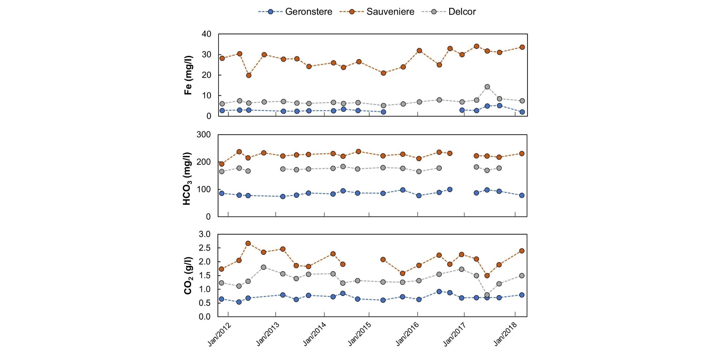
Figure 5. Evolution of HCO3-, Fe and CO2 concentrations in Geronstere, Sauveniere and Delcor pouhons in the Spa region (Fig. 2B) between 2011 and 2018. Internal data from Spadel.
4. Overview of models and theories
29Pouhons have been studied for a long time by several authors, but important unknowns are still remaining. Although there is some consensus on the infiltration and upward transport mechanisms, the source of CO2 at depth is still unresolved and will be discussed in the following sections. Isotopic analyses can be a key element to answer these questions. Besides water isotopes to determine age and origin of groundwater, one of the methods used to determine the origin of CO2 in groundwaters globally, and the main method used in the Belgian Ardenne, is C isotope analysis. Carbon-13 traces carbon sources and reactions for a multitude of interreacting organic and inorganic species (Clark & Fritz, 1997).
30Limited isotope data for the studied region were published by Defosse & Wery (1975), Langguth & Plum (1984), Wollast (1985), Smets & Wollast (1988), and Monjoie (1997). Most information available is on ratios of stable H (δ 2H/1H, or δ2H) and O (δ 18O/16O, or δ18O) isotopes of pouhon and rain samples, C isotopes (δ 13C/12C, or δ13C) and tritium (3H) content of pouhon samples, as summarised in Table 2 and presented in full in the Supplementary Material. These historical data are being presented and discussed with caution, considering the limitations of analytical methods at the time of the analyses. Such limitations are reflected e.g. in large errors.
Table 2. Summary of isotope data of CO2-rich waters in the Ardenne. Detailed data and references presented in the Supplementary Material online. TU for Tritium Units.
|
Sources |
δ18O range |
δ2H range |
TU range |
δ13C range |
δ34S range |
|
Stoumont region |
-8.32 to -7.89 |
-57.1 to -53.3 |
1.6 to 17.7 |
-7.76 to 0.80 |
- |
|
Spa region |
-8.04 to -7.79 |
-57.0 to -54.7 |
5.3 to 22.6 |
-7.2 to -3.8 |
+5.4 to +6.7 |
|
Malmedy region |
-8.62 to -8.10 |
-58.8 to -56.0 |
1.8 to 5.2 |
-4.74 to -2.70 |
+7.2 |
|
Bernister region |
-8.20 to -7.90 |
-58.0 to -57.4 |
10 to 17.3 |
-5.80 to -4.18 |
- |
31Moreover, the spatial correlation between water sources and major faults in the Ardenne was noted by various authors, but is still debated. Laurent (1987) and Graulich (1969) highlighted the occurrence of a network of major faults in the region, some of them apparently reactivated as recently as during the Quaternary. Graulich (1969) describes that a 250-metre deep coal mine gallery in Limburg (The Netherlands) intercepted a fault with as result a large inflow of thermal water (50 oC) with a high CO2 content, suggesting that this was acting as a main preferential pathway for groundwaters at depth. Monjoie (1995) noted that pouhons occur preferentially at the intersection of traces of N-S faults with NNE-SSW or NW-SE faults. Geukens (2007) argues that the majority of water sources in Spa can be interpreted as linked to the thrust fault corresponding to the southern border of the Theux Window. Those faults are presumed to be preferential pathways that enable CO2-rich waters to reach the surface (e.g. Monjoie, 1995). A commonly mentioned mechanism is that, after infiltrating through the bedrocks and acquiring the CO2 at depth, rapid ascent through faults or faulted zones would have to happen to allow the conservation of the CO2 concentration acquired at depth, and avoid the release of CO2 due to the pressure decrease (e.g. Monjoie, 1995).
4.1. Origin and estimated age of groundwaters
32Data obtained for H and O isotopes in water samples from the Ardenne (Table 2) are presented in Figure 6. The largest observed variation lies in the δ2H signature, mostly between -58 and -60‰ away from the Standard Mean Ocean Water (SMOW). Results of all water samples are close to the Global Meteoric Water Line (Fig. 6), indicating limited isotopic re-equilibration with the bedrocks. Shifts in δ2H between analysed rainwater and pouhon waters could indicate an isotopic exchange with gas species such as H2S, inducing an increase of δ2H and/or precipitation of hydrated minerals, combined with high temperature groundwater-rocks interactions, inducing an increase of δ18O. Nonetheless, the groundwater that will be later enriched in CO2 is thought to be from meteoric origin. However, it should be noted that one rain sample collected in Stoumont during the spring period presented the most negative δ2H signature around -65‰ vs. SMOW.
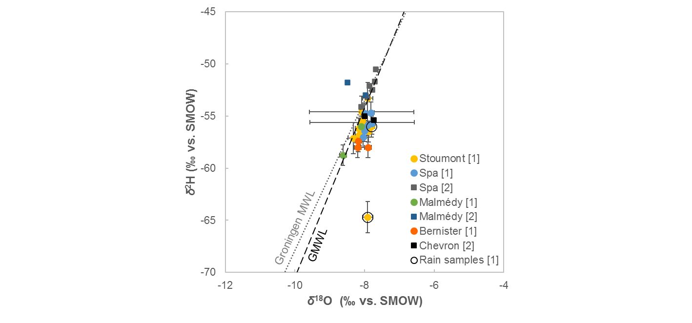
Figure 6. Available δ18O and δ2H data for CO2-rich waters in the Ardenne after [1] Monjoie (1997) and [2] Langguth & Plum (1984). Global Meteoric Water Line (GMWL) after Rozanski et al. (1993). Data for the local meteoric water line (Groningen) after IAEA/WMO (2019).
33For this aspect, a general and widely accepted hydrogeological conceptual model that most authors agree upon is then that meteoric water infiltrates through mostly horizontal Quaternary peat and/or colluvia, Cenozoic residual sands and Cretaceous residual clays on top of the High Fens plateau, and then penetrates the underlying altered Lower Palaeozoic quartzites and slates and percolating through fissures in the unaltered Lower Palaeozoic rocks, the waters meet the CO2 source at depth.
34Data for tritium dating were analysed considering the peak of tritium input to groundwater during testing periods of thermonuclear bombs, the most significant around 1952 and 1963. Although 3H values are variable (Table 2), most CO2-rich water sources present clear contribution of post-nuclear water input inferred by relatively high TU (Tritium Units). Dating of HCO3- and CO2 of the Pierre le Grand pouhon using the 14C method (Lannguth & Plum, 1984) yielded an age of ≤24,000 years. However, the authors emphasize large uncertainties in this estimate due to low 14C concentrations.
35Mixing processes are mentioned to explain co-existing presumably older groundwater with TU < 5 (Monjoie, 1997), and the discrepancy between 14C and tritium ages (Langguth & Plum, 1984). Mixing is also inferred from the variation of δ34S isotopic signature (Langguth & Plum, 1984).
4.2. Origin of CO2 in groundwaters
36The nature of the CO2 source at depth in the Ardenne is contentious. Several theories, some of them abandoned, have been proposed and discussed for over the decades. Most of them are supported or discarded based on the measured δ13C isotopic signature of groundwaters (Table 2). The hypotheses of the origin of CO2 and mineralisation processes are summarised as follows.
37Atmospheric origin. Given the meteoric origin of groundwaters in the Ardenne (Monjoie, 1995) and considering that atmospheric CO2 is in equilibrium with rainwater prior to infiltrating the ground, the concentration of CO2 (equivalent to the concentration of carbonic acid H2CO3) in rainwater is estimated at 0.53 mg/l. Even when we exclude here the bicarbonate equilibria, this estimated concentration is very small when compared to the typical CO2 contents observed in pouhon waters that range between 0.5 and 3.0 g/l (Table 1), therefore demonstrating atmospheric CO2 can only be a minor source of the CO2 in those groundwaters.
38Organic origin. The presence of extensive peatlands in the High Fens area in eastern Belgium was suggested as possible organic CO2 source for the groundwaters (Defosse & Wery, 1975). The decomposition of organic matter by bacterial activity in the first metres of soil produces CO2 that would lead to a concentration of 15.6 mg/l of H2CO3 in water. This value is too low to consider an organic source as the only origin of CO2 for groundwater.
39Furthermore, results obtained from C isotope analyses (Table 2) discard the possibility of CO2 origin by organic matter decomposition, for which values of ẟ13C are -18‰ and below (e.g. Hoefs, 2009). Moreover, except for the Spa area, peat makes a small proportion of the studied region.
40Dissolution and/or metamorphism of carbonate rocks. Dissolution of carbonate rocks by acidified groundwater that would solubilise bicarbonate and carbonate ions is currently one of the most accepted explanations for the origin of the CO2 in pouhon waters.
41Many authors suggest that a first source of rainwater acidification is from organic acids due to infiltration through superficial layers rich in organic matters (peat/colluvium) (Defosse & Wery, 1975; Laurent, 1987; Wollast & Wollast, 1987). Then, in the bedrock, oxidation of pyrite (FeS2), a common mineral in the local geology (Lamberty et al., 2016), forming sulphuric acid may also increase water acidity. This hypothesis could possibly explain high Fe concentrations in pouhon waters, but is not consistent with the low sulphate contents (<12 mg/l, Table 1) and would assume sufficiently strong oxidising conditions below the water table.
42Acidification of groundwater would then be sufficient to dissolve carbonate rocks. However, carbonate rocks are not common in the Stavelot-Venn Massif. Laurent (1987) mentions the presence of calcite and siderite in Cambrian and Ordovician dark slates. Carbonated nodules have also been observed in the basis of the Marteau Formation (Lamberty et al., 2016) that forms the discordance between Ordovician and Lower Devonian. However, it is unlikely that the dissolution of this finite stock of nodules would suffice to originate high quantities of CO2 over a prolonged period. The most often cited source of carbonates are therefore the Middle to Upper Devonian and Carboniferous limestones outcropping to the north of the Massif and which could possibly be found also at depth, being overthrusted by the older rocks of the Stavelot-Venn Massif (e.g. Fielitz, 1992). A third possible source, for the Malmedy area, is the Permian filling of the Malmedy Graben. The graben is filled by a conglomerate with locally a significant amount of Carboniferous carbonate pebbles and carbonate cement (Lamberty et al., 2017). However, the current level of erosion is probably already close to the roots of this graben, limiting the current depth and volume of its infill.
43Results obtained for δ13C in CO2 of pouhon samples (Table 2) show some variations between water sources, but mostly comprised within -8 and -2‰ δ13C, with a few samples yielding δ13C between -1.96 and 1‰ δ13C (Fig. 7). The range between -8 and -5‰ is found both in magmatic-derived CO2 (e.g. Deines, 1970; Cartigny et al., 1998; Hoefs, 2009) and bulk crustal / atmospheric carbon (e.g. Hoefs, 2009), and this overlap is represented in Figure 7. The isotopically heaviest sources of carbon are marine carbonates (δ13C between -4 and 4‰), which configure one of the main carbon reservoirs (Hoefs, 2009). The isotopic signature of some pouhon waters could possibly result from carbon sources from carbonate rocks, or a combination of CO2 from magmatic and bulk crustal origins.
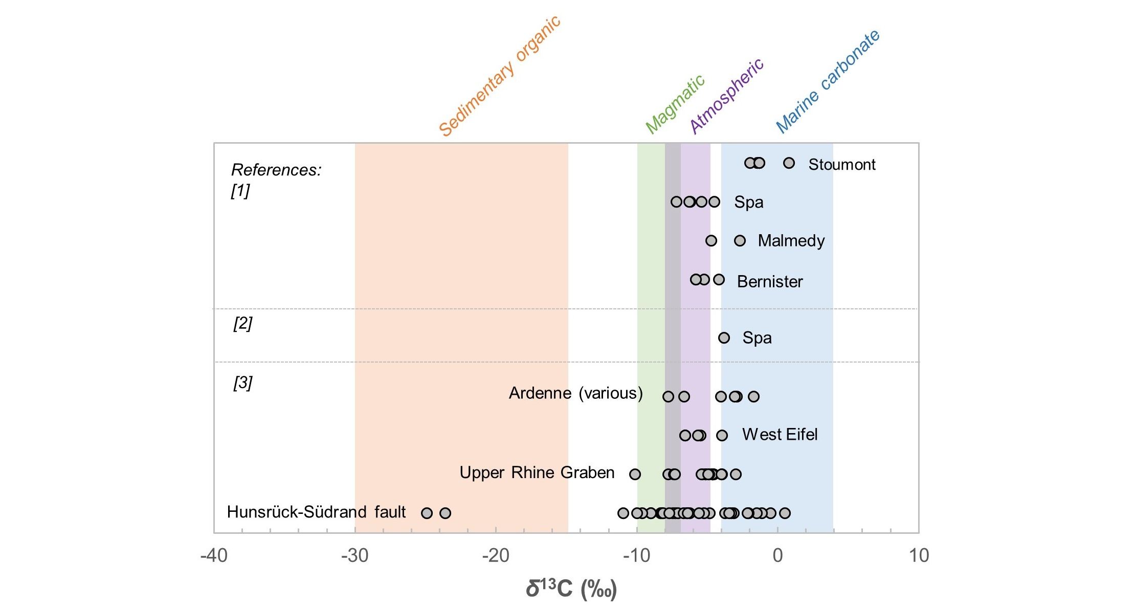
Figure 7. Available δ13C data for carbonated waters in the Ardenne (Belgium) and Eifel, Rhine Graben and Rhenish Massif (Germany) from [1] Monjoie (1997), [2] Langguth & Plum (1984) and [3] Griesshaber et al. (1992). Ranges of isotopic signatures for sedimentary organic and marine carbonate carbon (Hoefs, 2009), magmatic (mantle) CO2 (Deines, 1970) and atmospheric CO2 (Veizer, 2009) are also presented for comparison—note the overlap between mantle and atmospheric signatures. Error bars are smaller than symbols.
44Other possible source of CO2, proposed by Laurent (1987), are metamorphic reactions involving kaolinite (Al2Si2O5(OH)4), quartz (SiO2), rhodocrosite (MnCO3) and siderite (FeCO3) to generate spessartine (Mn3Al2Si3O12) or chloritoid (FeAl2SiO5) at estimated P-T conditions of 360–450 °C and 2 kbar. Minerals involved are often observed in the Cambrian and Ordovician rocks forming the Stavelot-Venn Massif (e.g. Schreyer et al., 1992; Theye et al., 1996). These reactions would then lead to the formation of CO2 at depth. Metamorphic reactions as source of CO2 were also mentioned by Wollast & Wollast (1987). Depending on the position within the Stavelot-Venn Massif, such conditions were reached during the Caledonian and Variscan metamorphic events and indeed resulted in the generation of CO2 rich fluids (Schroyen & Muchez, 2000). It is however doubtful that CO2 from those events would to-date still be available as fluids, other than trapped in fluid inclusions.
45Monjoie (1995) concluded that the positive to weakly negative δ13C of CO2 in groundwaters sampled in Stoumont exclude the hypotheses of magmatic or organic CO2 (Fig. 7) and can only be explained by dissolution of carbonate rocks at depth as described above. However, most samples from other areas have a range that may represent partial magmatic origin, or bulk crustal / atmospheric origin (Fig. 7). Therefore, identifying a source based solely on carbon isotopes is not possible.
46Magmatic origin. The relative proximity of the Stavelot-Venn Massif to the volcanic area of Eifel has driven several authors to suggest a volcanic or juvenile origin of the CO2 (Van Beneden, 1947; Wollast & Wollast, 1987; Monjoie, 1995, 1997), although little geochemical evidence was provided. Defosse & Wery (1975) are the main authors arguing against a volcanic origin for CO2. Reasons mentioned include the lack of a negative trend in measured CO2 concentrations over time, which should be observed since these authors considered the Eifel volcanic activity to be extinct and CO2 reserves stored in host rocks would be slowly and irreversibly decreased, and the lack of CO2-rich water occurrences in other areas close to the extinct volcanoes such as in Saint-Vith or Schöneberg areas.
47However, recently the Eifel activity has been shown as not extinct, with ongoing migration of magma or magmatic fluids (e.g. Ritter et al., 2001; Schmincke, 2007; Hensch et al., 2019) and therefore a magmatic origin for the CO2 is probable. Furthermore, a decrease in CO2 concentrations in groundwaters should first of all be observable in the Eifel area itself, as being closest to the CO2 source. Griesshaber et al. (1992) reported results for C and He isotope analyses for the Rhenish Massif, including Fays, Spa, Chevron and Harre in the Ardenne, and the Hunsrück-Südrand Fault, besides various locations in the Rhine Graben and Black Forest (Fig. 7). The percentage of mantle He in total dissolved He varies between sources: around 14% for Spa, between 30 and 35% for Chevron, and around 12% for Harre; these should, however, be considered as minimum values, since the authors consider the mantle-derived R/Ra (3He/4He of sample normalised to that of the atmosphere) for the Eifel area similar to MORB values, whereas in reality this was demonstrated to be lower (i.e. R/Ra around 5 according to Bräuer et al., 2013).
48The same authors favoured the hypothesis of a mixed origin from mantle and crustal C sources for the CO2 in the Ardennian pouhons, noticing separate trends in δ13C and percentage of mantle He (Fig. 8): a) magmatic He and C and crustal, radiogenic He mixed with organic-derived C, and b) magmatic He and C to radiogenic He mixed with carbonate-derived carbon. The second trend is based on a small number of samples enriched in 13C, implying the presence of an additional component of crustal carbon to these groundwaters. Pouhons and springs along the Hunsrück-Südrand Fault to the southeast are isotopically indistinguishable and show similar mixing trends (Fig. 8). Most samples from the Eifel area show a stronger magmatic component (over 35% mantle He).
49A magmatic origin for the CO2 is in agreement with interpretations by other authors for CO2-rich (Ca-Mg-HCO3 type) waters in the western part of the Rhenish Massif (e.g. Plum, 1989; May et al., 1996).
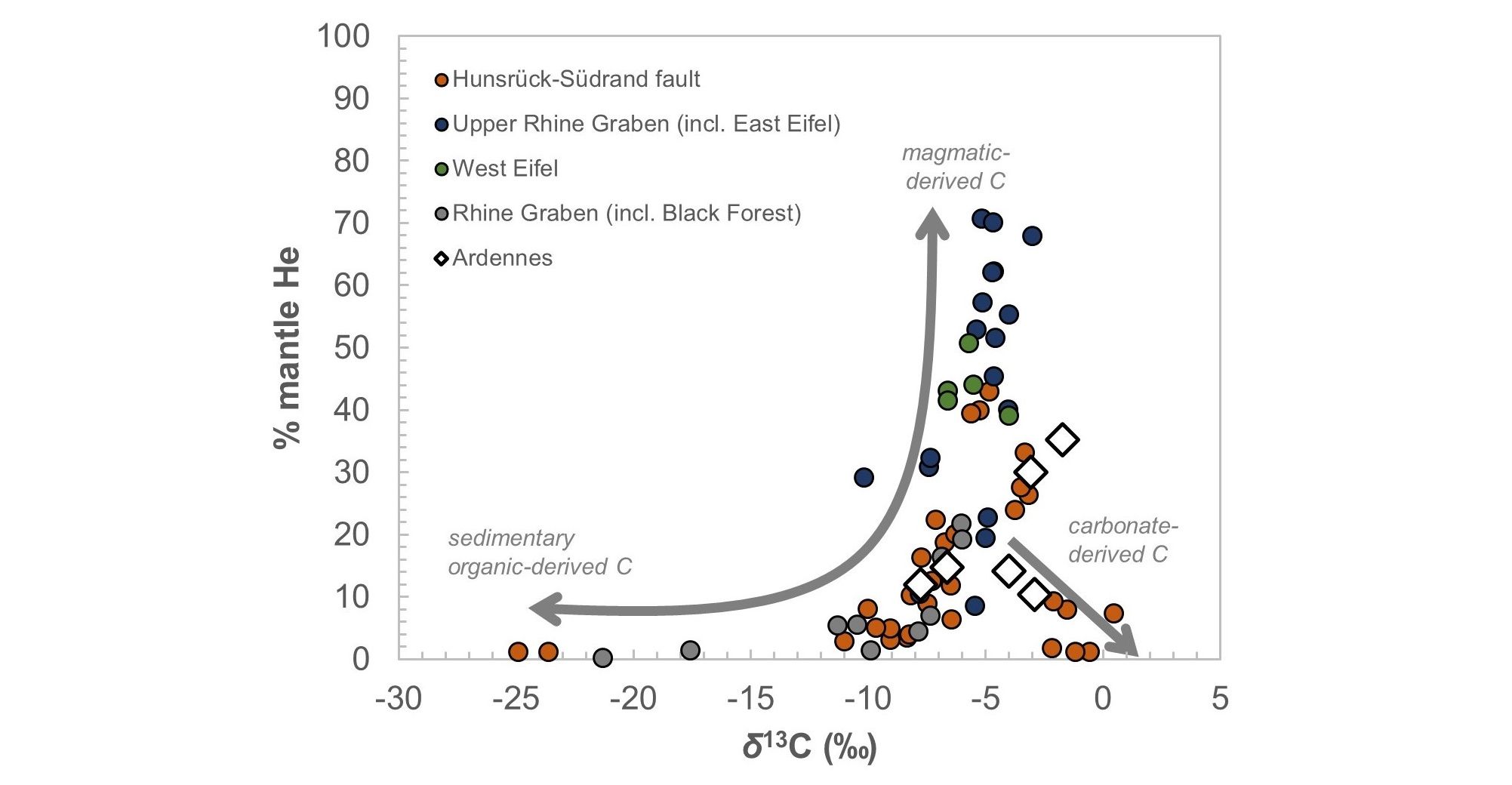
Figure 8. Variation of percentage mantle He and δ13C values for CO2-rich groundwaters in Belgium (Ardenne) and Germany (other data) after Griesshaber et al. (1992). Error bars are smaller than symbols. For location of the Hunsrück-Südrand Fault and Eifel region refer to Fig. 1.
4.3. The crustal component: occurrence of carbonate rocks in the Ardenne
50Based on isotope data discussed earlier, it is believed that the CO2 in the pouhons originates at least partially from dissolution of carbonate rocks, which in the Ardenne are predominantly represented by Dinantian and Middle Devonian carbonates. If this model is correct, it therefore implies that carbonate rocks, part of this sequence, occur at depth within the complex fold-and-thrust belt of the Variscan front in the Ardenne.
51The structural evolution of the Variscan front zone in Belgium and western Germany has been widely studied over the years (e.g. Le Gall, 1992; von Winterfeld, 1994; Hance et al., 1999, Vanbrabant et al., 1999, 2002). The interpretation of the deformation history can be separated in two contrasting models: in-sequence forward thrust propagation and out-of-sequence thrust propagation. The first is a standard model of thrust systems formed progressively and in order in one direction, based on the understanding of sequences dominated by competent rocks such as the Appalachians, while the second is characterised by unpredictable trajectories in heterogeneous sequences with a lower proportion of competent rocks (McClay, 1991; Hance et al., 1999).
52Different interpretations of deformation history in the region have led to distinct interpretations of subsurface geology, as shown by the comparison between geological cross sections (Vanbrabant, 2001; Fig. 9). Of special interest to the discussion around the possible CO2 source of the pouhons is the extension of carbonate-containing Dinantian and Middle Devonian sequences at depth to the south of the Theux Window in the Stavelot-Venn Massif. Geological interpretations based on out-of-sequence thrusting restrict these sequences to the north of the Massif, particularly in its northwestern part (see different interpretations for section B). Alternatively, interpretations based on in-sequence thrusting allow for carbonates at depths between 2 and 6 km over a larger extension below the Stavelot-Venn Massif (Fig. 9).
53It is therefore possible to tie the crustal C component identified in the CO2 from the pouhons to the dissolution of carbonates occurring below the Stavelot-Venn Massif, especially when considering geotectonic evolution through in-sequence thrusting in the Ardenne. In this case, it is assumed groundwater would currently need to circulate to at least 2 km deep to reach the carbonates. This seems to require a deep network of open fractures or faults facilitating water infiltration and subsequent upward transport.
54However, if groundwaters ascend rapidly in order to preserve their high CO2 content, as assumed in previous studies (e.g. Monjoie, 1995), this does not seem in line with the overall low temperatures (around 10 °C) of the pouhon waters and absence of thermal waters in the region. Moreover, given the unaltered meteoric δ18O of pouhons, it is inferred that there is no isotope exchange between infiltrating meteoric water and bedrocks; water-rock reactions, if occurring, are at low temperatures, below 200 oC (Karolytė et al., 2017). Infiltration of meteoric water must therefore be limited to 6 km depth. Additionally, the concentration of Ca ions is relatively low in pouhon waters, mostly between 10–55 mg/l (Table 1). If carbonate rocks have dissolved to contribute for a part of the dissolved CO2, it is then assumed that Ca ions precipitated prior to water resurfacing.
55Given the above, the CO2-rich waters in the Ardenne are most likely resulting from upward CO2 flow from deeper levels reaching local flow systems with short underground residence times, similarly to what is observed in similar water types in the Eifel region (e.g. May et al., 1996). This discards the premise that waters need to circulate as deep as where carbonate rocks may occur to acquire the CO2.
Figure 9. Comparison between geological cross sections demonstrating different interpretations of the geotectonic evolution of eastern Belgium (from Vanbrabant, 2001). Carbonate rocks occur in Dinantian and Middle Devonian sequences. Syn. = Synclinorium; Ag.-As. Thr. = Aguesse-Asse Thrust. Location of cross sections as indicated in Fig. 1.
4.4. The mantle component: possible links with Eifel, Germany
56The carbon isotopic signature of the pouhons cannot be explained solely by CO2 originated from carbonate rocks, since a magmatic component was demonstrated (Griesshaber et al., 1992). As mentioned previously, CO2-rich waters are also common in the neighbouring Eifel area in Germany (Fig. 10). Evidences for mantle upwelling under central Europe include thinning of the lithosphere in regions of Cenozoic volcanism (Babuska & Plomerova, 1992), the identification of a low seismic velocity structure 660 to 2000 km deep on tomographic images (Goes et al., 1999), among others. Mantle plumes possibly fed by this main upwelling system have been identified in the Eifel area (Ritter et al., 2001; Kreemer et al., 2020), and in other areas such as the Massif Central (France) (Granet et al., 1995). The existence of a plume is, however, not a consensus in the scientific community (e.g. Meier et al., 2016).
Figure 10. Occurrence of naturally carbonated springs in Belgium and Germany. The shaded red circle shows the presumed extension of the Eifel plume (>50 km depth) at the surface (after Bräuer et al., 2013). Areas of occurrence of CO2-rich springs in Belgium according to this study, and in Germany after Griesshaber et al. (1992), Bräuer et al. (2013) and May et al. (1996). Full geological setting in Fig. 1.
57Contribution from the mantle in degassing locations (springs and mofettes) is well established in the area (e.g. Aeschbach-Hertig et al., 1996; Schmincke, 2007). Most studies are based on He isotopes given the markedly different isotopic signatures between their three main reservoirs, atmosphere, Earth’s crust and mantle (White, 2015).
58Regional studies were carried out by Bräuer et al. (2004, 2013, 2017), obtaining δ13C and 3He/4He ratios for CO2-rich springs and mofettes in Cenozoic volcanic areas in the Eifel, as well as around the Massif Central and the Eger Rift in Czech Republic. Isotopic signatures in gas samples of the three areas overlap the characteristic range of the subcontinental lithospheric mantle and the authors suggest that CO2 upflows from the degassing magmatic reservoirs through deep faults (Bräuer et al., 2013). According to the same authors, these magmatic reservoirs presumably fed the intra-continental Eifel volcanism in the past.
59The contribution from mantle CO2 identified in the Belgian pouhons (Griesshaber et al., 1992) could possibly be linked to the supposed extension of the Eifel plume area (after Bräuer et al., 2013), which is occurring at depths between 50 and 410 km (Ritter et al., 2001; Fig. 10). The mantle component is presumably dominantly gaseous, since coupled H-O isotopic signature for pouhons does not show large deviations from the GMWL towards magmatic fluid signature. This implies that the contribution of CO2 from the mantle either a) diffuses from the plume at 50 km depth or deeper and is transported upwards to the depth reached by percolating groundwater of meteoric origin, and/or b) diffuses and is transported upwards from shallower magmatic reservoirs still to be identified in the lower crust below the Ardenne. Based on CO2 flux density in the Eifel, it is likely that both mechanisms happen simultaneously (May, 2002).
5. Towards an integrated model
60A mixed crustal-mantle origin for the CO2 in the Ardennian pouhons has been suggested by previous authors. This is also considered by us as the most plausible at present. In this respect, the processes that form CO2-rich pouhon waters are schematically described and summarised in Figure 11. Supporting evidence compiled and discussed in the present study can be summarised as follows:
61- Meteoric water infiltrates in the areas of higher altitude and travels through geological layers with relatively low rock-water interactions until around 400 metres depth (‘demineralisation limit’ of Monjoie, 1992), and with different bedrock lithologies beyond that. There is no isotope exchange between infiltrating meteoric water and bedrocks along shallower and deeper pathways, since the 2H and 18O isotopic signature is largely unchanged (path D in Fig. 11).
62- Infiltrating deeper, water acquires a high CO2 content. This is thought to have two main contributing components:
-
The crustal component of the CO2 could be generated through dissolution of carbonate rocks at depth possibly enhanced by water acidification by pyrite oxidation.
-
The magmatic component of the CO2 could be associated with the degassing of the Eifel plume, with the top located at 50 km depth, or from an unknown shallower magmatic reservoir.
63- CO2 originating from dissolution of carbonate rocks implies that water circulates to at least 2 km depth, based on the assumed possible location of carbonate rocks within Dinantian and Middle Devonian sequences according to the structural cross sections of the Stavelot-Venn Massif that assume in-sequence thrusting (Fig. 9). Structural models based on out-of-sequence thrusting are not able to explain the occurrence of carbonate rocks under the Stavelot-Venn Massif. Deeper circulation is unlikely, given the cold temperature of the pouhon waters when reaching the surface.
64- Most likely, the meteoric water does not infiltrate as deep, which would be in line with relatively short estimated residence times (up to 60 years) and low temperatures of pouhons. This implies that magmatic CO2 could be transported upwards to meet infiltrating groundwaters at shallower depths. The presence of mofettes in the region, although much rarer than pouhons, could be evidence of such upward transport of CO2. When the magmatic fluid along its path would encounter carbonate rocks, partial to full isotopic exchange would explain the mixed magmatic-carbonate signature.
Figure 11. Schematic cross section in the Spa region. Uppermost part modified from Goemaere et al. (2016) and Monjoie (1995). Possible deep circulation (A) and shallow circulation (B) paths for pouhon waters are represented. C and D represent possible water circulation paths for Barisart and Reine waters, respectively. Presence of carbonate rocks at depth requires in-sequence Variscan thrusting.
6. Conclusions
65Iron-rich cold CO2-rich mineral water springs called pouhons occur in East Belgium. They represent an opportunity to investigate and understand geological processes involving CO2 in the subsurface. Although for over a century various studies have focussed on these occurrences and models for their origin, there have been no recent attempts to integrate different models and data available. In this study, we have compiled physico-chemical parameters and isotopic compositions of Belgian pouhons, reviewed the possible sources of CO2 and processes that may lead to formation of CO2-rich waters.
66Most pouhon waters are of the calcium bicarbonate type (~310 mg/l HCO3- on average), with Fe (~15 mg/l), Ca (~43 mg/l on average), Mg (~27 mg/l) and Na (29 mg/l). The pouhons from the Stoumont region, occurring where Devonian bedrocks outcrop, are geochemically distinguishable from the pouhons from the Spa region, occurring in the area where Cambrian and Ordovician bedrocks outcrop. While the Spa groundwaters have no dominant cation type, the Stoumont groundwaters vary between dominant Ca, Mg or Na+K.
67Based on previous studies, a primarily meteoric origin of the pouhon waters is evidenced by 2H and 18O isotopic signature with little deviation from the GMWL. The δ13C ratios for different sources are between +0.8 and -7.76‰. Signatures of the pouhon waters overlap with C sourced from carbonate rocks (δ13C between -4 and 4‰) and mantle C (δ13C between -8 and around -5‰). Moreover, the percentage of mantle He in total dissolved He varies between sources, with minimum estimates of around 14% for Spa, between 30 and 35% for Chevron, and around 12% for Harre. This suggests that CO2 in pouhons results from a combination of CO2 from magmatic and crustal origins.
68Carbonate rocks in the Ardenne that might represent the crustal component in CO2 could be represented by Dinantian and Middle Devonian carbonates. These rocks possibly occur at depths of at least 2 km, based on in-sequence geological cross sections of the Stavelot-Venn Massif. Liberation of CO2 from these rocks could be achieved through dissolution by acidified water. However, this is in contradiction with the more generally accepted out-of-sequence thrust models.
69The magmatic component in dissolved CO2 could be associated with the degassing of the Eifel plume, with top located at depths over 50 km, or from an unknown shallower magmatic reservoir. The magmatic fluid can migrate to shallower levels, changing its isotopic composition when encountering carbonate rocks, before mixing with groundwater. Deeper groundwater circulation is less likely because elevated temperatures would result in isotopic exchange and deviation from a meteoric isotopic signature.
70The upward transport of CO2-rich water is thought to be facilitated by pathways formed by faults in the region. Overall low temperatures of the pouhons (around 10 °C) refute the generally accepted idea that the water ascent is rapid. Water circulation restricted to shallower depths is in line with estimated residence times of less than 60 years. This shallow circulation would imply that magmatic CO2 is transported upwards to meet groundwaters at depths that may be less than a few km. The occurrence of mofettes evidences such transport is happening.
71Although this only partly solves the precise origin of the CO2 in pouhon waters, we consider this review study provides a much-needed base for future investigations bringing together previously unrelated data and interpretations. Moreover, our model is a step forward from previous studies and contributes to the understanding of the complex subsurface cycle that involve water infiltration, CO2 assimilation and water resurfacing happening in east Belgium. Future work aims to provide new results on the isotope geochemistry of pouhon waters to determine the origin of CO2 with greater detail.
7. Acknowledgements
72The authors thank Franz May and one anonymous reviewer for the suggestions that improved an earlier version of this manuscript, and Vanessa Heyvaert for the editorial handling. The authors would like to thank: Spadel for giving access to data; Yves Vanbrabant for providing geological cross sections; Jean-Marc Marion for sharing his knowledge about the geological setting of the area.
73This work is part of two research projects: GeoConnect³d of GeoERA that has received funding by the European Union’s Horizon 2020 research and innovation programme under grant agreement number 731166, and ROSEAU project, as part of the Walloon program «Doctorat en Entreprise», co-funded by the SPW Région Wallonne of Belgium and the company Bru-Chevron S.A. (Spadel group), under grant number 7984.
8. References
74Aeschbach-Hertig, W., Kipfer, R., Hofer, M., Imboden, D.M., Wieler, R., Signer, P., 1996. Quantification of gas fluxes from the subcontinental mantle: the example of Laacher See, a maar lake in Germany. Geochimica et Cosmochimica Acta, 60, 31–41. https://doi.org/10.1016/0016-7037(95)00370-3
75Asselberghs, E., 1946. L'Eodévonien de l'Ardenne et des régions voisines. Mémoire de l'Institut géologique de l'Université de Louvain, 14, 1–598.
76Babuska, V. & Plomerova, J., 1992. The lithosphere in central Europe - seismological and petrological aspects. Tectonophysics, 207, 141–164. https://doi.org/10.1016/0040-1951(92)90475-L
77Belanger, I., Delaby, S., Delcambre, B., Ghysel, P., Hennebert, M., Laloux, M., Marion, J.-M., Mottequin, B. & Pingot, J.-L., 2012. Redéfinition des unités structurales du front varisque utilisées dans le cadre de la nouvelle Carte géologique de Wallonie (Belgique). Geologica Belgica, 15, 169–175.
78Bickle, M. & Kampman, N., 2013. Lessons in carbon storage from geological analogues. Geology, 41, 525–526. https://doi.org/10.1130/focus0420132.1
79Bräuer, K., Kämpf, H., Niedermann, S., Strauch, G. & Weise, S.M., 2004. Evidence for a nitrogen flux directly derived from the European subcontinental mantle in the western Eger Rift, central Europe. Geochimica et Cosmochimica Acta, 68, 4935–4947. https://doi.org/10.1016/j.gca.2004.05.032
80Bräuer, K., Kämpf, H., Niedermann, S. & Strauch, G., 2013. Indications for the existence of different magmatic reservoirs beneath the Eifel area (Germany): a multi-isotope (C, N, He, Ne, Ar) approach. Chemical Geology, 356, 193–208. https://doi.org/10.1016/j.chemgeo.2013.08.013
81Bräuer, K., Kämpf, H., Niedermann, S. & Wetzel, H.-U., 2017. Regional distribution pattern of carbon and helium isotopes from different volcanic fields in the French Massif Central: Evidence for active mantle degassing and water transport. Chemical Geology, 469, 4–18. https://doi.org/10.1016/j.chemgeo.2017.04.004
82Bultynck, P. & Dejonghe, L., 2001. Devonian lithostratigraphic units (Belgium). Geologica Belgica, 4, 39–69. https://doi.org/10.20341/gb.2014.043
83Bultynck, P., Coen-Aubert, M. & Godefroid, J., 2000. Summary of the state of correlation in the Devonian of the Ardennes (Belgium-NE France) resulting from the decisions of the SDS. Courier Forschungsinstitut Senckenberg, 225, 91–114.
84Burnside, N.M., Shipton, Z.K., Dockrill, B. & Ellam, R.M, 2013. Man-made versus natural CO2 leakage: a 400 k.y. history of an analogue for engineered geological storage of CO2. Geology, 41, 471–474. https://doi.org/10.1130/G33738.1
85Cartigny, P., Harris, J.W., Phillips, D., Girard, M. & Javoy, M., 1998. Subduction-related diamonds? - The evidence for a mantle-derived origin from coupled δ13C–δ15N determinations. Chemical Geology, 147, 147–159. https://doi.org/10.1016/S0009-2541(97)00178-2
86Cartwright, I., Weaver, T., Tweed, S., Ahearne, D., Cooper, M., Czapnik, K. & Tranter, J., 2002. Stable isotope geochemistry of cold CO2 -bearing mineral spring waters, Daylesford, Victoria, Australia: sources of gas and water and links with waning volcanism. Chemical Geology, 185, 71–91. https://doi.org/10.1016/S0009-2541(01)00397-7
87Clark, I.D. & Fritz, P., 1997. Environmental Isotopes in Hydrogeology. Lewis Publishers, New York, 328 p.
88Corin, F., 1965. Atlas des roches éruptives de Belgique. Mémoires du Service Géologique de Belgique, 4, 190 p.
89Dassargues, A., 2018. Hydrogeology: groundwater science and engineering. Taylor & Francis CRC press, Boca Raton, 472 p. https://doi.org/10.1201/9780429470660
90de Béthune, P., 1954. Carte géologique de Belgique (échelle 1/500.000). Atlas de Belgique, planche 8. Académie royale de Belgique, Bruxelles.
91Debbaut, V., Cajot, O., Ruthy, I., Dassargues, A., Hanson, A. & M. Bouezmarni, 2014. Aquifères de l'Ardenne. In Dassargues, A. & Walraevens, K. (eds), Watervoerende lagen & grondwater in Belgïe – Aquifères & eaux souterraines en Belgique. Academia Press, Gent, 299–314.
92Declercq, P.Y. & Dejonghe, L., 2010. OneGeology-Europe, 1:250,000. Internal database of the Geological Survey of Belgium.
93Defosse, C. & Wery, A., 1975. Recherche sur les pouhons des Ardennes Liégeoises. Centre belge d’Etude et de Documentation des Eaux, 375, 1–7.
94Deines, P., 1970. The carbon and oxygen isotopic composition of carbonates from the Oka carbonatite complex, Quebec, Canada. Geochimica et Cosmochimica Acta, 34, 1199–1225. https://doi.org/10.1016/0016-7037(70)90058-X
95Fielitz, W., 1992. Variscan transpressive inversion in the northwestern central Rhenohercynian belt of western Germany. Journal of Structural Geology, 14, 547–563. https://doi.org/10.1016/0191-8141(92)90156-Q
96Fielitz, W. & Mansy, J.L., 1999. Pre- and synorogenic burial metamorphism in the Ardenne and neighbouring areas (Rhenohercynian zone, central European Variscides). Tectonophysics, 309, 227–256. https://doi.org/10.1016/S0040-1951(99)00141-9
97Fourmarier, P., 1931. Les plissements calédoniens et les plissements hercyniens en Belgique. Annales de la Société géologique de Belgique, 54, B364–B384.
98Geukens, F., 1957. Les failles bordières du Graben de Malmedy. Bulletin de la Société belge de Géologie, de Paléontologie et d’Hydrologie, 66, 71–81.
99Geukens, F., 1989. Observations structurales entre La Reid et Surister (Massif de Theux). Annales de la Société géologique de Belgique, 112, 191–196.
100Geukens F., 1995. “Strike slip deformation” des deux côtés du graben de Malmédy. Annales de la Société géologique de Belgique, 118, 139–146.
101Geukens, F., 1999. Notes accompagnant une révision de la carte structurale du Massif de Stavelot. Aardkundige Mededelingen, 9, 183–190.
102Geukens, F., 2007. Les sources de Spa et la Fenêtre de Theux. Geologica Belgica, 10, 127–130.
103Geukens, F., 2008. Carte géologique de Wallonie : Notice explicative de la carte géologique Bra – Lierneux 55/3-4. Service Public de Wallonie, Direction générale opérationnelle Agriculture, Ressources naturelles et Environnement, Namur, 38 p.
104Goemaere, E., Demarque, S., Dreesen, R. & Declercq, P.-Y., 2016. The geological and cultural heritage of the Caledonian Stavelot-Venn Massif, Belgium. Geoheritage, 8, 211–233. https://doi.org/10.1007/s12371-015-0155-y
105Goes, S., Spakman, W. & Bijwaard, H., 1999. A lower mantle source for Central European volcanism. Science, 286, 1928–1931. https://doi.org/10.1126/science.286.5446.1928
106Granet, M., Wilson, M. & Achauer, U., 1995. Imaging a mantle plume beneath the French Massif Central. Earth and Planetary Science Letters, 136, 281–296. https://doi.org/10.1016/0012-821X(95)00174-B
107Graulich, J.-M., 1969. Eaux minérales et thermales de Belgique. In Kačura, G. (ed.), XXIII International Geological Congress, Proceedings of Symposium II: Mineral and Thermal Waters of the World, A-Europe. Academia, Prague, Vol. 18, 9–15.
108Griesshaber, E., O’Nions, R.K. & Oxburgh, E.R., 1992. Helium and carbon isotope systematics in crustal fluids from the Eifel, the Rhine Graben and Black Forest, F.R.G. Chemical Geology, 99, 213–235. https://doi.org/10.1016/0009-2541(92)90178-8
109Hance, L., Dejonghe, L., Ghysel, P., Laloux, M. & Mansy, J.-L., 1999. Influence of heterogeneous lithostructural layering on orogenic deformation in the Variscan Front Zone (eastern Belgium). Tectonophysics, 309, 161–177. https://doi.org/10.1016/S0040-1951(99)00137-7
110Harris, C., Stock, W.D. & Lanham, J. 1997. Stable isotope constraints on the origin of CO2 gas exhalations at Bongwan, Natal. South African Journal of Geology, 100, 261–266.
111Hensch, M., Dahm, T., Ritter, J., Heimann, S., Schmidt, B., Stange, S. & Lehmann, K., 2019. Deep low-frequency earthquakes reveal ongoing magmatic recharge beneath Laacher See Volcano (Eifel, Germany). Geophysical Journal International, 216, 2025–2036. https://doi.org/10.1093/gji/ggy532
112Herbosch, A., Liégeois, J.P., Gärtner, A., Hofmann, M. & Linnemann, U., 2020. The Stavelot-Venn Massif (Ardenne, Belgium), a rift shoulder basin ripped off the West African craton: Cartography, stratigraphy, sedimentology, new U-Pb on zircon ages, geochemistry and Nd isotopes evidence. Earth-Science Reviews, 203, 103142. https://doi.org/10.1016/j.earscirev.2020.103142
113Hoefs, J., 2009. Stable Isotope Geochemistry, 6th ed. Springer, Heidelberg, 285 p. https://doi.org/10.1007/978-3-540-70708-0
114Hollmann, G. & Walter, R., 1995. The Variscan deformation front between Stavelot-Venn Anticline and Brabant Massif – a balanced geological cross section along the Liège-Theux traverse. Neues Jahrbuch für Geologie und Paläontologie Monatshefte, 1995/2, 92–104. https://doi.org/10.1127/njgpm/1995/1995/92
115IAEA/WMO, 2019. Global Network of Isotopes in Precipitation. The GNIP Database. https://www.iaea.org/services/networks/gnip, accessed 03/12/2019.
116IPCC, 2005. Carbon Dioxide Capture and Storage. Cambridge University Press, Cambridge, 442 p.
117IPCC, 2014. Climate Change 2014, Mitigation of climate change – Summary for policymakers and technical summary. In Edenhofer, O., Pichs-Madruga, R., Sokona, Y., Farahani, E., Kadner, S., Seyboth, K., Adler, A., Baum, I., Brunner, S., Eickemeier, P., Kriemann, B., Savolainen, J., Schlömer, S., von Stechow, C., Zwickel, T. & Minx, J.C. (eds), Climate Change 2014: Mitigation of Climate Change. Contribution of Working Group III to the Fifth Assessment Report of the Intergovernmental Panel on Climate Change. Cambridge University Press, Cambridge, 1–107.
118Karol, P.J., 2019. The Legacy of Carbon Dioxide: Past and Present Impacts. CRC Press, Boca Raton, 253 p. https://doi.org/10.1201/9780429200649
119Karolytė, R., Johnson, G., Serno, S. & Gilfillan, S.M.V., 2017. The influence of water-rock reactions and O isotope exchange with CO2 on water stable isotope composition of CO2 springs in SE Australia. Energy Procedia, 114, 3832–3839. https://doi.org/10.1016/j.egypro.2017.03.1515
120Kreemer, C., Blewitt, G. & Davis, P.M., 2020. Geodetic evidence for a buoyant mantle plume beneath the Eifel volcanic area, NW Europe. Geophysical Journal International, 222, 1316–1332. https://doi.org/10.1093/gji/ggaa227
121Lamberty, P., Geukens, F., Marion, J.-M. & Mottequin, B., 2016. [Carte géologique de Wallonie :] Notice explicative de la carte géologique Harzé – La Gleize 49/7-8. ULG/Géologie/Eddy Lab & IRSNB, Liège, 86 p.
122Lamberty, P., Geukens, F. & Marion, J.-M., 2017. [Carte géologique de Wallonie :] Notice explicative de la carte géologique Stavelot – Malmédy 50/5-6. ULG/Géologie/Eddy Lab, Liège, 86 p.
123Langguth, H.R. & Plum, H., 1984. Untersuchung der Mineral- und Thermalquellen der Eifel auf geothermische Indikationen. Technologische Forschung und Entwicklung - Nichtnukleare Energietechnik, Lehr- und Forschungsgebiet für Hydrogeologie der RWTH Aachen, Bundesministerium für Forschung und Technologie, Bonn, Forschungsbericht, BMFT-FBT 84-019, 196 p.
124Laurent, E., 1987. Contributions à l’étude de la genèse et de la protection des eaux minérales du Massif de Stavelot. Unpublished Ph.D. Thesis, Université Libre de Bruxelles, Faculté des Sciences Appliquées, Bruxelles, 365 p.
125Le Gall, B., 1992. The deep structure of the Ardennes Variscan thrust belt from structural and ECORS seismic data. Journal of Structural Geology, 14, 531–546. https://doi.org/10.1016/0191-8141(92)90155-P
126Liégeois, P.G., 1929. Les sources minérales gazeuses et ferrugineuses de l’Ardenne belge. Annales de l’Institut d’Hydrologie et de Climatologie, 6, 34 p.
127Liégeois, P.G., 1931. L’anhydride carbonique naturel, les failles et les sondages. Bulletin de la Société belge de Géologie, de Paléontologie et d’Hydrologie , 41, 36–41.
128May, F., 2002. Säuerlinge der Vulkaneifel und der Südeifel. Mainzer geowissenschaftliche Mitteilungen, 31, 7–57.
129May, F., 2005. Alteration of wall rocks by CO2-rich water ascending in fault zones: natural analogues for reactions induced by CO2 migrating along faults in siliciclastic reservoir and cap rocks. Oil & Gas Science and Technology, 60, 19–32. https://doi.org/10.2516/ogst:2005003
130May, F., Hoernes, S. & Neugebauer, H.J., 1996. Genesis and distribution of mineral waters as a consequence of recent lithospheric dynamics: the Rhenish Massif, Central Europe. Geologische Rundschau, 85, 782–799. https://doi.org/10.1007/s005310050112
131McClay, K.R., 1991. Glossary of thrust tectonics terms. In McClay, K.R. (ed.), Thrust Tectonics. Chapman & Hall, London, 419–433.
132Meier, T., Soomro, R.A., Viereck, L., Lebedev, S., Behrmann, J.H., Weidle, C., Cristiano, L. & Hanemann, R., 2016. Mesozoic and Cenozoic evolution of the Central European lithosphere. Tectonophysics, 692, 58–73. https://doi.org/10.1016/j.tecto.2016.09.016
133Meschede, M., 2018. Deutschland im späten Paläozoikum. In Geologie Deutschlands. 2nd ed. Springer Spektrum, Berlin, 61–101. https://doi.org/10.1007/978-3-662-45298-1_10
134Michot, P., 1980. Le segment tectogénique calédonien belge. Mémoires de l’Académie Royale de Belgique, classe des Sciences, Collection in 8°, 2ème série, 43, 61 p.
135Monjoie, A., 1992. Les eaux souterraines de la région de Spa. Unpublished internal Spadel report, Laboratoire de Géologie de l’Ingénieur, d’Hydrogéologie et de Prospection Géophysique, Université de Liège.
136Monjoie, A., 1995. Les eaux carbo-gazeuses et minéralisées du sud-est de la Belgique. La Houille Blanche, 1995/2-3, 100–105. https://doi.org/10.1051/lhb/1995022
137Monjoie, A., 1997. Etude des eaux carbogazeuses du sud-est de la Belgique. Grant Spadel internal report 971, 51 p.
138Papier, S., Baele, J.-M., Debouge, W., De Jong, J., Mattielli, N. & Gillan, D., 2016. Iron isotope fractionation in a Modern iron-oxidizing bacterial mat. In Proceedings of the 5th International Geologica Belgica Congress. University of Mons, Mons, p. 162. https://doi.org/10.20341/gbcp.vol2
139Piper, A.M., 1944. A graphic procedure in the geochemical interpretation of water-analyses. Eos, Transactions American Geophysical Union, 25, 914–928. https://doi.org/10.1029/TR025i006p00914
140Pirson, S., Spagna, P., Baele, J.-M., Damblon, F., Gerrienne, P., Vanbrabant, Y. & Yans, J., 2008. An overview of the geology of Belgium. Memoirs of the Geological Survey of Belgium, 55, 5–25.
141Plum, H., 1989. Genetische Klassifikation und geochemische Interpretation der Mineral- und Thermalwässer der Eifel und Ardennen. Mitteilungen zur Ingenieurgeologie und Hydrogeologie, 34, 1–170.
142Ritter, J.R.R., Jordan, M., Christensen, U.R. & Achauer, U., 2001. A mantle plume below the Eifel volcanic fields, Germany. Earth and Planetary Science Letters, 186, 7–14. https://doi.org/10.1016/S0012-821X(01)00226-6
143Rozanski, K., Araguás-Araguás, L. & Gonfiantini, R., 1993. Isotopic patterns in modern global precipitation. In Swart, P.K., Lohmann, K.C., McKenzie, J. & Savin, S. (eds), Climate Change in Continental Isotopic Records. American Geophysical Union, Washington, Geophysical Monograph, 78, 1–37.
144Schmincke, H.U., 2007. The Quaternary volcanic fields of the East and West Eifel (Germany). In Ritter, J.R.R. & Christensen, U.R. (eds), Mantle Plumes. Springer, Berlin, 241–322. https://doi.org/10.1007/978-3-540-68046-8_8
145Schreyer, W., Bernhardt, H.-J. & Medenbach, O., 1992. Petrologic evidence for a rhodochrosite precursor of spessartine in coticules of the Venn-Stavelot Massif, Belgium. Mineralogical Magazine, 56, 527–532. https://doi.org/10.1180/minmag.1992.056.385.08
146Schroyen, K. & Muchez, P., 2000. Evolution of metamorphic fluids at the Variscan fold-and-thrust belt in eastern Belgium. Sedimentary Geology, 131, 163–180. https://doi.org/10.1016/S0037-0738(99)00133-5
147Schumacher, M.E., 2002. Upper Rhine Graben: role of preexisting structures during rift evolution. Tectonics, 21, 6–17. https://doi.org/10.1029/2001TC900022
148Smets, S. & Wollast, R., 1988. Contribution à l'étude de la genèse des eaux carbogazeuses de Stoumont. Unpublished Master Thesis, Université libre de Bruxelles, Bruxelles, 68 p.
149Theye, T., Schreyer, W. & Fransolet, A.-M., 1996. Low-temperature, low-pressure metamorphism of Mn-rich rocks in the Lienne Syncline, Venn-Stavelot Massif (Belgian Ardennes), and the role of carpholite. Journal of Petrology, 37, 767–783. https://doi.org/10.1093/petrology/37.4.767
150Van Beneden, G., 1947. Recherche sur l’origine et la genèse des eaux minérales de Spa et des Ardennes. Journal de Pharmacie de Belgique, 2, 1–28.
151Vanbrabant, Y, 2001. Evolution géodynamique de la partie orientale de l’allochtone de l’Ardenne. Observations structurales et modélisations numériques. Unpublished Ph.D. Thesis, Université de Liège, Faculté des Sciences, Liège, 350 p.
152Vanbrabant, Y. Jongmans, D., Hassani, R. & Bellino, D., 1999. An application of two-dimensional finite-element modelling for studying the deformation of the Variscan fold-and-thrust belt (Belgium). Tectonophysics, 309, 141–159. https://doi.org/10.1016/S0040-1951(99)00136-5
153Vanbrabant, Y., Braun, J. & Jongmans, D., 2002. Models of passive margin inversion: Implications for the Rhenohercynian fold-and-thrust belt, Belgium and Germany. Earth and Planetary Science Letters, 202, 15–29. https://doi.org/10.1016/S0012-821X(02)00751-3
154Van den Broeck, E. 1888. Les eaux minérales de Spa: observations préliminaires sur la thèse d’une origine non interne. Bulletin de la Société belge de Géologie, de Paléontologie et d’Hydrologie , 2, 235–260.
155Veizer, J., 2009. Carbon isotope variations over geologic time. In Gornitz, V. (ed.), Encyclopedia of Paleoclimatology and Ancient Environments. Springer, Dordrecht, Encyclopedia of Earth Sciences Series, 128–133. https://doi.org/10.1007/978-1-4020-4411-3_31
156Verniers, J., Herbosch, A., Vanguestaine, M., Geukens, F., Delcambre, B., Pingot, J.-L., Belanger, I., Hennebert, M., Debacker, T., Sintubin, M. & De Vos, W., 2001. Cambrian-Ordovician-Silurian lithostratigraphic units (Belgium). Geologica Belgica, 4, 5–38. https://doi.org/10.20341/gb.2014.042
157von Winterfeld, C.H., 1994. Variszische Deckentektonik und devonische Beckengeometrie der Nordeifel – Ein quantitatives Model. Profilbilanzierung und Strain-Analyse im Linksrheinischen Schiefergebirge). Aachener Geowissenschaftliche Beiträge, 2, 320 p.
158White, W.M., 2015. Isotope Geochemistry. John Wiley & Sons, Chichester, 496 p.
159Wollast R., 1985. Etude du périmètre de protection de la zone de Stoumont et environs, Rapport final. Ministère de la Région Wallonne pour l'eau, l'environnement et la vie rurale, Namur, 156 p.
160Wollast, R. & Wollast, A., 1987. Etude géochimique des eaux carbo-gazeuses de la région de Stoumont. In Colloque sur « Les eaux souterraines en Wallonie », Ministère de la Région Wallonne, Bilan et Perspectives Eso'87, 152–167.
161Manuscript received 17.01.2020, accepted in revised form 17.08.2020, available online 26.11.2020.
