


- Startpagina tijdschrift
- Volume 27 (2024)
- number 1-2
- Facies variability of the Lower Miocene Houthalen Member in the southern Genk municipality (northeastern Belgium)


Weergave(s): 1634 (36 ULiège)
Download(s): 654 (36 ULiège)

Facies variability of the Lower Miocene Houthalen Member in the southern Genk municipality (northeastern Belgium)

Abstract
The Oligocene Eigenbilzen Formation and Miocene Bolderberg Formation were studied along the Albert Canal in the southern Genk municipality, eastern Belgium. Previous studies have subdivided the Eigenbilzen Formation into geophysical subunits based on borehole logs. Correlations of borehole logs with a deep Cone Penetration Test reveal that this subdivision is also geotechnically distinct. The Eigenbilzen Formation is unconformably overlain by the Houthalen Member (lower Bolderberg Formation), which holds a late Burdigalian age according to the dinoflagellate cyst analyses on borehole samples by this study. The average glauconite, organic and carbonate content of the Houthalen Member in the study area is 8.2%, 0.5% and 3%. Within the Houthalen Member, we distinguished two different geotechnical CPT and lithological facies, herein referred to as clayey and sandy facies. Granulometric analyses indicate that both facies are dominated by fine sands, however, with the sandy facies having an average 5.1% fine fraction (<63 µm), and the clayey facies 18.8%. The clayey facies is very distinct, whereas the sandy facies is geotechnically and granulometrically similar to the superjacent Genk Member (upper Bolderberg Formation). Besides carbonate content, the main difference between the sandy Houthalen Member and the Genk Member is the larger glauconite content of the first. As the glauconite content decreases upwards in the sandy Houthalen Member, it transitions into the Genk Member. Along the 3.6 km long correlation panel, the clayey Houthalen Member thins from over six meters in the southeast towards less than one meter in the northwest, which highlights the sedimentological complexity within the unit.
Inhoudstafel
1
1. Introduction
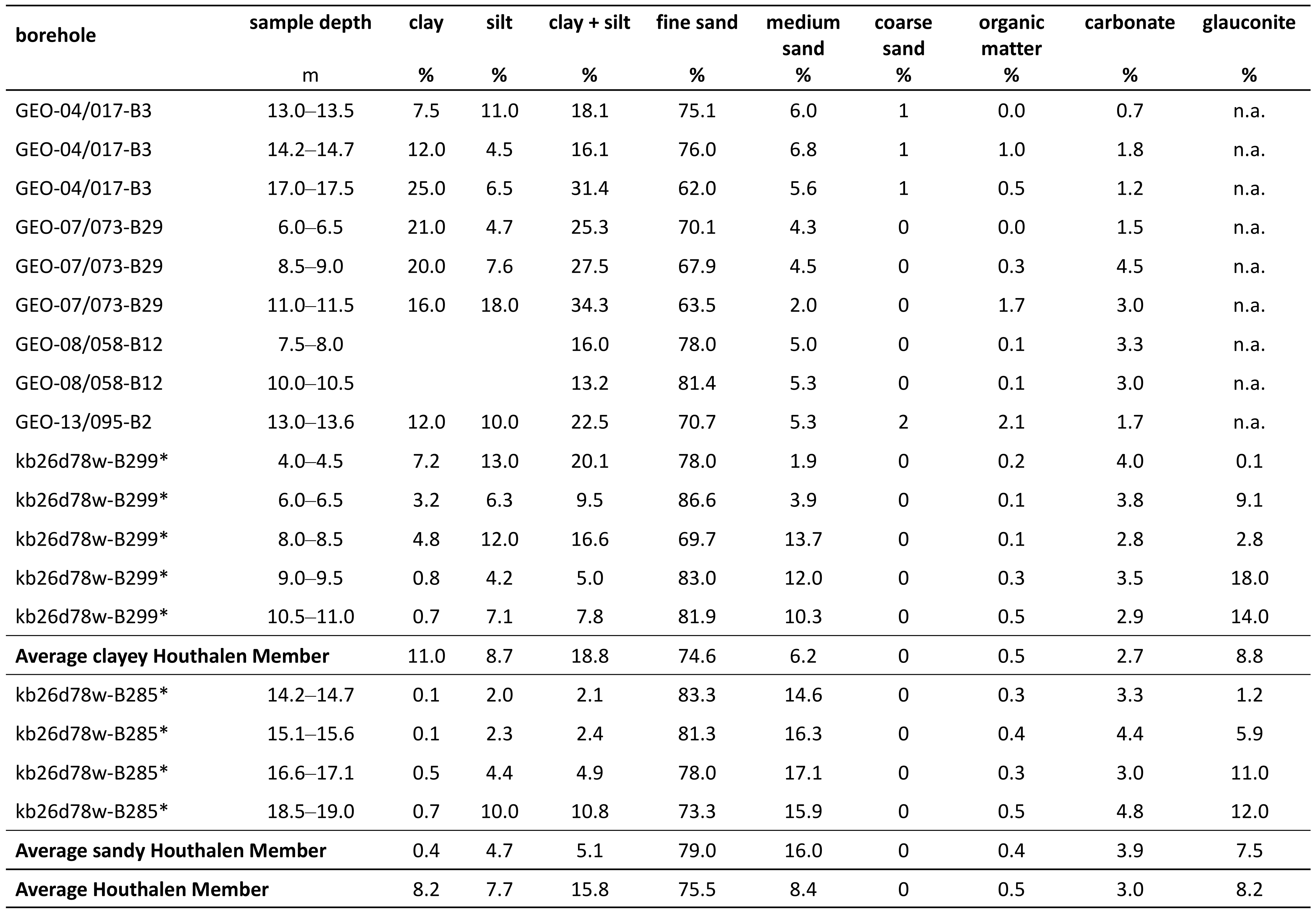
2In the west of the Belgian Province of Limburg (see Fig. 1), the lower to middle Miocene sands of the Bolderberg Formation rest unconformably on the lower Oligocene sands and clays of the Eigenbilzen Formation. Since they are hardly exposed in outcrops, the Eigenbilzen Formation and the Houthalen Member in the lower part of the Bolderberg Formation are best known from descriptions in mine shafts and borehole samples. The Eigenbilzen Formation was studied in detail by means of borehole logs by Matthijs (1999) and Vandenberghe et al. (2001). The superjacent Houthalen Member is much thinner developed and often difficult to distinguish from the upper Oligocene to lowermost Miocene Veldhoven Formation which underlies the unit in the eastern Province of Limburg. This has thus far hindered detailed studies on the Houthalen Member, therefore little is known about its facies continuity, granulometry and biostratigraphic age (Louwye et al., 2020). This study focuses on improving our knowledge of all three of these aspects. As a study area, we selected the southern Genk area (Fig. 2) where plenty of boreholes were drilled in the Houthalen Member, starting in the 1930s for the construction of the Albert Canal. For this study, we gathered sediment analyses on the borehole samples to lithologically characterize the Houthalen Member in the area. In addition, biostratigraphic analyses were performed on some of these samples by means of dinoflagellate cysts. The boreholes are irregularly distributed across the area and many of them end above the stratigraphic level of the Houthalen Member. Therefore, besides boreholes, we also made use of the available Cone Penetration Tests (CPTs) in the area. As they provide a general indication of soil type, the CPTs have been proven very useful in studying the Neogene and Oligocene in the city of Antwerp and Antwerp Campine areas (Fig. 1; Deckers & Louwye, 2020; Schiltz, 2020; Vandenberghe et al., 2020; Deckers & Everaert, 2022; Deckers & Goolaerts, 2022), and are therefore also a promising tool for studying time-equivalent deposits in the southern Genk area. Integrating the borehole and CPT data provides new insights into the architecture, composition and age of the Houthalen Member of the Bolderberg Formation in the Limburg area. It also allows a geotechnical CPT characterization of the Eigenbilzen and Bolderberg formations which can be a useful tool for further analyses of these units.
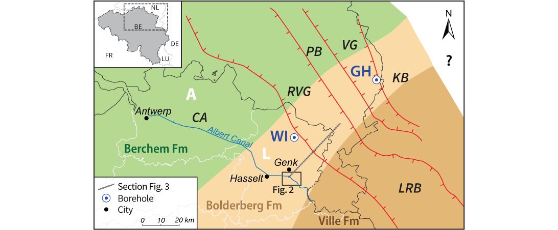
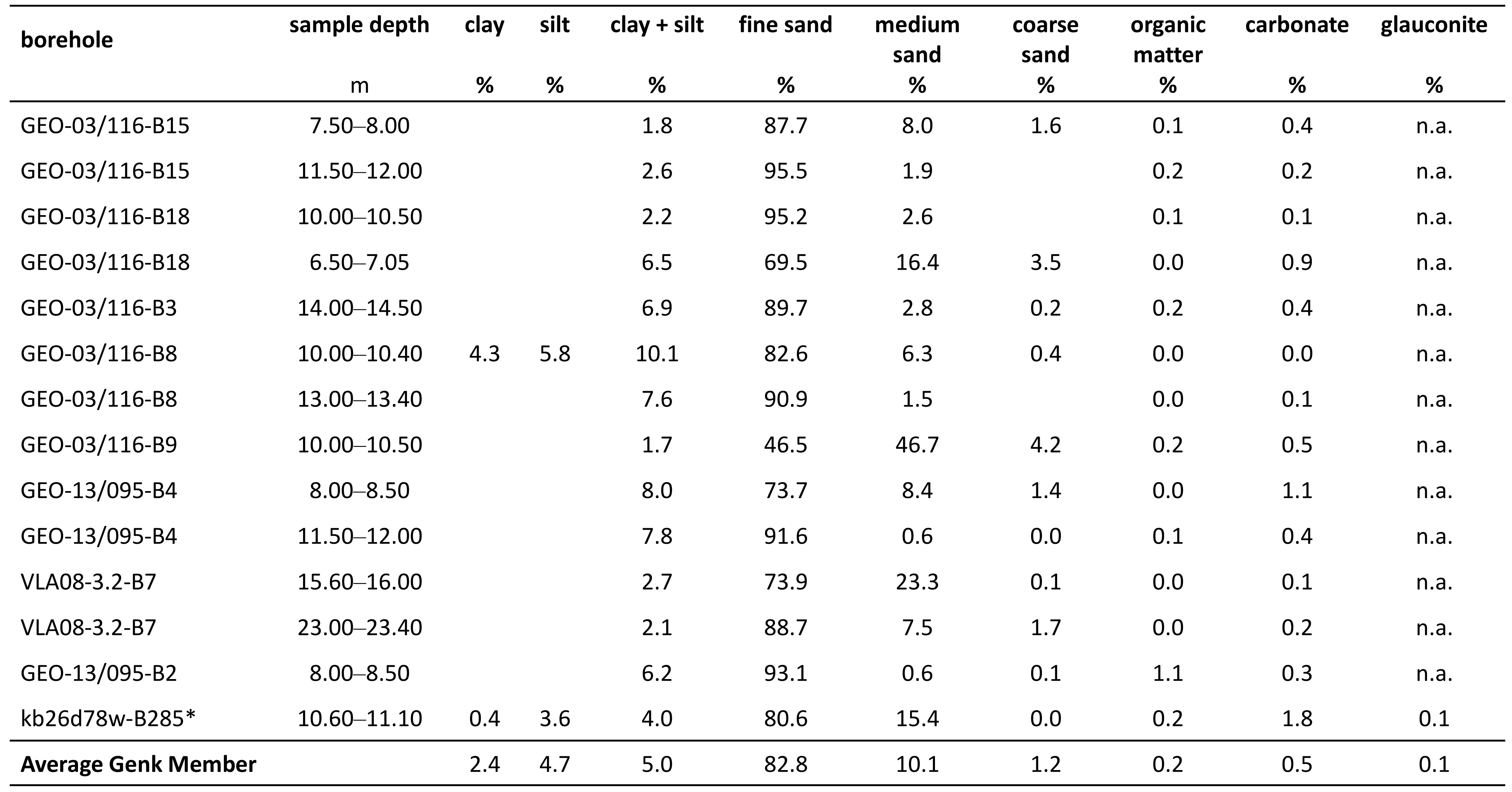
Figure 1. Northeastern Belgium and the southeastern Netherlands with the main stratigraphic and structural units, the study area of Figure 2 and the schematic section of Figure 3. This section was modified after Deckers & Louwye (2019). A = Province of Antwerp; CA = Campine area; GH = Groote Heide borehole; KB = Krefelt Block; L= Province of Limburg; LRB = Lower Rhine Basin; PB = Peel Block; RVG = Roer Valley Graben; VG = Venlo Graben; WI = Wijshagen borehole.
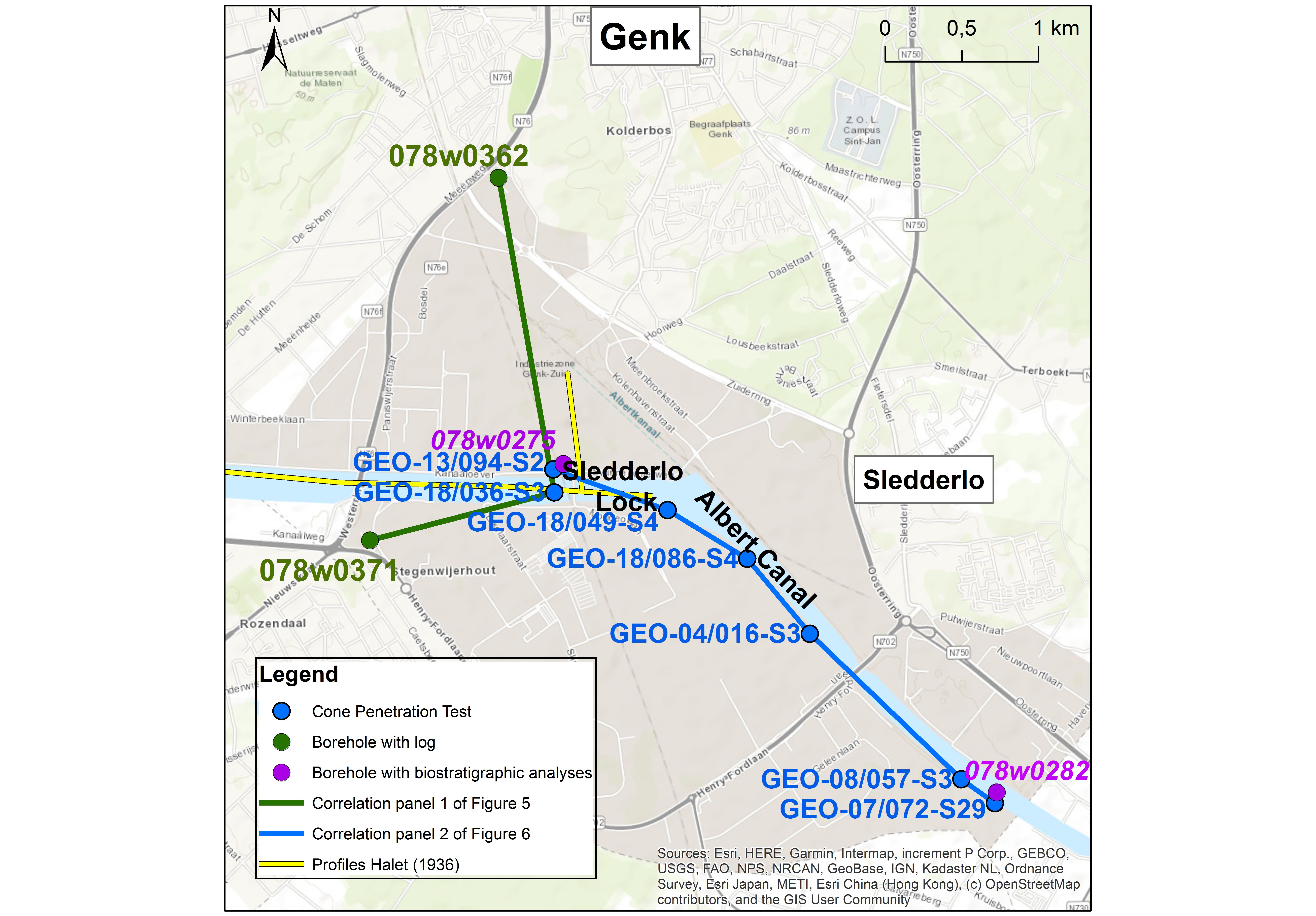
Figure 2. Overview of the study area in the southern Genk municipality with the location of the correlation profiles with the CPTs and boreholes of this study and the profile along the Albert Canal by Halet (1936a). The location of this area is indicated in Figure 1.
2. Geological background
2.1. General stratigraphic background
3The Eigenbilzen Formation is a sandy unit lying above the lower Rupelian Boom Clay (Fig. 3). It consists of grey to grey-green clayey fine sand and silt containing some glauconite pellets, especially towards the top. It contains bioturbations but no macrofossils. The Eigenbilzen Formation is well studied in the subsurface of map sheet 25 Hasselt (Matthijs, 1999) where a consistent threefold subdivision could be demonstrated on borehole logs and characterized by typical resistivity and gamma-ray signatures. These subdivisions have also been identified in and correlated between geophysical borehole logs outside the Hasselt map sheet, where they were labelled units A, B and C (Vandenberghe et al., 2001). Locally, an additional unit D can be identified. These units A-D in the Eigenbilzen Formation have not been ranked as official subdivisions of the formation. According to Van Simaeys et al. (2005) and De Man et al. (2010), the Eigenbilzen Formation has a latest Rupelian age in the eastern Province of Antwerp. Further southeast in the Province of Limburg, the Eigenbilzen Formation has a middle to latest Rupelian age (Munsterman & Deckers, 2024; Fig. 3).
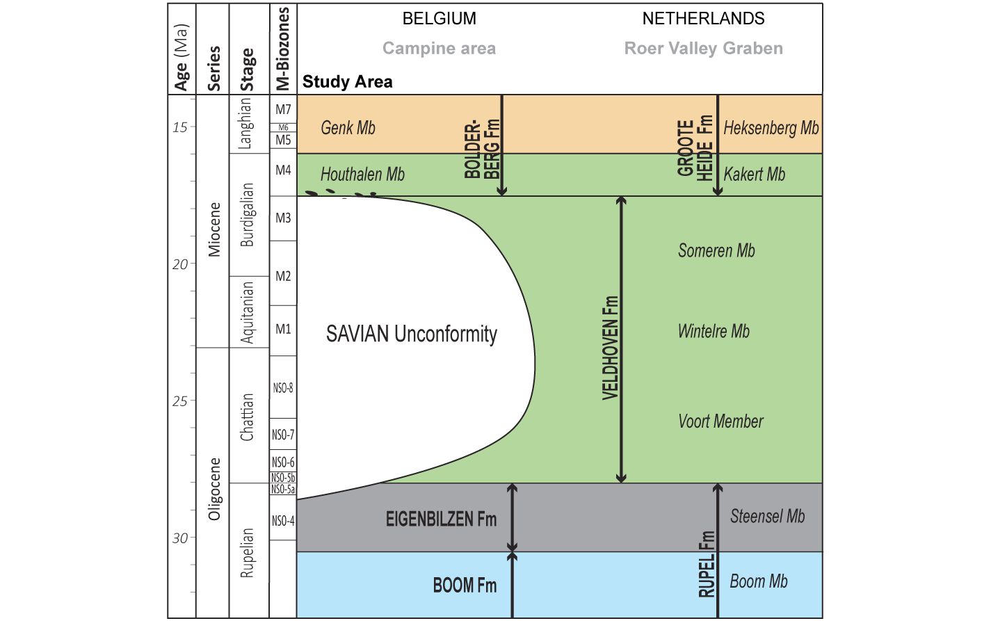
Figure 3. Schematic cross-section of the Oligocene to middle Miocene Belgian and Dutch lithostratigraphy and chronostratigraphy from the study area in the Campine area (left) towards the Roer Valley Graben (right). Modified after Munsterman & Deckers (2022). The lithostratigraphy is modified after Van Adrichem Boogaert & Kouwe (1993–1997), Deckers & Louwye (2019) and Munsterman et al. (2019). The NSO dinocyst zones are those of Van Simaeys et al. (2005), while the M-dinocyst zones are those of Munsterman et al. (2019). The biostratigraphic age of the Eigenbilzen Formation and Steensel Member is after Munsterman & Deckers (2024). The location of this cross-section is shown in Figure 1.
4The Bolderberg Formation is subdivided into a lower Houthalen Member and an upper Genk Member (Fig. 3). The Houthalen Member comprises dark green, medium fine, micaceous, very slightly ligniferous, glauconiferous sand with some mollusks. It rests unconformably upon older Miocene (Roer Valley Graben) or Paleogene (Campine area) strata, from which it is often separated by a well-developed basal gravel with dark rounded flint pebbles and shark’s teeth, the Elsloo Gravel. In the southern Genk area at the Sledderlo Lock of the Albert Canal, this basal gravel layer was encountered in most boreholes (Halet, 1936a; Fig. 4). The superjacent Genk Member consists of whitish, fine to fairly coarse and gravelly sand, locally with lignite layers and glassy quartzite banks. The age of the Houthalen Member is probably Burdigalian while the age of the Genk Member is known to be Langhian to early Serravallian (Deckers & Louwye, 2019; Fig. 3).
5In the southern Genk area, the Houthalen Member directly overlies the Eigenbilzen Formation (Fig. 3; Halet, 1936a). There consequently exists a major hiatus between them, spanning at least the Chattian and Aquitanian. Such hiatus has been related to the Savian phase and also recognized in other parts of the Campine area (see also Munsterman & Deckers, 2020; Fig. 3). Further towards the northeast or in the Roer Valley Graben, where more subsidence took place during the Oligocene and Miocene, this hiatus related to the Savian phase is (largely) absent as the Chattian to Burdigalian Veldhoven Formation underlies the Houthalen Member (Kakert Member; Munsterman & Deckers, 2022; Fig. 3).
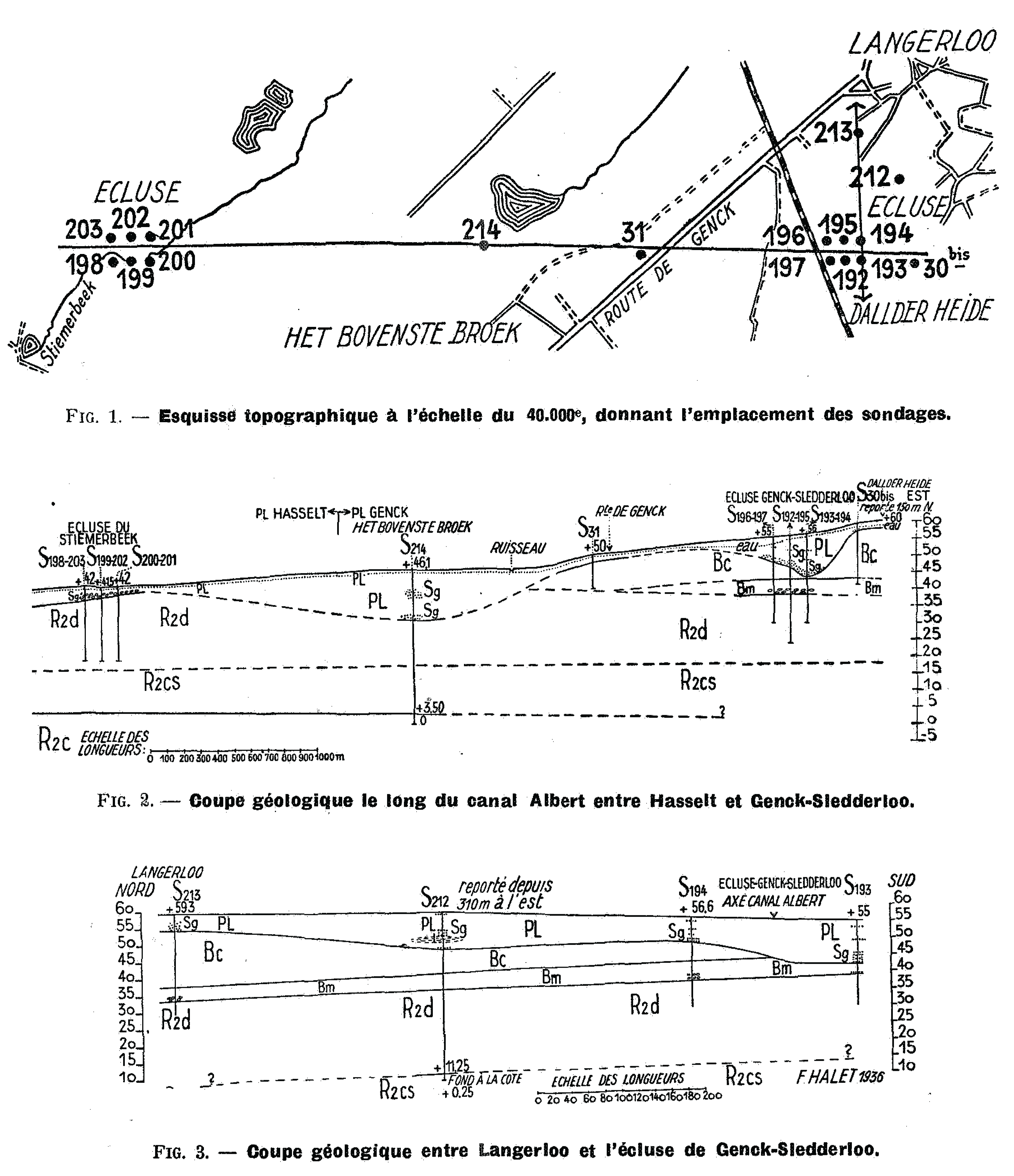
Figure 4. Eastern section of the profile drawn along the Albert Canal between Hasselt and Genk by Halet (1936a). The location of this profile is shown in Figure 2 of this study. R2c= Rupélien moyen or the current Boom Formation; R2cs= Rupélien moyen supérieur or the current clayey lower part of the Eigenbilzen Formation; R2d = Rupélien supérieur or the current sandy upper part of the Eigenbilzen Formation; Bm = Boldérien marin or the current Houthalen Member; Bc = Boldérien continental or the current Genk Member; PL= Pléistocène or the current Meuse Group; M = Moderne or the reworked.
2.2. Stratigraphic background for the study area
6Halet (1936a) drew a profile of the Oligocene to Quaternary strata along the section between Hasselt in the west and Genk in the east in preparation for the excavations for the Albert Canal. His profile was based on the interpretation of numerous boreholes along and near this section. The easternmost part of his profile is shown in Figure 4. This section is located near the Sledderlo Lock, which is the western section of our study area (Fig. 2).
7The deepest units that were encountered in the boreholes of Halet (1936a) are part of the Rupelian (Rupélien). The Rupelian was subdivided into a lower unit dominated by clay (Rupélien moyen) and an upper unit dominated by sands (Rupélien supérieur or “R2d”). The lower Rupelian unit was further subdivided into a lower unit (“R2c”) consisting of grey, compact clay and an upper unit (R2cs) consisting of sandy, grey clay with some more plastic clay levels. “R2cs” is about 10 m thick. The upper Rupelian (“R2d”) comprises very fine, glauconite-bearing sands with, in places, clayey lenses. This unit is up to 20 m thick along the profile, often eroded in its top by the Pleistocene strata (Pléistocène). In the current formal lithostratigraphy, “R2c” and “R2d” are referred to as the Boom and Eigenbilzen formations, respectively (Vandenberghe & Wouters, 2023). Halet (1936a) indeed noted that the lithology of his “R2c” is very similar to that described for the Boom Formation type area. Unit “R2cs” is not formally allocated to a particular stratigraphic unit. All Rupelian units are present throughout the profile. Most boreholes ended in the Eigenbilzen Formation and only a handful reached into the top of the Boom Formation.
8Along the same profile, the Eigenbilzen Formation or “R2d” is overlain by the Quaternary Meuse Group (Pléistocène or “PL”) in the west and the Bolderberg Formation (Boldérien) in the east. Halet (1936a) made a twofold subdivision within the Bolderberg Formation: a lower marine unit (“Bm”) that comprises green-grey, glauconitic, quartz sands with beds of rolled, large, black silex nodules and the superjacent continental unit (“Bc”) that comprises white-grey and brown, lignitic quartz sands without glauconite. The gravel layer at the base of Bm was correlative with the Elsloo gravel which is a well-known basal gravel layer of the Miocene from mine shafts further north. The marine unit (Bm) is now formally referred to as the Houthalen Member and the continental unit (“Bc”) as the Genk Member. Where the Bolderberg Formation is present, the Houthalen Member (Bm) almost always overlies the Eigenbilzen Formation (“R2d”). Only in one borehole in the westernmost extent of the Bolderberg Formation on the profile, the Genk Member (“Bc”) directly overlies the Eigenbilzen Formation. The Bolderberg Formation is unconformably overlain by the Meuse Group (“PL”).
9Further east along the Albert Canal, the profile of Halet (1936a) ends, but more widely spaced boreholes were still interpreted by him throughout the 1920s and 1930s for the construction of the Albert Canal. Contrary to the area further west, however, he made no distinction between a continental or marine Bolderberg Formation further east.
3. Dataset and methodology
3.1. Sediment analyses
10From the public Databank Ondergrond Vlaanderen (DOV) database (www.DOV.vlaanderen.be), the previous sediment analyses on borehole samples in the study area were gathered (Tables 1 and 2). These include granulometry, organic and carbonate content. Glauconite analyses were not available in the area prior to this study. Granulometric analyses of previous samples were performed by sieving for grain sizes down to 63 µm and by hydrometer for the fractions smaller than 63 µm. Carbonate content was derived using hydrochloric acid and organic matter by using hydrogen peroxide.
11In this study, additional boreholes in the northwestern (DOV kb26d78w-B285; Geological Survey of Belgium (GSB) 078w0275) and southeastern study area (DOV kb26d78w-B299; GSB 078w0282) were subjected to granulometric (laser diffraction), glauconite (Frantz Isodynamic Magnetic Separator), organic (chromatographic analysis of the TOC content) and carbonate content (hydrochloric acid) analyses (Tables 1 and 2). The stratigraphic interpretations of the latter two boreholes were taken from Halet (1935) and Halet (1936b). In the borehole of the southeastern study area, Halet (1936b) did not differentiate between the members of the Bolderberg Formation. Based on this borehole’s description of dark grey to green glauconitic, fine sands, we interpret this entire section of the Bolderberg Formation as the Houthalen Member.
12Table 1. Overview of the analyses performed on the samples in the Houthalen Member from boreholes in the study area. A distinction is made between the clayey Houthalen, corresponding to geotechnical CPT unit 4, and the sandy Houthalen Member, corresponding to geotechnical CPT unit 5a. The following grain-size classification was used: clay = up to 2 µm, silt = 2–63 µm, fine sand = 63–250 µm, medium sand = 250–500 µm and coarse sand = 500–1000 µm. n.a. = not analyzed. * = new analyses for this study.
13Table 2. Overview of the analyses performed on the samples in the Genk Member from boreholes in the study area. The following grain-size classification was used: clay = up to 2 µm, silt = 2–63 µm, fine sand = 63–250 µm, medium sand = 250–500 µm and coarse sand = 500–1000 µm. n.a. = not analyzed; * = new analyses for this study.
3.2. Dinocyst sampling and analyses
14A total of five samples were taken for analyses by dinoflagellate cyst species in order to retrieve more information on the age of the Houthalen Member. These samples were taken from the two boreholes that were also subjected to the sediment analyses in the present study (see 3.1.). These samples were gathered at the core repository of the GSB. From the borehole near the Sledderlo Lock in the westernmost study area (GSB 078w0275; DOV kb26d78w-B285; for location see Fig. 2) three samples were taken from the Houthalen Member. From the borehole near the boundary with the Zutendaal municipality in the southeasternmost study area (GSB 078w0282; DOV kb26d78w-B299; for location see Fig. 2) two samples were taken from the Houthalen Member.
15Standard palynological techniques, including HCl and HF digestion and 15 µm sieving, were applied following Janssen & Dammers (2008). No oxidation was used. The slides were mounted in glycerine jelly. One microscope slide per sample was counted until a minimum of 200 palynomorphs (spores, pollen and dinoflagellate cysts) had been identified (when present). The remainder of the slides were scanned for rare taxa. Miscellaneous fossils (e.g. green algae like Pediastrum, Botryococcus) were also counted, but kept outside the total sum of 200 specimens. The age interpretation is based on the Last Occurrence Datum (LOD) and First Occurrence Datum (FOD) of dinoflagellate cysts. For the dinoflagellate cyst taxonomy, the so-called “Lentin and Williams” index is followed (Fensome et al., 2019). Key references for Miocene successions in the North Sea area are: Dybkjær & Piasecki (2010), Köthe (2003; 2007), Louwye (2005), Louwye et al. (2010), Munsterman & Brinkhuis (2004), Munsterman et al. (2019) and Powell (1992). The dinocyst zonation scheme of Munsterman & Brinkhuis (2004) is used, recalibrated to Geological Time Scale (GTS) 2016 of Ogg et al. (2016) in Munsterman et al. (2019). The slides are stored at TNO-Geological Survey of the Netherlands, in the archive of this borehole.
3.3. CPTs
16Several CPTs were chosen for analysis along the Albert Canal based on their depth and position close to logged and sampled boreholes. Typically the cone resistance (qc) and local friction (fs) are measured by pushing an instrumented cone into the soil. These parameters and the derived friction ratio (Rf = fs/qc x 100), the latter giving a general indication of soil type, are traditionally used to determine soil layers. Robertson (1990, 2010) established soil behavior types (SBT and SBTn) and hydraulic conductivity (kSBTn) from these parameters. Schiltz (2020) proved that these derived parameters (soil behavior type indexes IcSBT, normalized soil type behavior index IcSBTn and kSBTn) showed a close analogy with gamma-ray logs in Pliocene sediments in the Antwerp Campine area. It was shown that trends of the log patterns of these parameters are similar as in gamma-ray logs and could be used for stratigraphic analysis in the same way. They proved to be very useful and more consistent than the patterns of the classical parameters (qc and Rf) for determining and correlating different stratigraphic units in sandy units with low lithological contrast. As for the analysis of the actually used CPTs, both the traditional CPT parameters (qc and Rf) were used as well as the trends in the logs of the derived SBT indexes. The latter represents fining or coarsening upward trends or cycles. As will be seen further, also for the Miocene sediments, subject in this study, the trends in gamma-ray logs are analogous with the CPT-derived parameters.
3.4. Correlation panels
17For this study, two correlation panels were created around the Albert Canal in the southern Genk municipality. The data points used for these panels are shown in Table 3 of this study and can be consulted in the DOV database via the following link: https://www.dov.vlaanderen.be/data/opdracht/2024-041450.
Table 3. Overview of the IDs of the data points shown by this study. For the boreholes, both the DOV- and GSB-IDs are given, while for the CPTs only the DOV-ID is given. If the CPT and the borehole are shown next to each other (in the same row), then they are also located very close to each other.
|
CPT DOV-ID |
Borehole DOV-ID |
Borehole GSB-ID |
Shown in which figure of this study |
|
5 |
|||
|
078w0362 |
5 |
||
|
078w0371 |
5 |
||
|
078w0275 |
6 and 7 |
||
|
6 |
|||
|
6 |
|||
|
6 |
|||
|
6 |
|||
|
078w0282 |
6 and 8 |
18Correlation panel 1 was created for a geotechnical characterization of the Eigenbilzen Formation based on correlations with borehole logs. It runs between borehole logs in the north and south of the Genk municipality and a deep CPT at the Sledderlo Lock in the easternmost section of the profile by Halet (1936a; for location see Fig. 2). The northern borehole (GSB 078w0362; DOV kb26d78w-B386) has logs across the Eigenbilzen Formation whereas the southern borehole (GSB 078w0371; DOV kb26d78w-B397) only has good quality logs (no casing) in the lower 20 m of the Eigenbilzen Formation. Correlation panel 2 was created for a geotechnical characterization of the Houthalen Member (Bolderberg Formation) based on correlation with shallow boreholes. It runs between a series of CPTs along the Albert Canal from the Sledderlo Lock in the northwest to the boundary between the Genk and Zutendaal municipalities in the southeast (for location see Fig. 2). We preferentially selected CPTs located nearby boreholes, and particularly if samples of these boreholes were granulometrically analyzed (see Tables 1 and 2).
19The boreholes, their sample analyses and CPTs were all extracted from the public DOV database (https://www.dov.vlaanderen.be/). The selected CPT and boreholes of correlation panel 1 were horizontally aligned at the base of the Eigenbilzen Formation, and the CPTs of correlation panel 2 were positioned in depth to reference level TAW (Tweede Algemene Waterpassing). Geotechnical CPT units and their correlative lithostratigraphic units were identified along the panels. For correlation panel 2, the granulometric and if available glauconite content analyses of boreholes that are located near some of these CPTs were plotted on the panel.
4. Geotechnical CPT stratigraphy
20Six major geotechnical CPT units, herein called 1 to 6, were identified from bottom to top along the CPTs of the correlation panels. The lowermost unit 1 is not reached by most of the CPTs in the study area and is only shown in correlation panel 1
21(Fig. 5). Unit 1 is characteristic of a very clayey unit (low qc and high Rf) that coarsens in unit 2 towards unit 3. The latter is characteristic of a sandy unit with some clayey intervals. The sequence of clayey intervals is the reason for subdividing unit 3 into lower subunit 3a and upper subunit 3b. Subunits 3a and 3b start with a fining upwards trend, followed by a coarsening upwards trend.
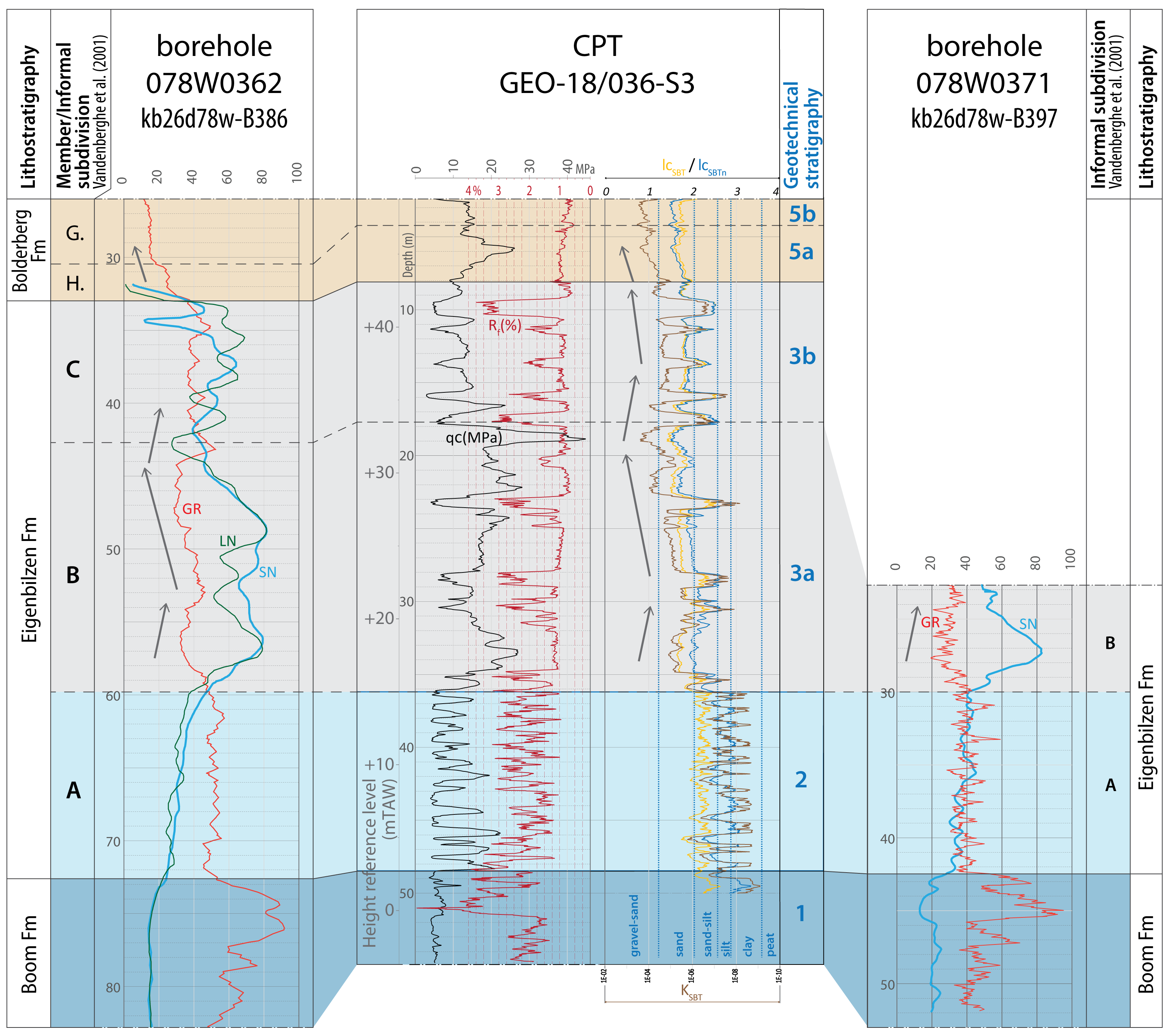
Figure 5. Correlation panel 1 between a deep CPT near the Albert Canal (Sledderlo Lock) and borehole logs north (left) and south (right) of the Albert Canal. The geotechnical CPT stratigraphy is indicated for the CPT and the lithostratigraphy for the borehole logs. Arrows indicate grain-size trends extracted from the geophysical and SBT logs, with left-pointing arrows indicating a coarsening upward trend and right-pointing arrows a fining upward trend. The panel is flattened at the base of geotechnical CPT unit 3a or geophysical unit Eigenbilzen B. For the CPT, besides the standard qc and Rf values, also the curves with derived SBT indexes and k are shown based on Robertson (1990, 2010). The location of this panel is shown in Figure 2. G. = Genk Member; GR = gamma-ray; H. = Houthalen Member; IcSBTn = normalized soil behavior type index (Robertson, 1990; 2010); kSBT = hydraulic conductivity (m/s; Robertson, 2010); LN = long normal resistivity; qc = cone resistance; Rf = Friction ratio; SN = short normal resistivity.
22In most of the study area, unit 3 is overlain by unit 4 which shows low qc and high Rf values, indicative of a high amount of fine fraction. Unit 4 shows a decrease in thickness from 7 m in the southeast towards less than 1 m in the northwest. In the westernmost study area (CPT of Fig. 5 and northwesternmost borehole in Fig. 6), unit 4 is absent and unit 3 is directly overlain by unit 5. The geotechnical CPT expression of unit 5 is characteristic of a clean sand, with relatively high qc and low Rf values. Albeit subtle, based on the SBT analyses, unit 5 can be subdivided into lower subunit 5a and upper subunit 5b. Subunit 5a shows a coarsening upward trend starting from unit 4 towards unit 5b. Subunit 5b shows a more subtle overall coarsening upward trend. On CPTs GEO-18/036-S3 (Fig. 5) and GEO-13/094-S2 the twofold subdivision within unit 5 is more clear than in CPTs GEO-18/049-S4 and GEO-18/086-S4 (Fig. 6). Southeast of the latter CPT, unit 5 is strongly truncated at its top so making a subdivision was no longer possible (Fig. 6).
23Unit 6 represents the upper part of the subsurface profile. It unconformably overlies the subjacent units and completely removed unit 5 in the southeastern study area. Unit 6 shows many different geotechnical CPT facies. Sometimes it can be distinguished by lower qc values than unit 5, sometimes even very low values are indicative for soft soils. In other cases, the unit shows similar qc and Rf values as unit 5 but is separated by a basal unit with lower qc and higher Rf values from unit 5.
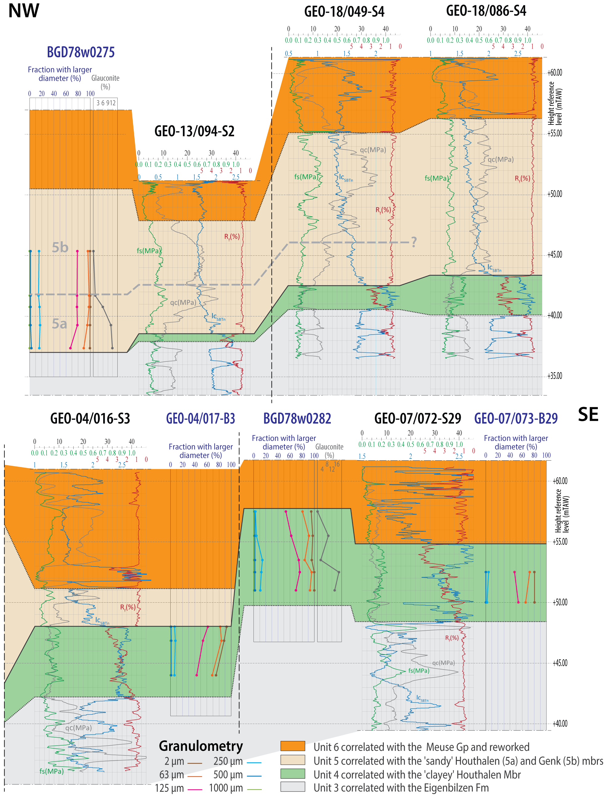
Figure 6. Correlation panel 2 between CPTs from the Sledderlo Lock in the northwest up to the boundary with the Zutendaal municipality in the southeast. Nearby some of these CPTs, boreholes are located from which some of the samples were analyzed for—among others—granulometry. The results of these granulometric analyses are plotted next to the nearby CPTs. Both the geotechnical CPT stratigraphy and correlative lithostratigraphy are indicated. Note that geotechnical CPT unit 4 or the clayey facies of the Houthalen Member thins towards the northwest. The location of this panel is shown in Figure 2. fs = local friction; IcSBTn = normalized soil behavior type index (Robertson, 1990; 2010); qc = cone resistance; Rf = Friction ratio.
5. Correlation between geotechnical CPT units and the lithostratigraphy
24- At the Sledderlo Lock, geotechnical CPT unit 1 is located at a depth beneath +2.5 m TAW reference level (Fig. 5), which corresponds to the exact stratigraphic level of unit R2c or the Boom Formation according to the profile of Halet (1936a; Fig. 4). The Boom Formation consists of clay which is consistent with the low qc and high Rf values of geotechnical CPT unit 1 (Fig. 5). It corresponds with low resistivity and high gamma-ray values based on correlations with nearby borehole logs. This geophysical expression is consistent with what is known from literature about the Boom Formation (e.g. Vandenberghe et al., 2001). The anomalous high Rf values in the uppermost part of this unit 1 correlate with anomalous high gamma-ray values on the borehole logs. The high gamma-ray or radioactivity can be related to the high content of organic material as known from the literature (e.g. Vandenberghe et al., 2001) and as observed in the cored southern borehole of correlation panel 1 (GSB 078w0371; DOV kb26d78w-B397). Organic material typically binds radioactive elements. This organic content in the Boom Formation reaches up to over 5% (Vandenberghe, 1978). Organic material also typically increases the Rf values (Lengkeek & Brinkgreve, 2022), which provides an explanation for why the Rf spike coincides with the gamma-ray spike. The high gamma-ray interval typically corresponds to the base of the Putte Member of the Boom Formation (Vandenberghe et al., 2001).
25- At the Sledderlo Lock, geotechnical CPT unit 2 is located at a depth between +2.5 m and +15 m TAW reference level (Fig. 5), which corresponds to the stratigraphic level of unit R2cs according to the profile of Halet (1936a; Fig. 4). The latter author describes R2cs as sandy clay. The extracted SBT charts (based on Robertson, 1990) indicate an alternation of 1 m or less thick clay (low qc) and sand-silt (higher qc) intervals within geotechnical CPT unit 2 (Fig. 5). Indeed, in the borehole with logs south of Sledderlo (GSB 078w0371; DOV kb26d78w-B397), which is cored for this section, the lithology is described as alternations between clayey sand and sandy clay. Correlation panel 1 shows that geotechnical CPT unit 2 corresponds to the geophysical unit Eigenbilzen A of the Eigenbilzen Formation as defined by Vandenberghe et al. (2001). The alternating qc values in geotechnical CPT unit 2 correspond to alternating resistivity values in geophysical unit Eigenbilzen A, which further supports our correlation between these units. The gamma-ray log shows, like the Rf log, strongly alternating, overall high values. Vandenberghe (1978) also describes the layered nature of this lower part of the Eigenbilzen Formation.
26- At the Sledderlo Lock, geotechnical CPT unit 3 is located at a depth between +15 m and about +40 m TAW reference level (Figs 5 & 6), which corresponds to the stratigraphic level of unit R2d or the Eigenbilzen Formation according to the profile of Halet (1936a; Fig. 4). The latter describes this unit as sand with locally clay lenses. The sands are expressed on the CPTs as up to 5 meters thick units with higher qc (15 MPa) and low Rf (1%) values (Figs 5 & 6). The clay lenses are expressed by low qc (<10 MPa) and higher Rf (2%) values. The intervals rich in clay lenses are less than 0.5 m thick. The thickness of the whole of unit 3 ranges around 20–25 m, which is similar to the thickness of R2d from Genk up to Hasselt according to Halet (1936a). In the lower part of unit 3, herein called subunit 3a, clayey intervals are less frequent than in the upper part of unit 3, herein called subunit 3b. Correlation panel 1 shows that geotechnical CPT subunits 3a and 3b correspond to the geophysical units Eigenbilzen B and C as defined by Vandenberghe et al. (2001; Fig. 5). Based on the CPT signature, geotechnical CPT unit 3a shows a fining upwards trend followed by a coarsening upwards trend, which suggests the presence of a maximum flooding surface near the center of the unit (see also Vandenberghe & Wouters, 2023). Vandenberghe et al. (2001) show that this central (low resistivity) level can often be correlated between borehole logs. The rhythmic alternation of sand and clay as described for geophysical unit Eigenbilzen C nicely correlates with those observed in geotechnical CPT subunit 3b, which supports our correlation between these units. Furthermore, geophysical unit Eigenbilzen B typically has a thickness of 21 m (Matthijs, 1999), which is exactly the thickness of geotechnical CPT subunit 3a. Geophysical unit Eigenbilzen C can reach thicknesses up to 13 m according to Matthijs (1999), which is more than geotechnical CPT subunit 3b in the study area. Since geotechnical CPT subunit 3b of the Eigenbilzen Formation (Rupelian) is unconformably overlain by the much younger Bolderberg Formation (Burdigalian, see next paragraph), its reduced thickness in the study area can be related to post-depositional erosion. Probably as the result of the same process, the geophysical unit Eigenbilzen D, which is locally recognized in the uppermost part of the Eigenbilzen Formation (Vandenberghe & Wouters, 2023), is also absent in the study area.
27- Unit 4 is corresponding with the Houthalen Member of the Bolderberg Formation. This geotechnical CPT unit lies outside the profile of Halet (1936a), so a direct correlation with the latter study cannot be made. In the boreholes near the CPTs of correlation panel 2, a correlative interval of unit 4 is described as dark grey to dark green, rich in mica and containing organic material (wood or lignitic fragments), which all matches the formal description of the Houthalen Member. The granulometric analyses of 15 samples from boreholes near the CPTs (Table 1; Fig. 6) show that the corresponding levels are dominated by fine sand (average 74.6%), with clay and silt percentages on average 10.8% and 8.7%, which also matches the formal descriptions of the Houthalen Member as a clayey medium fine-grained sandy unit.
28- At the Sledderlo Lock, geotechnical CPT unit 5 is located at a depth between +40 m and +50 m TAW reference level (Figs 5 & 6), which corresponds to the stratigraphic level of the Bolderberg Formation according to the profile of Halet (1936a; Fig. 4). The latter made the distinction between a lower unit comprising the current Houthalen Member (3 m to 5 m thick) and an upper unit comprising the current Genk Member. The main difference between these members is the presence of glauconite and related green shading in the Houthalen Member and the (near) absence in the Genk Member. The analyses of samples from a borehole at the Sledderlo Lock (078w0275; DOV kb26d78w-B285) show glauconite contents in the Houthalen Member decreasing upwards from 11.8% in the base to 1.2% in the top (Table 1), while the sample in the Genk Member showed a glauconite content of only 0.1% (Table 2). The distinction between these members by Halet (1936a) can be correlated to the geotechnical CPT subdivision of unit 5 into subunits 5a and 5b. Unit 5a correlates with the Houthalen Member and unit 5b with the Genk Member. The low, very uniform Rf values of unit 5 are indicative of low clay and silt contents. This is confirmed by the analyses of 17 borehole samples that correspond to the stratigraphic level of unit 5 and show a combined clay and silt content of less than 6% (sandy Houthalen in Table 1 and Genk Member in Table 2). The geotechnical CPT analyses reveal an overall coarsening upward trend in subunit 5a, which is consistent with the granulometric analyses on correlative levels of borehole 078w0275 (DOV kb26d78w-B285; see Figure 6).
29- Unit 6 corresponds to the Quaternary strata. The lower part of the Quaternary comprises the (reworked) coarse fluvial sands and gravels of the Meuse Group in the area, which is consistent with the high qc and generally low Rf values. The top is often generally characterized by very low qc values due to the undercompaction of the soils. The base of the Quaternary is very erosive and has removed most of the geotechnical CPT unit 5 in the southeastern study area (Fig. 6).
6. Biostratigraphic analyses of the Houthalen Member
6.1. Borehole in the northwestern study area (GSB 078w0275; DOV kb26d78w-B285)
30The three samples from this borehole, in the interval 19–14.8 m, were taken at the levels corresponding to geotechnical CPT unit 5a (Fig. 6). The age of dinocyst assemblages from all samples is interpreted as late Burdigalian, biozone SNSM4 sensu Munsterman et al. (2019; Fig. 7). Cerebrocysta poulsenii and Labyrinthodinium truncatum are missing. Exochosphaeridium insigne is present in all samples. Other chronostratigraphic significant dinocysts are Cousteaudinium aubryae, Distatodinium paradoxum, and Hystrichosphaeropsis obscura. Particularly in the deepest core sample 18.1–19.0 m massive reworking is notable from the subjacent upper Rupelian Eigenbilzen Formation. The reworking is represented by dinocysts like Areoligera semicirculata, Chiropteridium galea, Cordosphaeridium cantharellum, Deflandrea phosphoritica, Dinopterygium sp., Homotryblium vallum, Membranophoridium connectum, Wetzeliella gochtii and Wetzeliella symmetrica.
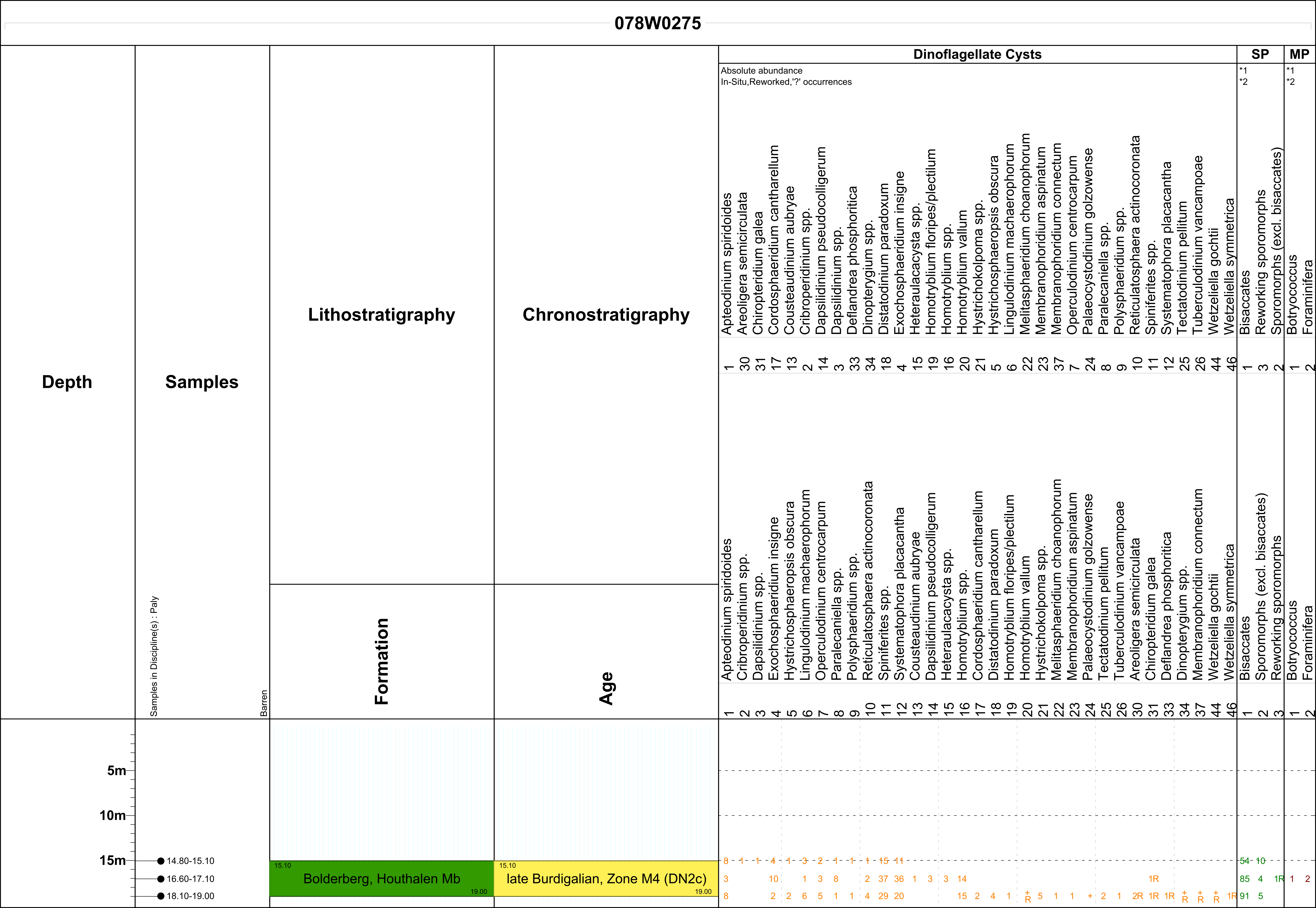
Figure 7. Results of biostratigraphic analyses of three samples from borehole 078w0275 near the Sledderlo Lock in the northwestern study area. For location of the borehole, see Figure 2.
6.2. Borehole in the southeastern study area (GSB 078w0282; DOV kb26d78w-B299)
31The two samples from this borehole were taken at the levels corresponding to geotechnical CPT unit 4. The uppermost sample, interval 6.5–7.0 m, of the Houthalen Member is poor in palynomorphs. The age assessment derived from the dinocyst assemblage of the lowest sample, interval 9.0–9.5 m, shows a late Burdigalian, biozone SNSM4 sensu Munsterman et al. (2019; Fig. 8). The association is similar to those from the samples of the Houthalen Member in the borehole in the northwestern study area (see 6.1.), including Exochosphaeridium insigne. Reworking is however very rarely recorded, like in those upper two samples.
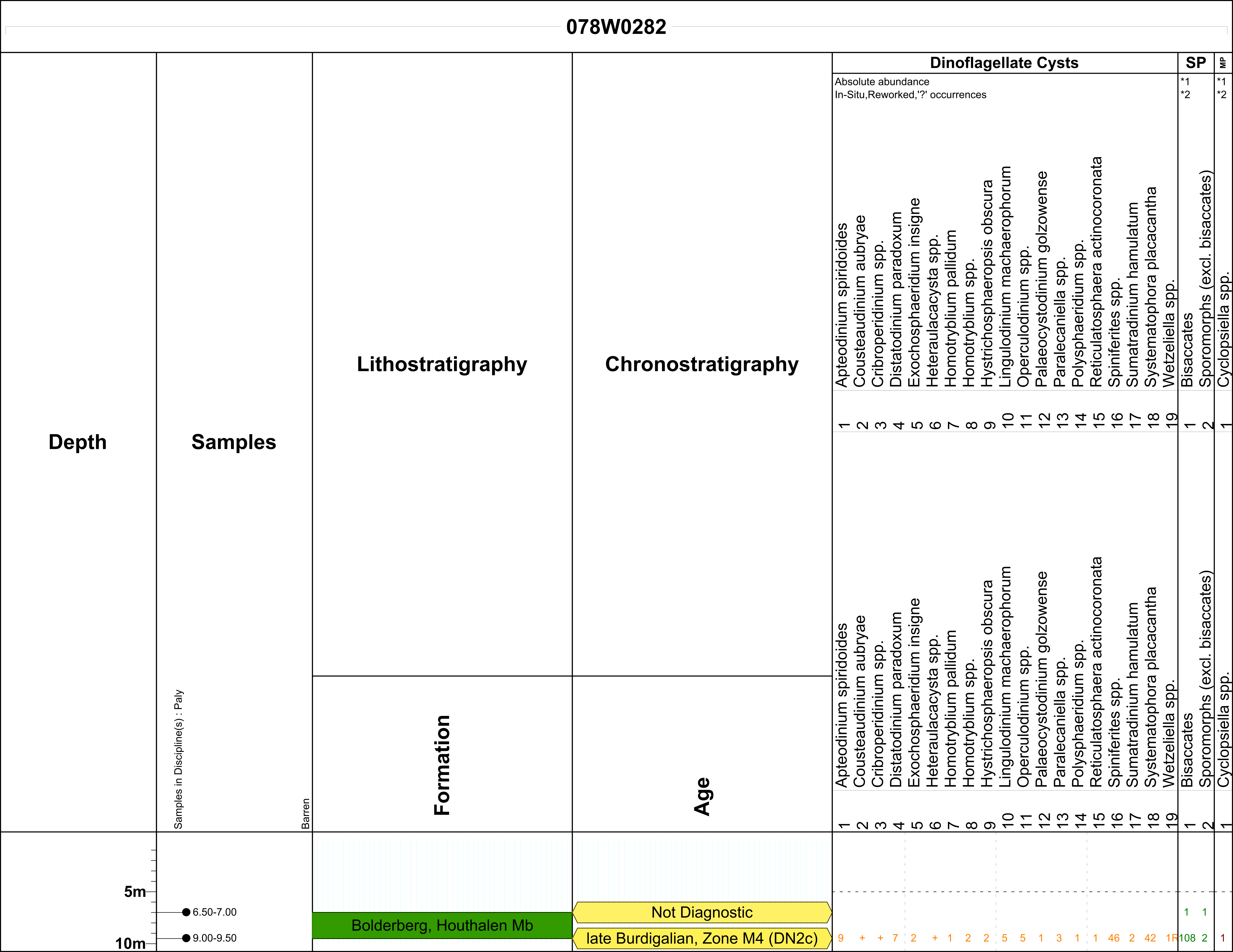
Figure 8. Results of biostratigraphic analyses of two samples from borehole 078w0282 at the boundary with the Zutendaal municipality in the southeastern study area. For location of the borehole, see Figure 2.
7. Discussion and conclusions
32This study shows that the Rupelian units of the Boom and Eigenbilzen formations as identified in boreholes by Halet (1936a) along the Albert Canal correlate with distinct geotechnical CPT units. These geotechnical CPT units also nicely correlate with geophysical units (A, B and C) within the Eigenbilzen Formation as established by Vandenberghe et al. (2001) based on Matthijs (1999). This shows that the CPTs can form an important addition to the relatively small number of borehole logs for stratigraphic analyses.
33Throughout the study area, the Eigenbilzen Formation is overlain by the Houthalen Member of the Bolderberg Formation. The biostratigraphic analyses of samples from this unit taken from two boreholes at the opposite side of the study area indicate it has late Burdigalian age (biozone SNSM4 sensu Munsterman & Brinkhuis, 2004 or E. insigne biozone sensu Dybkjær & Piasecki, 2010; Figs 7 & 8). This inferred Burdigalian age for the Houthalen Member agrees with previous biostratigraphical studies with calcareous microfossils on the unit (Louwye et al., 2020). The same SNSM4 biozone was also established in the Kiel Member of the Berchem Formation in the Antwerp area (Everaert et al., 2020; for location see Fig. 1). In the Netherlands, the Kakert Member of the Groote Heide Formation holds a similar biozone (Munsterman & Deckers, 2022), which therefore for the first time proves the age-equivalence of both units, confirming the stratigraphic scheme of Figure 3. Deckers & Louwye (2019) have shown that the superjacent Genk Member holds the younger SNSM5 to SNSM7 biozones sensu Munsterman et al. (2019) in Wijshagen borehole, located to the north of the study area (for location see Fig. 1).
34In this study, we geotechnically characterized the Houthalen Member based on the correlation of CPTs along the Albert Canal. The benefits of using the CPTs is their denser spacing in the area, objectivity, and a much higher vertical resolution in comparison with boreholes. The CPT correlation panels show that the Houthalen Member has two geotechnically different facies, herein referred to as geotechnical CPT units 4 and 5a. The correlations with boreholes indicate that these geotechnical CPT facies are also lithologically distinct. In the southeast, geotechnical CPT unit 4 is only present and correlates with a relatively clayey Houthalen Member, consisting of 18.8% of combined silt and clay fraction (Table 1). In the northwest, geotechnical CPT unit 4 is thin or absent and geotechnical CPT facies 5a correlates with a relatively sandy Houthalen Member, consisting of only 5.1% of combined silt and clay fraction (Table 1). Whereas the clay fraction is often nearly absent in the sandy Houthalen Member (0.4% on average; Table 1), it reaches values of over 20% in some samples of the clayey Houthalen Member (10.8% on average; Table 1).
35Besides granulometry, also the gravel or pebble content is different for the clayey and sandy Houthalen Member. For the sandy Houthalen Member in the northwestern study area, one or more levels with gravel or pebbles are often described, while that is not the case for the clayey Houthalen Member in the southeastern study area. In the analyzed borehole by this study at the Sledderlo Lock, two levels with rounded silex pebbles (up to 2 cm diameter) were noted within the center of the sandy Houthalen Member (Halet, 1935).
36Contrary to the clayey Houthalen Member, the geotechnical CPT facies of the sandy Houthalen Member is very similar to the superjacent Genk Member. Both show high qc and low Rf values indicative of their low amount of fines. Organic material content and especially carbonate content of the sandy Houthalen Member exceed those of the Genk member (compare Tables 1 and 2). The most significant lithological difference between the sandy Houthalen Member and the Genk Member, however, is the higher glauconite content and related sediment color in the first compared to the latter, which is almost devoid of glauconite. Glauconite analyses on four samples indicate that the sandy Houthalen Member has an upward decreasing glauconite content, from 11.8% in the base to 1.2% in the top (Table 1). Based on one sample the glauconite content of the Genk Member is 0.1% (Table 2), which is consistent with literature (Adriaens, 2015; Louwye et al., 2020). As the glauconite content decreases upwards, the sandy Houthalen Member gradually transitions into the Genk Member. The granulometric analyses of four samples indicate that the sandy Houthalen Member coarsens towards the Genk Member (Table 1), which is consistent with the gradually upward decreasing IcSBTn values within the sandy Houthalen Member on nearby CPTs (Fig. 6). In contrast, the clayey Houthalen Member has a very sharp upper boundary on the CPTs.
37Hence, this study provides evidence for the existence of two types of facies of the Houthalen Member, distinguishable from each other by the amount of fines and the presence of pebble layers. More data (borehole and CPT analyses) outside the small study area are needed to corroborate the regional significance of the two-fold subdivision within the Houthalen Member. If significant, it could be preferable to formally split up the Houthalen Member into two distinct members.
38Correlation panel 2 of this study shows that geotechnical CPT unit 4, correlative to the clayey Houthalen Member, reaches thicknesses of over six meters in the southeastern study area (Fig. 6). This is a minimum thickness since the top is overlain by the erosive Quaternary unit. From the southeastern study area, geotechnical CPT unit 4 thins—across only 3.6 km—towards absence in the northwestern study area (Fig. 6). Due to Quaternary erosion, we were unable to establish thickness trends of the superjacent geotechnical CPT unit 5a, correlative to the sandy Houthalen Member. Nevertheless, the thickness changes of the clayey Houthalen Member across relatively small distances highlight the sedimentological complexity within the unit.
Acknowledgments
39This article results from the project “Geological questions for the Neogene” of the VLAKO reference task, ordered by the Bureau for Environment and Spatial Development – Flanders, VPO. We are grateful to Katrien De Nil, Jan van Roo and Jasper Verhaegen from VPO for the fruitful collaboration that made the work on this project possible. The same persons are also thanked, together with Ilse Vergauwen and Chandra Algoe (MOW), for the constructive discussions that shaped this article. Katrijn Dirix (VITO) is thanked for database support and Katleen van Baelen (VITO) is thanked for her excellent work on the figures. We thank Marleen De Ceukelaire (GSB, Brussels) for making the Genk borehole samples available for study. Reviews by Gauthier van Alboom, Noël Vandenberghe and an anonymous reviewer led to significant improvements in the article.
Author contribution
40Jef Deckers conceptualized the research strategy, made the correlations and collected the samples. Dirk Munsterman studied the palynology. Roel De Koninck gathered and processed the sediment analyses from the DOV database. Marco Schiltz critically analyzed the CPT correlations and added the SBT analyses. All authors took part in the writing of the paper.
Data Availability
41The borehole and CPT data that support the findings of this study are openly available via https://www.dov.vlaanderen.be/data/opdracht/2024-041450.
References
42Adriaens, R., 2015. Neogene and Quaternary clay minerals in the southern North Sea. Unpublished Ph.D. Thesis, KU Leuven, Leuven, 272 p.
43Deckers, J. & Everaert, S., 2022. Distinguishing the Miocene Kiel and Antwerpen Members (Berchem Formation) and their characteristic horizons using Cone Penetration Tests in Antwerp (northern Belgium). Geological Journal, 57, 2129–2143. https://doi.org/10.1002/gj.4384
44Deckers, J. & Goolaerts, S., 2022. Cone Penetration Test characterization of middle and upper Miocene lithostratigraphic units near Antwerp International Airport. Geologica Belgica, 25/3-4, 89–98. https://doi.org/10.20341/gb.2022.002
45Deckers, J. & Louwye, S., 2019. A reinterpretation of the ages and depositional environments of the lower and middle Miocene stratigraphic records in a key area along the southern margin of the North Sea Basin. Geological Magazine, 156/3, 525–532. https://doi.org/10.1017/S0016756817000991
46Deckers, J. & Louwye, S., 2020. The architecture of the Kattendijk Formation and the implications on the early Pliocene depositional evolution of the southern margin of the North Sea Basin. Geologica Belgica, 23/3-4, 323–331. https://doi.org/10.20341/gb.2020.017
47De Man, E., Van Simaeys, S., Vandenberghe, N., Harris, W.B. & Wampler, J.M., 2010. On the nature and chronostratigraphic position of the Rupelian and Chattian stratotypes in the southern North Sea basin. Episodes, 33/1, 3–14. https://doi.org/10.18814/epiiugs/2010/v33i1/002
48Dybkjær, K. & Piasecki, S., 2010. Neogene dinoflagellate cyst zonation for the eastern North Sea Basin, Denmark. Review of Palaeobotany and Palynology 161, 1–29. https://doi.org/10.1016/j.revpalbo.2010.02.005
49Everaert, S., Munsterman, D., De Schutter, P., Bosselaers, M., Van Boeckel, J., Cleemput, G. & Bor, T., 2020. Stratigraphy and palaeontology of the lower Miocene Kiel Sand Member (Berchem Formation) in temporary exposures in Antwerp (northern Belgium). Geologica Belgica, 23/3-4, 167–198. https://doi.org/10.20341/gb.2020.025
50Fensome, R.A., Williams, G.L. & MacRae, R.A., 2019. Lentin and Williams index of fossil dinoflagellates. AASP Contribution series, 50, 1173 p.
51Halet, P., 1935. Borehole descriptions Genk Sledderlo 078w0275. Geological Survey of Belgium. https://collections.naturalsciences.be/ssh-geology-archives/arch/078w/078w0275.txt, accessed 22/03/2023.
52Halet, F., 1936a. Le Néogène et l’Oligocène entre Hasselt et Genk. Bulletin de la Société belge de Géologie, de Paléontologie et d’Hydrologie, 46, 194–199.
53Halet, P., 1936b. Borehole descriptions Genk Sledderlo 078w0282. Geological Survey of Belgium. https://collections.naturalsciences.be/ssh-geology-archives/arch/078w/078w0282.txt, accessed 22/03/2023.
54Janssen, N. & Dammers, G., 2008. Sample processing for pre-Quaternary palynology. Internal TNO report, May 2008.
55Köthe, A., 2003. Dinozysten-Zonierung im Tertiär Norddeutschlands. Revue de Paléobiologie, 22/2, 895–923.
56Köthe, A., 2007. Cenozoic biostratigraphy from the German North Sea sector (G-11-1 borehole, dinoflagellate cysts, calcareous nannoplankton) [Känozoische Biostratigraphie aus dem Deutschen Nordsee-Sektor (Bohrung G-11-1, Dinoflagellatenzysten, Kalknannoplankton)]. Zeitschrift der Deutschen Gesellschaft für Geowissenschaften, 158, 287–327. https://doi.org/10.1127/1860-1804/2007/0158-0287
57Lengkeek, H.J. & Brinkgreve, R.B.J., 2022. CPT-based unit weight estimation extended to soft organic clays and peat: An update. In Gottardi, G. & Tonni, L. (eds), Cone Penetration Testing 2022. CRC Press, London, 503–508. https://doi.org/10.1201/9781003308829-71
58Louwye, S., 2005. The Early and Middle Miocene transgression at the southern border of the North Sea Basin (northern Belgium). Geological Journal, 40/4, 441–456. https://doi.org/10.1002/gj.1021
59Louwye, S., Marquet, R., Bosselaers, M. & Lambert, O., 2010. Stratigraphy of an Early–Middle Miocene sequence near Antwerp in northern Belgium (southern North Sea Basin). Geologica Belgica, 13/3, 269–284.
60Louwye, S., Deckers, J., Verhaegen, J., Adriaens, R., & Vandenberghe, N., 2020. A review of the lower and middle Miocene of northern Belgium. Geologica Belgica, 23/3-4, 137–156. https://doi.org/10.20341/gb.2020.010
61Matthijs, J., 1999. Toelichtingen bij de geologische kaart van België, Vlaams Gewest: kaartblad 25, Hasselt [1/50 000]. Belgische Geologische Dienst en Ministerie van de Vlaamse Gemeenschap, Afdeling Natuurlijke Rijkdommen en Energie, Brussel, 104 p.
62Munsterman, D.K. & Brinkhuis, H., 2004. A southern North Sea Miocene dinoflagellate cyst zonation. Netherlands Journal of Geosciences / Geologie en Mijnbouw, 83/4, 267–285. https://doi.org/10.1017/S0016774600020369
63Munsterman, D.K. & Deckers, J., 2020. The Oligocene/Miocene boundary in the ON-Mol-1 and Weelde boreholes along the southern margin of the North Sea Basin, Belgium. Geologica Belgica, 23/3-4, 127–135. https://doi.org/10.20341/gb.2020.007
64Munsterman, D.K. & Deckers, J., 2022. Biostratigraphic ages and depositional environments of the upper Oligocene to lower Miocene Veldhoven Formation in the central Roer Valley Rift System (SE Netherlands-NE Belgium). Netherlands Journal of Geosciences, 101, e6. https://dx.doi.org/10.1017/njg.2022.3
65Munsterman, D.K. & Deckers, J., 2024. Cross-border correlations showing diachronous lithostratigraphic units in the southeastern North Sea Basin during the Early Oligocene (middle-late Rupelian). Netherlands Journal of Geosciences, 103, e11. https://doi.org/10.1017/njg.2024.10
66Munsterman, D.K., ten Veen, J.H., Menkovic, A., Deckers, J., Witmans, N., Verhaegen, J., Kerstholt-Boegehold, S.J., van de Ven, T. & Busschers, F.S., 2019. An updated and revised stratigraphic framework for the Miocene and earliest Pliocene strata of the Roer Valley Graben and adjacent blocks. Netherlands Journal of Geosciences, 98, e8. https://doi.org/10.1017/njg.2019.10
67Ogg, J.G., Ogg, G.M. & Gradstein, F.M., 2016. A Concise Geologic Time Scale. Elsevier, Amsterdam, 234 p. https://doi.org/10.1016/C2009-0-64442-1
68Powell, A.J., 1992. Dinoflagellate cysts of the Tertiary System. In Powell, A.J. (ed.), A Stratigraphic Index of Dinoflagellate Cysts. Chapman and Hall, London, British Micropalaeontological Society Publication Series, 155–272.
69Robertson, P.K., 1990. Soil classification using the cone penetration test. Canadian Geotechnical Journal, 27/1, 151–158. https://doi.org/10.1139/t90-014
70Robertson, P.K., 2010. Soil behaviour type from the CPT: an update. 2nd International Symposium on Cone Penetration Testing, Huntington Beach, CA, USA, 2, 575–583.
71Schiltz, M., 2020. On the use of CPTs in stratigraphy: recent observations and some illustrative cases. Geologica Belgica, 23/3-4, 399–411. https://doi.org/10.20341/gb.2020.019
72Van Adrichem Boogaert, A.H. & Kouwe, W.F.P., 1993–1997. Stratigraphic Nomenclature of the Netherlands, revision and update by RGD and NOGEPA. Mededelingen Rijks Geologische Dienst, 50 (section I), 39 p.
73Vandenberghe, N., 1978. Sedimentology of the Boom Clay (Rupelian) in Belgium. Verhandelingen van de Koninklijke Academie voor Wetenschappen, Letteren en Schone Kunsten van België, Klasse der Wetenschappen, 40/147, 137 p.
74Vandenberghe, N. & Wouters, L., 2023. Lithostratigraphic Information Sheets: Rupel Group: Proposal for discussion. National Commission for Stratigraphy Belgium, 43 p. https://ncs-old.naturalsciences.be/sites/default/files/Rupel%20Group%20discussion%2020230718.pdf, accessed 01/03/2024.
75Vandenberghe, N., Hager, H., van den Bosch, M., Verstraelen, A., Leroi, S., Steurbaut, E., Prüfert, J., & Laga, P., 2001. Stratigraphical Correlation by calibrated well logs in the Rupel Group between North Belgium, the Lower-Rhine area in Germany and Southern Limburg and the Achterhoek in The Netherlands. Aardkundige Mededelingen, 11, 69–84.
76Vandenberghe, N., Wouters, L., Schiltz, M., Beerten, K., Berwouts, I., Vos, K., Houthuys, R., Deckers, J., Louwye, S., Laga, P., Verhaegen, J., Adriaens, R. & Dusar, M. 2020. The Kasterlee Formation and its relation with the Diest and Mol Formations in the Belgian Campine. Geologica Belgica, 23/3-4, 265–287. https://doi.org/10.20341/gb.2020.014
77Van Simaeys, S., Munsterman, D. & Brinkhuis, H., 2005. Oligocene dinoflagellate cyst biostratigraphy of the southern North Sea Basin. Review of Palaeobotany and Palynology, 134, 105–128. https://doi.org/10.1016/j.revpalbo.2004.12.003
78Manuscript received 04.12.2023, accepted in revised form 30.04.2024, available online 21.06.2024.
