


- Accueil
- Volume 28 (2025)
- number 1-2
- Early Quaternary channel incisions at the base of the Merksplas Formation at the southern margin of the North Sea Basin


Visualisation(s): 1351 (28 ULiège)
Téléchargement(s): 1453 (24 ULiège)

Early Quaternary channel incisions at the base of the Merksplas Formation at the southern margin of the North Sea Basin

Abstract
Borehole log correlations provide the first evidence for >15 m deep channel incision in the base of the Quaternary at the southern margin of the North Sea Basin. The coarse sand of the lower Quaternary Merksplas Formation fills up the channels that were cut into the top of the subjacent fine, glauconite-bearing shelly sand of the upper Pliocene Lillo Formation. Channel erosion was locally able to remove the entire upper sandy unit (Merksem Member) of the Lillo Formation. The interpretation of a seismic line in the area shows that the channel erosion reached even deeper at some locations. The very coarse, poorly sorted infill of the channels, with plenty of reworked material, testifies to deposition under tidal or tidally enhanced currents. The channel incisions probably cut into the Lillo Formation during the earliest Quaternary sea-level lowstands. During a subsequent sea-level rise, tides entered the paleo-valleys and widened them. Channel lag deposits were formed with abraded shells and other intraclasts. The latter are overlain by a thicker fining-upward sequence, which is indicative of channel fills and mainly composed of coastal environment-sourced quartz sand.
Table des matières
1. Introduction
1Along the southern margin of the North Sea Basin, the transition from the Pliocene into the Pleistocene coincides with a sedimentological shift from marine towards progressively more continental facies (Fig. 1). Locally, the basal Quaternary strata contain large amounts of reworked Pliocene fauna, which indicate a drastically increased input of eroded Pliocene deposits presumably at the onset of the Quaternary (Praetiglian; Slupik et al., 2007). At other locations, the basal Quaternary strata contain important quantities of reworked early Quaternary fauna with little reworked Pliocene elements (Everaert et al., 2023). Thus far, however, little is known about the major erosion processes that took place along the southern margin of the North Sea Basin during the early Quaternary. This is largely due to difficulties in distinguishing the shell-rich upper Pliocene from the basal Quaternary strata.
Figure 1. The transition of depositional environments in the North Sea Basin from the late Neogene (Zanclean) to the early Quaternary (early Pleistocene), with the location of the study area of Figure 2. Early Pleistocene marine transgressions in the area are local and not shown. Figure from Gibbard & Lewin (2016) based on Gibbard (1988), Gibbard & Lewin (2003), Knox et al. (2010) and Thöle et al. (2014).
2Recently, an effort was done to distinguish between both stratigraphic units in the cross-border region of Belgium and the Netherlands in the “H3O-De Voorkempen” project (Vernes et al., 2023). The project strongly relied on borehole log interpretations and correlations, with a few seismic lines in support. Based on these data, Vernes et al. (2023) identified a network of channel incisions at the base of the coarse sand of the Belgian Merksplas Formation, which is an obvious source of the abovementioned erosion products. The understanding of this channel network was, however, hindered by remaining (chrono)stratigraphic issues related to the lack of detailed Quaternary biostratigraphic data in the Belgian-Dutch border region. Therefore Everaert et al. (2023) performed biostratigraphic analyses on borehole intervals around the Pliocene/Quaternary boundary in the Belgian-Dutch border area (Huijbergen borehole on Figure 2). The present study updates the borehole log correlations and seismic interpretations in Vernes et al. (2023) based on the (bio)stratigraphic work by Everaert et al. (2023) leading to new insights in the age of the abovementioned channel incisions and a model of the paleo-environment at the southern margin of the North Sea Basin around the Pliocene/Quaternary boundary.
Figure 2. The study area with cross-section of Figure 3, the relevant boreholes with logs and correlation panels of Figures 5 and 6 between them and the seismic line of Figure 7. The Belgian Merksplas/Malle formations and Dutch Maassluis/Waalre Complex are indicated in the respective countries. BE = Belgium; NL = Netherlands. For location, see Figure 1.
2. Lithostratigraphy and its interpretations in borehole logs
3A schematic overview is provided of the stratigraphic successions in the shallow subsurface in the study area across the border between Belgium and the Netherlands (Fig. 3). Both countries have different lithostratigraphic nomenclatures. In the present study, we focus on Belgian lithostratigraphy and correspondence with Dutch nomenclature is shown in Figures 3 and 4.
4The oldest relevant stratigraphic unit for this study is the Pliocene Lillo Formation. This formation is comprised of gray, gray-brown to light gray-brown, shelly sand with a clayey admixture and several distinct shell layers (De Meuter & Laga, 1976). It is present in the subsurface of northern Belgium. Louwye et al. (2020) grouped the classical subdivisions of the Lillo Formation into three units based on borehole logs and in accordance with the geotechnical subdivisions in the Antwerp area by Deckers et al. (2020). The lower and upper parts (Li-A and Li-C) generally represent the shelly sand of the Luchtbal/Oorderen members and Merksem/Zandvliet members, respectively, which are separated by the shelly clays and clayey sand of the Kruisschans Member (Li-B; Fig. 4). The sandy lower and upper units correspond to moderate gamma-ray and resistivity values, whereas the intermediate clayey unit corresponds to higher gamma-ray and lower resistivity values. In the Netherlands, the Lillo Formation corresponds to the upper part of the Oosterhout Formation (Figs 3 & 4; Everaert et al., 2023 and references therein). Figure 3 shows that just north of the Belgian-Dutch border, the Oosterhout Formation strongly thickens (towards thicknesses of >100 m) as its base deepens and becomes part of a large clinoform foreset prograding to the northwest. One of these clinoforms in the base of the Oosterhout Formation comprises the Sprundel Member, which predominantly consists of shells and is therefore expressed by relatively low gamma-ray and high resistivity values (Fig. 3; Vernes et al., 2023).
Figure 3. Section across the regional geological model of Vernes et al. (2023) illustrating the Neogene and Quaternary stratigraphic successions in northernmost Belgium and southernmost Netherlands. The Belgian stratigraphy is the main focus, while cited Dutch stratigraphic units (in italics) are restricted to those mentioned in this paper. In Vernes et al. (2023), the Dutch Maassluis Formation was included in the Belgian Merksem Member of the Lillo Formation, but this has recently been revised by Everaert et al. (2023); see Figure 4. Hence, for this figure, the Maassluis Formation is included in the Oosterhout Formation, although its upper section can locally include the basal part of the Merksplas Formation in this section. The Oorderen Member can locally include the Luchtbal Member in its base and the Merksem Member can locally include the Zandvliet Member in its top. Notice how in the Belgian sector, the base of the Merksplas Formation (locally including the Malle Formation) locally removes the entire Merksem and Kruisschans members of the Lillo Formation. TAW = Tweede Algemene Waterpassing (Belgian reference level). For location of this section, see Figure 2.
5The transition from the Lillo Formation towards the superjacent gray to white medium to coarse sand of the Merksplas Formation coincides with a decrease in glauconite content and coarsening of the grain size (Gulinck, 1962). This is illustrated in the analysis of the borehole Huijbergen (Figure 4). It is therefore expressed on geophysical borehole logs by an upward decrease in gamma-ray values and an increase in resistivity values. Throughout the Merksplas Formation, medium to high resistivity and low gamma-ray values persist. The unit is present throughout the Noorderkempen, a region in northernmost Belgium, roughly northeast of Antwerp. It is very coarsely developed with shell grit in its basal/lower part in the municipalities of Essen and Merksplas (Gulinck, 1962). Near Huijbergen, Essen and Meerle, the shell fauna within the shell grit is typically of early Quaternary age (Gelasian) (Halet, 1933; Everaert et al., 2023; Fig. 4), while the shells further south near Turnhout and Wuustwezel are eroded from the Pliocene (Halet, 1933). Paleoecological analyses of the Huijbergen borehole indicated that the Merksplas Formation was deposited in a marginal marine (possibly estuarine) environment (Everaert et al., 2023). Further south in the Campine area, the generally fine- and sometimes medium-grained Brasschaat Member of the Malle Formation is present (Fig. 3). Due to the sedimentary facies complexity, the lateral and/or vertical boundaries between the Merksplas Formation and the Brasschaat Member of the Malle Formation are often difficult to pinpoint and their stratigraphic relation remains debated. In borehole descriptions in the archives of the Geological Survey of Belgium, which are largely followed in this study, the term Merksplas Formation was used in areas where both the Merksplas Formation and the Brasschaat Member are present, but no precise distinction can be made (Louwye et al., 2020). For practical reasons, this practice is also applied in this study. In the Netherlands, the shell-rich part of the Merksplas Formation corresponds to the Maassluis Formation and the superjacent unfossiliferous upper part of the Merksplas Formation corresponds to the Waalre Formation (Everaert et al., 2023; Fig. 4). Further north of the national border region, the Waalre Formation transitions laterally completely into the more marine (shell-rich) and overall finer-grained Maassluis Formation.
6Compared to the Quaternary Merksplas and Malle formations, the superjacent Weelde Formation is more clayey and has a finer grain size (Gullentops et al., 2001), which is typically expressed on borehole logs by a decrease in resistivity and an increase in gamma-ray values. In the Netherlands, the Weelde Formation corresponds to the upper, clayey part of the Waalre Formation (Vernes et al., 2023; Fig. 3).
Figure 4. Borehole Huijbergen with gamma-ray log, granulometric and other analyses (after Westerhoff, 2009) next to the interpretations and ages according to the studies of Louwye et al. (2020) and Everaert et al. (2023). We interpreted the units of the Lillo Formation as following: Li-A = Oorderen Member; Li-B = Kruisschans Member; Li-C = Merksem Member. Notice the poor sorting of the sand of the Merksplas Formation above the basal shelly section. The Luchtbal and Zandvliet members of the Lillo Formation were not identified in this borehole. For location of this borehole, see Figure 2.
3. Dataset and methods
3.1. Boreholes
7Boreholes with logs across the Merksplas Formation and at least the Merksem and Kruisschans members of the Lillo Formation were inventoried for this study. Selected boreholes were regularly spaced along two perpendicular transects: one oriented roughly W-E or subparallel to the general strike of the stratigraphic units and the other SSW-NNE or roughly perpendicular to it (see Fig. 2 for location). Preferentially, boreholes already reported and studied for the relevant stratigraphic intervals in previous studies were also included in our selection, such as the boreholes Essen-Centrum, Huijbergen and Kalmthoutse Heide (Louwye et al., 2020; Everaert et al., 2023). The borehole descriptions, logs and lithostratigraphic interpretations were downloaded from the Databank Ondergrond Vlaanderen (DOV) and Geological Survey of Belgium (GSB) databases for the Flemish/Belgian part and from the DINOloket database (TNO-GSN) for the Dutch part of the study area. Table 1 (in Supplementary data) provides an overview of the datapoints used with their IDs in the respective databases. An overview on the used borehole data is provided via https://www.dov.vlaanderen.be/data/opdracht/2024-043168.
8From the selected borehole logs, two correlation panels were created. The W-E correlation profile of Figure 5 starts in the west in the village of Woensdrecht (NL) and continues eastwards across the boreholes of Huijbergen (NL), Essen-Hoek (BE) and Essen-Centrum (BE). Boreholes Huijbergen (Fig. 4) and Essen-Centrum were studied and interpreted by Louwye et al. (2020) and Everaert et al. (2023). From there, the profile continues further east towards boreholes Essen-Nieuwmoer (BE), Zundert-Achtmaal (NL) and finally Zundert-Wernhout (NL).
Figure 5. W-E correlation panel between borehole logs for the Lillo Formation and superjacent Merksplas Formation (possibly including the Malle Formation) from Woensdrecht (NL) in the west to Zundert (NL) in the east. A. In depth to reference level TAW. B. Horizontally aligned or flattened at the top of the clayey Kruisschans Member (Lillo Formation). GR = gamma-ray log; L = long normal resistivity log; SN = short normal resistivity log. For location of this panel, see Figure 2.
9The SSW-NNE correlation profile of Figure 6 starts from the municipality of Kalmthout in the south, with boreholes Kalmthout - Putsesteenweg (BE) and Kalmthoutse Heide (BE), the latter was studied and interpreted by Louwye et al. (2020) and Everaert et al. (2023). The profile continues across the municipality of Essen with the Essen-Wildert (BE) and Essen-Centrum (BE) boreholes, the latter is also present in Figure 5. The profile runs further north into the municipality of Roosendaal with boreholes Nispen (NL) and Roosendaal (NL), the latter is located close to a seismic line discussed in Section 3.3 (Fig. 2). Distances between the boreholes are indicated on both panels.
Figure 6. SSW-NNE correlation panel between borehole logs for the Lillo Formation and superjacent Merksplas Formation (possibly including the Malle Formation) from Kalmthout (BE) in the south to Roosendaal (NL) in the north. A. In depth to reference level TAW. B. The panel is horizontally aligned or flattened at the top of the clayey Kruisschans Member (Lillo Formation). Note that in borehole Roosendaal, the Dutch Sprundel Member of the Oosterhout Formation appears which is here informally placed within the Lillo Formation. As the Sprundel Member enters the stratigraphy, the base of the Lillo Formation strongly deepens, and falls below the correlation panel. GR = gamma-ray log; L = long normal resistivity log; SN = short normal resistivity log. For location of this panel, see Figure 2.
3.2. Lithostratigraphy of existing boreholes
10For all selected boreholes, lithostratigraphic interpretations were extracted from the DOV, GSB and DINOloket databases. Only the stratigraphic nomenclature in the Belgian boreholes could be directly used (see Section 2). For correlation purposes, the original interpretation of the Dutch boreholes according to the Dutch lithostratigraphy had to be brought in line with the Belgian lithostratigraphy. In addition, the members of the Lillo Formation were not yet interpreted in the original borehole descriptions. This was done in the recent study of Vernes et al. (2023) using original stratigraphic interpretations, literature review, expert discussion, lithological descriptions, geophysical log signatures and correlation schemes. The results of this study are available on the website of DOV (https://www.dov.vlaanderen.be/page/h3o-de-voorkempen). In addition, the more recent biostratigraphic analyses and correlation of the Belgian Lillo and Merksplas formations with the Dutch Oosterhout, Maassluis and Waalre formations in Everaert et al. (2023) were taken into account. The results for the current study are indicated in Table 2 (in Supplementary data) and used in Figures 5 and 6.
3.3. Seismic lines and their interpretation
11In Figure 7, a north-south trending high-resolution reflection seismic line (9701) across Neogene and oldest Quaternary strata is shown. This line is part of a survey comprising four 2D seismic lines just south of Roosendaal (for location see Fig. 2; Meekes, 1998). The stratigraphic interpretation presented in Figure 7 was extracted from Vernes et al. (2023) and is based on ties of the nearby Roosendaal borehole (with wireline logs), which is the northernmost borehole in the correlation panel of Figure 6, to the time-into-depth converted seismic section (based on the VELMOD-3 velocity model; Pluymaekers et al., 2017). The stratigraphic tie with the Roosendaal borehole was made through another short line (9703) of this seismic survey. The resulting stratigraphic interpretation in Figure 7 shows that the base and top of the Merksplas Formation have laterally changing reflection strengths, from weak to strong. Internal reflections in the Merksplas Formation are weak. The base Merksplas Formation reflector overlies a very strong reflector that correlates with the clayey Kruisschans Member of the Lillo Formation. Below the Kruisschans Member, an internal reflection of the Oorderen Member of the Lillo Formation was also interpreted.
Figure 7. Section of the N-S trending seismic line 9701 of the Roosendaal survey. The interpretation of the horizon of the base of the Merksplas Formation is based on Vernes et al. (2023); the interpretations of the other horizons were done by the authors of this study. These horizon interpretations are based on correlations with the Roosendaal borehole which is shown on the righthand side of this figure, taken from Figure 6 of this study. The horizon of the base of the Merksplas Formation is dashed at locations where we interpret channel erosion based on the seismic expressions and facies. In the north of this section, a small channel in the base of the Merksplas Formation is present (indicated by *) which reaches—in consistency with some of the boreholes in the profiles of Figures 5 and 6—up to the top of the strongly reflective, clayey Kruisschans Member. In the south of this section, a larger channel in the base of the Merksplas Formation (indicated by **) reaches deeper, even removing the Kruisschans Member. Depth is according to the Dutch reference level (Normaal Amsterdams Peil or NAP). For location of this line, see Figure 2.
3.4. Geological models
12Numerous regional geological maps and models encompass the present study area. These are, however, restricted in their coverage to either Belgium (Bogemans, 1997; Jacobs et al., 2010; Matthijs et al., 2013; Deckers et al., 2019) or the Netherlands (TNO, 2003; Gunnink et al., 2013; Hummelman et al., 2019a, b; Stafleu et al., 2020) and never cover the entire cross-border region. Recently a cross-border model was developed in the H3O-De Voorkempen project (Vernes et al., 2023). This cross-border model was created for the entire Cenozoic, and for the Neogene and Quaternary strata at the resolution of lithostratigraphic members. In the current study, we use the depth maps of the base of the Kruisschans Member (Lillo Formation) and Merksplas Formation from Vernes et al. (2023) as shown in Figure 8.
Figure 8. Comparison between the bases of the Kruisschans Member (A) and of the Merksplas Formation (including the Malle Formation) (B) as modeled by Vernes et al. (2023). Note the difference in depth trends between both units which illustrates the difference in deposition, from tabular for the Kruisschans Member to erosive for the Merksplas Formation. The model of the base of the Merksplas Formation is a final product of the H3O-De Voorkempen project, while the base of the Kruisschans Member is an intermediate product.
4. Results
4.1. Characterization of the lithostratigraphic units in the study area
13On the borehole logs of the correlation panels, the Kruisschans Member (Lillo Formation) is easily identifiable by its characteristically low resistivity and high gamma-ray values, which reflect its relatively high clay content. The transition from the Kruisschans Member towards the superjacent Merksem Member (Lillo Formation) corresponds to a decrease in gamma-ray values and an upward increase in resistivity values, as the latter contains less clay. For the Merksem Member, the gamma-ray values are generally uniform, which probably reflects the uniform amount of glauconite throughout this member. The Merksem Member is not always present in the study area, and in those cases, the Merksplas Formation directly overlies the Kruisschans Member.
14The transition from the members of the Lillo Formation towards the Merksplas Formation corresponds to an abrupt decrease in gamma-ray values and an increase in resistivity values, which reflect the upward decrease in glauconite and/or clay content and an increase in grain size. Indeed, the grain size analyses of borehole Huijbergen indicate very low amounts of fines (Fig. 4). The same analyses also indicate that the Merksplas Formation is poorly sorted, which matches the ‘heteromorphic’ description in other boreholes. In the Huijbergen borehole, the majority of quartz grains are well rounded. Locally, the Merksplas Formation contains intervals rich in shells. These shell-rich intervals are also drawn on the correlation profiles for those cases in which they are mentioned in the borehole descriptions. In the Essen-Centrum borehole, the shell-rich unit of the Merksplas Formation reaches its maximum thickness (10 m) within the correlation panels (Fig. 6). In other areas, if present, the shell-rich unit of the Merksplas Formation is generally ca 3–5 m thick. Borehole descriptions in the municipality of Essen indicate that the shell-rich interval is also associated with other elements, such as gravel, large rounded quartz grains, flint pebbles, siderite nodules, clay fragments, wood fragments, phosphatic concretions, glauconite and fish teeth. Often, like the shells, these clasts have been described as rounded or rolled. Shells are not always present in the Merksplas Formation, but if so, they are almost always most abundant in the coarsest interval of this formation. For all boreholes, excluding Woensdrecht, the coarsest interval is located at the basal part of the Merksplas Formation. In borehole Woensdrecht, the coarsest interval—which is rich in shells—is present about 7 m above the base of the Merksplas Formation (Fig. 5).
15Above the coarse interval in the base of the Merksplas Formation in the Huijbergen borehole, the shell and carbonate content almost completely disappears (Fig. 4). This is also the case in several other boreholes in Figures 5 and 6. Above this point, the Merksplas Formation shows a general fining upwards trend in the Huijbergen borehole (Fig. 4). Also, in other boreholes, the Merksplas Formation generally shows an upward decrease in grain size, often from (very) coarse to medium or even medium fine sand. The resistivity values generally increase in the coarsest (often shell-rich) interval of the Merksplas Formation towards maxima in the overlying, less coarse interval. This is best illustrated by borehole Zundert-Achtmaal, where the resistivity increases stepwise from the Merksem Member across the coarsest basal part of the Merksplas Formation towards a maximum in the medium-fine-grained upper part of the Merksplas Formation (Fig. 5).
4.2. Stratigraphic thickness and depth trends
16The profiles on Figures 5A and 6A show remarkable thickness variations in the Merksem Member (upper Lillo Formation) and the Merksplas Formation. To better illustrate these thickness variations with respect to the underlying part of the Lillo Formation and the overlying Weelde Formation, the correlation profiles are redrawn using the top of the Kruisschans Member as the new horizontal reference horizon (profiles Figures 5B and 6B). This new reference horizon can reliably be picked in the boreholes and is consistently present across the correlation panels (Section 4.1).
17Most striking is the irregular occurrence of the Merksem Member along the profiles, varying from absent to 16.5 m thick, while the subjacent part of the Lillo Formation is rather continuously present. For example, the thickness of the Oorderen Member varies only between 10 and 15 m. In addition, the profiles clearly show that where the Merksem Member is thin or absent, the Merksplas Formation is thickly developed and vice versa. Where the Merksem Member is absent or very thin, the Merksplas Formation is around 22 m thick and where the Merksem Member is thick, the Merksplas Formation is only about 10 m thick. The combined thickness of both stratigraphic units, on average about 25 m, is fairly constant (Table 3, Supplementary data).
18To explain this mutual thickness relationship between the Merksem Member and the Merksplas Formation, processes such as local starvation with later infill or lateral facies changes could be invoked. Given the very shallow marine depositional environment of the Merksem Member (Laga, 1972; Vervoenen, 1995; De Schepper et al., 2009), local sediment-starved areas are unlikely to occur in this unit. And given the different stratigraphic ages of the Merksem Member (late Pliocene age, Piacenzian) and the Merksplas Formation (early Quaternary age, Gelasian) (see Everaert et al., 2023), lateral facies changes cannot be invoked.
19Instead, several arguments strongly suggest that the thinning to local absence of the Merksem Member is related to erosive incisions filled by the Merksplas Formation. The coarse to very coarse nature of the base of the Merksplas Formation is consistent with erosive processes. The basal part of the Merksplas Formation furthermore locally contains reworked shells from the underlying Lillo Formation (Halet, 1933). The profiles show that the incisions in the top of the Merksem Member and infill by the sand of the Merksplas Formation have a limited extension. Therefore, the incisions are interpreted as the result of channel incisions. This channel interpretation is supported by the interpretation of seismic line 9701 where the base of the Merksplas Formation cuts into the top of the Lillo Formation down to the level of the Kruisschans Member (indicated by * on Fig. 7). On the southern section of this line, even the Kruisschans Member seems to be removed by the channel erosion (indicated by ** on Fig. 7). On the profiles (Figures 5 & 6) complete removal of the Kruisschans Member is not observed but the regional (hydro)geological model of Vernes et al. (2023) did find indications for such processes in boreholes further south of the study area (Fig. 3).
20Further eastwards, near the village of Merksplas, based on borehole data, Bogemans (1994) observed similar depressions eroded in the top of the Lillo Formation, which she also attributed to erosion, followed by infilling and burial by fluvial to estuarine deposits of the Merksplas Formation. Further north in the Netherlands, erosional channels were observed around the Pliocene–Quaternary boundary on a seismic line that runs along the thoroughly studied Hank borehole (Dearing Crampton-Flood et al., 2020).
21Within the present study area, the mapped bases of the members of the Lillo Formation have a more or less W-E to WNW-ESE strike and gradually dip in northern direction (Figs 3 & 8A) (Vernes et al., 2023), explaining the geometry of the Lillo Formation units along the W-E (horizontal) and SSW-NNE (deepening north) profiles (Figs 5 & 6). The slight northward dip points to a basinal tilt during and mainly after deposition. In between the Nispen and Roosendaal boreholes (Fig. 6A) the northward dip increases together with a thickening of the Lillo Formation in the same direction; both effects become more clearly expressed on the regional profile in Figure 3 and are most likely the result of the infill of pre-existing accommodation space in that area (Vernes et al., 2023).
22The depth map of the base of the Merksplas Formation (Fig. 8B) shows an irregular pattern superposed on the general northward dip of the Lillo Formation (Fig. 8A) due to the incisions at its base as discussed above. Vernes et al. (2023) have drawn in the base of the Merksplas Formation some fluvial/estuarine channels conceptually in roughly north-south direction (Fig. 8B). However, the spacing between the boreholes (on average around 3 km; Figs 5 & 6) is too large compared to the size of the individual channels (less than 200 m at * on Fig. 7) to be certain on any channel direction. Adding a single borehole to the selection therefore has the potential to completely change the geometric model of a particular channel.
5. Depositional history
5.1. Age of incision
23Compared to the sea-level lowstands in the Pliocene, the Quaternary lowstands were more extreme (Jakob et al., 2020). In the study area, where the late Pliocene shell-rich fine sand of the Lillo Formation was already deposited under (very) shallow marine conditions (Laga, 1972; De Schepper et al., 2009; Everaert et al., 2023; Fig. 9A), a post-depositional low sea-level would most certainly have provoked subaerial exposure (Fig. 9B). The presence of frequent wood fragments in the lower Quaternary Merksplas Formation, which overlies the Lillo Formation, is in support of early Quaternary subaerial exposure. Subaerial exposure could explain our observations of channel incisions in the base of the Merksplas Formation into the top of the Lillo Formation in the Belgian-Dutch border region. The eroded Pliocene shells were locally reworked at the base of the Merksplas Formation (boreholes in Wuustwezel and Turnhout in Halet, 1933) and in the Dutch age-equivalent Maassluis Formation (borehole in Schelphoek; Slupik et al., 2007). At other locations, however, the reworked faunas in the basal part of the Maassluis/Merksplas Formation are predominantly from the early Quaternary (boreholes Breda, Meerle and Essen in Halet, 1933; borehole Huijbergen in Everaert et al., 2023; Fig. 4). According to Everaert et al. (2023), the mollusk associations in the studied boreholes lack very cold faunal components (e.g. Serripes groenlandicus, Yoldia lanceolata, Portlandia arctica, Nuculana minuta) and are therefore indicative of interglacial highstands during the Praetiglian or Tiglian (Dutch regional stages within the Gelasian). This indicates that in the study area, the basal sediments of the Merksplas Formation were deposited later than the first glacially induced sea-level drop at the beginning of the Quaternary. The abrasion seen on most shells (that implies their physical reworking) in the basal Merksplas Formation could be the result of intraformational transport from their in situ life position in the high-sea-level coastal environment into their final burial site in the high-energy estuarine environment. Alternatively, the abrasion can have originated from erosion and renewed transport of now-disappeared earliest Quaternary unit of shell-bearing sediments into the basal Merksplas Formation.
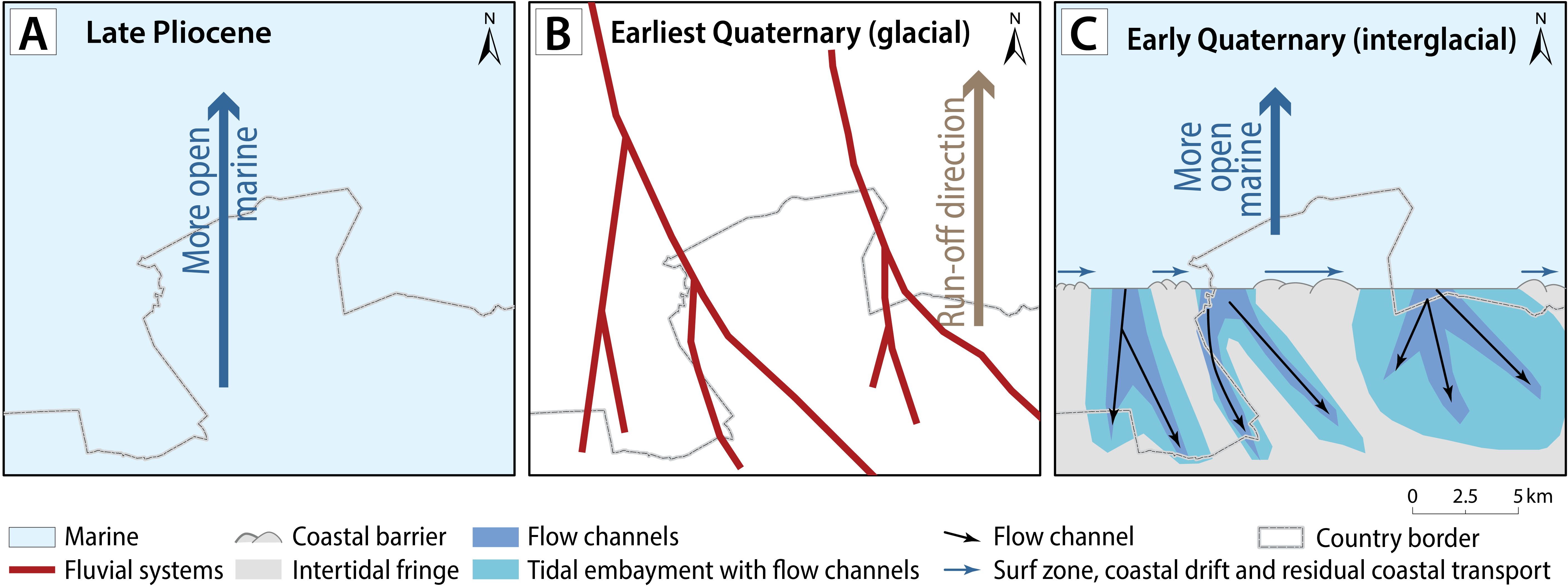
Figure 9. Schematic overview of our hypothesis for the paleogeography of the study area during the late Pliocene deposition of the Merksem Member (A), the earliest Quaternary glacial sea-level lowstand with fluvial incisions and no deposition (B), and the subsequent early Quaternary inter-glacial transgression of the fluvial incised valleys that developed into tidal channels (flow channel) with the deposition of the Merksplas Formation (C).
5.2. Paleogeographic reconstruction
24The incisions at the base of the Merksplas Formation likely initiated as river incisions during early Quaternary subaerial exposure of the Pliocene or now-disappeared earliest Quaternary strata (Fig. 9B). The drainage of these rivers towards the topographic lower areas further north in the southern North Sea Basin could explain the overall N-S trend of the channels as modeled by Vernes et al. (2023), but the latter authors stress that the orientation of the channels remains uncertain due to the relatively low data coverage. The infill of the channel in borehole Huijbergen comprises marine mollusks and dinocysts (Everaert et al., 2023), which indicates that the channels cannot be completely fluvial, but a significant marine component needs to be present. During one or more interglacial sea-level highs, the sea may have invaded the pre-existing fluvial valleys, enlarging them into wider inlets, and may have imported coastal-marine sediments. As the mollusk associations in the Merksplas Formation are indicative of interglacial conditions, the Merksplas Formation also could have been deposited during an interglacial stage, although this remains uncertain as the fossils are reworked (Everaert et al., 2023).
25Most likely, as has been observed in many of the Cenozoic coastal and inner-shelf sediments of the southern North Sea (e.g. Slupik et al., 2007), the sea was tidal and, at rising and high sea level, fringed by intertidal areas (Fig. 9C). If correct, the basal surface of the Merksplas Formation might represent a tidal ravinement surface. Tidal incursion in river mouths under rising sea levels tends to widen these into estuaries. The fill of the incised valleys is then probably also tidal. Unfortunately, we have no observations of the large-scale sedimentary structure in the study area other than the short seismic lines near Roosendaal. East of the study area, in the subsurface of geological map sheet Turnhout-Meerle, the type and structure of sediments in undisturbed cores of the Merksplas Formation indeed provided indications for channel deposition under tidal influence according to Bogemans (1994). This author described a basal sand facies holding shell debris and occasionally showing trough cross-bedding and scour and fill structures, filling depressions scoured into the Lillo Formation. This facies is superposed by a second sand facies containing coarse, sometimes gravelly sand, massive or cross-bedded, with occasional flasers and thin clay or silt layers and peaty fragments. Bogemans (1994) attributed both facies to estuarine depositional environments, one situated more towards the marine domain and the other more towards the fluvial reach of the estuary.
26In the present study area, some other observations corroborate a marginal marine or tidal inlet fill interpretation of the Merksplas Formation. The sorting of the sand in the Merksplas Formation is poor (Fig. 4), which excludes deposition under direct wave action. The overall fining-up trend, while poor sorting is maintained, typifies (tidal) channel fills. The base of the channels and, to a lesser degree, their fill contain coarse elements such as small pebbles, quartz granules, bioclasts, clay pebbles, wood fragments, which are characteristic of (tidal) channel fills. The Quaternary shell gravel present in borehole Huijbergen is a typical sedimentological concentration (Kidwell et al., 1986). The shells are poorly preserved (Everaert et al., 2023): fragmentation and clear abrasion testify to a high-energy environment affected by repeated reworking and physical destruction over a prolonged period of time (e.g. Fürsich & Oschmann, 1993). Different shell colors, ranging from white to light blue and red brown, are indicative of different preservation conditions, before currents and physical reworking created the final biofabric. All these characteristics, together with the geometrical evidence for channels, allow interpretation as channel lag deposits. The observation that possibly intraformational channel scours and fills (intraformational shell bed in borehole Woensdrecht) are present is another argument. Most of the sediment grains in the fill are well-rounded quartz grains (fig. 3a in Everaert et al., 2023), indicative of mature sand typically found in the surf zone. This texture therefore supports a fill mainly sourced from beach and shoreface sand and fed from the open seashore into the drowned valley environment by coastal drift and tidal currents (Fig. 9C). This imported sediment would have been mixed locally and over varying thicknesses (up to 10 m in borehole Essen-Centrum; Fig. 6) with local-sourced clasts, depending on the tidal channel action. If correct, the Merksplas Formation probably shows an internal lateral progradation structure, with channels shifting in the same direction as the coastal drift and tidal currents outside the drowned valley basin. However, such a large-scale internal structure remains to be shown.
6. Conclusions
27Borehole log correlations across the Belgian-Dutch border area indicate erosion at the very coarse base of the Merksplas Formation into the fine sand and clay of the Lillo Formation. According to these boreholes, erosion removed up to 15 m of the upper, sandy part of the Lillo Formation, locally even removing the entire Merksem Member. Interpretation of a high-resolution seismic line in the area shows that locally also the subjacent Kruisschans Member was removed by erosion, and that the total amount of erosion thus exceeds the abovementioned 15 m. Based on the irregular depth of erosion between closely spaced boreholes in two correlation panels and the seismic line, we presume it was caused by channel incision. An effort was made to map the channel incisions in the base of the Merksplas Formation, but the borehole and seismic density are too low to be certain of any channel orientations. Both the incised channels and the inter-channel highs were covered by the deposits of the Merksplas Formation. Within the channels, the Merksplas Formation is thicker compared to the inter-channel highs, which is indicative of channel infill. The bulk of the infill consists of rounded quartz grains, typical of the surf zone. The fauna is marine. All this, and the admixture of very coarse, poorly sorted clastic elements and plenty of reworked material (e.g. fragmented and rounded shells, wood, gravel…), testifies to deposition under strong, tidal or tidally modulated currents. A recent biostratigraphic study of a borehole in the study area showed that the shells are of early Quaternary age (Gelasian). It is our hypothesis that paleo-valleys were cut into the top of the Lillo Formation during one or more sea-level lowstand(s) during the earliest Quaternary. During one or more subsequent interglacial sea-level rise(s), tidal currents entered the paleo-valleys and widened them, depositing a channel lag with shells and other intraclasts, resulting in the current geometry of the base of the Merksplas Formation in the Belgian-Dutch border area. The channel lag deposits of the basal Merksplas Formation are overlain by a thicker, fining-upward sequence, which is indicative for channel fills.
Acknowledgments
28This article is largely based on interpretations and insights acquired during the execution of the H3O-De Voorkempen project by Vernes et al. (2023), with further updates based on the recent article of Everaert et al. (2023). The H3O-De Voorkempen project delivered a seamless, cross-border 3D (hydro)geological model of the Noorderkempen (Flanders) and the western part of Noord-Brabant (The Netherlands); it was carried out by a partnership between TNO-Geological Survey of the Netherlands (GSN), VITO and RBINS-Geological Survey of Belgium (GSB), with financial support from the Flemish Bureau for Environment and Spatial Development (VPO), Flanders Environment Agency (VMM), the Province of Noord-Brabant, drinking water company Brabant Water, GSN and GSB. We are grateful to the H3O project team and steering committee for the fruitful collaboration and discussions that helped improve our understanding of the Cenozoic geology of this cross-border area. Katleen van Baelen (VITO) is thanked for her excellent work on the figures of this article. Reviews by Marc de Batist and Noël Vandenberghe led to significant improvements in the article.
Author contribution
29Jef Deckers conceptualized the research strategy and made the borehole interpretations and correlation together with Jan Walstra and Armin Menkovic. Armin Menkovic provided the seismic line and its existing interpretations. Stijn Everaert provided information on the mollusks found in the base of the Merksplas Formation as observed in the Huijbergen borehole. Rik Houthuys conceptualized the most likely sedimentary processes to explain the channel formation. All authors took part in the writing of the paper.
Data Availability
30The borehole data that support the findings of this study are openly available via https://www.dov.vlaanderen.be/data/opdracht/2024-043168.
References
31Bogemans, F., 1994. Technisch verslag bij de Quartairgeologische kaart. Kaartblad 2-8 Meerle - Turnhout. Ministerie van de Vlaamse Gemeenschap, ANRE, Brussel, 102 p.
32Bogemans F., 1997. Toelichting bij de Quartairgeologische kaart [van België, Vlaams Gewest]: kaartblad 1 - 7, Essen - Kapellen. [1/50 000]. Vlaamse Overheid, Dienst Natuurlijke Rijkdommen, Brussel, 38 p.
33Dearing Crampton-Flood, E., Noorbergen, L.J., Smits, D., Boschman, R.C., Donders, T.H., Munsterman, D.K., ten Veen, J., Peterse, F., Lourens, L. & Sinninghe Damsté, J.S, 2020. A new age model for the Pliocene of the southern North Sea basin: a multi-proxy climate reconstruction. Climate of the Past, 16/2, 523–541. https://doi.org/10.5194/cp-16-523-2020
34Deckers, J., De Koninck, R., Bos, S., Broothaers, M., Dirix, K., Hambsch, L., Lagrou, D., Lanckacker, T., Matthijs, J., Rombaut, B., Van Baelen, K. & Van Haren, T., 2019. Geologisch (G3Dv3) en hydrogeologisch (H3D) 3D-lagenmodel van Vlaanderen. Studie uitgevoerd in opdracht van het Vlaams Planbureau voor Omgeving, departement Omgeving en de Vlaamse Milieumaatschappij. VITO, Mol, VITO-rapport 2018/RMA/R/1569, 286 p. https://dov.vlaanderen.be/page/geologisch-3d-model-g3dv3, access 01/12/2023.
35Deckers, J., Louwye, S. & Goolaerts, S., 2020. The internal division of the Pliocene Lillo Formation: correlation between Cone Penetration Tests and lithostratigraphic type sections. Geologica Belgica, 23/3-4, 333–343. https://doi.org/10.20341/gb.2020.027
36De Meuter, F.J. & Laga, P.G., 1976. Lithostratigraphy and biostratigraphy based on benthonic foraminifera of the Neogene deposits in Northern Belgium. Bulletin van de Belgische Vereniging voor Geologie/Bulletin de la Société belge de Géologie, 85, 133–152.
37De Schepper, S., Head, M.J. & Louwye, S., 2009. Pliocene dinoflagellate cyst stratigraphy, palaeoecology and sequence stratigraphy of the Tunnel-Canal Dock, Belgium. Geological Magazine, 146/1, 92–112. https://doi.org/10.1017/S0016756808005438
38Everaert, S., Deckers, J., Munsterman, D. & Wesselingh, F., 2023. The Pliocene–Pleistocene transition in the subsurface of the Dutch-Belgian border region: insights from borehole Huijbergen. Geologica Belgica, 26/1-2, 25–40. https://doi.org/10.20341/gb.2023.001
39Fürsich, F.T. & Oschmann, W., 1993. Shell beds as tools in basin analysis: the Jurassic of Kachchh, western India. Journal of the Geological Society, 150, 169–185. https://doi.org/10.1144/gsjgs.150.1.0169
40Gibbard, P.L., 1988. The history of the great northwest European rivers during the past three million years. Philosophical Transactions of the Royal Society of London B, 318, 559–602. https://doi.org/10.1098/rstb.1988.0024
41Gibbard, P.L. & Lewin, J., 2003. The history of the major rivers of southern Britain during the Tertiary. Journal of the Geological Society, 160/6, 829–845. https://doi.org/10.1144/0016-764902-137
42Gibbard, P.L. & Lewin, J., 2016. Filling the North Sea Basin: Cenozoic sediment sources and river styles. André Dumont medallist lecture 2014. Geologica Belgica, 19/3-4, 201–217. https://doi.org/10.20341/gb.2015.017
43Gulinck, M., 1962. Essai d’une carte géologique de la Campine. Etat de nos connaissances sur la nature des terrains néogènes recoupés par sondages. Mémoires de la Société belge de Géologie, de Paléontologie et d’Hydrologie, série in-8°, 6, 30–39.
44Gullentops, F., Bogemans, F., De Moor, G., Paulissen, E. & Pissart, A., 2001. Quaternary lithostratigraphic units (Belgium). Geologica Belgica, 4/1–2, 153–164. https://doi.org/10.20341/gb.2014.051
45Gunnink, J.L., Maljers, D. van Gessel, S.F., Menkovic, A. & Hummelman, H.J., 2013. Digital Geological Model (DGM): a 3D raster model of the subsurface of the Netherlands. Netherlands Journal of the Geosciences – Geologie en Mijnbouw, 92/1, 33–46. https://doi.org/10.1017/S0016774600000263
46Halet, F., 1933. Observations nouvelles sur l’âge des dépôts dits amstéliens de la partie septentrionale de la Campine anversoise. Bulletin de la Société belge de Géologie, de Paléontologie et d’Hydrologie, 43, 394–409.
47Hummelman, H.J., Maljers, D., Menkovic, A., Reindersma, R., Stafleu, J. & Vernes, R.W., 2019a. Totstandkomingsrapport Digitaal Geologisch Model (DGM). TNO - Geologische Dienst van Nederland, Utrecht, TNO-rapport 2019 R 11653, 70 p.
48Hummelman, H.J., Maljers, D., Menkovic, A., Reindersma, R., Stafleu, J. & Vernes, R.W., 2019b. Totstandkomingsrapport Hydrogeologisch Model (REGIS II). TNO - Geologische Dienst van Nederland, Utrecht, TNO-rapport 2019-R11654, 95 p.
49Jacobs, P., Polfliet, T. & Moerkerke, G., 2010. Toelichting bij de geologische kaart van België, Vlaams Gewest: kaartblad 1 – 7, Essen – Kapellen. [1/50 000]. Belgische Geologische Dienst en Departement LNE, Afdeling Land en Bodembescherming, Ondergrond, Natuurlijke Rijkdommen, Brussel, 44 p.
50Jakob, K.A., Wilson, P.A., Pross, J., Ezard, T.H.G., Fiebig, J., Repschlager, J. & Friedrich, O., 2020. A new sea-level record for the Neogene/Quaternary boundary reveals transition to a more stable East Antarctic Ice Sheet. Proceedings of the National Academy of Sciences of the United States of America, 117/49, 30980–30987. https://doi.org/10.1073/pnas.2004209117
51Kidwell, S.M., Fürsich, F.T. & Aigner, T., 1986. Conceptual framework for the analysis and classification of fossil concentrations. Palaios, 1, 228–238. https://doi.org/10.2307/3514687
52Knox, R.W.O’B., Bosch, J.H.A., Rasmussen, E.S., Heilmann-Clausen, C., Hiss, M., De Lugt, I.R., Kasińksi, J., King, C., Köthe, A., Słodkowska, B., Standke, G. & Vandenberghe, N., 2010. Cenozoic. In Doornenbal, J.C. & Stevenson, A.G. (eds), Petroleum Geological Atlas of the Southern Permian Basin Area. EAGE Publications b.v., Houten, 211–223.
53Laga, P., 1972. Stratigrafie van de mariene Plio-Pleistocene afzettingen uit de omgeving van Antwerpen met een bijzondere studie van de foraminiferen. Unpublished Ph.D. thesis, KU Leuven, Leuven, 252 p.
54Louwye, S., Deckers, J. & Vandenberghe, N., 2020. The Pliocene Lillo, Poederlee, Merksplas, Mol and Kieseloolite Formations in northern Belgium: a synthesis. Geologica Belgica, 23/3-4, 297–313. https://doi.org/10.20341/gb.2020.016
55Matthijs, J., Lanckacker, T., De Koninck, R., Deckers, J., Lagrou, D. & Broothaers, M., 2013. Geologisch 3D lagenmodel van Vlaanderen en het Brussels Hoofdstedelijk Gewest - versie 2, G3Dv2. Studie uitgevoerd door VITO in opdracht van de Vlaamse overheid, Departement Leefmilieu, Natuur en Energie, Afdeling Land en Bodembescherming, Ondergrond, Natuurlijke Rijkdommen, Mol, VITO-rapport 2013/R/ETE/43, 21 p. https://archief.onderzoek.omgeving.vlaanderen.be/Onderzoek-2317920, accessed 28/12/2022.
56Meekes, J.A.C., 1998. Hoge Resolutie Seismiek Roosendaal, Kartering Kleiafzettingen van de Formatie van Tegelen. TNO - Geologische Dienst van Nederland, Utrecht, TNO-rapport NITG 97-296-B, 24 p.
57Pluymaekers, M.P.D., Doornenbal, J.C. & Middelburg, H., 2017. Velmod-3.1. TNO - Geologische Dienst van Nederland, Utrecht, TNO-report R11014, 67 p. https://www.nlog.nl/sites/default/files/2018-11/060.26839%20R11014%20with%20erratum%20page%2067%20Doornenbal-final.sec_.pdf, accessed 28/12/2022.
58Slupik, A.A., Wesselingh, F.P., Janse, A.C. & Reumer, J.W.F., 2007. The stratigraphy of the Neogene-Quaternary succession in the southwest Netherlands from the Schelphoek borehole (42G4-11/42G0022) – a sequence-stratigraphic approach. Netherlands Journal of Geosciences – Geologie en Mijnbouw, 86/4, 317–332. https://doi.org/10.1017/S0016774600023556
59Stafleu, J., Hummelman, J., de Bruijn, R., Koster, K., Stam, J., Maljers, D. & Schokker, J., 2020. Totstandkomingsrapport GeoTOP – met nieuwe methodiek lagenmodellering. TNO - Geologische Dienst van Nederland, Utrecht, TNO-rapport 2020 R10758, 157 p. https://www.broloket.nl/sites/default/files/docs/geotop/R10758%20Totstandkomingsrapport%20GeoTOP%20-%20met%20nieuwe%20methodiek%20lagenmodellering.pdf, accessed 28/12/2022.
60Thöle, H., Gaedicke, C., Kuhlmann, G. & Reinhardt, L., 2014. Late Cenozoic sedimentary evolution of the German North Sea – a seismic stratigraphic approach. Newsletters on Stratigraphy, 47, 299–329. https://doi.org/10.1127/0078-0421/2014/0049
61TNO, 2003. Geologische Atlas van de Diepe Ondergrond van Nederland, Toelichting bij de kaartbladen XI en XII Middelburg - Breskens en Roosendaal - Terneuzen. Nederlands Instituut voor Toegepaste Geowetenschappen TNO - Geologische Dienst Nederland, Utrecht, 107 p.
62Vernes, R.W., Deckers, J., Walstra, J., Kruisselbrink, A.F., Menkovic, A., Bogemans, F., De Ceukelaire, Dirix, K., Dusar, M., Hummelman, H.J., Maes, R., Meyvis, B., Munsterman, D.K., Reindersma, R., Rombaut, B., Van Baelen, K., van de Ven, T.J.M., Van Haren, T. & Welkenhuysen, K., 2023. Geologisch en hydrogeologisch 3D model van het Cenozoïcum van de Belgisch-Nederlandse grensstreek van De Noorderkempen/West-Brabant (H3O-De Voorkempen). TNO, Geologische Dienst Nederland, Utrecht, VITO; Vlaams Instituut voor Technologisch Onderzoek, Mol; Belgische Geologische Dienst van het Koninklijk Belgisch Instituut voor Natuurwetenschappen, Brussel; TNO-rapport 2023 R10347 – VITO-rapport 2023/RMA/R/2906 – BGD-rapport 2023/02, 149 p. https://www.dov.vlaanderen.be/sites/default/files/pfiles_files/R10347%20H3O_De_Voorkempen_eindrapport_v5_ondertekend.mb3_.pdf, accessed 28/12/2022.
63Vervoenen, M., 1995. Taphonomy of some Cenozoic seabeds from the Flemish region, Belgium. Service géologique de Belgique, Professional Paper, 272, 1–115.
64Westerhoff, W.E., 2009. Stratigraphy and sedimentary evolution: The lower Rhine-Meuse system during the Late Pliocene and Early Pleistocene (southern North Sea Basin). Ph.D. Thesis, Vrije Universiteit Amsterdam, Amsterdam, 168 p.
65Manuscript received 28.11.2023, accepted in revised form 01.10.2024, available online 15.05.2025.
