


- Portada
- 79 (2022/2) - Varia
- Socialist agricultural villages in Sersou (Western Algeria) rural areas’ modernization with urban landmarks


Vista(s): 3118 (4 ULiège)
Descargar(s): 134 (0 ULiège)

Socialist agricultural villages in Sersou (Western Algeria) rural areas’ modernization with urban landmarks

Documento adjunto(s)
Version PDF originaleRésumé
Le Sersou, le grenier à blé dans l’Ouest algérien et la zone la plus dynamique de la wilaya de Tiaret, a vu son réseau urbain s’agrandir sous l’effet de la croissance démographique et du développement aussi bien industriel qu’agricole. Son espace s’est densifié par une douzaine de « villages socialistes agricoles » dans les années 1970, dans le cadre d’une politique nationale de modernisation et de développement rural, ̎ la révolution agraire ̎. Ces villages agricoles étaient construits pour soutenir le travail de la terre et améliorer les conditions de vie des populations rurales.
Cette contribution veut revisiter ces villages après plus d’une quarantaine d’années d’existence pour voir comment ils sont organisés, appropriés et insérés dans le réseau urbain. Elle veut également analyser à travers cet exemple l’aboutissement d’une politique de modernisation de la campagne algérienne qui a suscité autant de débats et critiques dès sa mise en œuvre.
Abstract
The Sersou, the granary of wheat in western Algeria and the most dynamic area of the state (wilaya) of Tiaret, has seen its urban network expand under the effect of population growth and industrial as well as agricultural development. Its space was densified, by a dozen "agricultural socialist villages" in the 1970s. As part of a national policy of modernization and rural development, ̎ the agrarian revolution ̎. These agricultural villages were built to support the work of the land and improve the living conditions of rural populations.
This contribution wants to revisit these villages after more than forty years of existence to see how they are organized, appropriated and inserted into the urban network. It also wants to analyze through this example the outcome of a policy of modernization of the Algerian countryside, which has aroused so much debate and criticism since its implementation.
Tabla de contenidos
INTRODUCTION
1Algeria, like other countries in this region, is not new to this phenomenon. Indeed, the latter has been the fruit of numerous, successive civilizations, but has been limited, solely, to certain areas of the national territory, However, in the past forty years, an explosion of urbanization disrupted the landscape (environment), individuals’ mindsets, and society itself (Côte, 1994). Indeed, the rate of urbanization doubled between 1966 and 2008, from 31.4% to 65.9%. Rural housing has developed as a model of settlement in rural areas. Whether aggregated or dispersed in Algeria through various historical stages, shapes and designs have also evolved by adapting to the local environment and specificities. Indeed, rural housing in the villages of Kabylie is different from that of the Aures (chawi) as well as in the plains and desert. This development is not only concerned with Algeria, most countries in the world have witnessed this change due to the high wave of urbanization.
2Many villages for settlers have been erected in Algerian rural areas since the colonial period to support ever-changing agricultural activity. This was done in parallel with the agricultural reform policy that most countries of the world experienced in the 18th and 19th centuries, which allowed for the modernization and development of villages, which prompted many families to settle in the fields, especially in Europe (Switzerland and Denmark). Many of these villages evolved in the 20th century into small service centers, with craftsmen and shops for everyday necessities (Christiansen, 2020).
3Algeria has adopted an important program of modernization and development of its rural world, known as the "agrarian revolution". Thus, translating the socialist orientation of the independent Algerian state, which called for the abolition of individual property as an unfair system that does not allow for the well-being of society? This has been compensated by collective and public property according to the slogan "Land for those who work it" (Houchine, 2007). Rural housing was considered one of the major pillars of the agrarian revolution, as it was considered an essential tool for planning the Algerian territory (Le Coz, 1979).
4To achieve this goal, an exceptional program has been planned, namely the construction of 1000 participatory villages approved in 1973 following the National Forum on Rural Housing. The latter included support for a new rural planning model with long-term objectives (Lesbet, 1983).
5The Sersou region in western Algeria benefited from twelve socialist villages, which were completed between the mid-1970s and the early 1980s. This region is characterized by its great natural potential, its economic specificity which is mainly a cereal region and the most dynamic one in the state of Tiaret.
6Through this article, we will evaluate and analyze the results of this project to modernize the Algerian countryside, which has generated a lot of controversy and criticism since its creation, by studying the Sersou region, more than forty years after the completion of these villages. We will also try to understand how these villages have evolved, what is their functional role and to what extent they are integrated into the urban network of Sersou?
I. STUDY AREA AND RESEARCH METHODOLOGY
A. The Sersou, multiple potentials
7The Sersou plain, which is located in the High Plains (Western Algeria), placed at 300 km south of the capital Algiers and 250 km southeast of Oran City, at an average altitude of approximately 950 m above sea level. With an average height of about 950 meters, is a wide band, which extends longitudinally from East to West of about 237 Km and is approximately 37 km long. San area is about 8,700 square kilometers, located north of the foothills south of Ouarsenis and south by two important mountain blocks, Nador and Sidi Abed.
8Nahr Ouassel, heavily structures the east part. Average rainfall in the region ranges from 250 to 500 mm and decreases from north to south, which is considered suitable for growing cereals.
9The Sersou is located on three large pockets of groundwater with large areas (Sersou, Ouassel and Mina). Two dams collect some of the surface water on the banks of the Ouassel Valley (Nahr Ouassel) (Bougara, Dahmouni).
10The quality of the Sersou’s soils is varied, ranging from rich to light and mixed (Perrin, 1960). These components allowed the cereal crop to develop significantly until the name of the Sersou is associated with it, but this area is also considered a breeding area and is currently experiencing a diversification of agricultural production.
11The Sersou is located administratively and mostly in the state of Tiaret and to a lesser extent in the state of Tissemsilt (Figure 1). Its location made it a meeting point between the steppe plains of the south, and the hill in the north, and an axis in which many national roads gather (14-23-40-90). The most important is the national road No. 14, which structures the southwestern and northern parts. It connects Tiaret to Algiers the capital of the country, while the national road No. 40, built the central part. The Sersou has a dense local road network, including the wilaya roads (1-3-6-7-11-14-16-17-19-77).
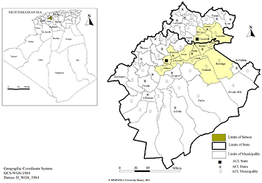
Figure 1. Location of Sersou plain in high Land (western Algeria)
B. Data and methodology
12This research is based on multiple sources: observation and field survey, investigation, interview, statistical and technical data. We conducted a field survey of the urban fabrics of the socialist villages in order to determine the use of the land, its development, and the level of equipment and housing designs. Participatory observation with the elderly helped us to know the conditions of the emergence of villages, and with another number of residents in understanding the motives for the urban expansion of the agricultural villages and the strategies adopted by the residents.
13We also conducted a direct and indirect survey with 270 Households distributed over nine villages out of twelve carried out in 2021. We investigated the form directly with several heads of families, most of whom were men, chosen at random. We also based on an indirect survey, where we distributed the same form to several Primary school students to be filled out by their parents. The questionnaire consists of a mixture of closed, and open-ended multiple-choice questions. It touched on several aspects related to the number of families and their social characteristics (geographical origin, throne), population movements and their motives, housing and equipment, the changes that affected it, and the professions practiced by both genders and their transformations. The field survey results were used and distributed according to the logical sequence of the article content. We also conducted a dozen semi-directed interviews with the residents of the villages and managers (heads of administrative departments, elected, and carriers...) to find out the functional relationships of these villages and the extent to which their residents integrate into their surroundings (frequency and reasons for daily travel, role of small centers, relationships with cities, planning and management, social life...). We also relied on the data of the general population and housing censuses for the period from 1966 to 2008, from National Office of Statistics (ONS), and the data of the technical interests and the preparation and reconstruction plans (development and urban planning master plans, land use plans, urban coordination plan, and state (Wilaya) development plans). To facilitate the approach to the reconstruction of the Sersou area and to understand its mechanisms, the statistical processing of the data was carried out using the Excel program, while the thematic mapping was based on the program MapInfo.
14The breadth of the study area and the scattering of its villages created difficulties for us during the field survey, such as the absence of the head of the family in the morning period, forcing us to visit the villages many times. Many of the answers to the questions asked through the indirect survey were not retrieved because they were incomplete or not understood. Enough. In addition, the absence of archives for a number of villages prompted us to update the plans by relying on the Google Earth (Image 2006-2019 Digital Globe), and field surveys.
II. SERSOU URBANIZATION: MULTIPLE MECHANISMS AND CONTINUED POPULATION GROWTH
15Before the arrival of French colonialism, the region of Sersou was sparsely populated and sparsely urbanized, characterized mainly by its rural and pastoral aspect. The colonial system’s interest in ceremonial culture paved the way for the rapid urbanization of the Sersou plain. This embryonic urbanization was intended for the settlement of the first settlers, which helped to bring out a duality between the traditional, dispersed and modest urban space, and the new colonial space different from the culture and sociology of the local rural world (Fekar, 2013).
16The urbanization of the Sersou has spread mainly along National Highway 14, which has led to the creation of a multitude of urban centers 15 km apart. The result of this colonial urbanization was the creation of 15 urban centers, in addition to the 15 centers that were built for the local tribes (Figure 2). The presence of so many urban centers in the middle of such an area as the Sersou was not due to chance, this urbanization was voluntary and its economic purpose in order to allow the exploitation of fertile agricultural land.
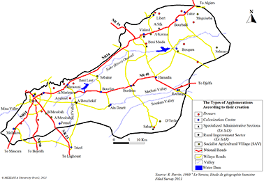
Figure 2. Urbanization in Sersou
17This intensive urbanization has led to significant population growth in Sersou, with a population volume of more than 91 000 in 1957 and an average growth rate of 1.7% over the period (1884-1957), while Tiaret recorded a much higher rate (3%). Since the colonial period, the population of Sersou has increased sevenfold, reaching 615 138 in 2019. The population growth rate remained high from 1966 to 1998 (3.6%). In 2008, it decreased (1.6%), rising again (2.2%). This population is distributed mainly, at the level of a number of large cities that structure this territory: Tiaret as a large main center (245 929 inhabitants), followed by Tissemsilt in second place (100 697 inhabitants). These two cities are both the capital of state (wilaya) and have a role of framing the territory of their state, followed by second-level centers such as Mahdia (37 222), Khemisti (24 580) and smaller towns of different sizes.
18It is clear that the high annual rate of population growth (4.2%) during the decade 1977 and 1987, was due to the creation of socialist villages, which led not only to the sedentary population of the nomadic population, but also to the polarization of rural populations and urban groups in and out of Sersou.
19This phase is seen as a period of economic and social and Algerian restructuring, aimed at improving operating conditions, better controlling the production apparatus, improving the functioning of the inherited system and particularly influencing the organizational aspects of all sectors. (Arecchi and Megdich, 1979; Kasdallah, 2013). The state continued in the same previous political vision, in the agricultural sector. To integrate the rural world into the national development process, through the "agricultural revolution", the aim of giving back land to farmers, and modernizing agriculture on the basis of two principles: production units of "Land to those who work it", and the housing centers represented by the construction of socialist villages in the early 1970s. The land and means of production were obtained through two mechanisms: judicial and political by nationalization, economic through the creation of service cooperatives and the development of agricultural credit policy, these mechanisms have enabled the State to recover more than one million hectares of arable public land as part of this reform. Also 537167 hectares of private sector land (9% of its total land) was nationalized and about 2% of the total property identified (21826 owners) was nationalized.
20More than 6000 cooperatives of all types have been established (Bessaoud, 1980), including 4056 production cooperatives from the Agricultural Revolution (Gauthier, 1980). This type of cooperative has benefited from about 80% of the best agricultural land and has included almost two-thirds (65%) beneficiaries of the exploitation of development lands.
21These villages are considered an important urbanization mechanism that Sersou has experienced, with 12 villages completed in the 1970’s and early 1980’s. They were mainly concentrated on the south bank of the Ouassel River, which structures much of the Sersou, where the region is made up of rich productive agricultural plains. The socialist villages restored the principle of the distribution of the population throughout the Sersou region and created a kind of balance, although the settlement along the roads prevailed in this distribution.
22The socialist villages attracted the inhabitants of Sersou, sedentary or semi-nomadic, small farmers, and landless, as well as by peasants and herders from the steppe region south of Sersou. The tribes of Larba and Ouled Nail from Laghouat and Djelfa abandoning their old and modest earth dwellings and settling in the plain, to offer their experience in livestock for self-managed agricultural estates (Duvigneau, 1986).
23The population of the socialist villages represented 5.9% of the population of Sersou in 1977. It doubled to 12% in 2008 (45173 Inhabitants), if we exclude the population of the two main settlements namely Tiaret and Tissemsilt the proportion of the population of these villages rises to 19%.
24The population, growth record in Sersou is concentrated according to the different censuses of the population in the secondary agglomerations, and this in a majority of municipalities that have recorded high increases, especially the socialist villages, with a growth rate of 7.9% in 1977-1987, while it declined to 3.7% in the following period (1987-1998). This does not prevent it from remaining higher than the rate recorded in the region of Sersou, the state of Tiaret as well as the country. The socialist villages have helped to reduce the size of the sparse population of Sersou, the growth rate of the Sersou is negative and is estimated to -0.3% during the period 1977-1987, encouraged by the promotion of some of these villages in common by administrative redistricting of 1984 (Ain Bouchekif, Sebaine, Nadorah, Bougara and Rechaiga).
25The large urban centers and small towns of Sersou maintained their demographic dynamism between 1987 and 1998, as did Tiaret (4%) Tissemsilt (6.3%), Hamadia (6.9%), Laayoune (7.0%) (Figure 3). The area remained populated and even attractive, as it concentrated the main activities (agriculture, industry and service). Sersou has benefited from significant investments in various sectors, such as the creation of industrial zones and other activities that have attracted domestic industrial units and medium-sized production units.
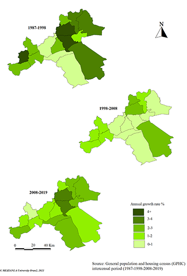
Figure 3. Population growth rate according to the municipalities of Sersou
26The rate of population growth decreased during the period 1998-2008, with an annual growth rate of only 1.6% in the entire Sersou region, the rate recorded in socialist villages is 1.8%. These rates are lower than the national average (2.3%) but higher than that of the Tiaret state (1.5%), although the gross birth rate in the state of Tiaret increased (24.7% in 1998 to 26.99 in 2008). This is due to migration out of the state, where the balance migration during this period was negative (-116,924 in 1998-2008), net external net migration also recorded a negative value (8,953 departures in 1998-2008), due to difficult economic conditions resulting from the closure of many economic units.
27Population growth increased over the period (2008-2019) with an annual growth rate in the state of Tiaret higher than the previous period (2.0%) This is due to immigration to the state, since the birth rate during this period has not changed much from the previous one (2.7%).
III. VOLUNTARY URBANIZATION, NEW URBAN STRUCTURES AND NEW DESIGNS
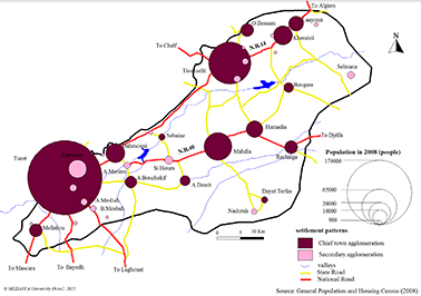
28The number of settlements1 in Sersou increased from 16 in 1966 to 21 in 1977 due to the completion of four socialist villages (classified as secondary settlements), the urban network densified in 1987 and reached 27 settlements. Five new municipalities also reinforced the administrative network, while the number was 10 during the previous period. The number of agglomerations increased to 36 in 2008 (Figure 4 and Table 1). Some of the towns in Sersou have changed rank and size. In fact, the Mahdia agglomeration went from semi-urban to urban in 1977, while the agglomerations of Mellakou, Ain Bouchekif, and Ouled Bessem have gone from semi-rural to semi-urban in 2008. we note that there is a disparity in the spatial distribution of the population with a clear evolution in the administrative centers, in the face of the depopulation of small agglomerations (Côte, 2011). The settlements of Rechaiga, Ain Dzarit and Si Haouas have gone from rural to semi-rural status still in 2008.
29
Figure 4. Population distribution in Sersou according to the settlement pattern in 2008
|
Population censuses |
Chief town agglomeration (ACL) |
Secondary agglomeration (S.A) |
Agglome-rated populations |
Dispersed populations |
Total population |
Number of agglomerations |
Number of SAV |
||
|
Number |
Population |
Number |
Population |
||||||
|
1966 |
10 |
70028 |
6 |
5030 |
75058 |
52708 |
127766 |
16 |
0 |
|
1977 |
10 |
106281 |
11 |
16076 |
122357 |
54984 |
177341 |
21 |
7 |
|
1987 |
15 |
191257 |
12 |
18759 |
210016 |
66325 |
276341 |
27 |
10 |
|
1998 |
15 |
314683 |
13 |
35460 |
350143 |
60260 |
410403 |
28 |
12 |
|
2008 |
15 |
378081 |
21 |
44667 |
422748 |
59422 |
482170 |
36 |
12 |
Table 1. The growth of urban agglomerations in Sersou (1966-2008). Source: National Statistics Office (1966-1977-1987-1998-2008)
30Twelve socialist villages, created as space units in two types, densified the urban network of Sersou: new Ex Nihilo village, Sebaine, Ain Meriem, Biban Messbah, Ain Messbah and Selmana on the south shore of Nahr Ouassel, Meguissba and Ain Karma on its north shore. The other is included in or near an ancient fabric in number of five (Seraidi, Ain Bouchekif, Rechaiga, Ouancharis El-Beida and Dayat Terfas).
31These villages have been established on public land in the middle of productive agricultural land, along national roads, making access easier. However, some villages were established on sites where problems were later raised regarding their frequent exposure to floods such as Dayat Terfas and Rechaiga (Lesbet, 1983).
32The socialist villages were created according to a model inspired by the life through designs, a style of housing, urban facilities and infrastructure according to a logic completely different from what is traditional and customary in the Algerian countryside. This model translates an urban organization in the villages with a regular layout of the habitat and hierarchical roads network inspired by modern architecture. The design was the work of international architects such as Ricardo Bofill. Several models were adopted which respect the principle of alignment of buildings, the hierarchy of roads and the separation between different functions (residential, equipment, agriculture).
33One of the main design models adopted for the socialist villages of Sersou was the star-studded model designed by architect Ricardo Bofill; it is a new model in the territory of Sersou, appliqued in two villages, Ouancharis El-Beida and Ain Meriem on the south bank of Nahr Ouassel. A residential cluster around a circular square that concentrates the facilities characterizes this design; the dwellings are organized around them, separated by circular and radial roads.
34The circular model, which is very similar to the star model, its roads are radio-centric and the dwellings are organized around a central square (Figure 5), This model was applied in four villages (Ain Karma, Biban Messbah, Dayat Terfas and Selmana).
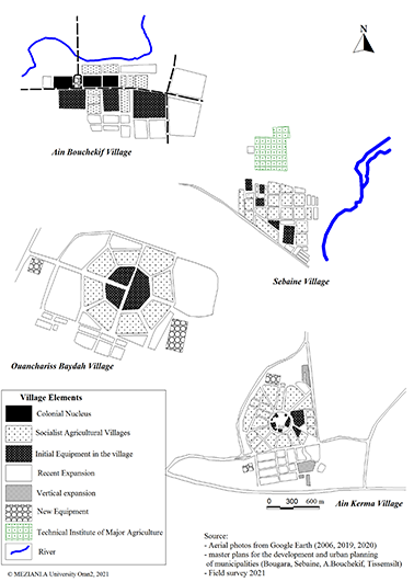
Figure 5. The urban structure of some socialist Agricultural villages in Sersou
35The aim of these two conceptions is to create an identity, to ensure the social life of the villagers and to achieve social harmony in order to integrate new residents from different origins in these villages. This centrality in village design was also intended to allow new comers to reproduce, for example, their behavior in markets (Safar-Zitoun, 1976).
36The checker board design was applied in five socialist villages established near the urban fabrics inherited from the colonial period, such as Seraidi, Ain Bouchekif, and Rechaiga, it was mainly an extension of the existing urban model or in new villages erected in the seventies, such as Ain Messbah and Meguissba.
37The main roads remained the structuring axes of a number of urban fabrics of socialist villages that were equipped by the main basic facilities (school, mosque, treatment room, covered market, post office ...). These architectural models adopted in the establishment of socialist villages have reinforced the mental image of the city among its inhabitants by reducing the mental representation of traditional space, as well as by the urban functions and accompanying facilities offered by these villages.
IV. HOUSING DRIVES TRANSFORMATIONS WITH URBAN CHARACTERISTICS
38The rural area of Sersou has undergone spatial changes due to the urban extensions that have been experienced by the villages, whether colonial or socialist, as a result of the various development and housing programs that have benefited from it. The population growth of these villages has also had a major impact on their changes, such as the increase in the need for housing and equipment on the one hand and their impact on their social structure on the other.
39The role of the road has appeared to us to be crucial in the growth of the agglomerations located on the main roads, which have experienced a much faster extension than the other towns located far from the main roads. These recent extensions of the villages of Sersou to the roads have changed the morphology from the initial one, mainly. It has been designed according to the star model, such as Ouancharis El-Beida, which extended to the old center, resulting in the fusion of the two fabrics and the loss of its beautiful urban form.
40Some settlements, such as Rechaiga, Ain Bouchekif, Selmana and Meguissba, have experienced a longitudinal extension, which has produced linear urbanization along the main roads due to the higher real estate value of the land on these roads as well as to benefit from commercial activities related to heavy road traffic.
41These urban extensions were carried out at different intervals and mechanisms where housing was the main lever. Socialist villages grew slowly in the 1990s, but from the early 2000s on, they began to experience accelerated urban dynamics thanks to the national agricultural development plan and the various housing programs initiated by the state after the financial upswing in the country following the surge in oil prices2. The state of Tiaret benefited from 37,826 rural housing units, or 39.2% of all housing projects (96,392 units under various formulas), a portion was carried out in the form of consolidated rural housing, 3,302 units (8.7%). They have been established in various rural settlements in the Sersou in general (933 regions, or 28.3% of the state quota) and in socialist villages in particular (603 units, or 64.3% of the Sersou quota). The housing programs of all types have contributed to the expansion of socialist villages, which have received more than 24% of the total housing programmer of different formulas (19991 units) allocated to the Sersou region (Figure 6).
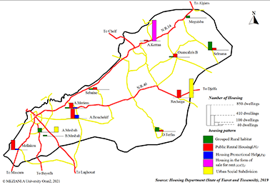
Figure 6. Distribution of housing programs in socialist villages according to the pattern
42The ever-increasing demand for housing at the local level has prompted headquarters to adopt a new formula for rural development and improve their living conditions by grouping applicants into subdivisions established on public domain land so that they can be easily connected to various networks (Wastewater, water drinking, electricity and gas...). As well as equipped or bringing them closer to the various public services such as education, health, etc., it is also a solution for the people leaving the area by encouraging it to settle there or return (Cocaud, 2005).
43However, this mechanism has been diverted from its original purpose and has been exploited to expand the land reserve of some urban settlements and solve their housing problems. Most socialist villages have benefited from the rural housing program, ranging from 50 to 350 dwellings (the village of Selmana has benefited from the largest share of 350 dwellings).
44Some socialist villages near the city of Tiaret have formed satellite settlements by receiving housing projects and their own equipment, consisting of relocation programmers for the inhabitants of precarious neighborhoods (Ain Bouchekif Complex 11.3%), as well as housing programs for workers in the industrial units (SONACOM).
45The village of Ain Messbah received public facilities consisting of a rehabilitation center and police school in the land recovered during the receding of the populations of the anarchic districts. The village also received a residential subdivision program, (218 lots representing 16.6% of the share of Sersou), which benefited the municipality of Tiaret, as part of housing estates in the urban area. In the interest of the inhabitants of the High Plateaus, and the South (five-year plan 2019-2022) were established in the village, although the municipality of Tiaret is not entitled to benefit from this type of subdivision, according to inter-ministerial instruction 01 of 30/09/2020. Since this program only applies to municipalities subject to the High Plateau Fund3, we found from our field survey that more than 54% of the families who changed their homes to the village of Ain Messbah came from the Tiaret metropolitan area.
46The socialist villages have entered in a new phase of urbanization, moving from the village scheme adopted in their creation to a new horizontal and vertical urban model, similar to that found in large urban centers, leading to a degradation of conceptions and the loss of some villages to their architectural peculiarities.
47These transformations have been reflected in social housing programs for urban areas, such as the rental-sale and participatory social formula. The socialist villages have also benefited from this type of housing programmers (18.3% from the Sersou), which have been located in terms of recent extensions along the roads. In response to the growing demand for housing, in the centers of the main settlements such as Rechaiga, Ain Bouchekif, Ouancharis El-Beida, Dayat Terfas and Sebaine, as well as secondary settlements such as Ain Meriem, Ain Al-Karma and Selmana. It also benefited from the urban social subdivision program4 (Figure 6). The towns also benefited from the urban social subdivision program with a total of 997 plots of land (lots de terrain) equivalent to 76.2% of the Sersou share (1309 plots), located mainly in Rechaiga and Ain Messbah, or 14.9% of the 6912 lots benefited from the state of Tiaret.
V. REFRAMING HOUSING: FROM CLOSED TO OPEN STRUCTURE
48Traditional rural housing is considered, the center of all extended family activities. It is characterized by a similar architectural style to the exterior, with small openings and walls deaf exteriors, which often do not have a coating or just a coating with dirt. The houses were closed, and open around an inner space called “El Hawch” (Figure 7), or the central courtyard of the house. The courtyard “El Hawch” is functionally an interior space for the building block and an outdoor space for bedroom and the rest of the rooms. This ensures communication between the different components of the house. The height of its wall outside is generally small. It contains one or more rooms, sometimes depending on the financial situation; each family includes a few items such as warehouse, store, machinery warehouse, fertilizer and various materials…
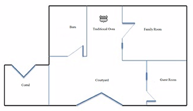
Figure 7. Traditional rural dwelling design (Authors, 2022)
49There is also the so-called “family economy” space, which is managed by women’s (traditional oven, weaving...). Its building materials are removed from the natural environment (Saada and Hmouda, 2020), and are designed holistically derived from the needs of society and not the personal needs of each individual, thus balancing resources and consumption (Selmane, 2017).
50The political policies of the socialist villages of Sersou introduced a new model of housing in a very short period of time (Duvigneau, 1986), in which neither the views nor the needs of the peasants whose homes are their shelter and their means of work have been taken into account (Arecchi and Megdich, 1979).
51This new habitat is characterized by its open structure embodied by large windows and its smaller shape and also by the presence of spaces with a single function such as kitchen, bathrooms, living room, and small courtyards, (Changes in housing design are illustrated in Figure 8). The entrances to the dwellings are smaller than they were in the traditional habitat where it was used to introduce animals and agricultural materials. All the amenities necessary for a modern habitat were introduced such as water, electricity, gas. In addition, sanitation, building materials have gone from clays and stones to cement, brick, reinforced concrete, and brick blocks, which has improved the mental image of the city as an ideal model for all by reducing the mental representation of traditional space and by urban functions in villages (Chabi, 2008).
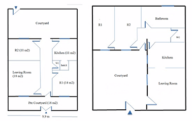
Figure 8. Design of a residence in the socialist village of Ain Meriem and Dayat Al-Terfas (Authors, 2022)
52The family home has lost its function, as a center of activity as it was before, or a hub for the development of its surrounding space. But has become only a center of consumption (Duvigneau, 1986), due to the suppression of its economic functions, such as handicrafts (weaving and traditional food industry), storage and accommodation, as livestock has become forbidden, and incompatible with the modernization of the life of rural populations, or their concentration in the villages. The grouping of the population in these villages has partially emptied the rural area of Sersou of its pastoral function. These new housing designs did not last long. In fact, the inhabitants of socialist villages have modified their interior and exterior spaces according to the requirements and financial capacity of each family, therefore, these attempts cannot be considered only as negative, but are an attempt to adapt to the new living conditions imposed to them by this new urban status that has been imposed to them. It has shown a great ability to adapt to change (Côte, 1986).
53The houses of the socialist villages have undergone various degrees of changes. The village which is most affected is perhaps the village of Seraidi (100%) built near the old center of Mellakou and now it is one of its quarters. The same phenomenon was repeated in the villages of Rechaiga, Ain Messbah and Sebaine, so much so that the changes in other villages varied.
54The villages experienced a horizontal and vertical expansion (Table 2), which consisted of the addition of upper floors (22.7%) Thus, the shape of the facades has become more modern similar to the dwellings of urban areas. The techniques and building materials used have also modernized (balconies, ceramics...) (Figure 9). Some dwellings have also experienced an extension to the ground floor with the addition of rooms (17.2%), or outside the original plot of housing (14.1%) in response to the expansion of the family.
|
(%) |
Number |
Housing changes |
|
22,7 |
45 |
Vertical expansion by adding a floor |
|
17,2 |
34 |
Internal extension by adding parts |
|
17,2 |
34 |
Restoration and painting |
|
14,1 |
28 |
Extension of housing outside its area of origin |
|
10,1 |
20 |
Demolish and rebuild again |
|
5,1 |
10 |
Build a cattle shed |
|
5,1 |
10 |
Building a garage in the yard |
|
4,6 |
9 |
Allocate living space to store cereals |
|
2,5 |
5 |
Turn a room into a boutique |
|
1,0 |
2 |
Exterior wall ramp |
|
0,5 |
1 |
Turn the kitchen into a bedroom |
|
100,0 |
198 |
Total |
Table 2. Changes in residential space in the socialist villages of Sersou. Source: Field Survey 2021
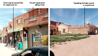
Figure 9. Changes in housing in the village of Ain Meriem (Authors, 2021)
55We also found other practices of the population, in particular to link those dissatisfied with the interior layout of the dwelling, they resorted to its demolition and reconstruction according to their tastes and needs. Despite that, in most cases, this was in violation with the regulations in force especially in the villages of Ain Messbah and Seraidi (10%). We have seen a resurgence of traditional activities related to the rural area, particularly in the villages of Biban al-Messbah and Dayat el Terfas, by allocating one-bedroom space to grain storage (4.6%) or by building some cattle shed next to the house by an illegal extension of the dwellings (5%).
56Homes in socialist villages have seen an increase in their level of equipment, particularly for electrical appliances and household appliances, such as refrigerators and televisions, which have reached more than 80% in most households in socialist villages. It should be noted, however, that air conditioners and washing machines reached a lower percentage (10.7%) only, especially in the village of Ain Bouchekif5.
57Links between villages, and large urban centers have increased as a result of the development of public transport, and the acquisition of personal cars (34.8%), which has enabled the social and economic integration of the inhabitants of these villages, especially women craftsmen (11%), who have thus been able to access a new market in large urban areas such as Tiaret, Mahdia and Sougueur. Thus allowing the household to have new cash flow that is no longer content, with the income of agricultural activities or the salaries of civil servants.
58Housing has also undergone functional transformations or is no longer used solely for housing but also for commercial and artisanal activities (12.3%), especially along major roads. This is a clear indicator of the city’s influence on rural society and also of the integration of villages into the urban network and its economic system.
59The villages have allowed a social mix from their creations to today, people from different backgrounds. Bringing together members of local tribes (Beni Maida, Beni lent, Ouled Ahmed Al-Rechaiga, Doui Hasseni, Al-Aouisset, Al-Sahari, Ouled Lakred and others (44.8%) and people from foreign tribes in Sersou (Larba, Ouled Naïls and Saïd Atba 17.9%) coming from the south, and other tribes coming from the North (Mountain the Ouarsenisses, 16.8%). The villages first, attracted farmers from the cooperatives of the agrarian revolution and pilot farms, seasonal peasants and nomads. Other people working in support positions in the tertiary sector have also been attracted to these villages. Following the integration of these villages into the Sersou urban network, they attracted a new category of workers, particularly in the agricultural and industrial sector (members of the tribes of Oued lahou, khellafa and Rouabeh, 13.4%) and others (7.1%), others came to settle there for the availability of land and its affordable price (village Ain Messbah, Ain Meriem, Ain Bouchekif).
60These villages are also a support to the housing stock of large urban areas, attracting young families from Sersou and elsewhere, wishing to emancipate themselves from the large family, seeking to rent apartments in collective dwellings at low prices compared to large urban areas. However, this allows them also to benefit from the services offered in the region (7.5%). These young families wish to secede from the large family on the one hand and benefit from the activities of the region on the other hand, which reflects the transformation of the rural community from an extended family to a poly-nuclear family.
VI. THE SERSOU OF AGRICULTURAL FUNCTION TO MULTIFUNCTIONALITY
61The number of employees in the agricultural sector was less than 50% in Sersou in 1966, reaching 63.8% of the total population occupied during the year 1977. This rate fell sharply to only 18% in 1987 and 15.9% in 1998. The socialist villages have experienced the same change in the sectors of activity as the Sersou with a drastic decline in the number of occupied in the agricultural field.
62Several factors have led to this decline in agricultural activity, including the nature of this activity in the cereal-growing region, which only employs a low seasonal employee. Add to this the drought that the region experienced during the 1970s and 1980s. The establishment of several industrial units also had a great impact on the loss of rural agricultural labor that lived in precarious conditions, which led to the change of the initial function of some villages (Ain Bouchekif, Ain Meriem, Selmana...). The tertiary sector also contributed to the decline in the agricultural labor force, following the various administrative redistricting in the region (Ain Bouchekif, Rechaiga, Sebaine, Bougara, and Nadorah).
63Incomes from agricultural activities declined significantly, as other sectors improved their incomes and needed to become more attractive. This wage system began to reach the countryside in general in various regions of Algeria, which caused the agricultural land to lose its social and symbolic value. So much so that the workers of the “agrarian revolution" had just a fixed, albeit low, monthly wage, which had nothing to do with the increase or decrease in agricultural production, which led the fathers of families to seek more profitable work.
64The field survey that we conducted showed a predominance of activity related to the tertiary sector with 65% of workers followed by the agricultural sector with 22.7% and the industrial sector with just 15% (Table 3). This phenomenon of tertiarization of economic activities is more pronounced at the Ain Messbah level (83.7%) and Ain Bouchekif (66.1%); this is due to their proximity to the city of Tiaret. Unlike the village of Dayat el Terfas, which has been able to maintain its agricultural vocation where 75% of its inhabitants are occupied in the agricultural sector, this is due to its remoteness from the main urban centers of the region. The village of Selmana has the highest rate of occupancy in the industrial and public works sector (52%)6, given the existence of a new industrial agro-food processing unit (flour mill, oil mill ...) also the presence of numerous construction projects in the region.
|
VAS |
Agriculture |
Industry and Public Works |
Trade and Service |
Total |
||||
|
Number |
% |
Number |
% |
Number |
% |
Number |
% |
|
|
Dayat Terfas |
15 |
75.0 |
0 |
0,0 |
5 |
25,0 |
20 |
100 |
|
Biban Messbah |
8 |
33,3 |
0 |
0,0 |
16 |
66,7 |
24 |
100 |
|
Sebaine |
9 |
30.0 |
2 |
6,7 |
19 |
63,3 |
30 |
100 |
|
Rechaiga |
16 |
26,7 |
8 |
13,3 |
36 |
60,0 |
60 |
100 |
|
Ouancharis El-Beida |
9 |
25.0 |
7 |
19,4 |
20 |
55,6 |
36 |
100 |
|
Mellakou |
10 |
20,4 |
3 |
6,1 |
36 |
73,5 |
49 |
100 |
|
Ain Meriem |
5 |
18,5 |
5 |
18,5 |
17 |
63,0 |
27 |
100 |
|
Ain Bouchekif |
5 |
8,5 |
15 |
25,4 |
39 |
66,1 |
59 |
100 |
|
Ain Messbah |
2 |
4,7 |
5 |
11,6 |
36 |
83,7 |
43 |
100 |
|
Total |
79 |
22,7 |
45 |
12,9 |
224 |
64,4 |
348 |
100 |
Table 3. Workers in Socialist Villages by Economic Sectors. Source: Field survey 2021
65Residence in the majority of socialist villages was not related to land ownership; a large percentage (77.5%) of families did not own farmland. While families who own land, much of it is only engaged in farming or in seasonal agriculture in terms of speculation without irrigation (8.9%), in addition to other activities, during free time or on weekends.
66This complementary agricultural activity is more the work of retirees and employees (63.5%), as well as some land owners who lease their farmland for farmers in Sersou or also from outside (26%).
67This is one of the methods used by some families to find another source of income improvement and others to acquire new skills in agriculture, especially in the cultivation of vegetables and fruit trees as in Rechaiga and Sebaine. It also proves the transformation that has taken place, because we find a new professional category in rural society, a class of peasant employees.
68The proportion of those engaged in agricultural activities does not reflect the reality of the situation because the population adopts multiple methods by which it combines several activities to diversify its income and because agricultural activity has not been taxed since the 1970s and the statistics on this remain very unclear.
69One of the major changes in the Sersou plain has been the transition from dry-to-dry agriculture (Sahli, 1991; Duvigneau, 2004; Otmane, 2005; Derderi et al., 2019) to the cultivation of vegetables, legumes, fruit trees and even cereals, in irrigated by attracting investors and farmers from different parts of the country. This development has led to a new agricultural dynamic and the development of the associated trade sector and has given Sersou a national dimension not only in cereal production, but also in other agricultural products.
70The various natural assets of the Sersou plain, its fertile soil, and its variety of resources in surface, and slick water have allowed it to become an agricultural area specialized in large agriculture, and cereal production of all kinds. In particular durum wheat and some legumes, which attracted the attention of the colonizer to this plain and settle there to make it the granary of wheat throughout the Algerian west. This allowed the development of a food industry, consisting of three factories in Tiaret and Mahdia, and four-grain warehouses in Tiaret, Mahdia, and Hamadia and Si al-Haouas.
71Agricultural activity continued in the 1970s and 1980s. At the end of the latter, a new agricultural model based on irrigation was born under the low on land grants, by the land development of 1983 which mainly affected the southern Sersou, with an area estimated at 2313.5 hectares7 and Nadorah with an area of 2313.5 ha. This has allowed the region to become a national agricultural hub in the production of certain vegetables (onions, potatoes and garlic) and fruit trees (apples). Irrigation perimeters reached an area of (2012,4 hectares) by exploiting the waters of Bougara and Dahmouni dams but also groundwater after drilling deep wells as part of the national agricultural development plan from the 2000s (3,130 were recorded in the state of Tiaret in 2020). The area of irrigated agricultural perimeters increased 36-fold from 1985 to 2020, it rose from 580 hectares in 19858 (16.5% of the area of the state of Tiaret 3,550 hectares) to 21,197.55 hectares in 2020 (60% of the area of the Tiaret region).
72Sersou is currently experiencing strong agricultural activity, linked to the influx of farmers and capital from areas characterized by agricultural knowledge and the like Mascara, Ain Al-Defla, Blida and Mila.
73One of the factors that has played a key role in attracting these new investors is water, as well as the increase in demand for agricultural products due to population growth and improved living standards, all these factors have made these agricultural products very profitable.
74These agricultural investors experience a great deal of permanent mobility in the Sersou region and depend on the availability of land and water, their investments are made on land leased for limited periods, at the level of collective or individual farms, as well as at the level of land developed after 1983. The statistics of the irrigated lands in Sersou are represented in Figure 10.
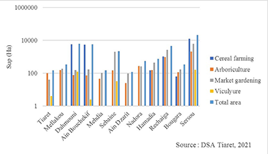
Figure 10. Irrigated farmland in Sersou (Tiaret 2021)
75Administrative promotion played a central role for the socialist villages of Sersou. Where five villages in the state of Tiaret became chief towns in 1984, allowing them to benefit from a number of new facilities, and to supervise their territories, as well as contribute to the functional restructuring of the Sersou urban network, which led to transformations in its urban and functional structure. The vocation of Sersou was affirmed during the colonial period and a food industry was established there through milling decimated on its territory. The situation followed the same trend until the mid-1970s; these units employ only 835 workers (Development plan of state of Tiaret, 1986 p.195).
76From there, a new manufacturing industry was born; it included the mining and mechanical industries, industrial industries that broke with the agricultural vocation of the region. Two industrial zones were set up, one in Tiaret and the second in Ain Bouchekif. As well as the development of a number of activity area (6000 jobs9). Tiaret thus became the second industrial hub of western Algeria after Oran, on the same level as Tlemcen and Sidi Bel Abbas.
77The establishment of these heavy industries in this agricultural area of excellence has had a negative impact on agricultural activity, where it has created competition for land, encouraged the rural exodus and attracted agricultural employment, the employment rate in the industry rose from 6.9% in 1985 to 9.8% in 1989 (Hachlef, 1988). It has also reshaped the urban network of Sersou.
78The period of the 1990s saw a significant decline in industrial activity and the closure of many businesses and the dismissal or reduction of their number of employees, the unemployment rate in the state of Tiaret rose from 23% in 1987 to 28.3% in 1998, which had a negative impact on the economic and social level of the region.
79After the financial upswing in the country following the rise in oil prices in the early 2000s, Sersou has seen a revitalization of industrial activity (Table 4), due to the existence of an important industrial base; this last has developed with the development of new zones (industrial in Tiaret, Ain Bouchekif and others of activity in Selmana and Sidi Mansour). Industrial car assembly units, destined for the domestic market in Tiaret and Khemisti in partnership with major international companies (Mercedes Germany and Hyundai Korea), and another for the military sector in Ain Bouchekif, were established. In addition, some of the lots in these industrial zones have been allocated to small and medium-sized enterprises that employ less than 50 workers (7.7% of all enterprises in the state of Tiaret).
|
Industrial zones and activity zones |
Surface (Ha) |
Number of lots |
|
IZ Zarroura (Old) |
318 |
443 |
|
IZ Zarroura (New) |
328 |
292 |
|
IZ Ain Bouchekif (New) |
319 |
334 |
|
ACZ Mahdia |
10 |
68 |
|
ACZ Sidi Mansour (Khemisti) |
12 |
66 |
|
ACZ Selmana (Laayoune) |
3.93 |
- |
|
ACZ Tissemsilt |
21.1 |
153 |
|
SNVI (ex SONACOM) Ain Bouchekif |
299 |
- |
|
ACZ Tiaret |
Hangars and businesses closed |
Recovery of land and use it to create housing |
Table 4. Sersou Current Industrial Regulations. Source: Department of Industry and Mines (DIM) of the state de Tiaret and Tissemsilt (2021)
80This new industrial dynamic was also impacted by the agricultural dynamics of Sersou, which recorded new investments in the agro-food industrial sector (36.4% of all SMEs outside the trade and services sector), notably the Milk a Tiaret and Khemisti sector (Figure 11).
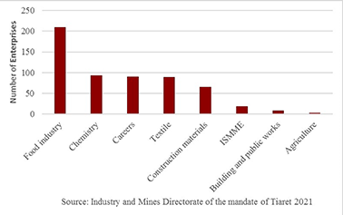
Figure 11. Distribution of Small and Medium Enterprises by Activity in state of Tiaret, 2021
81The socialist villages were also affected, by this settlement, with the opening of an oil factory in Rechaiga, and another in Selmana, which has also benefited from the establishment, of a flourmill and white and red meat production units, thanks to the aid provided to young people in rural development programs. Industrial employment in Tiaret reached 939910 workers at the end of 2020, which could explain the drop in the unemployment rate in the state of Tiaret to 9.8% in 201911.
CONCLUSION
82The policy of modernization of the Algerian rural world adopted by the state in the 1970s by establishing the agricultural villages of Sersou has produced rural settlements, which densified the urban network. They have gradually integrated and created an acceleration of population growth. This has led to their spatial extension breaking with the model of their original design.
83In the early 1980s, socialist villages experienced a process of urbanization driven by the establishment of an industrial fabric in the region. The administrative promotion of some villages in the capital of the municipality has also led to the competition of the former urban centers in their areas of influence.
84The presence of these villages in a region with important economic components, has integrated administrative and economic support centers into their general development dynamics, within an interactive and complementary relationship with the various other agglomerations.
85The socialist villages of Sersou helped stabilize the population that settled there. However, the latter changed the layout of these villages according to their needs and inclinations. This led to a profound change in the urban components of the villages, which imposed new practices on them and thus integrated them into the urban network of the region.
86The socialist villages have undergone spatial, economic and social changes. Some have become semi-urban settlements, or areas of urban extension of the surplus population of the municipalities Tiaret and Tissemsilt.
87The spatial growth was supported by the allocation of new function thanks in particular to the availability of public land. These settlements will keep only the name and date of creation of socialist village.
88Agriculture has ceased to be the main function in many agricultural villages due to spatial extensions resulting from the important state intervention in housing developments. Many jobs were created in the tertiary sector, especially in trade and services.
89Agriculture has become secondary or complementary for many inhabitants of socialist villages, despite its evolution from dry to irrigated agriculture, playing a central role in the production of certain agricultural products in addition to cereal farming at regional and national level.
NOTES
901The National Bureau of Statistics defines settlements (agglomeration) as concentrating more than or equal to 100 housing units, and the distance between them does not exceed 200 meters.
912At the national level, the state allocated 450000 housing units to rural areas in the first Five-Year Plan (2005-2009) (2010-2014) (Bekkouche, 2016).
923Article 5 of Executive Decree No. 06-486 of December 23, 2006 defines the modalities for managing the Special Allocation Account No. 116-302 entitled “The Special Fund for the Economic Development of the Highlands,” Official Gazette No. 84).
934Urban social housing fragmentation program directed to the states of the south and the higher plateaus according to Joint Ministerial Instruction No. 01.
945General Census of Housing and Population 2008 (National Bureau of Statistics).
956The director plan for development and urban planning of the municipality of Laayoune (2016) p 65.
967Otmane, 2005 P 176.
978Development plan of state of Tiaret (1986) p.113-116.
989ANDI (State of Tiaret).
9910Directorate of Industry and Mines for the State of Tiaret 2021.
10011Directorate of Programming and Budget Management of Tiaret 2020.
REFERENCES
101Arecchi, A., Megdiche, C. (1979), Les villages socialistes en Algérie. Cahiers de la Méditerranée, 19, 3-14. Consulted at https://www.persee.fr/doc/camed_0395-9317_1979_num_19_1_1457
102Bekkouche, A. (2016). Habitat Rural En Algérie Impact Des Mutations Sociales Sur La Production Du Logement Cas De La Vallée De La Seybouse Wilaya De Guelma. Thèse de doctorat en architecture université d’Annaba, 398p.
103Bessaoud, O. (1980). La révolution agraire en Algérie : continuité et rupture dans le processus de transformations agraires. Tiers-Monde, 21(83), 605-626. Consulted at https://doi.org/10.3406/tiers.1980.
104Chabi, N. (2008). Les Villages Socialistes, une image fabriquée pour l’espace rural. Sciences & Technologie D, 27, 53-60. Consulted at https://fr.scribd.com/document/488602475/LES-VILLAGES-SOCIALISTES-UNE-IMAGE-FABRIQUEE-POUR-1-pdf
105Christiansen, P.O. (2020). Peasant and Farming Villages. Consulted at (https://www.encyclopedia.com/international/encyclopedias-almanacs-transcripts-and-maps/peasant-and-farming-villages). On January, 2022
106Cocaud, M. (2005). Améliorer l’habitat rural, in La maison rurale en pays d’habitat disperse. Presses universitaires de Rennes, Rennes, pp 51-61. Consulted at https://books.openedition.org/pur/11690#authors
107Côte, M. (1986). L’habitat rural en Algérie, formes et mutations. Annuaire de l’Afrique du Nord, Tome XXV Editions du CNRS, pp. 299-316.
108Côte, M. (1994). L’urbanisation en Algérie : idées reçues et réalités. Travaux de l’Institut Géographique de Reims (n°85-86) Etudes Algériennes. pp. 59
109Côte, M. (2011). L’Algérie, mondialisation et nouvelles territorialités. Méditerranée, 116, 77-84.
110De Villers, G. (1980). L’État et la révolution agraire en Algérie. Revue française de science politique, 30ᵉ année (n°1), pp 112-139. Consulted at https://doi.org/10.3406/rfsp.1980.393880
111Derderi A, Daoudi A, Colin JP. (2019). Les entrepreneurs agricoles itinérants et leur rôle dans les dynamiques foncières et agraires dans les zones arides en Algérie, Le cas de Rechaïga. Collection Recherche. Paris, Comité Technique Foncier et Développement (AFD-MEAE).
112Doret, C. Megdiche, C. (1979). Perception et connaissance des villages socialistes auprès des futurs architectes algériens. Cahiers de la Méditerranée, 19. Villages socialistes en Algérie / Le Dahir berbère de 1930 et le monde arabe. pp. 35-38.
113Duvigneau, G. (1986). Nouveaux modes d’occupation de l’espace, nouveaux modes d’habiter sur les hauts plateaux Algériens. Edition du CNRS, Annuaire de l’Afrique du Nord, Tome xxv p 323.
114Duvigneau G. (2004). Mythe et réalité de l’aménagement en zone steppique : la mise en valeur en irrigué à Rechaïga, wilaya de Tiaret, In : Bendjelid A., Brulé JC, Fontaine J. Aménageurs et aménagés en Algérie. Paris : L’Harmattan, p.133-135.
115Fekar, O. (2013). French urban settlement in the countryside of Algeria, a socio-historical approach. Journal of the University of Damascus, 29(3-4), 590.
116Hachlef, M. (1988). L’industrialisation de l’Algérie intérieure Tiaret et sa région. Thèse de doctorat en géographie, université François Rabelais, 350 P.
117Houchine, K. (2007). The problem of agricultural real estate and achieving food security in Algeria. Ph.D. thesis in economic sciences, University of Algiers, 352 p. https://www.persee.fr/doc/camed_0395-9317_1979_num_19_1_1458
118Ibrahim, S. Gaber, M. (2010). Rural Development Policies in Egypt. SUSTAINMED Working paper (n° 02) V2 (2) 10/102010, pp1-16. Consulted at https://www.researchgate.net/profile/Ibrahim-Soliman-7/publication/321866618_Rural_development_policies_in_Egypt/links/5a48964d458515f6b0572d0e/Rural-development-policies-in-Egypt.pdf?origin=publication_detail
119Kasdallah, N. (2013). Dynamiques d’urbanisation des villes intermédiaires au Maghreb (Algérie, Maroc et Tunisie) : Effet chef-lieu et perspectives de développement. Thèse de doctorat en géographie. Université De Cergy-Pontoise 351 p.
120Le Coz, J. (1979). Dynamique de la Révolution agraire algérienne. La phase de la «bataille de la gestion». Méditerranée, troisième série, 35(1-2). L’homme et son milieu naturel au Maghreb. pp 93-97 Consulted at https://doi.org/10.3406/medit.1979.1902.
121Lesbet, D. (1983). Les 1000 villages socialistes en Algérie. Office des Publication universitaire France, 335p.
122Megdiche, C. (1979). Le financement des villages socialistes. Cahiers de la Méditerranée.
123Villages Socialistes en Algérie / Le Dahir berbère de 1930 et le monde arabe (n°19), pp 15-33.
124Otmane, T. (2005). Mise en valeur agricole et mutations socio-spatiales en milieu steppique : le cas de la wilaya de Tiaret. Insaniyat, 29-30, 175-189.
125Perrin, R. (1960). Le Sersou, Etude de géographie humaine (Premier article) https://www.persee.fr/doc/medit_0025-8296_1960_num_1_2_987
126Perrin, R. (1960). Le Sersou, Etude de géographie humaine (Deuxième article) https://www.persee.fr/doc/medit_0025-8296_1961_num_2_1_3418
127Saada, M. & Hmouda, A. (2020). Habitat Rural : Vers Un Nouveau Fonctionnement De La Ruralité Cas De La Commune De Tigharghar (Aures –Algérie). Revue Roumaine de Géographie, Bucureşti, 64(2), 215-227.
128Safar- Zitoun, M. (1976). Les villages socialistes de la Révolution agraire en Algérie : l’adaptation sociale à un cadre écologique nouveau. Thèse de 3e cycle de sociologie, Montpellier, 383 p. https://om.ciheam.org/article.php?IDPDF=CI911704
129Sahli, Z. (1991). Ecosystèmes en crise, risques et sécurité dans une agriculture méditerranéenne ; Le cas de la zone semi-aride du Sersou (Tiaret, Algérie). Montpellier : CIHEAM Options Méditerranéennes : Série A. Séminaires Méditerranéens (n° 21), pp 49-52.
130Salman, M. (2017). Modern trends for sustainable architecture an analytical study of housing design principles. Published by Dar Amjad for Publishing and Distribution. 320p.
131Authors coordinates:
132Aicha MEZIANI
133PhD student in Geography and Spatial Planning
134Laboratory of Geographic Space and Territorial Planning (LAGTA)
135University Oran 2, Mohamed Benahmed, ALGERIA
136aicha_meziani@hotmail.fr
137Tayeb OTMANE
138Professor of Geography and Spatial Planning
139Laboratory of Geographic Space and Territorial Planning (LAGTA)
140University Oran 2, Mohamed Benahmed, ALGERIA
141otmanet1@yahoo.fr
Para citar este artículo
Acerca de: Aicha MEZIANI
PhD student in Geography and Spatial Planning
Laboratory of Geographic Space and Territorial Planning (LAGTA)
University Oran 2, Mohamed Benahmed, ALGERIA
aicha_meziani@hotmail.fr
Acerca de: Tayeb OTMANE
Professor of Geography and Spatial Planning
Laboratory of Geographic Space and Territorial Planning (LAGTA)
University Oran 2, Mohamed Benahmed, ALGERIA
otmanet1@yahoo.fr
