


- Startpagina tijdschrift
- volume 9 (2005)
- numéro 2
- Methodology for the elaboration of Natura 2000 sites designation acts in the Walloon Region (Belgium): calcareous grasslands in the Lesse-and-Lomme area


Weergave(s): 1697 (10 ULiège)
Download(s): 109 (2 ULiège)

Methodology for the elaboration of Natura 2000 sites designation acts in the Walloon Region (Belgium): calcareous grasslands in the Lesse-and-Lomme area

Résumé
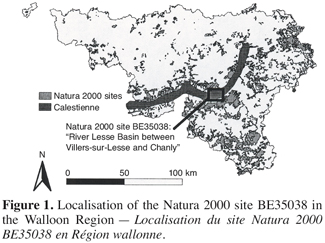
Méthodologie d’élaboration des arrêtés de désignation des sites NATURA 2000 en Région wallonne (Belgique) : les pelouses calcaires de la région de Lesse-et-Lomme. En Région Wallonne (Belgique), 239 sites ont été sélectionnés pour faire partie du réseau Natura 2000. La prochaine étape est la rédaction des arrêtés de désignation visant à protéger légalement ces 221.000 ha. Dans une étude pilote, un projet d’arrêté de désignation a été élaboré pour un site Natura 2000 de 2.569 ha situé dans la région de Lesse-et-Lomme en Calestienne. Bien que le site comprenne 40 ha de pelouses calcicoles, caractérisées par une flore et une faune exceptionnelles, cet habitat est très menacé par l’abandon et la fragmentation. La méthodologie utilisée pour réaliser l’arrêté de désignation est présentée. Dans un premier temps, au printemps et en été 2003, une cartographie détaillée des habitats naturels a été réalisée, au cours de laquelle chaque parcelle de pelouse calcaire a été identifiée et inventoriée. Sur base des informations récoltées, les états de conservation ont été évalués en fonction de trois critères : (1) l’intégrité du cortège d’espèces, (2) la structure de l’habitat et (3) les dégradations. Troisièmement, le site a été divisé en zones d’objectif en fonction des différents habitats et espèces d’intérêt communautaire présents. Ainsi, une zone d’objectif a été délimitée pour les pelouses calcaires. Cette zone d’objectif a ensuite été divisée en plusieurs unités de gestion. Finalement, à ces différentes échelles (site, zone d’objectif, unité de gestion), des mesures de gestion ont été proposées. En conclusion, dans l’avant-projet d’arrêté de désignation, l’objectif est de maintenir ou de restaurer 230 ha de pelouses calcaires, à partir des 40 ha existants. Cet objectif ambitieux requiert des opérations de restauration à grande échelle et un schéma de pâturage efficace. Afin d’être menées avec succès, ces opérations réclament des ressources importantes.
Abstract
In the Walloon Region (Belgium), 239 sites have been selected to be included in the Natura 2000 network. The next step is to write designation acts in order to legally protect these 221,000 ha. In this pilot study, a designation act was elaborated for a Natura 2000 site of 2,569 ha and located in the Lesse-and-Lomme area within the Calestienne region. Although the site includes 40 ha of calcareous grasslands, characterised by an exceptional flora and fauna, this habitat is very threatened by abandonment and fragmentation.The methodology used to elaborate the designation act is presented with respect to calcareous grassland. Firstly, in spring and summer 2003, an accurate map of natural habitats was produced, with every single patch of calcareous grassland being mapped. Information was also collected in order to evaluate conservation status. Based on this information, conservation status was then assessed with respect to three different criteria: (1) integrity of the cortege species, (2) habitat structure and (3) degradations. Thirdly, the site was divided into objective zones according to the different habitats and species of Community interest found in the site. Hence, an objective zone was delineated for calcareous grasslands. This objective zone was then divided in several management units. Finally, at these different spatial levels (site, objective zone, management unit), management measures were suggested. As a result, in the draft designation act, the target is to maintain or restore 230 ha of calcareous grassland, instead of the existing 40 ha. This ambitious target requires large-scale restoration and an efficient grazing scheme. These will need important resources for their successful implementation.
Inhoudstafel
1. Introduction
1Following the European Directives 79/409/CEE (Birds Directive) and 92/43/CEE (Habitats Directive) and the Walloon Decree on the conservation of Natura 2000 sites, the Walloon Region has selected 239 sites to be part of its Natura 2000 network. These sites cover an area of approximately 221,000 ha, which account for 13 % of the Walloon region. A wide variety of habitats and species of Community interest (as designated in the Birds and Habitats Directive) are to be found in the Walloon Natura 2000 sites: 44 habitats – from large areas of Asperulo-Fagetum and Luzulo-Fagetum beech forests to small remnants of species-rich Nardus grasslands – 31 non-bird species and 52 bird species.
2In order to legally protect these sites, it is now urgent to provide each of them with a designation act. Once they are voted into law by the Walloon Parliament, designation acts will constitute the legal basis on which Natura 2000 sites will be protected and managed. For instance, management agreements that will be signed between the Walloon Region and private landowners will be grounded on the content of designation acts. Hence, a designation act has to include, among other things:
3– an accurate map of habitats of Community interest for which the site has been selected;
4– an evaluation of the populations of species of Community interest for which the site has been selected;
5– the management objectives for the site;
6– the measures to be applied in and out of the site to prevent significant deterioration of habitats and perturbation of species.
7Thus, the elaboration of a designation act implies some important scientific work, including data collection and analysis. All these stages necessitate the development of methodologies that can be used for all Natura 2000 sites. In this context, the Walloon Region has signed a convention with four university laboratories to develop and test these methodologies on a few selected Natura 2000 sites. The Laboratory of Ecology (Gembloux Agricultural University) worked on the site BE35038: “River Lesse Basin between Villers-sur-Lesse and Chanly”. The methodology adopted is a result of discussion and conciliation with the Research Centre on Nature, Forest and Wood (DGRNE-DNF).
2. Natura 2000 site BE35038: “River Lesse Basin between Villers-sur-Lesse and Chanly”
8The Natura 2000 site “River Lesse Basin between Villers-sur-Lesse and Chanly” is located in the Calestienne region. Calestienne is the name given to a continuous and often narrow limestone band that runs from the region of Liège to Chimay in southern Belgium (Figure 1). The site has a total area of 2,569 ha and is articulated around the mid River Lesse valley. This area is commonly called the “Lesse-and-Lomme” area after the names of the two main rivers that cross the area. On both sides of the River Lesse and its tributaries, the larger part of the site (42%) is covered by deciduous forests: for example, limestone beech forests on calcareous “tiennes” or Tilio-Acerion forests of slopes and ravines. The site also encompasses large areas of exotic coniferous and mixed forests (27% of the site area), with Pinus nigra Arnold subsp. nigra (Austrian Pine) and Pinus sylvestris L. (Scots Pine) being the most abundantly planted species. Twenty-six percents of the site are also devoted to agriculture, mainly pastures and meadows. The remaining 5% of the site are mainly occupied by rivers and calcareous grasslands. Within these land use categories, the site shelters not less than 18 habitats and 22 species of Community interest.
9The area occupied by calcareous grasslands within the site is small compared to the area occupied by other habitats of Community interest, such as beech forests or lowland hay meadows. Nevertheless, the nutrient-poor dry grasslands found in the Lesse-and-Lomme area constitute a prestigious ensemble of calcareous grasslands which shelter an exceptional flora and fauna (e.g. Thill, 1964; Duvigneaud, 1989; Godefroid, Verhelpen, 1997). This site is of primary importance for the conservation of the natural habitat in the Walloon region. Moreover, historically, the site has included much larger areas of calcareous grasslands (Thill, 1964; Dugnoille, 2003) and there might be potential areas to consider for restoration. Finally, semi-natural dry grasslands on calcareous substrates are a priority habitat according to the Habitats Directive. As a consequence, calcareous grassland deserves particular attention.
10Furthermore, many threats can be identified, that are jeopardising the future of the Lesse-and-Lomme calcareous grasslands. These threats are similar to those encountered anywhere else in Europe:
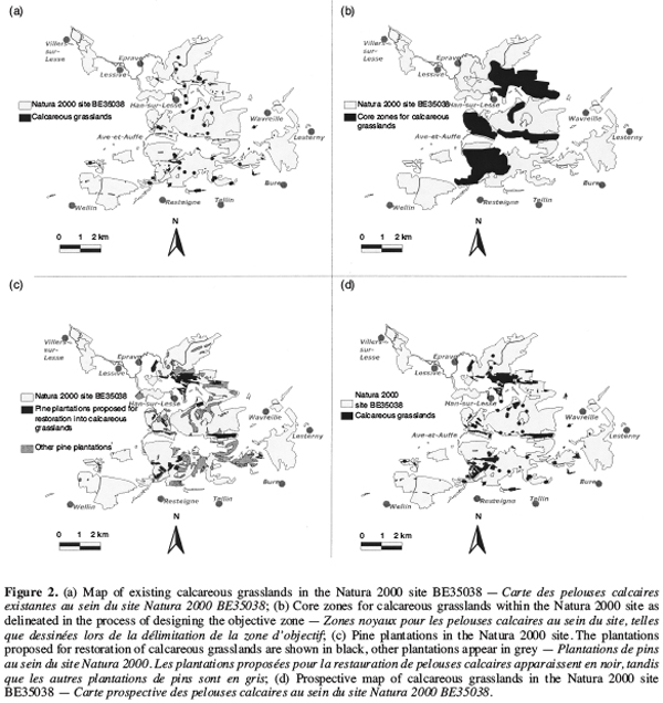
11– natural succession following abandonment and characterised by dominance of competitive species such as Brachypodium pinnatum (L.) Beauv. (tor grass) and shrub colonisation, reducing the high species richness and diversity of these grasslands;
12– afforestation, mainly through pine plantations that were realised at the end of the 19th century and at the beginning of the 20th century;
13– intensive land use practices which include ploughing and fertilisation;
14– visitor impacts on a few very sensitive sites, with tourism being developed in the area; etc.
15As a consequence, the Lesse-and-Lomme calcareous grasslands form isolated fragments in a matrix of afforested and agricultural land. Consequently, the restricted size of the sites and fragmentation are problems that need to be accounted for in the elaboration of the designation act.
3. Calcareous grasslands in the designation act
16One Natura 2000 site usually includes many habitats and many species of Community interest. When elaborating a designation act, all of these species and all of these habitats need to be considered. Although this paper focuses on calcareous grasslands, it must be kept in mind that other species and habitats are present in the same site. The process of elaboration of the designation act can be divided into four stages:
171. mapping and inventory;
182. assessment of conservation status;
193. spatialisation of management objectives; and
204. design of management measures.
21With respect to calcareous grasslands, these stages are developed here below.
3.1. Mapping and inventory
22During spring and summer 2003, an important field work was undertaken in order to produce an accurate map of natural habitats. Simultaneously, information was collected that would be used to assess the conservation status of all habitats of Community interest. Since this work was part of a pilot study, the aim was also to develop the methodology that would be implemented to map and collect field data for all Natura 2000 sites in the Walloon Region.
23The tools used on the field for cartography were recent ortho-rectified vertical aerial photos (PPNC), 1/10000 topographic maps and GPS. Natural habitats were mapped according to the Walloon version of the EUNIS typology (WALEUNIS). Habitats were mapped with great precision, especially habitats of Community interest. For instance, any patch of calcareous grassland larger than 25 m2 was individually mapped. Such a precision produced a very detailed map of natural habitats.
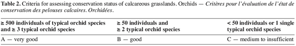
24Figure 2a is a map of the site showing calcareous grasslands, as well as other habitats of Community interest that are frequently associated with calcareous grasslands and that were simultaneously considered in the elaboration of the designation act. These “associated habitats” are mesotrophic Calluna vulgaris (L.) Hull (heather) heaths, Juniperus communis L. (juniper) scrubs on calcareous grasslands, rupicolous calcareous grassland of Alysso-Sedion albi, petrifying springs with tufa formation, calcareous screes and open thermophilic communities (Alysso-Sedion albi) on rock basophilous substrates. All these habitats, together with calcareous grasslands, are gathered under the generic name “calcar open habitats”. Their total area within the site is approximately 40 ha. The very fragmented situation in which these habitats are today clearly appears on figure 2a.
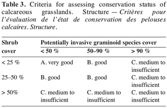
25In parallel with the mapping process, information was collected on the field in order to assess conservation status. For calcareous grasslands, collected data include:
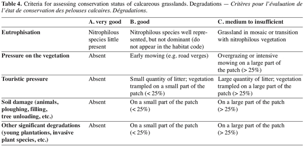
26– an exhaustive inventory of superior plants species in each patch of calcareous grassland, with an evaluation of the population size for each species;
27– information about grassland structure, i.e. whether the structure is open with bare ground and bryophytes, or closed with one or several strata of graminoid species;
28– percentage covers for shrubs and potentially dominant and invasive graminoid species like B. pinnatum, Bromus erectus Huds. (upright brome) and Sesleria caerulea (L.) Ard. (blue moor-grass);
29– significant degradations, such as pressure on the vegetation, damage to the soil surface, etc.
3.2. Assessment of conservation status
30The Habitats Directive stipulates that Member States need to maintain and restore, at favourable conservation status, habitats and species of Community interest. Even though what is a “favourable conservation status” remains unclearly defined, it is a key concept under Natura 2000 legislation (WWF, 2001).
31In the elaboration of designation acts, two roles can be distinguished for the assessment of conservation status. Firstly, the European Commission asks for an evaluation of the conservation status of each habitat and species of Community interest within each Natura 2000 site. For example, within the Lesse-and-Lomme site, the designation act should indicate total areas of calcareous grassland for the three conservation status levels: very good conservation status (A), good conservation status (B) and medium to insufficient conservation status (C). This evaluation is global and does not necessarily imply accurate assessment of each patch of habitat within Natura 2000 sites.
32Secondly, the assessment of conservation status might be a useful decision-making tool when spatialising management objectives and defining management priorities. For instance, maintaining patches in the best conservation status could be considered as a priority. Thus, conservation status could be seen as a way to objectify decision-making when elaborating a Natura 2000 site designation act.
33The criteria chosen to assess conservation status of habitats of Community interest are those established in the German Land Nordrhein Westfalen (Verbücheln et al., 2002). Three criteria were used by these authors:
34– integrity of the species cortege;
35– habitat structure; and
36– degradations.
37The implementation of these criteria to Lesse-and-Lomme calcareous grasslands is presented here below.
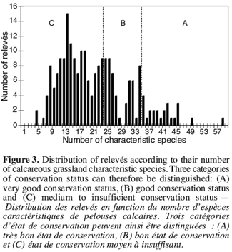
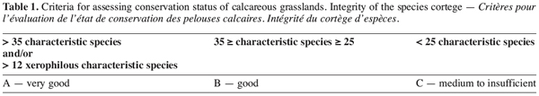
38Integrity of the species cortege. The first step was to determine which plant species make the typical cortege of calcareous grasslands in the Walloon Region. Based on the literature (e.g. Noirfalise, Dethioux, 1984; Royer, 1991), a list of characteristic species was established. Then, for each patch of calcareous grassland, the number of characteristic species could be calculated. The distribution of the patches according to their number of characteristic species is presented in figure 3. Very few patches have high numbers of characteristic species, while a large number of patches have relatively low number of typical calcareous grassland species. In order to divide patches into the three conservation status classes according to the species cortege criteria, thresholds were needed. These thresholds (vertical dotted lines on figure 3) were mainly defined on the basis of expert judgement. A patch was assessed as being in a very good conservation status for the species criteria if it had more than 35 characteristic species. However, for xerophilous grasslands, the number of characteristic species is often low, although the typical species have a very high patrimonial value. Subsequently, a patch was also considered in a very good status if it had more than 12 characteristic xerophilous grassland species. Table 1 presents the thresholds used for this criteria.
39In addition, calcareous grasslands which are also important orchid sites are a priority habitat, according to the Habitats Directive. These sites should therefore be given the greatest level of protection. Thus an evaluation of orchid populations in calcareous grassland patches is proposed on the basis of the number of typical orchid species and the number of individuals observed. This criteria is presented in table 2. However, since this assessment is grounded on data from one single year and since orchid populations fluctuate from one year to another, the results must be interpreted with care.
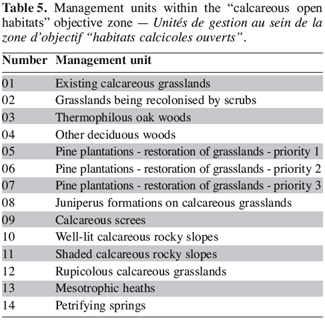
40Habitat structure. The evaluation of calcareous grasslands according to the structure criteria is grounded on the following field data: general structure of the grassland, shrub cover and graminoid species cover. A proposal of assessment is presented in table 3. Yet, this proposal has not yet been validated and further work is needed in order to establish links between habitat structure and vegetation, as well as between structure and other taxonomic groups. Indeed, different species groups might have different requirements in terms of habitat structure. For instance, the Scotch argus [Erebia aethiops (Esper, 1777)] is a butterfly species whose distribution in Wallonia is restricted to the only Lesse-and-Lomme area. In this area, this endangered species lives in calcareous grasslands that are partly colonised by juniper or other shrub species (Goffart et al., 1999). The assessment of habitat structure can therefore be very different following which species or group of species is targeted.
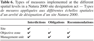
41Degradations. Table 4 presents an evaluation proposal for the degradations criteria, on the basis of the degradations recorded during field work. In this assessment, the worse degradation determines the final score for the criteria.
42The three criteria (integrity of the species structure, habitat structure and degradations) can then be aggregated following simple rules. Hence, in the end, each patch of grassland can be characterised by its conservation status. For the Lesse-and-Lomme site, 6.88 ha of calcareous grasslands are in a very good conservation status, while 19.43 ha are in a good status and 7.80 ha are in medium to insufficient status.
43A favourable conservation status of a natural habitat means that populations of species typical of this habitat are viable in the long term. Therefore, with an habitat as fragmented as calcareous grasslands in the Lesse-and-Lomme area, spatial features such as patch area, shape and connectivity should be included in conservation status assessment. However, these features are currently not part of the assessment and thus, conservation status as such is only a descriptive evaluation of a patch, without accounting for its size and position within the landscape. Yet, these spatial features are important when defining management and/or restoration measures. Hence, they need to be considered in the next stages of the elaboration of the designation act, i.e. the spatialisation of management objectives and the design of management measures.
3.3. Spatialisation of management objectives
44The territory of a Natura 2000 site must be divided into distinct “objective zones” corresponding to different management objectives. These objectives usually refer to different habitats or species of Community interest. For instance, within a site, there might be an objective zone for beech forests, an objective zone for red-backed shrike (Lanius collurio) and an objective zone for otter (Lutra lutra). One single objective zone might also refer to several habitats and/or species, if these habitats/species beneficiate from same management objectives on the same parts of the Natura 2000 site. For example, an objective zone can target one habitat, such as oak-hornbeam forests of the Carpinion-betuli, and one species that uses oak forests as its habitat, such as middle spotted woodpecker (Dendrocopos medius).
45Each of these objective zones is divided in smaller units, called “management units”, where the same management measures are to be implemented.
46The Lesse-and-Lomme site was divided into 14 objective zones. Among these, one objective zone was delimited for calcareous open habitats – including calcareous grassland and associated habitats. The manner in which this objective zone was designed and divided into management units is examined here below.
47Design of the objective zone. In order to design the objective zone for calcareous open habitats, a step-by-step approach, starting from the map of natural habitats and conservation status assessment, was used.
48Firstly, core zones were delineated (Figure 2b), that include most existing ensemble of calcareous grassland patches in a very good and good conservation status together with sites where restoration could be a priority objective. Inside these large core areas and using the detailed map of natural habitats, an optimal objective zone could be drawn, including existing calcareous open habitats, restorable sites and habitats that are part of the development zone of calcareous open habitats, such as thermophilous oak woods. Sites considered as restorable were mostly presumably ancient grasslands that had been planted with pine trees or that had evolved to shrubs or young oak woods. Were excluded from the optimal objective zone other habitats of Community interest, such as Tilio-Acerion ravine forests, and intensively-used agricultural land. This step leads to a more accurate contour of the objective zone. In the next stage, this contour is tested against historical vegetation maps from 1964. The areas proposed for calcareous grassland restoration are validated so that they correspond to ancient calcareous grasslands. This is important, since the possible presence of remnants of former vegetation is likely to increase likelihood of restoration success (Willems, 2001).
49After these stages, the result is the principal objective zone for calcareous open habitats, where most restoration work need to be undertaken. However, many patches of calcareous open habitats within the Lesse-and-Lomme site are not included in this zone. Do these peripheral patches need to be part of the objective zone? Some of these patches represent relatively large areas and can thus be considered to harbour important source populations for calcareous open habitats. Other patches shelter species that are not or little represented in the principal objective zone. For instance, some dry grasslands are located on calcareous schists, where more acidophilous species mix with typical calcicolous species. Other patches are important sites for species of high patrimonial value, like orchids or gentians. Finally, a patch of habitat has a role to play at the landscape scale, for example as “rescue sites”, which may contribute to a successful restoration approach (Cousins, Eriksson, 2001). As a result, all existing calcareous open habitat patches were included in the objective zone, even though these habitats should primarily be maintained and restored in the core areas as identified in the first steps of the delineation.
50Conflicts between different management objectives. Since there are many habitats and species of Community interest within the Lesse-and-Lomme site, conflicts between different management objectives could not be avoided. The main conflict is linked to the future of pine plantations. These plantations can be restored into two habitats of Community interest, i.e. calcareous grassland or limestone beech forests. On the one hand, pine trees (mainly Austrian Pine) were planted from 1880 on calcareous grasslands, following abandonment of sheep herding. Today, these plantations have almost no economic value and the re-plantation of pine trees is not envisaged. Moreover, in order to ensure viable populations of the calcareous grassland animal and plant species, restoration of some of these pine plantations is clearly needed. These plantations, located on ancient calcareous grasslands, could therefore potentially be restored into grasslands. On the other hand, under some of these plantations, beech natural regeneration can be observed and their restoration into beech woodlands could therefore be considered (Gilissen et al., 1998).
51Furthermore, one bird species of Community interest, the Black Woodpecker (Dryocopus martius), forages in these pine woods, where its main food source, i.e. ants, is more abundant than in other types of habitats. The Lesse-and-Lomme site accommodates very high densities of Black Woodpecker and its foraging grounds need protection and management in order to conserve the species (Colmant, 1998).
52Accordingly, pine plantations were divided into three groups (Figure 2c):
53– Plantations (139 ha) located near existing beech forests and/or with beech regeneration underneath were included in the “beech forests objective zone”, in order to recreate woodland plots of sufficient size to maintain or restore the integrity of these habitats.
54– Plantations (157 ha) located in the principal objective zone for calcareous open habitats were proposed for restoration into calcareous grasslands.
55– The remaining plantations (227 ha) are included in the “Black Woodpecker objective zone”, with recommendations in favour of dead wood.
56Division into management units. Once the objective zone was delineated, the next stage was to divide it into ‘management units’. The management units are presented in table 5.
3.4. Design of management measures
57In a designation act, management measures can be implemented at three distinct spatial levels: site, objective zones and management units (Table 6). However, a designation act does not give practical and technical details of management. General objectives are formulated and global preventive measures are defined. For instance, at the site level, interdictions are, for example, to spill chemicals, to create new roads or to modify land form and nature. At the objective zone level, interdictions are, for example, to create new tree plantations, to mow road verges before the beginning of August or to spread fertilisers and chemicals. It is also recommended to manage tourist pressure and to limit antibiotic use when treating sheep or cattle. At the management units level, particular measures are proposed, such as management by extensive grazing of existing grasslands, shrub control on existing grasslands as well as on grasslands being recolonised by scrubs, clear-cutting of pine plantations to restore grassland. In accordance with the content of designation acts, practical modalities of management will then be specified in the management agreements that will be signed with private landowners and in the revision of public estate management plans.
58As an illustration, pine plantations included in the calcareous open habitats objective zone have been divided into three management units. Some plantations are located near existing core areas of calcareous grassland and their understorey vegetation still includes a subset of the typical calcareous grassland species cortege. Those plantations present the best potential for restoration and therefore are the most urgent to restore. They represent roughly 40 ha and it is suggested that they should be restored by clear-cutting within six years (priority 1). “Priority 2” plantations are approximately 50 ha of pinewoods that had been delineated as part of the ‘natural zone’ in the “plan de secteur”, which is the official sector map which details land use and land management policy in the Walloon Region. Walloon legislation specifies that:
59“The natural zone is dedicated to maintaining, protecting and regenerating natural habitats of high biological value or sheltering species which conservation is necessary (...). In this zone works are only permitted if they are necessary to active protection of these habitats and species” D.R.W. of 27 November 1997, art.38 (MB, 1998).
60These plantations could therefore be restored within 12 years, through progressive clearings and understorey grazing by sheep until complete reopening. Finally, the remaining 65 ha of pine plantations should be similarly restored within 18 years. The timing suggested for restoration is relatively short, because the longer the delay before restoration, the slower and the more difficult the restoration (Bisteau, Mahy, 2004).
4. Conclusion
61The Habitats Directive indicates the objectives of the Natura 2000 network:
62“(...) This network, composed of sites hosting the natural habitat types listed in Annex I and habitats of the species listed in Annex II, shall enable the natural habitat types and the species’ habitats concerned to be maintained or, where appropriate, restored at a favourable conservation status in their natural range” Council Directive 92/43/EEC, Art.3, §1 (EEC, 1992).
63In order to reach these objectives, the draft designation act for the Lesse-and-Lomme site envisages to maintain or restore 230 ha of calcareous open habitats. Only 40 ha of these habitats currently exist and restoration of large areas is therefore planned. Such a scheme is absolutely necessary in order to maintain the animal and plant species populations depending on these habitats.
64However, to reach this target, important resources are needed to implement the required measures, such as a grazing scheme or ambitious restoration work. The work is already in progress with LIFE-Nature projects, such as those currently working in the Lesse-and-Lomme area or the Meuse and Viroin valleys (André, Vandendorpel, 2004; Graux, 2004). It will need to continue at the end of these projects.
65Finally, the work exposed in this paper produced a draft designation act for the Natura 2000 site BE35038. This draft has now been handed in to the public administration, who is in charge of the implementation of the Natura 2000 network in the Walloon Region and, notably, of the signature of management agreements with private landowners.
66Acknowledgements
67This work was undertaken as part of the project “Development and test of a methodology for the elaboration of Natura 2000 sites designation acts”, funded by the Walloon Region (DGRNE-DNF). We are grateful to the people at the Research Centre on Nature, Forest and Wood (DGRNE-DNF) and more particularly to Louis-Marie Delescaille, whose knowledge of calcareous grasslands provided advice beneficial to this work. Vegetation relevés were partly undertaken by Emmanuelle Bisteau as part of her research. Thanks are also due to Guy-Alain Ambé for his help with databases and GIS. We also thank Marc Paquay and Pierre Limbourg for their precious knowledge of the field. Finally, the authors would like to thank Benoît André and Alexandre Vandendorpel, from the LIFE-Nature project “Restoring and managing calcareous habitat types in the region of Lesse-and-Lomme”, as well as the staff from the Nature and Forests administration in Rochefort and Wellin, and more particularly Ir. Stéphan Joris and Ir. Jean Gilissen, for their welcoming support and their useful comments throughout the work.
Bibliographie
André B., Vandendorpel A. (2004). Le projet LIFE Nature de restauration et de gestion des milieux calcaires en Lesse et Lomme – Projet LIFE2000NATURE/B/7168 – Une tradition pastorale séculaire en dernier recours. Parcs Réserves 59 (1-2), p. 22–37.
Bisteau E., Mahy G. (2004). Les banques de graines et leur contribution à la restauration des habitats : cas d’étude appliqué aux pelouses calcaires de Lesse et Lomme. Parcs Réserves 59 (1-2), p. 57–66.
Colmant L. (1998). Les sites de nidification du Pic noir (Dryocopus martius) en Wallonie, caractérisation et dynamique de renouvellement. Parcs Réserves 53 (1-2), p. 27–29.
Cousins SAO., Eriksson O. (2001). Plant species occurrences in a rural hemiboreal landscape: effects of remnant habitats, site history, topography and soil. Ecography 24, p. 461–469.
Dugnoille X. (2003). Etude du maillage écologique en relation à la gestion des pelouses calcaires du parc de la Lesse et la Lomme. Travail de fin d’études. Bruxelles : Université libre de Bruxelles, 52 p. + appendix.
Duvigneaud J. (1989). La Petite Tinaimont à Han-sur-Lesse (province de Namur). Parcs Nationaux 44 (4), p. 113–121.
EEC (1992). Council Directive 92/43/EEC of 21 May 1992 on the conservation of natural habitats and of wild fauna and flora. Off. J. Eur. Communities, L206 (22/07/92), p. 7.
Gilissen J., Baar F., Lavis E. (1998). Commune de Tellin – Aménagement de la série de Tellin/Resteigne. Ministère de la Région Wallonne, DGRNE, DNF, 56 p. + appendix.
Godefroid S., Verhelpen B. (1997). L’intérêt botanique du site de La Rouge-Croix à Han-sur-Lesse (province de Namur, Belgique). Nat. Belg. 78 (1), p. 17–24.
Goffart P., McCarthy T., Renaut J. (1999). Perspectives de conservation des Moirés fascié et tardif (Erebia ligea et E. aethiops, Lepidoptera, Satyridae) en Wallonie : une illustration de l’importance des écotones. Cah. Réserves Nat. RNOB 13, p. 51–60.
Graux G. (2004). Le Projet LIFE “restauration et gestion durable des pelouses sèches en Haute Meuse”. Parcs Réserves 59 (1–2), p. 38–48.
MB (1998). Décret modifiant le Code Wallon de l’Aménagement du Territoire, de l’Urbanisme et du Patrimoine. Décret du Conseil régional wallon (Ministère de la Région Wallonne) (27/11/97) MB 12/11/98. Monit. Belg. 29, p. 3879–3913.
Noirfalise A., Dethioux M. (1984). Les pelouses calcaires de la Belgique et leur protection. Colloques phytosociologiques. XI – La végétation des pelouses calcaires. Strasbourg 1982, p. 201–218.
Royer JM. (1991). Synthèse eurosibérienne, phytosociologique et phytogéographique de la classe des Festuco-Brometea. Diss. Bot. Berlin-Stuttgart 178, 296 p. + appendix.
Thill A. (1964). La flore et la végétation du Parc National de Lesse et Lomme. Monographie n°5, Ardenne et Gaume, 51 p. + map.
Verbücheln G. et al. (2002). Anleitung zur Bewertung des Erhaltungszustandes von FFH-Lebensraumtypen und § 62-Biotoptypen – vorläufige Endfassung. Landesanstalt für Ökologie, Bodenordnung und Forsten, Nordrhein Westfalen, 120 p.
Willems JH.(2001). Problems, approaches, and results in restoration of Dutch calcareous grassland during the last 30 years. Restoration Ecol. 9 (2), p. 147–154.
WWF (2001). A race to protect Europe’s natural heritage. European snapshot report on the status of implementation of the Habitats Directive. WWF European Policy Office, June 2001, 39 p. + appendix.
