


- Accueil
- Volume 27 (2023)
- Numéro 1
- A conceptual framework for assessing farmers’ soil knowledge: lessons from the Lake Alaotra Region in Madagascar


Visualisation(s): 2243 (16 ULiège)
Téléchargement(s): 152 (0 ULiège)

A conceptual framework for assessing farmers’ soil knowledge: lessons from the Lake Alaotra Region in Madagascar

Document(s) associé(s)
Version PDF originaleRésumé
Un cadre conceptuel d’évaluation des connaissances paysannes sur les sols : leçons tirées de la région du Lac Alaotra, Madagascar
Description du sujet. Les savoirs locaux constituent une véritable source d'informations pertinentes dans la connaissance des sols cultivés.
Objectifs. Cet article vise à documenter les savoirs locaux sur les sols et les principaux indicateurs de fertilité des sols utilisés par les agriculteurs dans la région du Lac Alaotra, Madagascar et propose un cadre d’analyse pour développer des approches participatives.
Méthode. La méthodologie est basée sur des enquêtes menées auprès de 100 agriculteurs sélectionnés au hasard dans cinq communes (villages) pour (i) étudier les connaissances des agriculteurs sur les sols, (ii) concevoir des cartes locales des sols et (iii) répertorier les indicateurs locaux de fertilité des sols. Différentes étapes ont été suivies pour étudier chaque tâche. Dans cette optique, des enquêtes exploratoires avec interviews individuelles non directives suivies d’enquêtes plus approfondies avec interviews individuelles semi-directives et des ateliers de restitution se sont succédés pour la conduite de cette étude.
Résultats. Les résultats ont montré la présence de deux types de classifications paysannes des sols en fonction de la toposéquence. Douze et neuf types de sols locaux ont été identifiés respectivement dans la zone du sud et dans la zone du nord. Pour évaluer la fertilité de ces sols, les agriculteurs se réfèrent à 14 principaux indicateurs locaux. Les classifications des sols établies par les agriculteurs se sont révélées en cohérence avec les études pédologiques précédentes et fournissent même plus de détails que ceux de la classification française des sols (CPCS). Les indicateurs locaux de fertilité des sols se sont également avérés identiques à ceux utilisés par d'autres agriculteurs dans d'autres pays et sont scientifiquement validés efficaces.
Conclusions. Cette étude permet de proposer un nouveau cadre d’analyse pouvant être utilisé dans d’autres contextes au service du développement agricole et de la recherche scientifique. Ces résultats peuvent servir de base à un langage commun entre agriculteurs et chercheurs pour les futurs projets, telle la co-conception des pratiques agricoles innovantes.
Abstract
Description of the subject. Farmers’ knowledge is a significant source of information about cultivated soil knowledge.
Objectives. This paper focuses on farmers in the Alaotra Lake Region in Madagascar to identify their knowledge of the soil and soil fertility and to propose a conceptual framework for developing participatory approaches.
Method. The methodology is based on surveys conducted with 100 farmers randomly selected within five Communes (villages) to (i) study their knowledge on soil, (ii) design local soil map, and (iii) identify local soil fertility assessment. For each task, an exploratory survey with non-directive individual interviews followed by more in-depth surveys with semi-directive individual interviews and restitution workshops were conducted.
Results. The results revealed two types of local soil classifications according to toposequence. Twelve and nine local soil types were identified respectively in the southern zone and in the northern zone. Moreover, farmers used 14 main local indicators to assess the fertility of these soils. Farmers’ soil classification was found to comply with previous pedological studies and even provided complementary details to the reference French Soil Classification (CPCS). Finally, the local soil fertility indicators have been proved to be identical to those used by other farmers in other countries and are scientifically validated to be effective.
Conclusions. This paper offers a new conceptual framework that may be effective for agricultural development service and scientific research in other contexts. It provides a foundation for supporting a common language between farmers and researchers, one that may prove instrumental in future projects including the co-conception of sustainable, innovative agricultural practices.
Table des matières
Received 14 February 2022, accepted 16 January 2023, available online 14 February 2023.
This article is distributed under the terms and conditions of the CC-BY License (http://creativecommons.org/licenses/by/4.0)
1. Introduction
1For centuries, scientists designing technological strategies for agricultural practices have underestimated the knowledge and practices of its local inhabitants (M’Biandoun & Bassala, 2007). It was only in the early 1970’s, after the successive failures of many development projects that scientists began to take interest in local knowledge and agricultural practices (Fairhead & Leach, 1994; Luxereau & Roussel, 1997; Saïdou et al., 2004). What has become clear is that local farmers’ knowledge supports efficient and adaptive use of their plots (Seck, 2007; Ansong Omari et al., 2018; Matuk et al., 2020). Farmers have gained years of knowledge through various types of agricultural practices shared over several generations. As main actors who work usually in their fields, farmers are unquestionably best placed to know the characteristics and the vegetative production potential of their soil. Local practices developed by farmers have proven over time that they can sustain the use and conservation of land resources (Corbeels et al., 2000). They have been even able to survive and adapt their agricultural systems using limited resources when faced with difficult and precarious conditions (Saito et al., 2006). Farmers’ knowledge is a source of site-specific information on ecological, environmental and sociocultural conditions (Pawluk et al., 1992). It is now recognised that local knowledge facilitates soil study for agricultural development and raises the chance that the outcomes from projects will meet community needs and expectations (Furbee, 1989; Gonzalez, 1995; Habarurema & Steiner, 1997; Gandah et al., 2000; Barrios & Trejo, 2003; Saito et al., 2006).
2Taking local knowledge into account is essential to understand farmers’ realities and to know how to use available resources efficiently (WinklerPrins & Sandor, 2003; Nath et al., 2015; Brinkmann et al., 2018). Thus, to design sustainable agricultural strategies and to conduct appropriate research, scientists must come to understand farmers’ knowledge and collaborate for a successful co-learning. Laekemariam et al. (2017) articulated the importance of integrating local expertise and scientific approaches to develop socially acceptable, ecologically sustainable and economically viable results (Barrera-Bassols et al., 2006; Rushemuka et al., 2014).
3However, scientists working in rural areas have devoted little effort to studying farmers’ knowledge. This is especially true in Madagascar, an essentially agricultural country with more than 80% of its population living in rural areas and where the main bases of development depend on agriculture. The current investigation was designed precisely to take into consideration farmers’ soil knowledge, to determine the main indicators of soil fertility used by farmers in Alaotra Lake region, Madagascar and to propose a framework that is sufficiently comprehensive to be implemented in the Great Island and in other agricultural areas. In addition, this information about soil local knowledge and local assessment of soil fertility may serve to facilitate communication between farmers, extension workers and researchers.
2. Materials and methods
2.1. Description of the study area
4The study was conducted in five communes of Ambatondrazaka District in Alaotra Mangoro Region (Figure 1). The region is located in the North East of Madagascar between 17°10' and 18° South latitude and 48°10' and 48°40' East longitude. Ilafy and Ambohitsilaozana are located on the southeast part and Ambatosoratra, Ambarihitsokatra and Imerimandroso are in the northeast part of the District. The climate is subtropical humid, with a rainy season marked by a significant irregularity of precipitation varying from 600 to 1,500 mm per year from November to March and a long dry season from April to October. The District is noteworthy because, as one of the two “grenier” of Madagascar, it has been also subjected to many previous projects supported by national and international research programs.
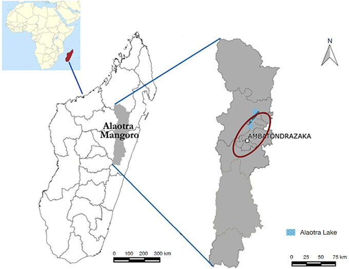 Figure 1. Location map of study area, Alaotra Lake Region, Ambatondrazaka District — Carte de localisation de la zone d’étude, la région du Lac d’Alaotra, district d’Ambatondrazaka.
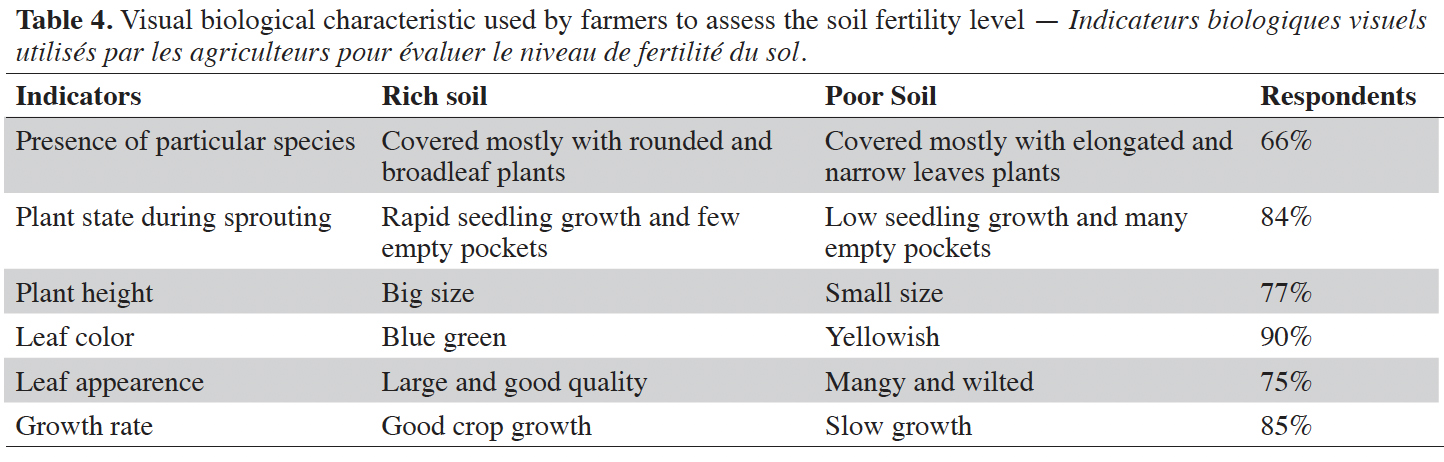
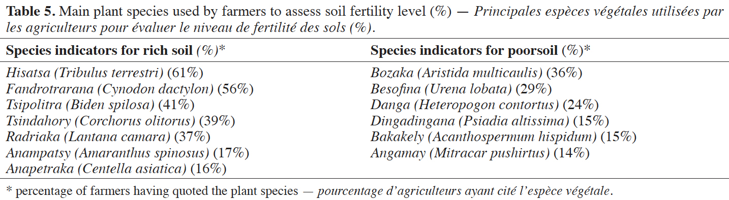
2.2. Methodology
5The method is based on a conceptual framework for assessing farmers' soil knowledge, summarized in figure 2. The methodology is focused on surveys, augmented by several participatory research tools. One hundred farmers (both growers and breeders) were chosen at random to participate in the surveys.
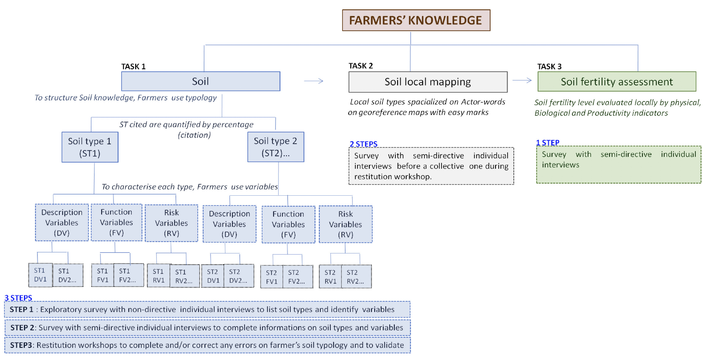 Figure 2. Methodology framework to study soil farmer’s knowledge — Cadre méthodologique pour étudier les connaissances des agriculteurs concernant le sol.
6Study approach for soil local knowledge. The method used here is the concept of structuring knowledge on real object including the creation of entities (typology) and the use of variables to characterize each entity (Landais & Deffontaines, 1988; Blanchard, 2010).
7The method requires three distinct steps. The first step was an exploratory survey, based on non-directive individual interviews with local farmers designed to identify entities (here, soil local types) and to identify the main variables to characterize them. The second step was to conduct semi-directive interviews to follow up on individual surveys in order to further have individual variants responses on local soil types with their detailed characteristic variables. The third step was to organize a restitution workshop to complete and to find a collective consensus on farmer’s soil types. Data analysis was carried out by descriptive statistics with Xlstat.
8Study approach for soil local mapping design. In order to reconcile local soil knowledge with scientific soil knowledge, local soil maps were implemented using the MARP or PRA1 method (Kanté & Defoer, 1995; Blanchard, 2010). To design the local maps, farmers were asked to locate each of the soil types that they had cited during the surveys on georeferenced base maps with QGIS 2.0.1. These base maps were annotated with landmarks such as rice fields, ridge lines, main road and so on to help farmers. Surveys with directive individual interviews were conducted to design local soil maps which were validated during a restitution workshop.
9Study approach for farmer’s assessment on soil fertility. To clarify the criteria they used to evaluate the fertility of each recognized soil type, farmers were asked to identify local soil fertility indicators based on soil physical appearance, noticeable biological characteristics and performance (productivity with main yield) indicators.
10Xlstat was used for statistical analysis. The data were analyzed with descriptive statistics. Factorial Correspondence Analysis (FCA) was used to analyse the graphical correspondence between soil knowledge of farmers and local fertility visual indicators.
3. Results
3.1. Local soil types
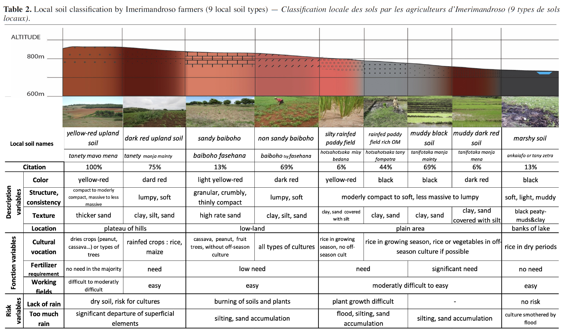
11Two local soil classifications have been established. The commune of Ilafy is considered to be representative of the south area of the District with Ambohitsilaozana and the commune Imerimandroso considered to be representative of the North with Ambatosoratra and Amparihitsokatra. Results show that farmers identified twelve types of soils in Ilafy (Table 1) and nine in Imerimandroso (Table 2). Each recognized soil type corresponds to one toposequence stage.
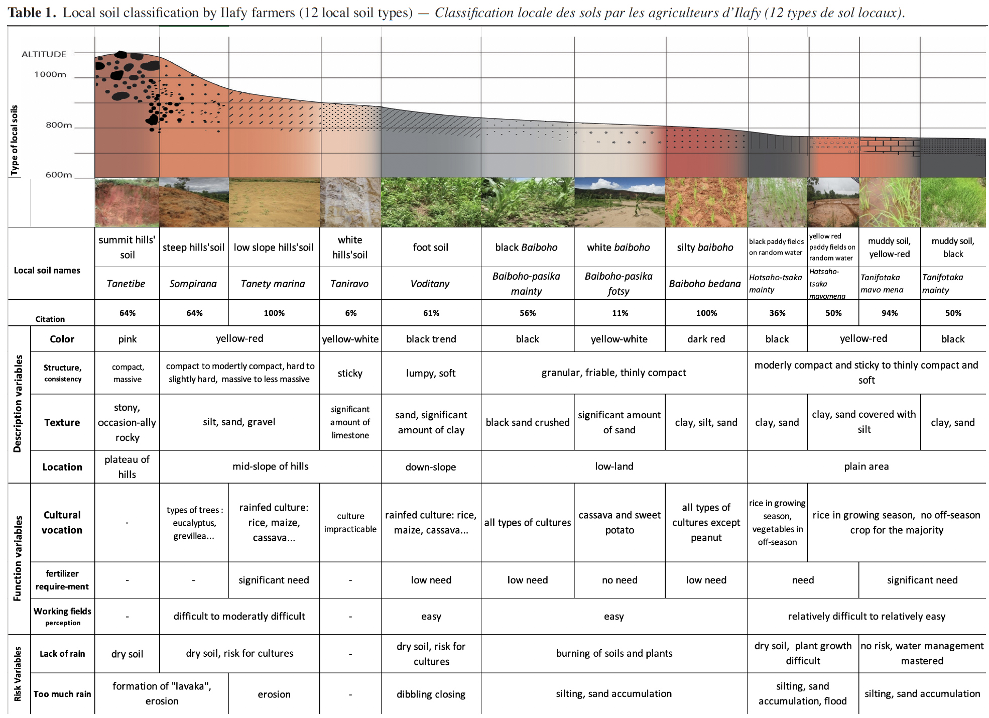
12To characterize each soil type, farmers used descriptive variables based on soil color, structure or consistency, texture and location. They also used functional variables based on cultural vocation, fertilizer requirement and perceived workability of fields. And finally, they evaluated risk variables which were particularly related to amount of rain.
13The reference to “citation” in tables 1 and 2 corresponds to the percentage of farmers who referenced a particular soil type. Thus, for example, for the first row in table 1, 64% of farmers recognized tanetibe (summit hills’ soil) as a type characterizing it as pink, compact, massive, stony and sometimes rocky. This type of soil is located on the plateau of hills. The main risk is the extreme drought in case of insufficient rainfall while too much rain would induce lavaka1 formation or significant erosion.
3.2. Local soil maps
14Local soil types have been mapped based on the spatial knowledge of local actors, as explained in above (Figures 3 and 4). Soil types recognized are classified in four categories for the two communes.
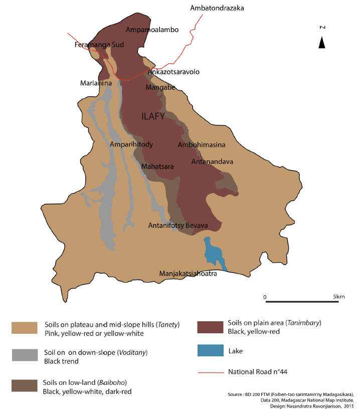 Figure 3. Local soil map by Ilafy farmers — Carte à dire d’acteurs : types de sols locaux, Ilafy.
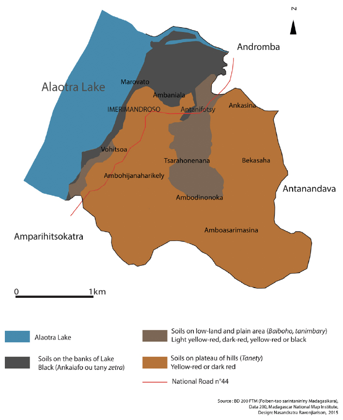
Figure 4. Local soil map by Imerimandroso farmers — Carte à dire d’acteurs : types de sols locaux, Imerimandroso.
15Ilafy farmers identified the following soils:
16– tanety (hill) including soils located on plateau and mid-slope of hills as the tanetibe (summit hills’ soil), sompirana (steep hills’ soil), tanety marina (low slope hills’soil), taniravo (white hills’ soil);
17– voditanety or voditany (foot soil) located on footslope (down the slope);
18– baiboho2 including soils located in low-lying areas (low-land) as the baiboho-pasika mainty (black baiboho), baiboho-pasika fotsy (white baiboho), baiboho bedana (silty baiboho);
19– tanimbary (ricefield) for all soils on plain area with hotsahotsaka mainty (black paddy fields on random water3), hotsahotsaka mavo mena (yellow red paddy fields on random water), tanifotaka mavo mena (yellow red muddy soil) and tanifotaka mainty (black muddy soil).
20Imerimandroso farmers identified the following soils:
21– tanety (hill) but only two soil types are distinguished, the tanety mavo mena (yellow-red upland soil) and the tanety manja mainty (dark-red upland soil);
22– baiboho, soils located on low-lands with the baiboho fasehana (sandy baiboho), baiboho tsy fasehana (non sandy baiboho);
23– tanimbary (ricefield) located on plain area of fields with hotsahotsaka misy bedana (silty rainfed paddy field), hotsahotsaka tany fompotra (rainfed paddy field rich in organic matter); tanifotaka manja mainty (muddy black soil), tanifotaka manja mena (muddy dark red soil);
24– ankaiafo or tany zetra (marshy soil) located on the banks of Alaotra Lake.
3.3. Local soil fertility indicators
25Farmers reported 14 main local indicators in soil fertility status. These are categorized in three classes: soil physical appearance, noticeable biological characteristic and soil performance based particularly on productivity indicators (Table 3).
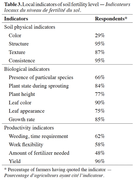
26Farmers defined a “fertile soil” as “tany masaka” which literally means cooked soil or “tany tsara”, meaning good soil and “infertile soil” as “tany manta”, meaning raw soil or “tany kotra”, poor soil.
27Soil physical appearance. For soil physical indicators, farmers referred to soil consistency, structure, texture and color with respectively 95%, 95%, 87% and 29% of respondents. Rich soils were black or having dark color and were perceived through their granular, friable, crumbly or lumpy structure. They were, as well, soft, thinly compacted and characterized by a balanced ratio between sand, silt and clay. And poor soils were lighter or red, massive and resistant. They were sticky, hard, compact and significant disproportions between sand, silt and clay were noticed (Figure 5).
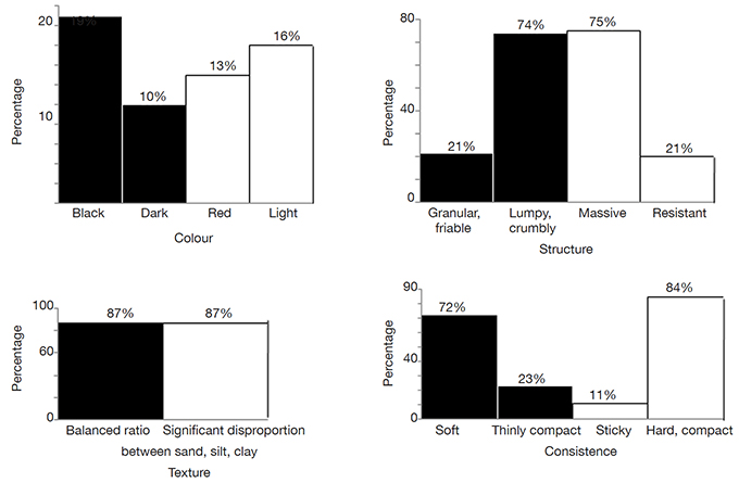 Figure 5. Soil physical indicators used by farmers to assess soil fertility level — Indicateurs physiques des sols utilisés par les agriculteurs pour évaluer le niveau de fertilité du sol.

28Figure 6 shows the score-plot for the first two axes F1 and F2 from a Factorial Correspondence Analysis (FCA) between soil knowledge and fertility perception according to soil physical status in Ilafy. Axes F1 and F2 explain 41% of the total variation, this is sufficient to endorse the results.
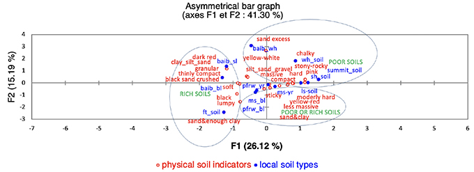
Figure 6. Correspondence between local soil knowledge and local fertility assessment according to soil physical appearance in Ilafy — Correspondance entre les savoirs locaux sur les sols et la perception locale de la fertilité des sols en fonction des indicateurs physiques du sol, commune d’Ilafy.
Summit_soil: summit hills’soil — sol des plateaux des tanety; sh_soil: steep hills’soil — sol des pentes fortes; ls_soil: low slope hills’soil — sol des tanety à pentes faibles; wh-soil: white hills’soil — sol blanc; ft-soil: foot soil — sol des contrebas des versants; baib_bl: black baiboho — baiboho noir; baib_wh: white baiboho — baiboho blanc; baib_sl: silty baiboho — baiboho couvert de limon; pfrw_bl: black paddy fields on random water — terres à riz de régime hydrique aléatoire noir; pfrw_yr: yellowed-red paddy fields on random water — terres à riz de régime hydrique aléatoire jaune-rouge; ms_yr: muddy soil yellow-red — terre à boue jaune-rouge; ms_bl: muddy soil black — sol boueux noir.
29The results reveal that poor soils are mostly located on plateaus and mid-slope of hills. This includes summit hills’ soil, steep hills’ soil, white hills’ soil. Exceptionally soils located in low-lying areas classified as white baiboho also belong to this soil type. As for rich soils, they were mostly located from down-slope to low-land. This group includes foot soil, black baiboho and silty baiboho. Soils in plain areas were perceived as soils of varying levels of fertility. Farmers said that they might find rich soils as well as poor soils in paddy fields black on random water, paddy fields yellow-red on random water, yellow-red muddy soil and on black muddy soil. Low slope hills’soil located in mid-slope belongs also to this category. According to the survey, farmers said that it is possible to have “tanety masaka” ( rich hills’ soil) as well as “tanety kotra” (poor hills’ soil) in their exploitation.
30Figure 7 shows the score-plot for the first two axes F1 and F2 for a Factorial Correspondence Analysis (FCA) between soil knowledge and fertility perception according to soil physical status in Imerimandroso. Axes F1 and F2 explain 56% of the total variation.
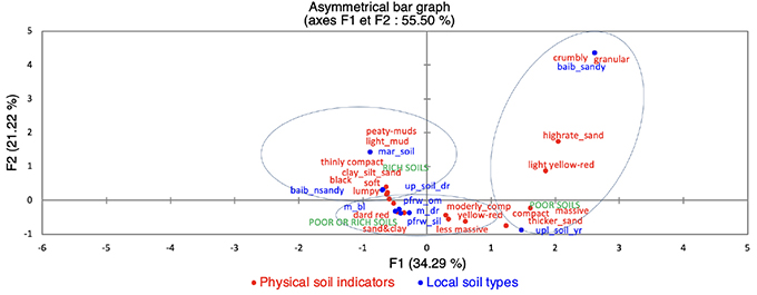 Figure 7. Correspondence between local soil knowledge and local fertility assessment according to soil physical appearance in Imerimandroso — Correspondance entre les savoirs locaux sur les sols et la perception locale de la fertilité en fonction des indicateurs physiques du sol, commune d’Imerimandroso.
up_soil_yr: yellow-red upland soil — tanety jaune-rouge; up_soil_dr: dark red upland soil — tanety rouge-noir à tendance noir; baib_sandy: sandy baiboho — baiboho sableux; baib_nsandy: non-sandy baiboho — baiboho non sableux; pfrw_sil: silty paddy fields on random water — terre à riz pluvial, couverte de limon; pfrw_om: paddy fields rich on organic matter on random water — terre à riz pluvial, riche en MO; m_bl: muddy black soil — terre à boue d’un noir brillant; m_dr: muddy dark red soil — terre à boue rouge sombre; mar_soil: marshy soil — sol des zones marécageuses.
31For Imerimandroso, figure 7 displays two soil types that farmers designated as poor soils. These are yellow-red upland soil and sandy baiboho. They mentioned three rich soils in their landscape: dark-red upland soil, non-sandy baiboho and marshy soil. Soils in the plain-area were those qualified by farmers as soils of varying levels of fertility as it is possible to find rich soils as well as poor soils in silty paddy field on random water, on paddy field rich in organic matter in random water, on muddy black soil and on muddy dark red soil.
32Farmers’ perception of soil fertility was not limited to soil physical indicators. Soil fertility was also evaluated locally through visual biological characteristic and productivity indicators.
33Visual biological characteristic indicators. Six main biological indicators are used locally to evaluate the soil fertility level (Table 4). Sixty-six percent of the farmers refer to the presence of particular species. Rich soils were mostly those covered with broad leaf and rounded plants and a poor one with elongated and narrow leaf plants. Table 5 summarizes those specific plant species.
34For the other biological indicators, 84% of farmers referred to the plant state during sprouting. A rich soil was identified by rapid emergence of seedlings and by a restricted number of empty planting holes in which seed had not germinated. Seventy-seven percent referred to plant height, stating that a rich soil was characterized by its ability to produce crops of big size. Farmers referred to leaf color (90%), leaf appearance (75%) and plant growth rate (85%), stating that a rich soil is recognized by plants with a permanent blue-green, large and good quality leaves and by a good crop growth. In addition, the slow emergence of seedlings, many empty planting holes, the small size of plants with yellowish, mangy and wilted leaves, and a low growth of plants would reference poor soil.
35Productivity or performance indicators. Finally, farmers used four main crop productivity indicators to complete their soil fertility assessment. Here, they referred particularly on the time required for weeding. A fertile soil will need 25 to 35 man-days per ha to weed with a frequency up to three times for a cultural cycle. A poor soil, however, will only need 9 to 18 man-days per ha for only one time weeding through a cultural cycle. Fifty-eight percent of farmers said that fertile soils were easy to work with 48% reporting that it requires little fertilizer. Yields expected in rich and poor soils for four main crops are summarized in table 6.
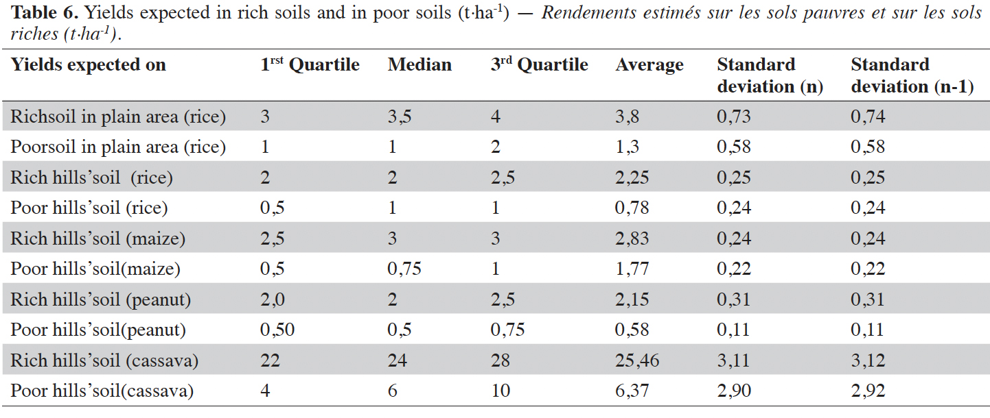
36Significant differences in yields were noticed between poor and rich soil. On a rich soil in plain areas, for example, farmers expected from 3 up to 4 t·ha-1 with an average of 3.8 t·ha-1 of paddy, whereas on poor soil they could only get an average yield of 1.3 t·ha-1. On rich hills’ soil, rice production should reach an average of 2.2 t·ha-1 compared to an average of 0.8 t·ha-1 on a poor one. The same pattern was indicated for cassava as well as for the other crops. A fertile soil was also judged by farmers for its ability to produce more compared to a poor soil.
4. Discussion
4.1. A conceptual framework for farmers' soil fertility assessment
37Here, a conceptual framework is proposed, based on insights gleaned from indigenous farmers that rest upon participatory approaches to identify their expertise in such a way as to permit incorporating it into both agricultural development projects and scientific investigations. This approach is based on distinct steps that should be followed throughout the surveys and collective sessions. Understanding farmers’ knowledge is a necessary prerequisite to create a joint discourse among development actors to serve as a basis for rural interventions (Brinkmann et al., 2018). The overall contribution of this framework is to provide clear guidance on how to best harness informal local soil knowledge to achieve detailed fine-scale and site-specific land characteristics (Dumont et al., 2014; Jacobi et al., 2017; Kuria et al., 2019).
38According to farmers in Alaotra Lake, types of soil vary according to the toposequence ie. the morphological succession units in the landscape. The twelve and the nine soil types recognized at Ilafy and Imerimandroso respectively corresponded to the character of each area’s landscape. The results coincide with the studies of Blanchart (2010), stating that location and position on the toposequence were used by Malian Farmers to define soil types.
4.2. Farmers knowledge links with scientific data
39Soil types recognized by farmers, in this study, converged with the previous studies of Raunet (1984), Garin (1998) and Rabenandro et al. (2009) (Table 7), but went further, in figures 8 and 9, to provide more detailed information than that obtained on the French soil classification reference (CPCS, 1967).
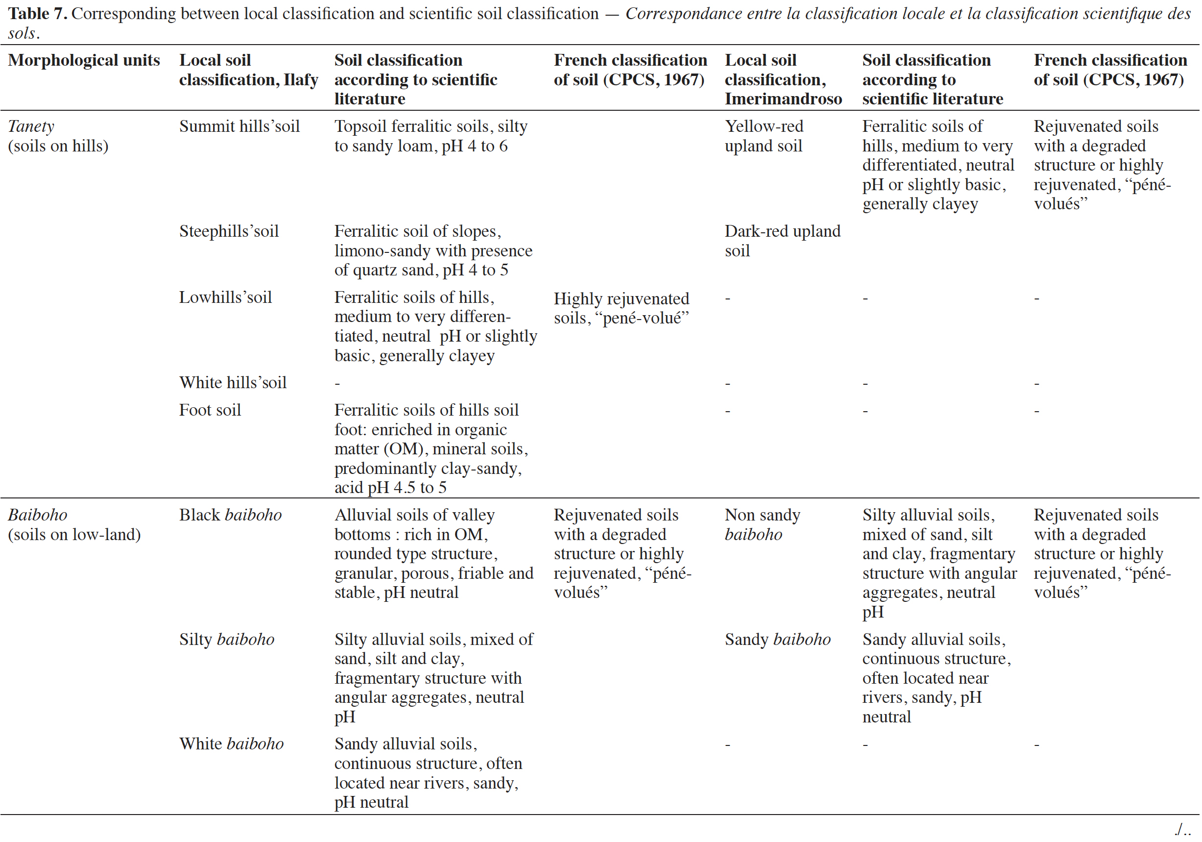
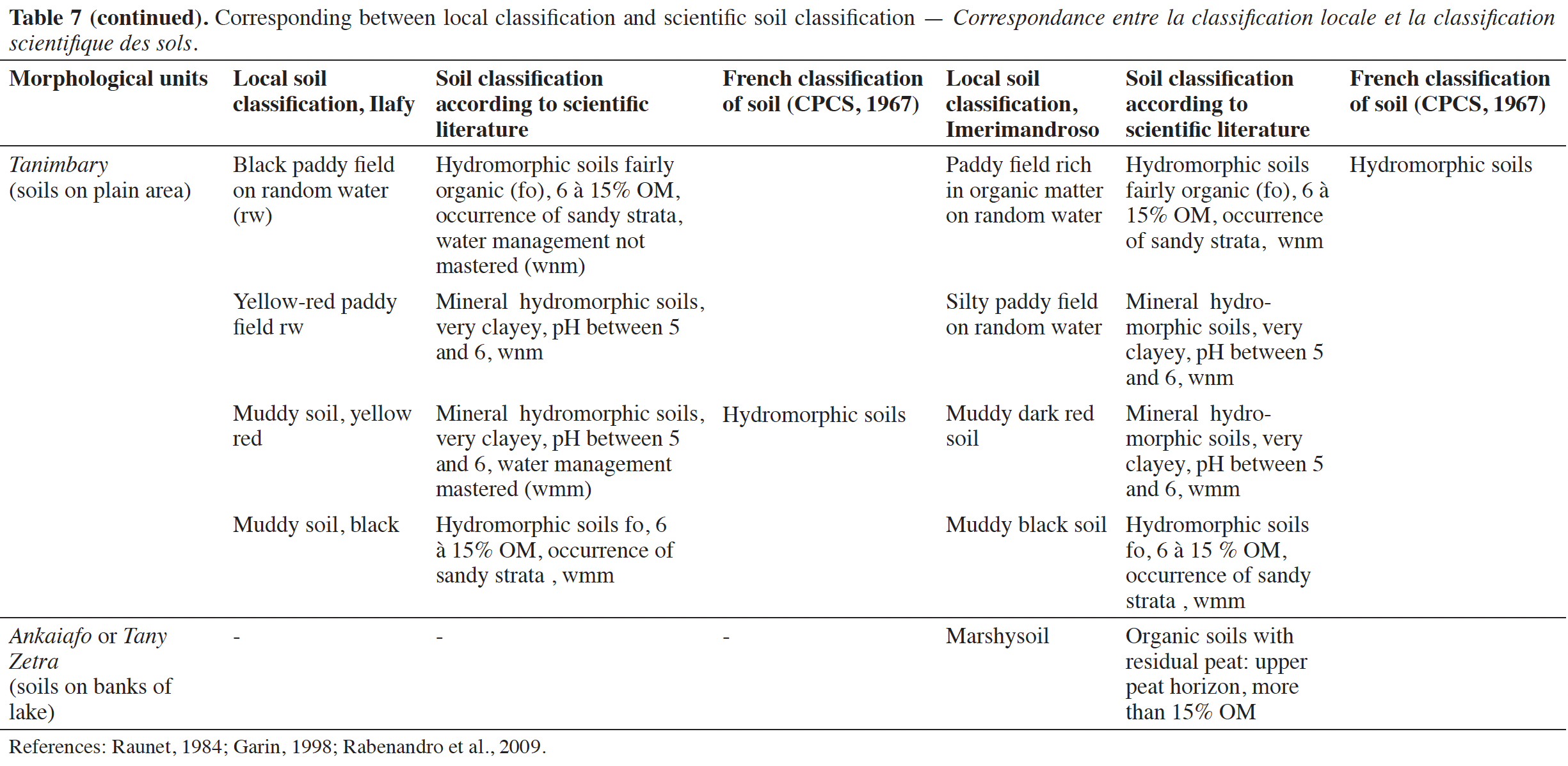
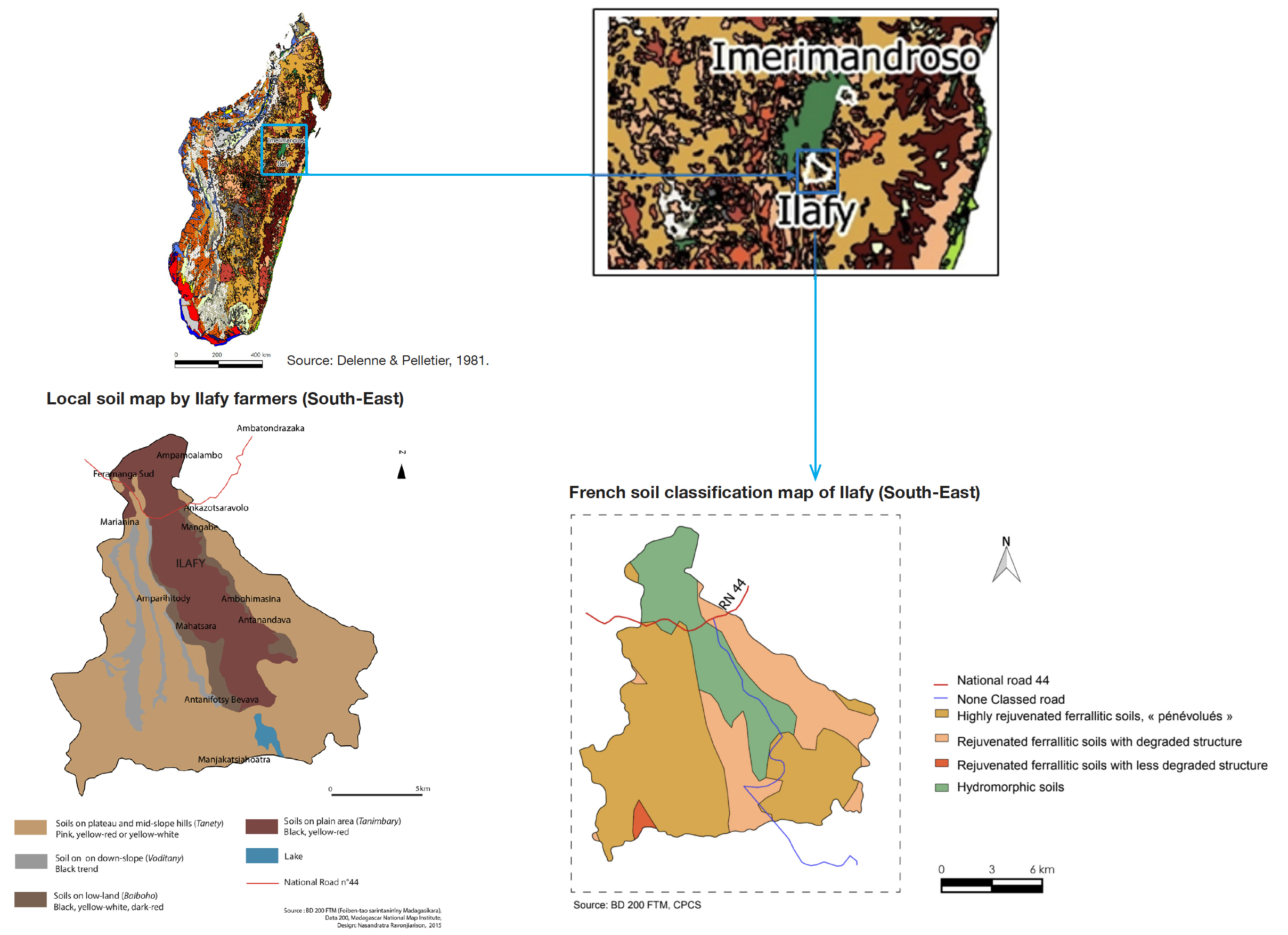
Figure 8. Local soil map compared to French soil Classification (CPCS), Ilafy — Essai comparatif de la carte locale des sols et classification française (CPCS), Ilafy.
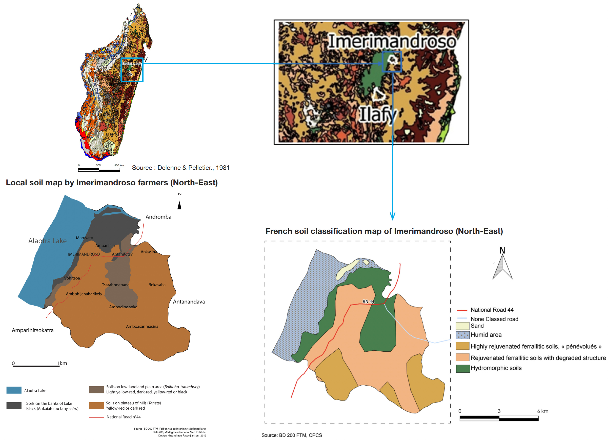
Figure 9. Local soil map compared to French soil Classification (CPCS), Imerimandroso — Essai comparatif de la carte locale des sols et la classification française (CPCS), Imerimandroso.
40Farmers in Alaotra Lake also articulated a well-defined and clear set of local indicators to assess soil fertility status. The use of soil physical indicators to evaluate soil quality is widespread (Barrera-Bassols & Zink, 2003).
41In many local evaluations of soil fertility status around the world, soil color, texture, structure and consistency were the most frequently used (Osunade, 1988; Ettema, 1994; Krasilnikov & Tabor, 2003; Oudewater & Martin, 2003; Barrera-Bassols et al., 2006; Blanchart, 2010; Dawoe et al., 2012). These variables, also attested here by farmers in the Alaotra Lake region, have a universal character, directly derived from sensory perceptions (Desbiez et al., 2004; Mikkelsen & Langohr, 2004; Barrera-Bassols et al., 2006; Blanchart, 2010). Darker soils, black or yellow-red dark, were regarded as rich soil, in Alaotra Lake. Similar findings were obtained by authors like Barrios & Trejo (2003) and Desbiez et al. (2004). Results for soil texture, structure and consistency found in this study were also in agreement with those reported by others (Habarurema & Steiner,1997; Barrios & Trejo, 2003), noting that rich soils were perceived by farmers as soils which are soft, thinly compact and characterized by a balanced ratio of sand, silt and clay.
42Biological indicators related to crop performance like plant state during sprouting, plant height, leaf color, leaf appearance, crop growth rate and weed species are also frequently mentioned elsewhere by local communities in assessing soil fertility status (Barrios et al., 2001; Barrios & Trejo, 2003; Birang et al., 2003; Desbiez et al., 2004; Blanchart, 2010).
43Corbeels et al. (2000) and Handayani et al. (2006) demonstrate the use of weed species as an efficient tool to judge the status of soil fertility like we can see in figure 10.
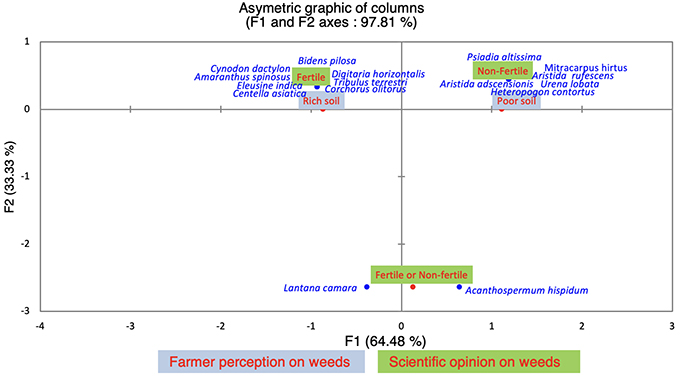
Figure 10. Correspondence between farmers’ perception and scientific research on plant species indicators (FCA, Factorial Correspondence Analysis). F1 and F2 axes were able to explain 97% of the total variation — Correspondance entre savoirs locaux et savoirs scientifiques concernant les indicateurs d’espèces végétales (FCA, Factorial Correspondence Analysis). Les axes F1 et F2 ont pu expliquer 97 % de la variation totale.
44The current FCA results are also consistent with those of Husson et al. (2010) confirming that farmers’ perception of weed species indicators is positively correlated with scientists’ expertise except for Lantana camara and Acanthospermum hispidum. Scientifically, these two species are not considered as indicators of soil fertility as they can be seen in all types of soil. Farmers consider L. camara to be an indicator of rich soil because it provides rich biomass to the soil by its large amounts of leaf litter, keeping the soil consistently black with organic matter. In contrast, soils were deemed exhausted with the spreading of A. hispidum which local farmers believe dries and hardens the soil.
45Finally, to assess soil fertility, farmers refer to productivity indicators. It has also been reported by Gruver & Weil (2006), Mairura et al. (2007) and Njeru et al. (2010) that soil fertility can be evaluated through higher crop yield.
4.3. Farmers’s soil knowledge inputs for future research and development activities
46This study contributes to a more comprehensive understanding of local knowledge which is useful in the context of high costs of science-based soil classification and mapping (Brinkmann et al., 2018). Results like these, consistent with the more costly findings of modern soil science (Nath et al., 2015) may be of great interest in designing any new agricultural development and research efforts in Madagascar, especially in the Lake Alaotra Region. The proposed framework may provide a foundation for a more in-depth study for other sites as a follow-up and perspective to this study.
5. Conclusions
47The study revealed that farmers in Alaotra Lake successfully identify local soil classification. For all five communes under investigation, results indicated two different soil classifications, twelve in the south and nine in the north. Topography and geographical location played an important role in these typologies.
48Farmers’ soil type descriptions, which converged with previous work, provided considerably more operational detail than that captured by French soil classification (CPCS). This underscores the importance of working together with farmers to harness their expertise when developing site-specific agricultural practices that are effective, efficient and sustainable.
49In assessing soil fertility status, these indigenous farmers of Alaotra Lake used 14 main local indicators, including four physical soil properties, six bio-ecological and four soil productivity indicators. Their descriptions converged with those used by scientists, and have been proved to be identical to those used by other farmers around the world. Their comprehensive soil knowledge, covering a large area of roughly 2,000 km2, provides the foundation for a conceptual framework, proposed here, that holds promise for bringing innovative knowledge and goals of local farmers and scientific researchers into better alignment. Insights from this knowledge can serve as a common language to facilitate communication between farmers and researchers for the co-design of innovative agricultural practices.
Aknowledgements
50The authors thank and acknowledge the financial and technical support from IFS (International Foundation for Science) and STIAS (Stellenbosch Institute for Advanced Study). They thank as well farmers in Alaora Lake who shared their wealth of knowledge during surveys.
Bibliographie
Ansong Omari R. et al., 2018. Exploring farmers’indigenous knowledge of soil quality and fertility management practices in selected farming communities of the Guinea savannah agro-ecological zone of Ghana. Sustainability, 10(4), 1034, doi.org/10.3390/su10041034
Barrera-Bassols N. & Zinck J.A., 2003. Ethnopedology: a worldview on the soil knowledge of local people. Geoderma, 111(3-4), 171-195, doi.org/10.1016/s0016-7061(02)00263-x
Barrera-Bassols N., Zinck J. &Van Ranst E., 2006. Local soil classification and comparison of indigenous and technical soil maps in a Mesoamerican community using spatial analysis. Geoderma, 135, 140-162, doi.org/10.1016/j.geoderma.2005.11.010
Barrios E. et al., 2001. Identifying and classifying local indicators of soil quality. Eastern Africa Version. Participatory methods for decision making in natural resource management. CIAT-SWNM-TSBF-AHI.
Barrios E. &Trejo M., 2003. Implications of local soil knowledge for integrated soil management in Latin America. Geoderma, 111, 217-231, doi.org/10.1016/s0016-7061(02)00265-3
Birang M., Hauser S. & Amougou D.L., 2003. Farmer's perceptions of the effects of earthworms on soil fertility and crop performance in southern Cameroon. Pedobiologia, 47(5/6), 819-824, doi.org/10.1078/0031-4056-00265
Blanchard M., 2010. Gestion de la fertilité des sols et rôle du troupeau dans les systèmes coton - céréales - élevage au Mali-Sud. Savoirs techniques locaux et pratiques d’intégration agriculture - élevage. Thèse de doctorat : Université Paris-Est, Créteil, Val de Marne (France).
Brinkmann K., Samuel L., Peth S. & Buerkert A., 2018. Ethnopedological knowledge and soil classification in SW Madagascar. Geoderma Regional, 14, e00179, doi.org/10.1016/j.geodrs.2018.e00179
Corbeels M., Shiferaw A. & Haile M., 2000. Farmers’ knowledge of soil fertility and local management strategies in Tigray, Ethiopia. Managing Africa’s Soils No.10. Edinburgh: IIED.
CPCS, 1967. Classification des sols. Travaux Commission de Pédologie et de Cartographie des Sols. Rapport Multiple, Grignon.
Dawoe E. et al., 2012. Exploring farmers’ local knowledge and perceptions of soil fertility and management in the Ashanti Region of Ghana. Geoderma ,179-180, 96-103, doi.org/10.1016/j.geoderma.2012.02.015
Delenne M.F. & Pelletier F., 1981. Carte du potentiel des unités physiques, au 1:1 000 000e. Bondy, France : ORSTOM.
Desbiez A., Matthews R., Tripathi B. & Ellis-Jones J., 2004. Perceptions and assessment of soil fertility by farmers in the mid-hills of Nepal. Agric. Ecosyst. Environ., 103, 191-206, doi.org/10.1016/j.agee.2003.10.003
Dumont E.S. et al., 2014. Farmers in Côte d'Ivoire value integrating tree diversity in cocoa for the provision of ecosystem services. Agrofor. Syst., 88, 1047-1066, doi.org/10.1007/s10457-014-9679-4
Ettema C.H., 1994. Indigenous soil classifications: what is their structure and function, and how do they compare to scientific soil classifications? Enschede, The Netherlands : ITC, 1994,
Fairhead J. & Leach M., 1994. Représentations culturelles africaines et gestion de l’environnement. Politique Afr., 53, 11-24.
Furbee L., 1989. A folk expert system: soils classification in the Colca Valley Peru. Anthropol. Quarterly, 62, 83-102, doi.org/10.2307/3318128
Gandah M., Stein A., Brouwer J. & Bouma J., 2000. Dynamics of spatial variability of millet growth and yields at three sites in Niger, West Africa and implications for precision agriculture research. Agric. Syst., 63, 123-140., doi.org/10.1016/s0308-521x(99)00076-1
Garin P., 1998. Dynamiques agraires autour de grands périmètres irrigués : le cas du lac Alaotra à Madagascar. Thèse de doctorat : Université de Paris X-Nanterre (France).
Gonzalez R.M., 1995. KBS, GIS and documenting indigenous knowledge. Indigenous Knowl. Dev. Monit., 3, 5-7.
Gruver J.B. & Weil R.R., 2006. Farmer perceptions of soil quality and their relationship to management sensitive soil parameters. Renewable Agric. Food Syst., 22, 271-281, doi.org/10.1017/s1742170507001834
Habarurema E. & Steiner K.G., 1997. Soil suitability classification by farmers in southern Rwanda. Geoderma, 75, 75-87, doi.org/10.1016/s0016-7061(96)00078-x
Handayani I.P. et al., 2006. Nurturing soil science in Indonesia by combining indigenous and scientific knowledge. Soil Horiz., 47(4), 79-80, doi.org/10.2136/sh2006.4.0079
Husson O. et al., 2010. Les principales plantes de jachères et adventices de Madagascar. Manuel pratique du semis direct à Madagascar. Montpellier, France : Cirad.
Jacobi J. et al., 2017. Whose knowledge, whose development? Use and role of local and external knowledge in agroforestry projects in Bolivia. Environ. Manage., 59, 464-476, doi.org/10.1007/s00267-016-0805-0
Kanté S. & Defoer T., 1995. Comment les paysans classent et gèrent leur terre ? Cah. Rech. Dév., 42, 46-61.
Krasilnikov P. & Tabor J.A., 2003. Perspectives on utilitarian ethnopedology. Geoderma, 111, 197-215, doi.org/10.1016/s0016-7061(02)00264-1
Kuria A.W. et al., 2019. Farmers' knowledge of soil quality indicators along a land degradation gradient in Rwanda. Geoderma regional, 16, e00199, doi.org/10.1016/j.geodrs.2018.e00199
Laekemariam F., Kibret K. & Mamo T., 2017. Farmers’ soil knowledge, fertility management logic and its linkage with scientifically analyzed soil properties in southern Ethiopia. Agric. Food Secur., 6, 57, doi.org/10.1186/s40066-017-0138-0
Landais E. & Deffontaines J.P., 1988. Les pratiques des agriculteurs, points de vue sur un courant nouveau de la recherche agronomique. Études Rurales, 109, 125-158.
Luxereau A. & Roussel B., 1997. Changements écologiques et sociaux au Niger. Paris : L’Harmattan.
M’Biandoun M. & Bassala J-P. O., 2007. Savoir paysan et fertilité des terres au Nord-Cameroun. Cah. Agric., 16, 185-197, doi.org/10.1684/agr.2007.0100
Mairura F. et al., 2007. Integrating scientific and farmers' evaluation of soil quality indicators in Central Kenya. Geoderma, 139, 134-143, doi.org/10.1016/j.geoderma.2007.01.019
Matuk F.A. et al., 2020. Including diverse knowledges and worldviews in environmental assessment and planning: the Brazilian Amazon Kaxinawá Nova Olinda indigenous land case. Ecosyst. People, 16(1), 95-113, doi.org/10.1080/26395916.2020.1722752
Mikkelsen J.H. & Langohr R., 2004. Indigenous knowledge about soils and a sustainable crop production, a case study from the Guinea Woodland Savannah, Northern Region, Ghana. Danish J. Geogr., 104(2), 13-26, doi.org/10.1080/00167223.2004.10649515
Nath A.J., Lal R. & Das A.K., 2015. Ethnopedology and soil properties in bamboo (Bambusa sp.) based agroforestry system in North East India. Catena, 135, 92-99.
Njeru M., Hjalten J. & Kimani S., 2010. The effect of Push-pull management and fertilization in central Kenya: the effect of Push-pull management and different fertilization strategies on maize crop yield in central Kenya. London: Lambert Academic Publishing.
Osunade M., 1988. Soil suitability classification by small farmers. Prof. Geogr., 40(2), 194-201, doi.org/10.1111/j.0033-0124.1988.00194.x
Oudewater N. & Martin A., 2003. Methods and issues in exploring local knowledge of soils. Geoderma, 111, 387-401, doi.org/10.1016/s0016-7061(02)00273-2
Pawluk R., Sandor J. & Tabor J., 1992. The role of indigenous soil knowledge in agricultural development. J. Soil Water Conserv., 47, 298-302.
Rabenandro T., Dupin B. & Hyac P., 2009. Guide synthétique d’agronomie et d’agro-écologie dans le contexte de la rive-ouest du Lac Alaotra. Document préparé par AVSF – novembre 2009. Antananarivo : Ministère de l’Agriculture de la République de Madagascar.
Raunet M., 1984. Région du Lac Alaotra Madagascar. Le milieu physique, aptitudes à la mise en valeur agricole, système et structure. Montpellier, France : GERDAT-IRAT.
Rushemuka N.P., Bizozab R.A., Mowo J.G. & Bock L., 2014. Farmers’ soil knowledge for effective participatory integrated watershed management in Rwanda: toward soil-specific fertility management and farmers’ judgmental fertilizer use. Agric. Ecosyst. Environ., 183, 145-159, doi.org/10.1016/j.agee.2013.10.020
Saïdou A. et al., 2004. Sustainable soil fertility management in Benin learning from farmers. NJAS Wageningen J. Life Sci., 52, 349-369, doi.org/10.1016/s1573-5214(04)80021-6
Saito K. et al., 2006. Farmers' knowledge of soils in relation to cropping practices: a case study of farmers in upland rice based slash-and-burn systems of northern Laos. Geoderma, 136, 64-74, doi.org/10.1016/j.geoderma.2006.02.003
Seck M., 2007. Expériences vécues des communautés s’adaptant aux changements climatiques : les dimensions humaines de l’adaptation aux changements climatiques. Rapport final. Dakar : Ministère de l’Environnement du Sénégal.
WinklerPrins A.M.G.A. & Sandor J.A., 2003. Local soil knowledge: insight, application, and challenges. Geoderma, 111, 165-170, doi.org/10.1016/s0016-7061(02)00262-8
Notes
1 MARP : Méthode d'Analyse Rapide et de Planification Participative or PRA : Participatory Rural Appraisal.
1 Literally means « hole » : types of erosion on hill’slope
2 Baiboho : alluvial soils from water erosive action, seasonally flooded
3 uncontrolled irrigation system
